| November 20, 2023 Central Louisiana Tornadoes |
|
The National Weather Service office in Lake Charles Louisiana has conducted storm surveys across Central Louisiana, with the survey results below.
|
| Big Creek, LA Tornado |
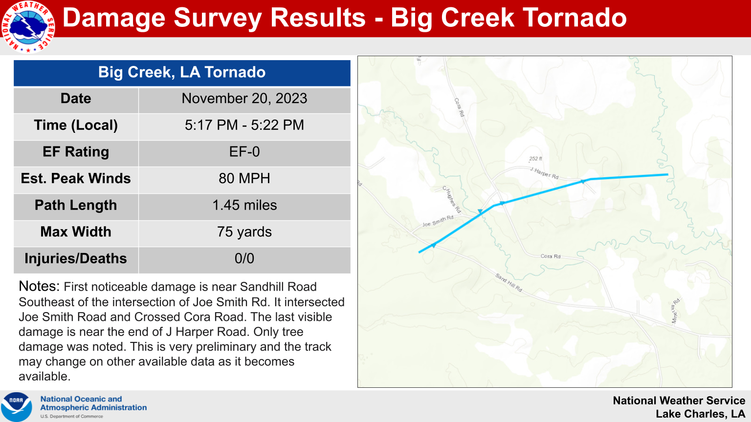 |
.Big Creek...

Rating:                 EF0
Estimated Peak Wind:    80 mph
Path Length /statute/:  1.45 miles
Path Width /maximum/:   75 yards
Fatalities:             0
Injuries:               0

Start Date:             11/20/2023
Start Time:             05:17 PM CST
Start Location:         4 SSE Lacamp / Vernon Parish / LA
Start Lat/Lon:          31.1047 / -92.8845

End Date:               11/20/2023
End Time:               05:22 PM CST
End Location:           5 SE Lacamp / Vernon Parish / LA
End Lat/Lon:            31.1109 / -92.8617

Survey Summary:
First noticable damage is near Sandhill Road Southeast of the
intersection of Joe Smith Rd. It intersected Joe Smith Road and
Crossed Cora Road. The last visible damage is near the end of J
Harper Road. Only tree damage was noted. This is very prelimenary
and the track may change on other available data as it becomes
available.
| Oden Lake, LA Tornado |
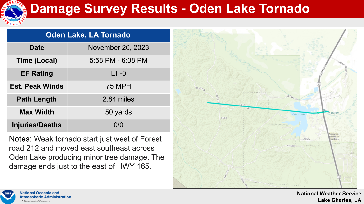 |
.Oden Lake...

Rating:                 EF0
Estimated Peak Wind:    75 mph
Path Length /statute/:  2.84 miles
Path Width /maximum/:   50 yards
Fatalities:             0
Injuries:               0

Start Date:             11/20/2023
Start Time:             05:58 PM CST
Start Location:         4 NW Woodworth / Rapides Parish / LA
Start Lat/Lon:          31.1975 / -92.5551

End Date:               11/20/2023
End Time:               06:08 PM CST
End Location:           3 N Woodworth / Rapides Parish / LA
End Lat/Lon:            31.1946 / -92.5073

Survey Summary:
Weak tornado start just west of Forest road 212 and moved east
southeast across Oden Lake producing minor tree damage. The
damage ends just to the east of HWY 165.
| Marksville, LA Tornado |
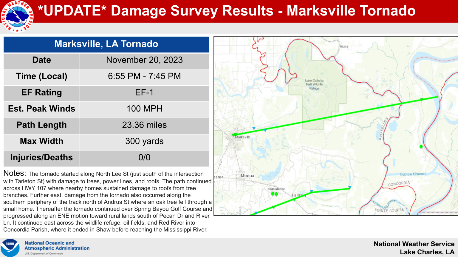 |
.Marksville Tornado...

Rating:                 EF1
Estimated Peak Wind:    100 mph
Path Length /statute/:  23.36 miles
Path Width /maximum/:   300 yards
Fatalities:             0
Injuries:               0

Start Date:             11/20/2023
Start Time:             06:55 PM CST
Start Location:         Marksville / Avoyelles Parish / LA
Start Lat/Lon:          31.1316 / -92.0673

End Date:               11/20/2023
End Time:               07:45 PM CST
End Location:           10 NW Fort Adams / Avoyelles Parish / MS
End Lat/Lon:            31.1862 / -91.6781

Survey Summary:
The tornado started along North Lee St (just south of the
intersection with Tarleton St) with damage to trees, power lines,
and roofs. The path continued across HWY 107 where nearby homes
sustained damage to roofs from tree branches. Further east, damage
from the tornado also occurred along the southern periphery of
the track north of Andrus St where an oak tree fell through a
small home. Thereafter the tornado continued over Spring Bayou
Golf Course and progressed along an ENE motion toward rural lands
south of Pecan Dr and River Ln. It continued east across the
wildlife refuge, oil fields, and Red River into Concordia Parish,
where it ended in Shaw before reaching the Mississippi River.
| Cottonport, LA Tornado |
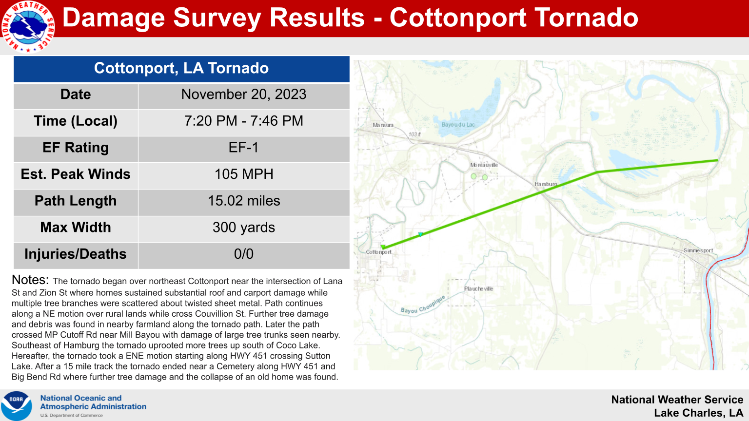 |
...Cottonport Tornado...

Rating:                 EF1
Estimated Peak Wind:    105 mph
Path Length /statute/:  15.02 miles
Path Width /maximum/:   300 yards
Fatalities:             0
Injuries:               0

Start Date:             11/20/2023
Start Time:             07:20 PM CST
Start Location:         1 E Cottonport / Avoyelles Parish / LA
Start Lat/Lon:          30.9897 / -92.0419

End Date:               11/20/2023
End Time:               07:46 PM CST
End Location:           4 NNE Simmesport / Avoyelles Parish / LA
End Lat/Lon:            31.04 / -91.7971

Survey Summary:

The tornado began over northeast Cottonport near the intersection
of Lana St and Zion St where homes sustained substantial roof and
carport damage while multiple tree branches were scattered about
twisted sheet metal. Path continues along a NE motion over rural
lands while cross Couvillion St. Further tree damage and debris
was found in nearby farmland along the tornado path. Later the
path crossed MP Cutoff Rd near Mill Bayou with damage of large
tree trunks seen nearby. Southeast of Hamburg the tornado uprooted
more trees up south of Coco Lake. Hereafter, the tornado took a
ENE motion starting along HWY 451 crossing Sutton Lake. After a 15
mile track the tornado ended near a Cemetery along HWY 451 and
Big Bend Rd where further tree damage and the collapse of an old
home was found.

&&

EF Scale: The Enhanced Fujita Scale classifies tornadoes into the
following categories:

EF0.....65 to 85 mph
EF1.....86 to 110 mph
EF2.....111 to 135 mph
EF3.....136 to 165 mph
EF4.....166 to 200 mph
EF5.....>200 mph

NOTE:
The information in this statement is preliminary and subject to
change pending final review of the event and publication in
NWS Storm Data.


