
In the Upper Midwest, heavy to excessive rain may bring flash and urban flooding through Wednesday. Scattered severe thunderstorms capable of large hail and damaging wind gusts are possible from the central High Plains into the Upper Midwest Wednesday. Extreme heat is ongoing over the Desert Southwest through Thursday. Read More >
Lake Charles, LA
Weather Forecast Office
|
FEBRUARY 12-13 2007 |
| Overview |
|
Another strong storm system courtesy of El Niño impacted much of the region from Monday February 12, through early Tuesday, February 13. This system brought flash flooding to parts of Southeast Texas, large hail up to golf ball size in numerous locations, wind damage, and 4 confirmed tornadoes. These tornadoes were the first in the Lake Charles County Warning Area to be rated using the new Enhanced Fujita Scale. For more information on the Enhanced Fujita Scale, please click here. |
| Local Storm Reports |
| SPC Storm Reports for February 12-13 2007 2/13/07 Google Earth KML data file |
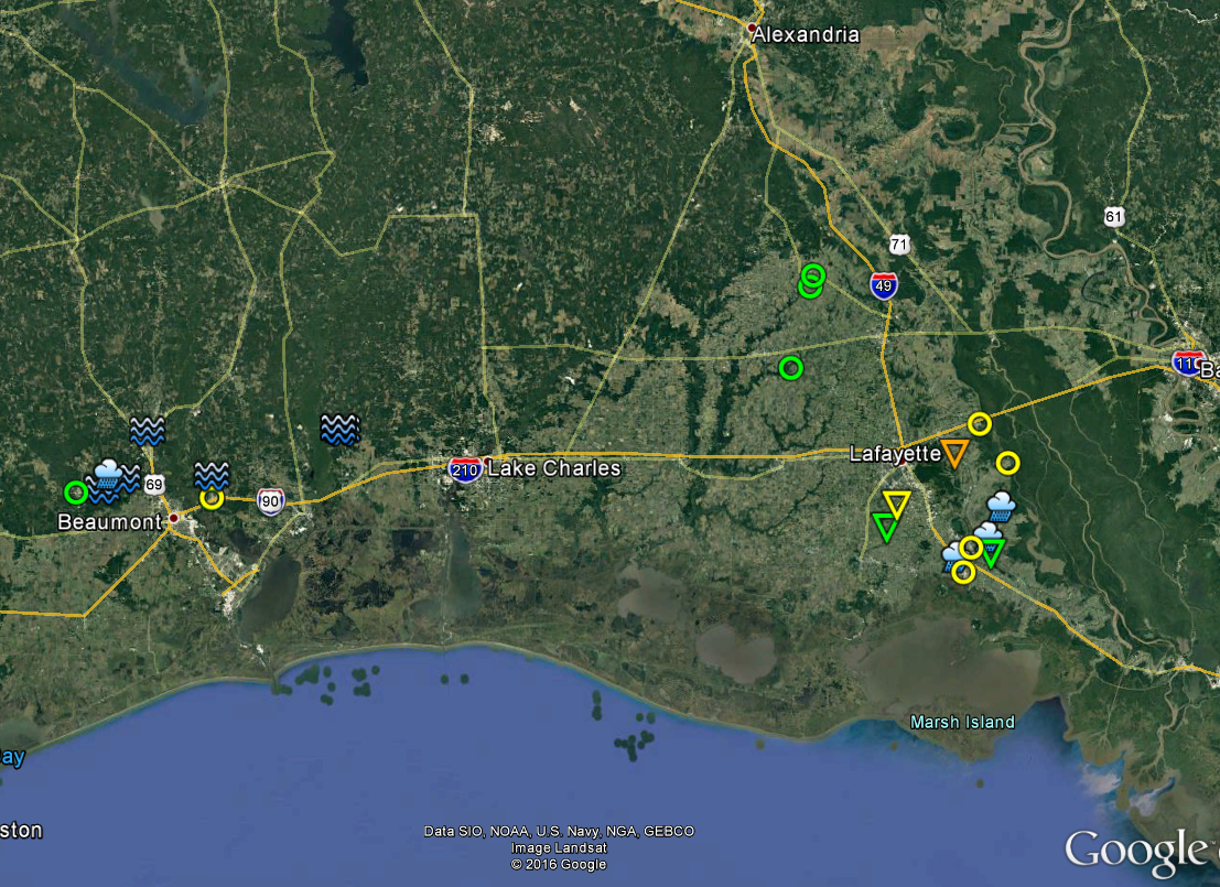
| Google Map Legend | |||||
|
Tornadoes |
EF0 |
EF1 |
EF2 |
||
|
Hail |
<1" |
1"+ |
2"+ |
3"+ |
4"+ |
| T'storm Wind |
|
||||
|
Flooding |
|
||||
Forecasts
Graphical Forecasts
Wet Bulb Globe Temps
Aviation Weather
Activity Planner
Mardi Gras Decision Support
Marine Forecasts
Local Products
Model Data
Forecaster's Discussion
Fire Weather
Other Links
National Hurricane Ctr
Storm Prediction Ctr
Weather Prediction Ctr
Other Links
Office History
LCH StoryMap
Hazards
Severe Weather
Tropical Weather
National Outlooks
Local Storm Reports
Tropical Cyclone Reports
Current
Satellite Data
Observations
Tide Data
Hydrology
Calcasieu Par. Network
Jefferson Co. DD6 Network
River/Lake Forecasts
Radar
Shreveport (SHV)
New Orleans (LIX)
Fort Polk (POE)
Houston/Galveston (HGX)
Lake Charles (LCH)
Probabilistic Pages
Probabilistic DSS
Probabilistic Snowfall
Probabilistic Rainfall
US Dept of Commerce
National Oceanic and Atmospheric Administration
National Weather Service
Lake Charles, LA
500 Airport Boulevard
Lake Charles, LA 70607
(337) 477-5285 M-F 8a to 4p only
Comments? Questions? Please Contact Us.

