Dangerous and extreme heat will remain across portions of the Central U.S. this week, persisting across the Mid to Lower Mississippi Valleys, Gulf Coast, Southern Plains and portions of Texas. A heat wave over the Southwest will intensify late this week. Severe thunderstorms and flash flooding will spread from the Great Lakes/Ohio Valley to the Mid-Atlantic and Northeast the next few days. Read More >
Lake Charles, LA
Weather Forecast Office
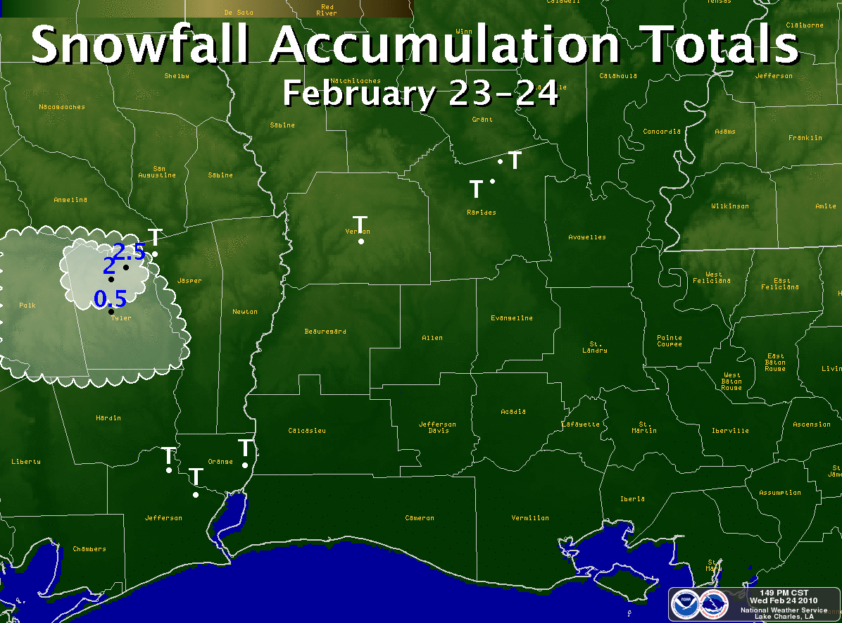
| February 23-24, 2010 Snow |
click on map for larger image
A upper level trough moved across Texas and Louisiana from Tuesday, February 23, 2010 into early Wednesday, February 24, 2010. Widespread light rain developed ahead of the system and spread across southeast Texas and southwest Louisiana on Tuesday afternoon and evening. Relatively cold and dry air at the surface with temperatures and dewpoints in the 30s led to the rain mixing with and eventually changing over to snow across most of southeast Texas and far western Louisiana near the Sabine River.
Snow was most persistent across the Lakes region of southeast Texas, where a combination of the best upper level lift, cold temperatures aloft, and higher surface elevations away from the Gulf Coast allowed for the snow to accumulate across Tyler and Jasper Counties. Some areas of northern Tyler County reported over 2 inches of snowfall. Elsewhere across Southeast Texas, the snow only fell for a brief time, and with temperatures several degrees above freezing, no snow accumulation was seen.
Because the snow was not measurable at any of the official climate stations (such as Beaumont/Port Arthur and Alexandria), no official snowfall records were set. However, this was the 3rd measurable snowfall across some part of Southeast Texas for the 2009-2010 winter season - the most snow events seen in one winter across southeast Texas since 1973!
|
2/23/10 to 2/24/10 Snow Reports |
|||
| TEXAS | LOUISIANA | ||
| Rockland | 2.5" | Leesville | T |
| Colmesneil | 2.0" | Alexandria | T |
| Chester | 2.0" | Ball | T |
| Woodville | 0.5" | ||
| Ebenezer | T | ||
| Click here for a list of all Local Snow Reports | |||
|
February 23-24, 2010 Pictures |
||||||
|
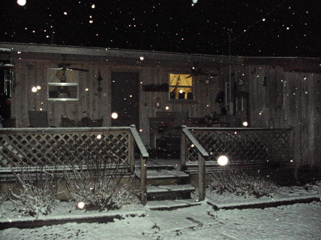
Snow at Booger Hill near Colmesneil, TX (courtesy of KFDM-TV) |
Forecasts
Fire Weather
Graphical Forecasts
Wet Bulb Globe Temps
Aviation Weather
Activity Planner
Mardi Gras Decision Support
Marine Forecasts
Local Products
Model Data
Forecaster's Discussion
Other Links
National Hurricane Ctr
Storm Prediction Ctr
Weather Prediction Ctr
Other Links
Office History
LCH StoryMap
Hazards
Severe Weather
Tropical Weather
National Outlooks
Local Storm Reports
Tropical Cyclone Reports
Current
Satellite Data
Observations
Tide Data
Hydrology
Calcasieu Par. Network
Jefferson Co. DD6 Network
River/Lake Forecasts
Radar
Shreveport (SHV)
New Orleans (LIX)
Fort Polk (POE)
Houston/Galveston (HGX)
Lake Charles (LCH)
Probabilistic Pages
Probabilistic DSS
Probabilistic Snowfall
Probabilistic Rainfall
US Dept of Commerce
National Oceanic and Atmospheric Administration
National Weather Service
Lake Charles, LA
500 Airport Boulevard
Lake Charles, LA 70607
(337) 477-5285 M-F 8a to 4p only
Comments? Questions? Please Contact Us.