
Dangerous and extreme heat will remain across portions of the Central U.S. this week, persisting across the Mid to Lower Mississippi Valleys, Gulf Coast, Southern Plains and portions of Texas. A heat wave over the Southwest will intensify late this week. Severe thunderstorms and flash flooding will spread from the Great Lakes/Ohio Valley to the Mid-Atlantic and Northeast the next few days. Read More >
Lake Charles, LA
Weather Forecast Office
A series of rain events produced widespread heavy rainfall across the region with the highest amounts of 14 to 25 inches noted across Central Louisiana. This occurred on top of what was already a wet year. The result was the worst flooding on record at several of the gauging stations in Southwest and Central Louisiana.
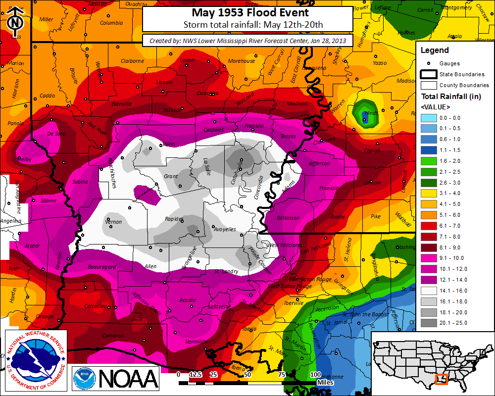
Historical crests on area rivers
courtesy NWS AHPS
| Flood State (ft) | ||||||
| Body of water | Location | Crest (ft) | Date | Minor | Major | All-time |
| Calcasieu R. | Glenmora | 21.55 | 5/19/53 | 12 | 18 | record |
| Calcasieu R. | Oakdale | 22.62 | 5/19/53 | 12 | 22 | record |
| Calcasieu R. | Oberlin | 26.53 | 5/19/53 | 13 | 19 | record |
| Calcasieu R. | Kinder | 32.00 | 5/19/53 | 16 | 23 | record |
| Calcasieu R. | Old Town Bay | 16.10 | 5/21/53 | 4 | 8 | record |
| Whisky Chitto C. | Mittie | 32.80 | 5/18/53 | 15 | 23 | record |
| B. Nezpique | Basile | 34.39 | 5/20/53 | 22 | 28 | record |
| B. Des Cannes | Eunice | 22.36 | 5/20/53 | 16 | 21 | record |
| B. Cocodrie | Clearwater | 26.72 | 5/18/53 | 19 | 23 | record |
| Mermentau R. | Mermentau | 13.36 | 5/23/53 | 4 | 8 | 2nd |
| Sabine R. | Bon Weir | 38.70 | 5/19/53 | 30 | 36 | 4th |
| Sabine R. | Deweyville | 29.98 | 5/22/53 | 24 | 28 | 3rd |
| Neches R. | Town Bluff | 82.85 | 5/21/53 | 68 | 82 | 3rd |
| Neches R. | Evadale | 22.53 | 5/24/53 | 17 | 24 | 4th |
Forecasts
Wet Bulb Globe Temps
Aviation Weather
Activity Planner
Mardi Gras Decision Support
Marine Forecasts
Local Products
Model Data
Forecaster's Discussion
Fire Weather
Graphical Forecasts
Other Links
National Hurricane Ctr
Storm Prediction Ctr
Weather Prediction Ctr
Other Links
Office History
LCH StoryMap
Hazards
Severe Weather
Tropical Weather
National Outlooks
Local Storm Reports
Tropical Cyclone Reports
Current
Satellite Data
Observations
Tide Data
Hydrology
Calcasieu Par. Network
Jefferson Co. DD6 Network
River/Lake Forecasts
Radar
Shreveport (SHV)
New Orleans (LIX)
Fort Polk (POE)
Houston/Galveston (HGX)
Lake Charles (LCH)
Probabilistic Pages
Probabilistic Snowfall
Probabilistic Rainfall
Probabilistic DSS
US Dept of Commerce
National Oceanic and Atmospheric Administration
National Weather Service
Lake Charles, LA
500 Airport Boulevard
Lake Charles, LA 70607
(337) 477-5285 M-F 8a to 4p only
Comments? Questions? Please Contact Us.

