
Widespread life-threatening flash and urban flooding continues in south-central Texas, with considerable flooding impacts possible across central Texas. Wildfire smoke is impacting air quality across much of the Great Lakes region into southern New England and the Mid-Atlantic. Monsoonal thunderstorms may produce isolated to scattered flash flooding across the Southwest into the Great Basin. Read More >
Lake Charles, LA
Weather Forecast Office
 |
| TORNADOES |
|
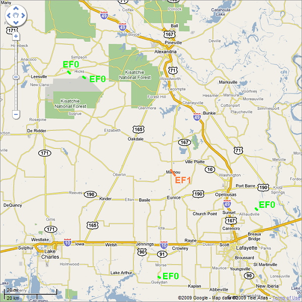
Arnaudville Tornado |
| DATE: 9/12/08 |
| TIME: 630 AM |
| PARISH: St. Landry |
| RATING: EF0 |
| PATH LENGTH: 1/4 mile |
| PATH WIDTH: 10 yards |
| DAMAGE: A tornado briefly touched down in the fields northeast of Arnaudville, causing no damage. |
|
Mamou Tornado |
| DATE: 9/12/08 |
| TIME: 425 PM |
| PARISH: Evangeline |
| RATING: EF2 |
| PATH LENGTH: 3 miles |
| PATH WIDTH: 20 yards |
| DAMAGE: A tornado touched down on the southeastern outskirts of Mamou, and damaged 10 to 15 homes near Highway 95 and Fred Street. One home lost its roof. One mobile home was flipped onto the highway. The tornado then skipped northwestward across Mamou, crossing Highway 13 before dissipating. |
|
Gueydan Tornado |
| DATE: 9/3/08 |
| TIME: 441 PM |
| PARISH: Vermilion |
| RATING: EF0 |
| PATH LENGTH: 1/4 mile |
| PATH WIDTH: 10 yards |
| DAMAGE: A tornado briefly touched down near Gueydan in a field, doing no damage. |
|
Hicks Tornado |
| DATE: 9/12/08 |
| TIME: 506 PM |
| PARISH: Vernon |
| RATING: EF0 |
| PATH LENGTH: 3/4 mile |
| PATH WIDTH: 10 yards |
| DAMAGE: Ham radio operators reported a tornado touch down with no damage. |
|
Slagle Tornado |
| DATE: 9/12/08 |
| TIME: 510 PM |
| PARISH: Vernon |
| RATING: EF0 |
| PATH LENGTH: 3/4 mile |
| PATH WIDTH: 10 yards |
| DAMAGE: Ham radio operators saw a tornado briefly touch down, producing no damage. |
Forecasts
Graphical Forecasts
Wet Bulb Globe Temps
Aviation Weather
Activity Planner
Mardi Gras Decision Support
Marine Forecasts
Local Products
Model Data
Forecaster's Discussion
Fire Weather
Other Links
National Hurricane Ctr
Storm Prediction Ctr
Weather Prediction Ctr
Other Links
Office History
LCH StoryMap
Hazards
Severe Weather
Tropical Weather
National Outlooks
Local Storm Reports
Tropical Cyclone Reports
Current
Satellite Data
Observations
Tide Data
Hydrology
Calcasieu Par. Network
Jefferson Co. DD6 Network
River/Lake Forecasts
Radar
Shreveport (SHV)
New Orleans (LIX)
Fort Polk (POE)
Houston/Galveston (HGX)
Lake Charles (LCH)
Probabilistic Pages
Probabilistic Snowfall
Probabilistic Rainfall
Probabilistic DSS
US Dept of Commerce
National Oceanic and Atmospheric Administration
National Weather Service
Lake Charles, LA
500 Airport Boulevard
Lake Charles, LA 70607
(337) 477-5285 M-F 8a to 4p only
Comments? Questions? Please Contact Us.

