Satellite Analysis of the 05-06 June 1998
Severe Weather Event
David S. Wally
National Weather Service Office
Lake Charles, Louisiana*
A line of severe thunderstorms developed across Southeast Texas on the afternoon of 05 June 1998. The trigger was an unseasonably strong cold front for late spring that moved quickly eastward and into the Lake Charles County Warning Area (CWA) by early evening.
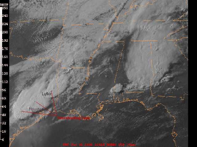
The GOES-8 visible image (Figure 1) from 22:45 UTC (Coordinated Universal Time) shows this squall line oriented from near Lufkin to southwest of Houston. Notice the overshooting tops throughout the complex; a good indicator that these storms were severe. At the time of this image, these storms were in the County Warning Areas of both the National Weather Service offices in Houston and Shreveport. Local storm reports from these offices indicated severe hail (greater than or equal to 3/4 inch in diameter) and wind damage shortly before and after this image.
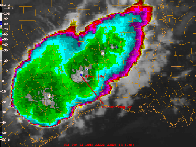
The GOES-8 10.7 micron longwave IR image (Figure 2) at 23:32 UTC indicated an overshooting cloud top temperature of -80 degrees Celsius (denoted by the isolated blue pixel) over West-Central Tyler county in Southeast Texas. Using the 00:00 UTC, 06 June 1998 Lake Charles atmospheric sounding, this correlated to a storm top of 65 thousand feet. Twenty one minutes prior to this image at 6:11 p.m. LDT (Local Daylight Time) or 23:11 UTC, the National Weather Service Office in Lake Charles detected a severe thunderstorm on Doppler Radar and issued a severe thunderstorm warning for Tyler county. A local storm report from the sheriff's office indicated hail 3/4 inch in diameter fell 1 mile Northwest of Woodville in central Tyler county at 6:30 p.m. LDT or 23:30 UTC. The time of this report correlated well with the time of the image.
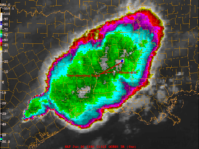
Later that evening, the GOES-8 10.7 micron longwave IR (Figure 3) at 01:02 UTC indicated another overshooting top over North-Central Rapides parish. The cloud top temperature was also near -80 degrees Celsius. Thirty three minutes prior to this image at 7:29 p.m. LDT or 00:29 UTC, the National Weather Service Office in Lake Charles detected another severe storm on Doppler Radar and issued a severe thunderstorm warning for Rapides parish. The following were storm reports received from the parish 911 emergency center leading up to the time of this image:
1. 7:32 p.m. LDT or 00:32 UTC - wind damage with a roof blown off in the Boyce Cotile area (15 miles northwest of Alexandria).
2. 7:45 p.m. LDT or 00:45 UTC - wind damage with a roof blown off in Alexandria.
3. 7:47 p.m. LDT or 00:47 UTC - wind damage with a roof blow off in Pineville (5 miles north of Alexandria).
In addition, numerous newspaper articles with unconfirmed times indicated widespread damage across Rapides parish. The hardest hit area was the Gardner community, including the Kincaid Lake and Cotile areas. Kincaid Lake Recreation Area closed for the summer with an estimated $250,000 in damage. The storm knocked power out to 10,000 residents with numerous trees toppled on power lines and roadways.
* Author's Current Affiliation: NWS's National Centers for Environmental Prediction - Hydrometeorological Prediction Center, Camp Springs MD
|