Louisville, KY
Weather Forecast Office
The middle of July was a rather active week as a large area of high pressure across the southern United States allowed areas of low pressure to ride around it into the Ohio Valley. These multiple areas of low pressure each produced thunderstorm complexes which pushed southeast through the region over the past week. These thunderstorm complexes each produced rounds of flash flooding, straight-line damaging winds, and even a few tornadoes at the sped across southern Indiana and Kentucky.
Flash Flooding
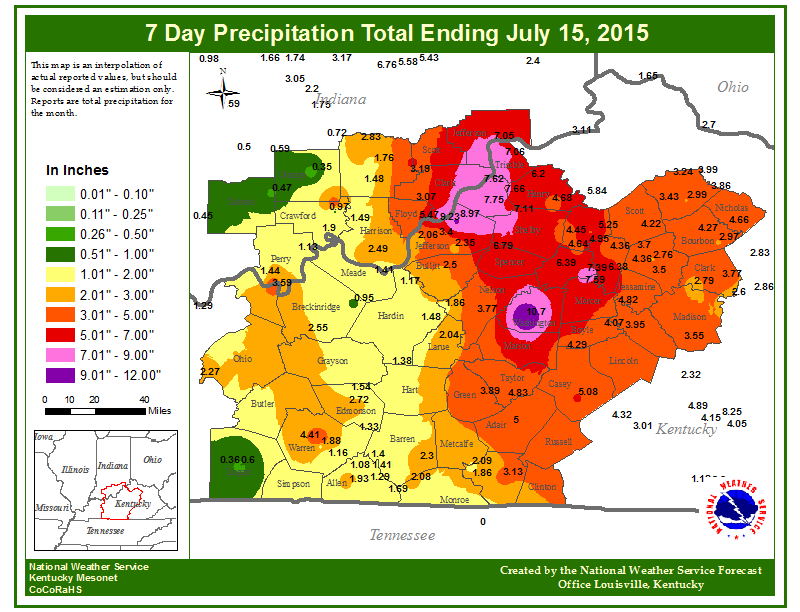
Each round of thunderstorms brought very heavy rainfall to the region, especially across southern Indiana and central Kentucky. These repeated rounds of torrential rainfall lead to rather widespread flash flooding, especially Monday night into Tuesday morning (July 13th into July 14th).
Below is a map of the rainfall totals from this week. Notice some of the rainfall totals in excess of 10 inches, in just 7 days!
Below are some pictures of Flash Flooding that occurred early on July 12th. The pictures were taken in Louisville and in New Albany and Austin, IN. The picture on the bottom left was taken on July 14th in Louisville. Click on the picture to enlarge.


Damaging Winds
Below are images of the damaging wind reports for each day. The Ohio River Valley experienced several reports on 7/9, and 7/10, but were especially hard hit on 7/13, and 7/14. Click on any image to enlarge it.


Tornadoes
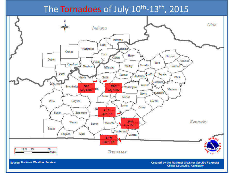
Although they were not widespread, a few tornadoes developed in some of the thunderstorm complexes. Below are the locations of the tornadoes, along with some pictures of the damage they produced.
Current Hazards
Hazardous Weather Outlook
Storm Prediction Center
Submit a Storm Report
Advisory/Warning Criteria
Radar
Fort Knox
Evansville
Fort Campbell
Nashville
Jackson
Wilmington
Latest Forecasts
El Nino and La Nina
Climate Prediction
Central U.S. Weather Stories
1-Stop Winter Forecast
Aviation
Spot Request
Air Quality
Fire Weather
Recreation Forecasts
1-Stop Drought
Event Ready
1-Stop Severe Forecast
Past Weather
Climate Graphs
1-Stop Climate
CoCoRaHS
Local Climate Pages
Tornado History
Past Derby/Oaks/Thunder Weather
Football Weather
Local Information
About the NWS
Forecast Discussion
Items of Interest
Spotter Training
Regional Weather Map
Decision Support Page
Text Products
Science and Technology
Outreach
LMK Warning Area
About Our Office
Station History
Hazardous Weather Outlook
Local Climate Page
Tornado Machine Plans
Weather Enterprise Resources
US Dept of Commerce
National Oceanic and Atmospheric Administration
National Weather Service
Louisville, KY
6201 Theiler Lane
Louisville, KY 40229-1476
502-969-8842
Comments? Questions? Please Contact Us.


 Weather Story
 Weather Map
 Local Radar