Louisville, KY
Weather Forecast Office
The National Weather Service in Louisville is happy to announce a new on-line archive of daily precipitation, maximum and minimum temperature, and snow depths for many stations in Kentucky and southern Indiana. The data shows accumulation or current values at 7 AM. The data sources are varied: airport, Kentucky Mesonet, cooperative, CoCoRaHS, satellite, IFLOWS, and MSD precipitation. Below is a screenshot of what the page looks like:
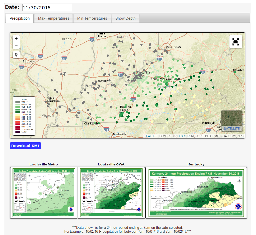
Precipitation data is in two forms; KML format which can be downloaded, or PNG format. All other data is in KML format. To find out details about a particular point, simply click on the point and a box with more information will pop up. Clicking on the large thumbnails at the bottom will cause the images to enlarge. The archive goes back to 2015 for now and may extend back to 2014 soon. However, there are some dates which are not available.
One thing to note is that precipitation and temperature data are for a 24 hour period ending in the morning. Thus, there might be a day shift when comparing this data to calendar day data. For example, if heavy rain fell at an airport in the afternoon of the 10th, the calendar day records would record the rain on the 10th, but this archive would show it on the 11th. Snow Depth data is also the observed depth seen that morning. The reason for this is that calendar day data is not available for cooperative or CoCoRaHS stations.
The National Weather Service in Louisville hopes you find this archive useful. Do you want your location to appear on these maps? Join CoCoRaHS and see your data displayed!
Current Hazards
Hazardous Weather Outlook
Storm Prediction Center
Submit a Storm Report
Advisory/Warning Criteria
Radar
Fort Knox
Evansville
Fort Campbell
Nashville
Jackson
Wilmington
Latest Forecasts
El Nino and La Nina
Climate Prediction
Central U.S. Weather Stories
1-Stop Winter Forecast
Aviation
Spot Request
Air Quality
Fire Weather
Recreation Forecasts
1-Stop Drought
Event Ready
1-Stop Severe Forecast
Past Weather
Climate Graphs
1-Stop Climate
CoCoRaHS
Local Climate Pages
Tornado History
Past Derby/Oaks/Thunder Weather
Football Weather
Local Information
About the NWS
Forecast Discussion
Items of Interest
Spotter Training
Regional Weather Map
Decision Support Page
Text Products
Science and Technology
Outreach
LMK Warning Area
About Our Office
Station History
Hazardous Weather Outlook
Local Climate Page
Tornado Machine Plans
Weather Enterprise Resources
US Dept of Commerce
National Oceanic and Atmospheric Administration
National Weather Service
Louisville, KY
6201 Theiler Lane
Louisville, KY 40229-1476
502-969-8842
Comments? Questions? Please Contact Us.


 Weather Story
 Weather Map
 Local Radar