Louisville, KY
Weather Forecast Office
A Frost Advisory is in effect for part of the area for Thursday morning. We would really love to see what kind of frost you experience around your house. You can either post your pic to our Facebook account (https://www.facebook.com/NWSLouisville/), Twitter account (@NWSLouisville, or https://twitter.com/NWSLouisville), or send an e-mail to here. A frost advisory is issued when widespread frost is expected on area vegetation and grasses, not just roof tops and cars, where frost can occur at slightly warmer temperatures.

Here is a picture of frost flowers, an interesting feature that can form in tall weeds/grasses on cold mornings.
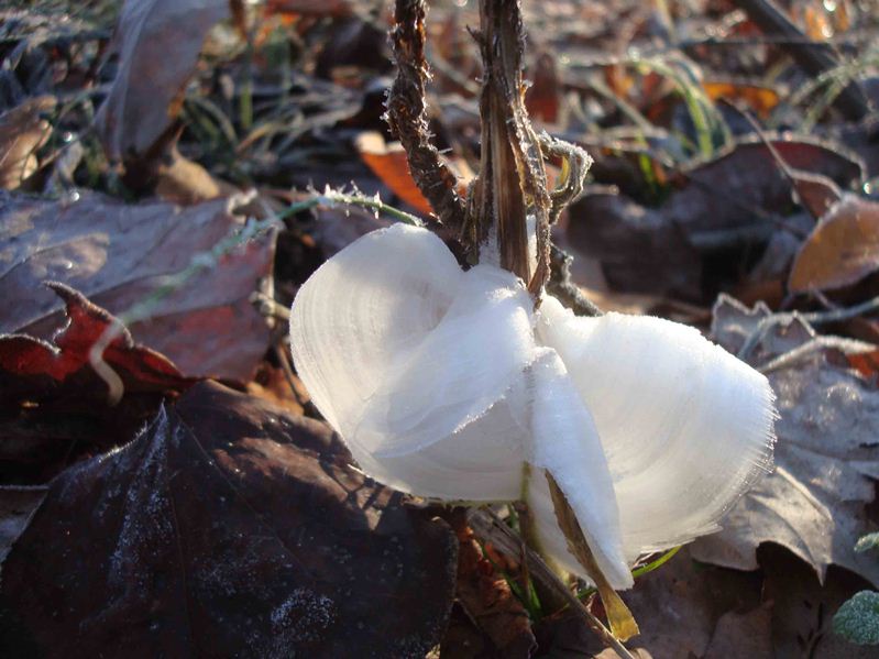
For more information on frost flowers, check out this web page, https://www.weather.gov/lmk/frost_flowers.
Of course, sometimes car tops can have cool patterns worthy of photos as well, as in this picture.

For more of these type pictures, check out this article, https://www.weather.gov/lmk/UnusualCarTopFrostThisMorning
Current Hazards
Hazardous Weather Outlook
Storm Prediction Center
Submit a Storm Report
Advisory/Warning Criteria
Radar
Fort Knox
Evansville
Fort Campbell
Nashville
Jackson
Wilmington
Latest Forecasts
El Nino and La Nina
Climate Prediction
Central U.S. Weather Stories
1-Stop Winter Forecast
Aviation
Spot Request
Air Quality
Fire Weather
Recreation Forecasts
1-Stop Drought
Event Ready
1-Stop Severe Forecast
Past Weather
Climate Graphs
1-Stop Climate
CoCoRaHS
Local Climate Pages
Tornado History
Past Derby/Oaks/Thunder Weather
Football Weather
Local Information
About the NWS
Forecast Discussion
Items of Interest
Spotter Training
Regional Weather Map
Decision Support Page
Text Products
Science and Technology
Outreach
LMK Warning Area
About Our Office
Station History
Hazardous Weather Outlook
Local Climate Page
Tornado Machine Plans
Weather Enterprise Resources
US Dept of Commerce
National Oceanic and Atmospheric Administration
National Weather Service
Louisville, KY
6201 Theiler Lane
Louisville, KY 40229-1476
502-969-8842
Comments? Questions? Please Contact Us.


 Weather Story
 Weather Map
 Local Radar