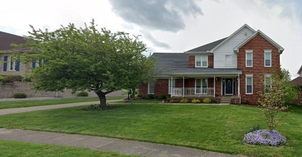
There was only one outbreak of severe weather this April in the middle Ohio Valley, but it was a significant one. On the evening of the 13th a strong cold front sparked severe storms from Texas to Ohio. Three main corridors of rough weather formed: one from northern Louisiana to central Alabama, one from Arkansas to Tennessee, and one from the northeast corner of Arkansas to northeast Kentucky. Fourteen tornadoes spun up in Kentucky between 5pm CDT and 9pm EDT. Nine of those were in central Kentucky and all nine occurred in a span of 43 minutes between 8:13 and 8:56pm EDT. The most impactful was an EF-1 that was on the ground for over seven miles in southern Louisville and damaged several homes. The Louisville tornado touched down just 1.25 miles from the NWS office. The NWS office's anemometer recorded a 72mph wind gust, resulting in some damage to a fence.
On the other end of the spectrum, we also had two snowfall events, though they were both minor. On April 1 lingering moisture behind a departing cold front caused some flurries to fall across southern Indiana and north central Kentucky. Then from the night of the 8th into the morning of the 9th a weak trough brought another round of flurries to much of the region, even down into Tennessee.
| Average Temperature | Departure from Normal | Precipitation | Departure from Normal | Snow | Departure from Normal | |
| Bowling Green | 57.5° | -1.5° | 4.51" | -0.30" | 0 | -0.1" |
| Frankfort | 54.4° | -2.3° | 3.77" | -0.78" | ||
| Lexington | 55.1° | -1.1° | 3.71" | -0.71" | T | -0.2" |
| Louisville Ali | 57.1° | -1.9° | 4.44" | -0.36" | T | -0.1" |
| Louisville Bowman | 55.6° | -2.5° | 4.36" | -0.33" |
Records
No records were set this month
|
|
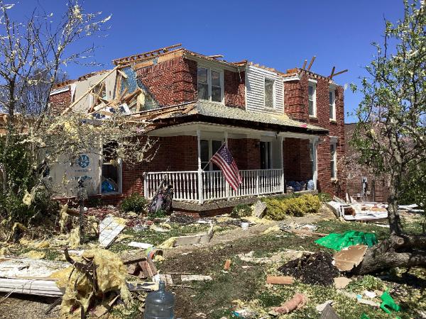 |
Before and after an EF-1 tornado struck southern Louisville on April 13. Left: Google, Right: NWS storm survey


 Weather Story
 Weather Map
 Local Radar