Although April can be a very stormy month in the Ohio Valley, this April there was only one severe weather event in southern Indiana/central Kentucky. It took place on the 8th when two areas of thunderstorms affected the area. One was a cluster of severe storms that produced large hail as it moved from southeast Missouri into western and south central Kentucky. The other was a powerful squall line that caused damaging winds to sweep from central Illinois to North Carolina. Many reports of wind damage were received from southern Indiana and north central Kentucky. There was one small tornado spin-up just north of Bardstown.
The lack of severe weather was largely due to the dominance of cool air flowing out of Canada. Twenty-one days of the month were colder than normal at Lexington. There were 20 such days for Louisville and 19 in Bowling Green. The coldest air of the month hit on the 15th-16th taking the mercury well down into the 20s in many locations. Young leaves on deciduous trees were damaged, and damage to winter wheat, alfalfa, and fruit crops was reported. There were even a few flurries in Lexington and Bowling Green on the 14th.
| Average Temperature | Departure from Normal | Precipitation | Departure from Normal | Snow | Departure from Normal | |
| Bowling Green | 55.9° | -1.8° | 4.19" | -0.15" | T | -0.2" |
| Frankfort | 52.7° | -2.5° | 5.04" | +1.35" | ||
| Lexington | 50.9° | -4.4° | 4.92" | +1.32" | T | -0.3" |
| Louisville Bowman | 54.5° | -2.6° | 4.36" | +0.28" | ||
| Louisville Ali | 55.9° | -2.1° | 4.08" | +0.07" | 0 | -0.1" |
Records
8th: High of 85° at Louisville
15th: Low of 25° at Frankfort, low of 25° at Lexington, low of 30° at Louisville
16th: Low of 24° at Frankfort
25th: Rainfall of 1.37" at Bowling Green
27th: Low of 32° at Lexington
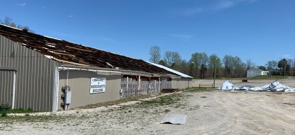
Straightline wind damage between La Grange and Pendleton on the 8th. NWS


 Weather Story
 Weather Map
 Local Radar