
Tropical moisture from Isaias and Rachel will impact portions of the Southeast and Southwest this weekend. Flash flooding, strong winds and even a threat for severe thunderstorms and tornadoes are possible. Meanwhile, strong winds and dry fuels are raising fire weather concerns across the central Great Basin and western High Plains. Across the northern Rockies, first winter storm of the season. Read More >
Louisville, KY
Weather Forecast Office
There were two major storm systems to affect the region during December 2023. The first was on a 9th when severe storms developed ahead of a cold front. A long-track EF-3 tornado touched down near Clarksville, TN and stayed on the ground for 48 miles into central Kentucky southwest of Bowling Green. Small, brief EF-1 tornadoes touched down on Bowling Green's south side and south of Tompkinsville. There was almost no other severe weather in central Kentucky outside of these three tornadoes.
The other significant event of the month took place on the 18th when cold air and an unstable atmosphere resulted in widespread snow showers and a few snow squalls. Frankfort experienced a snow squall that reduced visibility to 1/4 mile in heavy snow with winds gusting to 42 mph. Another squall crossed Interstate 75 in Madison County and briefly reduced visibility to near zero.
| Average Temperature | Departure from Normal | Precipitation | Departure from Normal | Snow | Departure from Normal | |
| Bowling Green | 44.3° | +3.8° | 2.15" | -2.20" | 0 | -0.8" |
| Frankfort | 42.0° | +3.9° | 2.07" | -1.70" | ||
| Lexington | 43.9° | +6.1° | 2.44" | -1.76" | T | -1.9" |
| Louisville Ali | 45.1° | +5.5° | 1.86" | -2.27" | 0.1" | -2.1" |
| Louisville Bowman | 42.6° | +3.8° | 1.77" | -2.11" |
Records
9th warmest December on record at Lexington and Louisville
10th warmest December on record at Frankfort
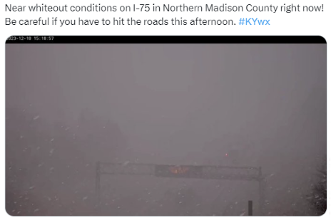
Dangerous conditions along I-75 on the 18th.
Current Hazards
Hazardous Weather Outlook
Storm Prediction Center
Submit a Storm Report
Advisory/Warning Criteria
Radar
Fort Knox
Evansville
Fort Campbell
Nashville
Jackson
Wilmington
Latest Forecasts
El Nino and La Nina
Climate Prediction
Central U.S. Weather Stories
1-Stop Winter Forecast
Aviation
IDSS Forecast Points
Air Quality
Fire Weather
Recreation Forecasts
1-Stop Drought
Event Ready
1-Stop Severe Forecast
Past Weather
Climate Graphs
1-Stop Climate
CoCoRaHS
Local Climate Pages
Tornado History
Past Derby/Oaks/Thunder Weather
Football Weather
Local Information
About the NWS
Forecast Discussion
Items of Interest
Spotter Training
Regional Weather Map
Decision Support Page
Text Products
Science and Technology
Outreach
LMK Warning Area
About Our Office
Station History
Hazardous Weather Outlook
Local Climate Page
Tornado Machine Plans
Weather Enterprise Resources

US Dept of Commerce
National Oceanic and Atmospheric Administration
National Weather Service
Louisville, KY
6201 Theiler Lane
Louisville, KY 40229-1476
502-969-8842
Comments? Questions? Please Contact Us.


 Weather Story
 Weather Map
 Local Radar
 Follow us on X
 Follow us on Facebook
 Follow us on YouTube
 LMK RSS Feed