Louisville, KY
Weather Forecast Office
July 2023 was a very active month with severe storms occurring somewhere in southern Indiana or central Kentucky on eight different days.
A cold front approached the region on the afternoon of the 2nd. Ahead of the front, a moist and unstable airmass combined with fairly strong wind shear aloft for the time of year. Numerous thunderstorms developed, including some supercells. EF- 1 tornadoes touched down in Anderson County and Casey County, and there were numerous wind damage reports across the area. A few instances of large hail up to the size of golf balls were also reported.
Around midnight on the night of the 17th a hailstorm produced stones to the size of ping pong balls in Louisville.
Several Flash Flood Warnings were issued during the month as well. Shortly after midnight on the 28th heavy rains caused flash flooding on Hooktown Branch in northwestern Nicholas County that resulted in a fatality when the stream swept a home off of its foundation.
| Average Temperature | Departure from Normal | Precipitation | Departure from Normal | |
| Bowling Green | 80.0° | +0.3° | 5.12" | +0.86" |
| Frankfort | 76.6° | -0.6° | 3.67" | -1.02" |
| Lexington | 78.2° | +1.5° | 5.32" | +0.20" |
| Louisville Ali | 80.5° | +0.6° | 3.77" | -0.28" |
| Louisville Bowman | 78.1° | -0.5° | 3.07" | -1.49" |
Records
13th: Record warm low of 78° at Bowling Green
26th: Record warm low of 76° at Bowling Green
27th: Record warm low of 78° at Bowling Green, record warm low of 76° at Frankfort, record warm low of 77° at Lexington, record warm low of 80° at Louisville
28th: Record warm low of 82° at Louisville
29th: Record warm low of 77° at Lexington
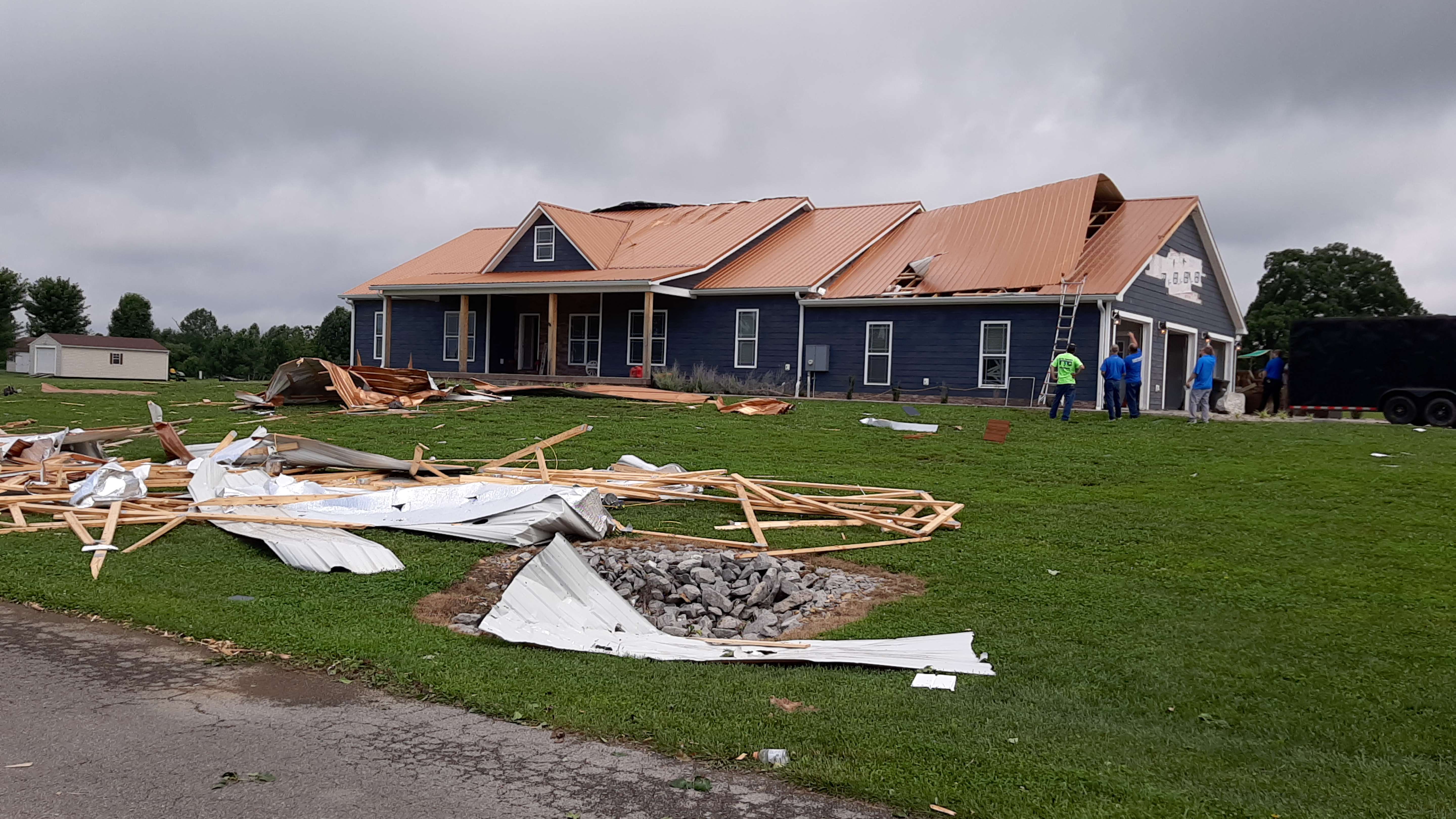
Tornado damage in Casey County on the 2nd. NWS Storm Survey
Current Hazards
Hazardous Weather Outlook
Storm Prediction Center
Submit a Storm Report
Advisory/Warning Criteria
Radar
Fort Knox
Evansville
Fort Campbell
Nashville
Jackson
Wilmington
Latest Forecasts
El Nino and La Nina
Climate Prediction
Central U.S. Weather Stories
1-Stop Winter Forecast
Aviation
IDSS Forecast Points
Air Quality
Fire Weather
Recreation Forecasts
1-Stop Drought
Event Ready
1-Stop Severe Forecast
Past Weather
Climate Graphs
1-Stop Climate
CoCoRaHS
Local Climate Pages
Tornado History
Past Derby/Oaks/Thunder Weather
Football Weather
Local Information
About the NWS
Forecast Discussion
Items of Interest
Spotter Training
Regional Weather Map
Decision Support Page
Text Products
Science and Technology
Outreach
LMK Warning Area
About Our Office
Station History
Hazardous Weather Outlook
Local Climate Page
Tornado Machine Plans
Weather Enterprise Resources
US Dept of Commerce
National Oceanic and Atmospheric Administration
National Weather Service
Louisville, KY
6201 Theiler Lane
Louisville, KY 40229-1476
502-969-8842
Comments? Questions? Please Contact Us.


 Weather Story
 Weather Map
 Local Radar