The month started off with a bang as a series of strong storms moved into the lower Ohio River Valley and Tennessee Valley late on the evening of March 2 into the early morning hours of of the third. Along with large hail, and some flash flooding, one particular storm produced a brief tornado near Alvaton. Much stronger tornadoes ravaged middle Tennessee, including an EF-3 in Nashville and an EF-4 near Cookeville.
About a week and a half later, on the 12th, powerful storms moved all the way from the St. Louis area to the Lake Cumberland region, producing a swath of gusty winds and large hail.
Low pressure coming in from the west, riding along a stationary front draped from Kansas to West Virginia, sparked widespread showers and thunderstorms on the 19th, including some strong storms in southern Indiana that knocked down a few trees.
The most widespread severe weather event of the month took place from the evening of the 28th into the early morning of the 29th. Widespread showers and thunderstorms caused several instances of wind damage around central Kentucky and southern Indiana. Things were worse to our west where EF-2 tornadoes struck Henderson, KY, and Newburgh, IN.
| Average Temperature | Departure from Normal | Precipitation | Departure from Normal | Snowfall | Departure from Normal | |
| Bowling Green | 53.9° | +5.5° | 8.38" | +3.97" | 0 | -1.1" |
| Frankfort | 51.3° | +6.4° | 4.60" | +0.22" | ||
| Lexington | 49.7° | +4.2° | 4.96" | +0.89" | T | -1.4" |
| Louisville Bowman | 52.2° | +5.2° | 5.09" | +0.93" | ||
| Louisville Ali | 53.3° | +5.5° | 4.69" | +0.52" | T | -1.4" |
Records
12th: Rainfall of 1.49" at Frankfort
19th: Warm low of 60° at Lexington, warm low of 61° at Louisville
27th: Warm low of 64° at Bowling Green
28th: Warm low of 65° at Bowling Green
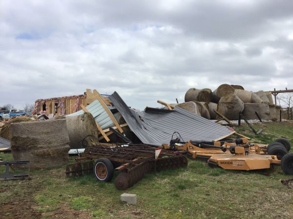
Alvaton, Kentucky, on the 3rd. NWS


 Weather Story
 Weather Map
 Local Radar