Louisville, KY
Weather Forecast Office
Though we had storms in the area on the days leading up to the Kentucky Derby, the actual day of the Derby itself was cool and cloudy with some patchy light rain, especially in the morning. The afternoon high of 64 was the coolest since 2017 when we saw a high of only 62.
After Derby we entered a dry and very warm spell from the 8th to the 13th, with afternoon temperatures in the 80s to around 90.
Although we had occasional stormy days throughout the month, as is typical for May in this area, the most unsettled part of the month was from the 14th to the 26th. On the 18th a powerful thunderstorm generated impressive 97 mph winds in southern Marion County, resulting in significant damage between Lebanon and the Taylor County line. The next day numerous storms produced damaging wind and huge hail throughout southern Indiana and north central Kentucky, including hail at least as big as baseballs striking the counties of Mercer, Jessamine, Fayette, and Harrison KY. Finally on the 26th thunderstorm winds gusting to 85 mph buffeted southeastern Adair County resulting in much tree damage.
Despite the active weather, parts of the area, especially southern Kentucky and the Louisville metro, were starting to show signs of dryness.
| Average Temperature | Departure from Normal | Precipitation | Departure from Normal | |
| Bowling Green | 70.5° | +2.5° | 3.93" | -1.10" |
| Frankfort | 68.1° | +2.6° | 5.36" | +0.26" |
| Lexington | 68.7° | +3.3° | 3.84" | -1.60" |
| Louisville Ali | 70.9° | +2.6° | 3.23" | -1.95" |
| Louisville Bowman | 69.6° | +2.4° | 3.73" | -1.43" |
Records
20th: Warm low of 73° at Bowling Green, warm low of 71° at Lexington, record high of 91° at Louisville, warm low of 76° at Louisville (tied record warm low for the month of May)
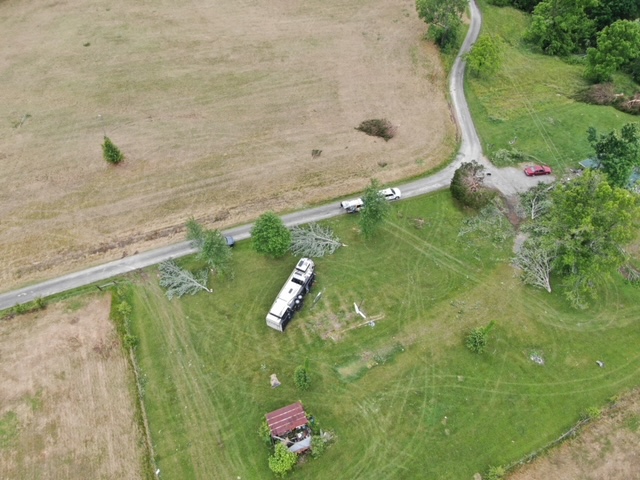
Trees and a mobile home toppled by 80 mph winds in Adair County on the 26th. NWS drone survey
Current Hazards
Hazardous Weather Outlook
Storm Prediction Center
Submit a Storm Report
Advisory/Warning Criteria
Radar
Fort Knox
Evansville
Fort Campbell
Nashville
Jackson
Wilmington
Latest Forecasts
El Nino and La Nina
Climate Prediction
Central U.S. Weather Stories
1-Stop Winter Forecast
Aviation
IDSS Forecast Points
Air Quality
Fire Weather
Recreation Forecasts
1-Stop Drought
Event Ready
1-Stop Severe Forecast
Past Weather
Climate Graphs
1-Stop Climate
CoCoRaHS
Local Climate Pages
Tornado History
Past Derby/Oaks/Thunder Weather
Football Weather
Local Information
About the NWS
Forecast Discussion
Items of Interest
Spotter Training
Regional Weather Map
Decision Support Page
Text Products
Science and Technology
Outreach
LMK Warning Area
About Our Office
Station History
Hazardous Weather Outlook
Local Climate Page
Tornado Machine Plans
Weather Enterprise Resources
US Dept of Commerce
National Oceanic and Atmospheric Administration
National Weather Service
Louisville, KY
6201 Theiler Lane
Louisville, KY 40229-1476
502-969-8842
Comments? Questions? Please Contact Us.


 Weather Story
 Weather Map
 Local Radar