Louisville, KY
Weather Forecast Office
 |
|
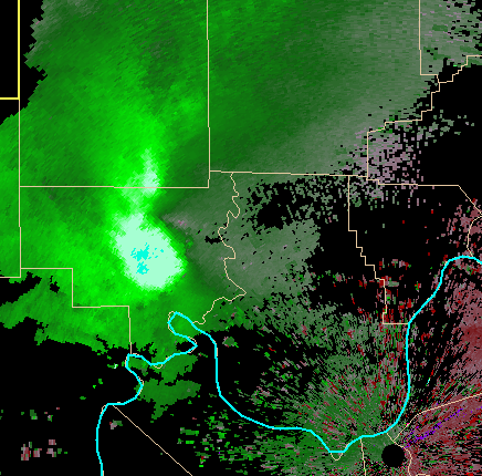
NWS Doppler Radar calculates atmospheric motion based on cloud and precipitation movements. Using the "Doppler effect," it senses targets moving toward and away from the radar parallel to radar beams (radial velocity). It cannot sense motion directed perpendicular to a beam since there is no phase shift in the Doppler effect for such movement. Two types of velocity are available: 1) base velocity which shows movement with respect to the ground (estimated actual environmental wind), and 2) storm-relative velocity map (SRM), which shows movement relative to a moving target, e.g., wind a thunderstorm "feels" as it moves through its environment. Above is base velocity data over Crawford County in southern Indiana on August 13, 2011 (west of Louisville). The blue line is the Ohio River. Green colors are winds directed toward the radar site at Ft. Knox, KY (black circle at lower right). The light blue color within the bright green and white colors in Crawford County represent estimated winds of 60-70 kts only a couple thousand feet off the ground. These intense winds are associated with a bow echo in reflectivity data, and where strong winds and/or wind damage would be located. As the winds moved east, wind damage occurred along its path in Crawford and Harrison counties in southern Indiana, then across Jefferson County (and Louisville), Kentucky where Bowman Field Airport (LOU) reported a 69 mph wind gust. More information on this August 13, 2011 event, including damage photos and radar imagery is available on our Science and Tech site. |
Current Hazards
Hazardous Weather Outlook
Storm Prediction Center
Submit a Storm Report
Advisory/Warning Criteria
Radar
Fort Knox
Evansville
Fort Campbell
Nashville
Jackson
Wilmington
Latest Forecasts
El Nino and La Nina
Climate Prediction
Central U.S. Weather Stories
1-Stop Winter Forecast
Aviation
IDSS Forecast Points
Air Quality
Fire Weather
Recreation Forecasts
1-Stop Drought
Event Ready
1-Stop Severe Forecast
Past Weather
Climate Graphs
1-Stop Climate
CoCoRaHS
Local Climate Pages
Tornado History
Past Derby/Oaks/Thunder Weather
Football Weather
Local Information
About the NWS
Forecast Discussion
Items of Interest
Spotter Training
Regional Weather Map
Decision Support Page
Text Products
Science and Technology
Outreach
LMK Warning Area
About Our Office
Station History
Hazardous Weather Outlook
Local Climate Page
Tornado Machine Plans
Weather Enterprise Resources

US Dept of Commerce
National Oceanic and Atmospheric Administration
National Weather Service
Louisville, KY
6201 Theiler Lane
Louisville, KY 40229-1476
502-969-8842
Comments? Questions? Please Contact Us.


 Weather Story
 Weather Map
 Local Radar
 Follow us on X
 Follow us on Facebook
 Follow us on YouTube
 LMK RSS Feed