Louisville, KY
Weather Forecast Office
Winter 2021-22 turned out to be one of our busiest winters in several years. It started with a couple of small tornadoes near Frankfort on December 6, followed less than a week later by the historic December 10-11 tornado outbreak that included a high-end EF-3 twister tearing directly through Bowling Green. The remainder of December was quieter, but we had our warmest Christmas on record with temperatures in the 70s.
2022 started with a bang as we endured a New Year's Day tornado event along with flooding rains. It was the warmest and wettest January 1 on record at several locations. This was followed just several days later by frigid cold and heavy snow, including over half a foot at Bowling Green and nearly ten inches at Lexington. Cold temperatures set in for the remainder of the month and it was Lexington's coldest January since 2014.
February was characterized by several rainy systems, one after another, leading to minor flooding. Wintry weather wasn't widespread, but we did have some snow and ice, particularly on the 3rd-4th and 24th. A strong winter system on the 17th brought us 50-60mph winds!
| Average Temperature | Departure from Normal | Precipitation | Departure from Normal | Snow | Departure from Normal | |
| Bowling Green | 41.8° | +2.2° | 15.27" | +3.21" | 10.4" | |
| Frankfort | 38.8° | +2.2° | 15.81" | +5.37" | ||
| Lexington | 37.7° | +1.3° | 17.53" | +6.27" | 18.4" | +7.3" |
| Louisville Ali | 40.7° | +2.5° | 14.99" | +4.06" | 8.0" | -2.8" |
| Louisville Bowman | 39.7° | +2.3° | 14.63" | +4.20" |
Records
5th wettest winter on record at Lexington
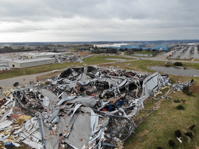
Destruction on the north side of Bowling Green December 11. NWS drone
Current Hazards
Hazardous Weather Outlook
Storm Prediction Center
Submit a Storm Report
Advisory/Warning Criteria
Radar
Fort Knox
Evansville
Fort Campbell
Nashville
Jackson
Wilmington
Latest Forecasts
El Nino and La Nina
Climate Prediction
Central U.S. Weather Stories
1-Stop Winter Forecast
Aviation
IDSS Forecast Points
Air Quality
Fire Weather
Recreation Forecasts
1-Stop Drought
Event Ready
1-Stop Severe Forecast
Past Weather
Climate Graphs
1-Stop Climate
CoCoRaHS
Local Climate Pages
Tornado History
Past Derby/Oaks/Thunder Weather
Football Weather
Local Information
About the NWS
Forecast Discussion
Items of Interest
Spotter Training
Regional Weather Map
Decision Support Page
Text Products
Science and Technology
Outreach
LMK Warning Area
About Our Office
Station History
Hazardous Weather Outlook
Local Climate Page
Tornado Machine Plans
Weather Enterprise Resources
US Dept of Commerce
National Oceanic and Atmospheric Administration
National Weather Service
Louisville, KY
6201 Theiler Lane
Louisville, KY 40229-1476
502-969-8842
Comments? Questions? Please Contact Us.


 Weather Story
 Weather Map
 Local Radar