Overview
|
During the late evening of July 9th into the morning of July 10th, showers and thunderstorms blossomed across southeast Missouri and repeated over a relatively narrow corridor. The combination of the persistent thunderstorms and efficient rainfall rates resulted in a long swath of 6 to 10" of rain, with pockets of 12" observed. This extreme amount of rain within around 12 hours resulted in considerable to catastrophic flash flooding, particularly in portions of Iron and Reynolds Counties where a Flash Flood Emergency was issued. Numerous swift water rescues occurred across the affected area, the most notable being at Camp Taum Sauk where hundreds of campers and staff needed to be airlifted to safety. One fatality was confirmed in southern Crawford County. |
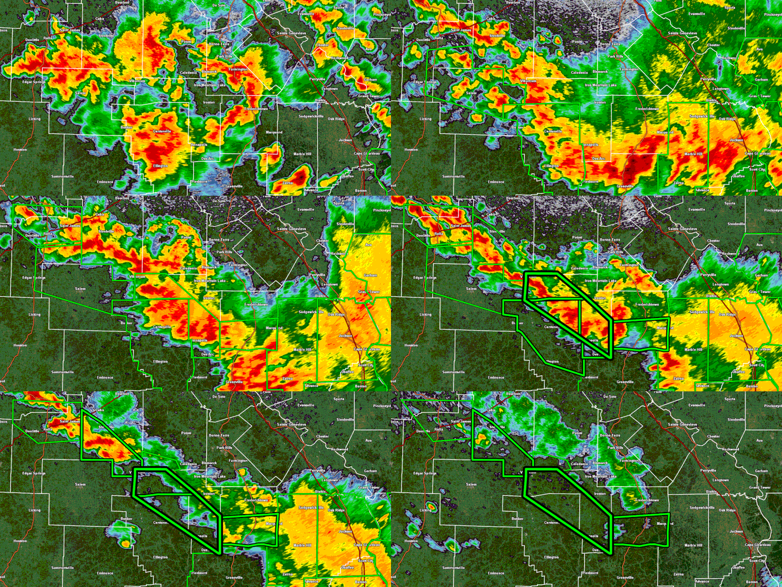 Radar reflectivity from KLSX (St. Louis) and Flash Flood Warnings between 11PM and 8AM on July 9-10, 2026. |
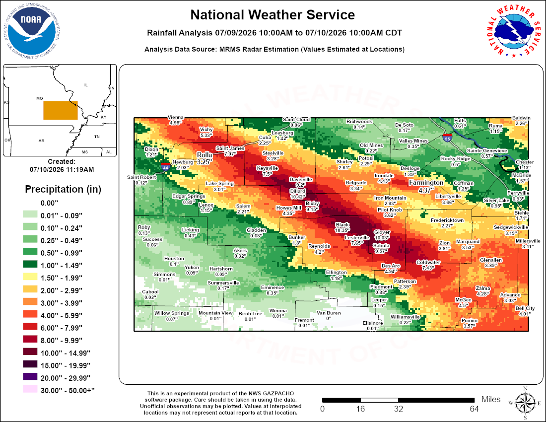 A corridor of 8 to 12" of rainfall stretched across Crawford, Iron, Reynolds, and Madison Counties. |
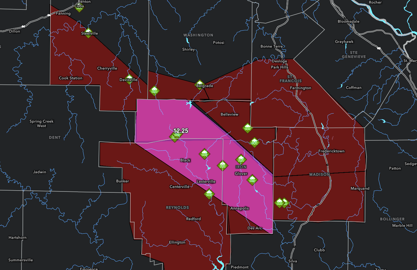 Flash Flood Warnings (red) issued by the NWS St. Louis Forecast Office for southeastern MO along with the Flash Flood Emergency (pink) for Iron and Reynolds Counties. Flash Flood Emergencies are reserved for exceedingly rare, life-threatening flash flooding as in this case. Locations of flash flood reports (green icons) and the 12.25" rainfall report are also shown. |
Meteorology & Climatological Context
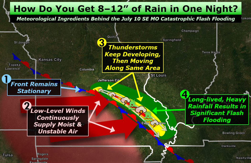 An illustration of the meteorological setup behind the event. |
From the late evening of July 9th through the morning of July 10th, a stationary front was draped through southeastern Missouri with westerly low-level winds continuously supplying moist and unstable air up and over the front. These two ingredients allowed thunderstorms to keep developing and subsequently move along the same area. These thunderstorms provided long-lived, heavy rainfall that resulted in significant flash flooding. This type of pattern is common among flash flood events. |
 |
 |
| Radar estimated hourly rainfall rates from 1 to 2 am on July 10. | Annual exceedance probabilities of the 24 hour rainfall. |
River Hydrographs
The axis of heaviest rain fell across the Black River and Meramec River basins, causing moderate to historic river flooding. The most significant flood impacts were found near these rivers.
 |
 |
 |
| The Black River near Annapolis crested at 28.73 ft in Major Flood Stage on July 10. This crest broke the all-time record by over a foot. Note that the river level rose over 20 ft in less than 12 hours. | The Meramec River near Steelville crested at 19.25 ft in Minor Flood Stage on July 10. | The Meramec River near Sullivan crested at 23.55 ft in Moderate Flood Stage on July 10. |
Photos
Iron County
 |
 |
 |
 |
| Flooding up to the foundation and front porch of a house. (source: Scott Oatman) |
Flood waters flowing across a street. (source: Scott Oatman) |
A closed road due to flooding. (source: Scott Oatman) |
Flooding across a bridge and an extend stretch of adjacent roadway. (source: Scott Oatman) |
 |
|||
| Remnants of flooding at an RV park where an RV and manufactured home were carried by flood waters. (source: Scott Oatman) |
Crawford County
 |
 |
 |
| A home damaged by fast-flowing flood waters. (source: MSHP) |
A home damaged by fast-flowing flood waters. (source: MSHP) |
Flooding at the Huzzah Valley Resort. (source: MSHP) |
Storm Reports
..TIME...   ...EVENT...      ...CITY LOCATION...     ...LAT.LON...
..DATE...   ....MAG....      ..COUNTY LOCATION..ST.. ...SOURCE....
            ..REMARKS..

0700 AM     Flash Flood      1 E Courtois            37.77N 91.07W
07/10/2026                   Washington         MO   Law Enforcement

            Water over Hwy C and Old Hwy C.

0751 AM     Flash Flood      1 WNW Belgrade          37.79N 90.87W
07/10/2026                   Washington         MO   Law Enforcement

            Route C closed just west of Belgrade, MO due
            to flood waters.

0230 AM     Flash Flood      3 S Lesterville         37.41N 90.83W
07/10/2026                   Reynolds           MO   911 Call Center

            Camp Taum Sauk began flooding around this
            time, stranding hundreds of children and
            staff members. The campers and staff were
            rescued by National Guard helicopters.

0257 AM     Flash Flood      5 ENE Black             37.55N 90.85W
07/10/2026                   Reynolds           MO   911 Call Center

            Flash flooding resulted in home being
            inundated and evacuation needed.

0400 AM     Flash Flood      3 WNW Saco              37.38N 90.50W
07/10/2026                   Madison            MO   911 Call Center

            C Charles Road closed in Jewett, MO. Time
            based on report from 911 center.

0550 AM     Flash Flood      4 WNW Saco              37.38N 90.52W
07/10/2026                   Madison            MO   Law Enforcement

            Route C near FF closed due to flood waters.

0323 AM     Flash Flood      1 SE Granite            37.64N 90.66W
07/10/2026                   Iron               MO   Public

            Report from mPING: Street/road flooding;
            Street/road closed; Vehicles stranded.

0347 AM     Flash Flood      4 W Hogan               37.51N 90.77W
07/10/2026                   Iron               MO   911 Call Center

            House flooded, evacuation required.

0441 AM     Flash Flood      1 NNE Hogan             37.53N 90.69W
07/10/2026                   Iron               MO   911 Call Center

            Home inundated with flood water, evacuation
            needed.

0449 AM     Flash Flood      4 NE Oates              37.61N 90.98W
07/10/2026                   Iron               MO   911 Call Center

            Home inundated with flood water, evacuation
            needed.

0512 AM     Flash Flood      Arcadia                 37.59N 90.63W
07/10/2026                   Iron               MO   Public

            Report from mPING: Homes or buildings filled
            with water.

0645 AM     Flash Flood      6 NE Oates              37.62N 90.97W
07/10/2026                   Iron               MO   Public

            Home underwater, abundant water over the
            roadway. Measured 12.25 inches of rain
            overnight nearby.

0650 AM     Flash Flood      3 E Chloride            37.46N 90.64W
07/10/2026                   Iron               MO   911 Call Center

            Home inundated, evacuation needed.

0327 AM     Flash Flood      Cuba                    38.06N 91.40W
07/10/2026                   Crawford           MO   Public

            Corrects previous flash flood report from
            Cuba. Water on roads in Cuba.

0330 AM     Flash Flood      Davisville              37.81N 91.18W
07/10/2026                   Crawford           MO   Law Enforcement

            *** 1 FATAL ***
            Corrects previous flash flood report from
            Davisville. 911 call for water rescue on Hwy
            V in Davisville. A wall failure of an
            inundated house adjacent to Huzzah Creek
            resulted in one fatality as a women was
            swept away.

0446 AM     Flash Flood      Steelville              37.97N 91.36W
07/10/2026                   Crawford           MO   Law Enforcement

            Yadkin Creek out of banks in Steeleville.
            Sandbagging beginning to protect Police
            Station.

0800 PM     Flash Flood      4 SSE Sullivan          38.16N 91.13W
07/10/2026                   Crawford           MO   Law Enforcement

            Water over road Sappington Bridge Road.

1100 PM     Flash Flood      Walsh                   38.09N 89.85W
07/10/2026                   Randolph           IL   Law Enforcement

            Many county roads were flooded during the
            rains, but major roads remained open.

1240 AM     Flash Flood      2 S Eden                38.09N 89.67W
07/11/2026                   Randolph           IL   911 Call Center

            Road closed by Sparta PD with 3ft of water
            on roadway.

0644 AM     Rain             6 NE Oates              37.62N 90.97W
07/10/2026  M12.25 Inch      Iron               MO   Trained Spotter

            Storm total. Extensive flooding ongoing at
            this location.
 |
Media use of NWS Web News Stories is encouraged! Please acknowledge the NWS as the source of any news information accessed from this site. |
|



 Weather Story
 Weather Map
 Local Radar
 Follow us on X
 Follow us on Facebook
 Follow us on YouTube
 LSX RSS Feed