|
Rounds of severe thunderstorms bring giant hail, torrential rain & tornadoes 24-26 April 2025 |
|
 |
|
|
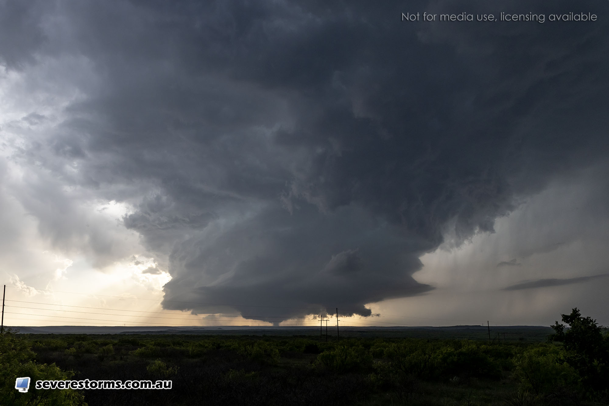
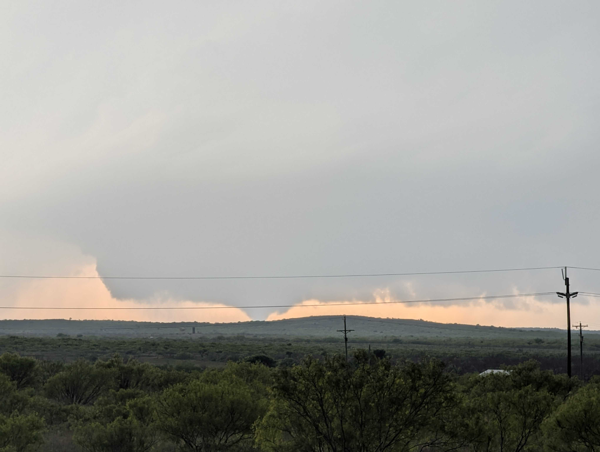
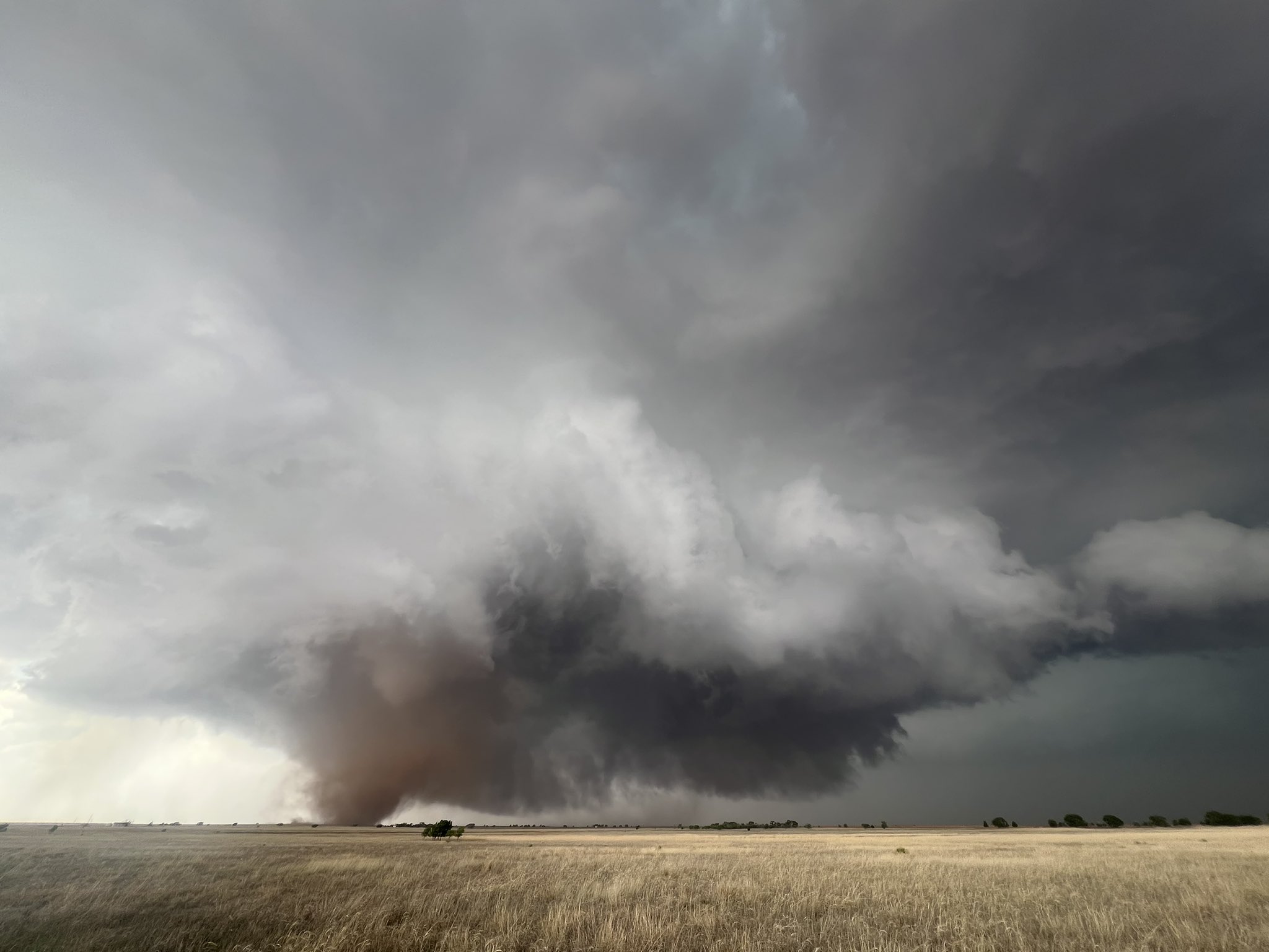
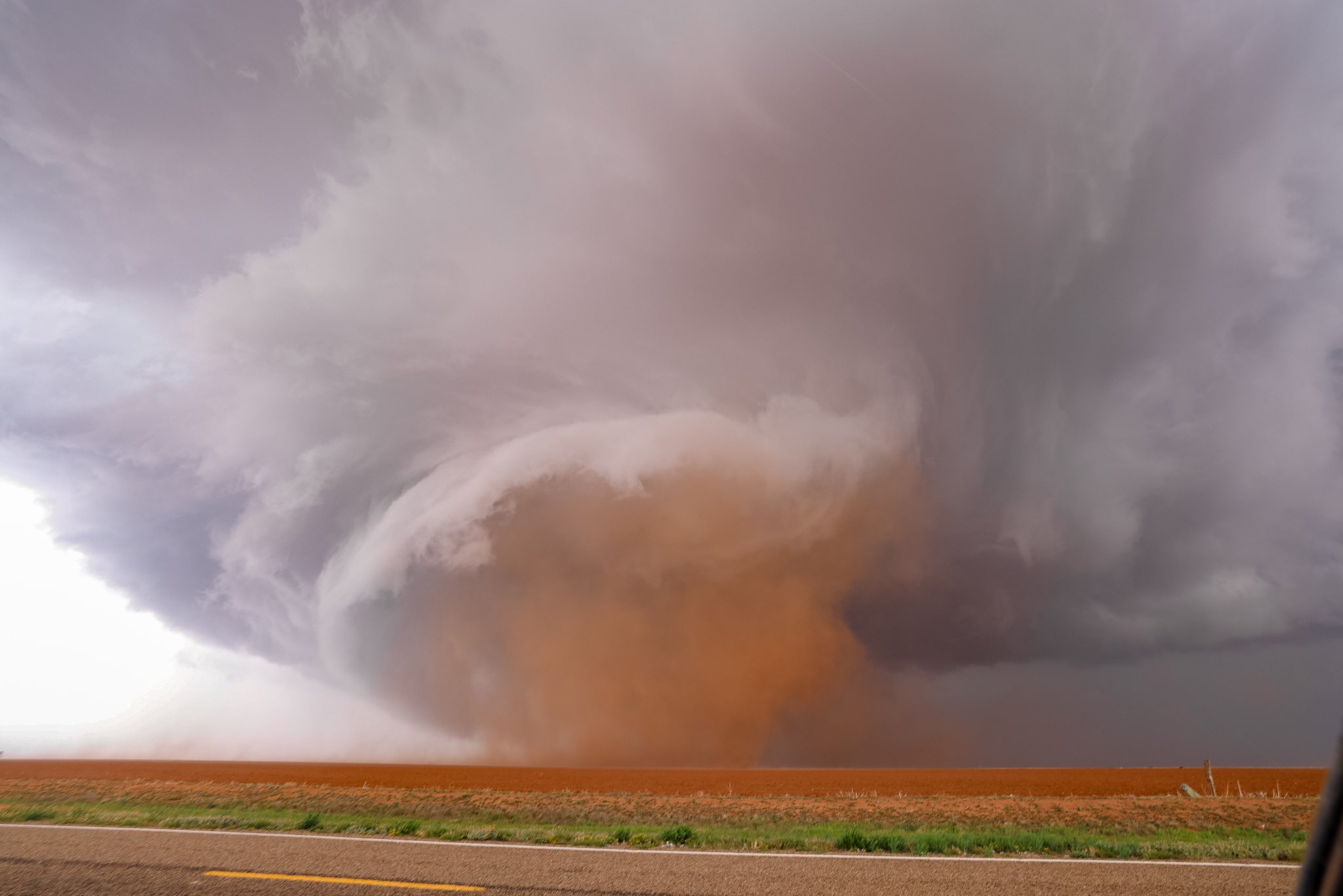
Supercell thunderstorm and tornado northwest of Matador on Thursday evening (24 April 2025). The picture is courtesy of Daniel Shaw. |
|
|
The daily rounds of severe weather, which started on April 22nd, took it up a notch on Thursday (24 April 2025). Richer low-level moisture, in tandem with a boundary that drifted into the area and provided enhanced easterly winds, added the ingredients that were lacking the previous couple of days and led to a couple of tornadic thunderstorms Thursday evening. |
|
 |
|
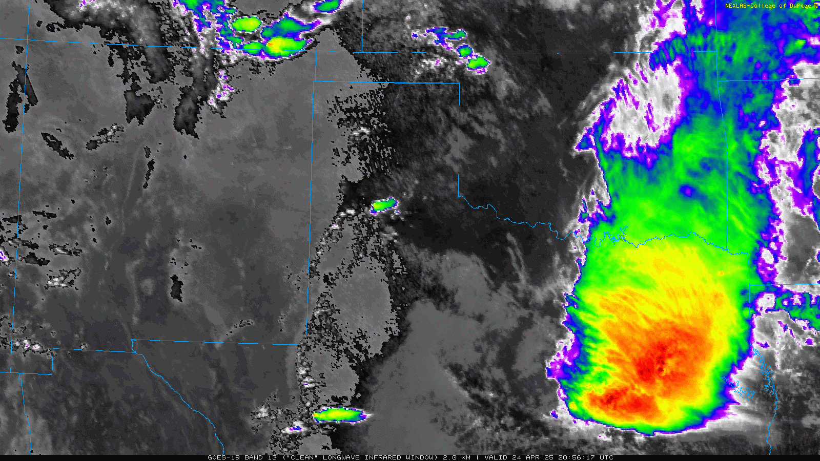
| Infrared satellite loop valid from 3:56 pm to 9:56 pm on Thursday (24 April 2025). | |
| Similar to the previous two days, the dryline provided the focus for thunderstorm development Thursday afternoon. This day, the dryline was located near the Interstate 27/Highway 87 Corridor when storms first bubbled up. Once they became rooted and tapped the strong instability in place, they quickly became severe and started to rotate. These supercell thunderstorms then slowed down and tracked south-southeastward, producing giant hail, torrential rain and tornadoes as they did so. | |
 |
|
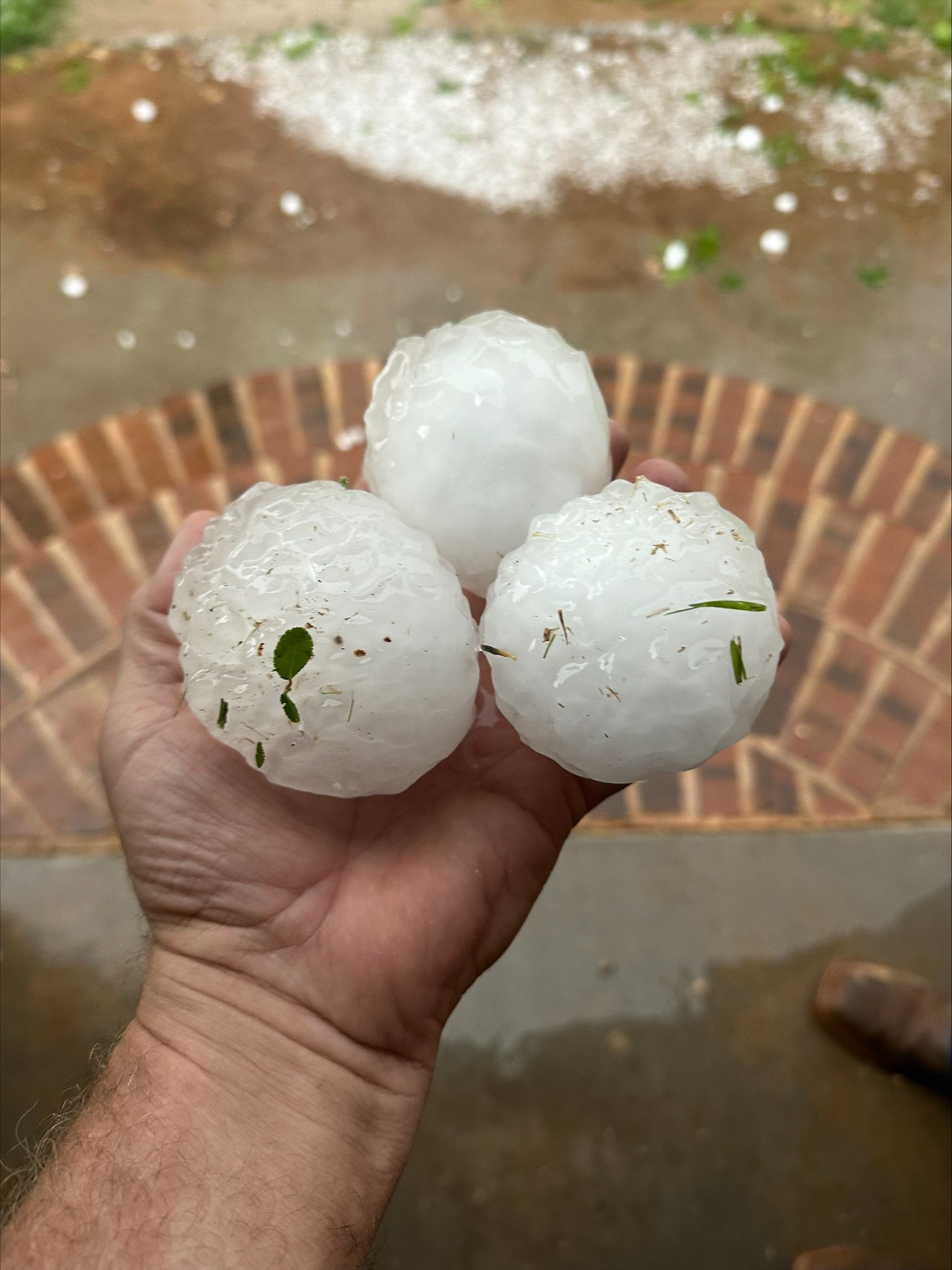
| Softball sized hail observed southeast of the community of South Plains on Thursday evening. The picture is courtesy of Adam Lucio via Facebook. | |
| The earliest intense storm of the evening produced its first tornado about 15 miles south of Silverton around 6:10 pm. This same storm dropped massive hail, as large as grapefruits, several miles northeast of the community of South Plains. In fact, one giant hailstone found 9 miles south-southwest of Flomot was measured to be 5.20 inches in diameter! | |
 |
|
| LBB WSR-88D radar animation valid from 2:56 pm to 9:57 pm on Thursday (24 April 2025). | |
| The thunderstorm went on to produce a couple more tornadoes, including one reported 9 miles southwest of Flomot at 7:15 pm, and a final brief tornado about 4 miles west of Roaring Springs at 8:02 pm. Not to be outdone, another supercell rapidly formed east of Lubbock and quickly turned severe, produced large hail, tornadoes and torrential rainfall. | |
 |
 |
| Tornado (left) observed northeast of Lockney and giant hail (right) that fell northwest of Matador on Thursday evening (24 April 2025). The images are courtesy of Kyle Watson and Mitchell Lazarow, respectively. | |
| Several tornadoes were observed with this "new" storm, including a short-lived tornado 10 miles south of Ralls at 7:35 pm, a more substantial and long-lived tornado about 10 miles west of White River Lake a little after 8 pm, another brief tornado 11 miles south-southwest of White River Lake a little before 9 pm, and a final tornado 13 miles east-northeast of Post shortly before 10 pm. |
|
 |
|
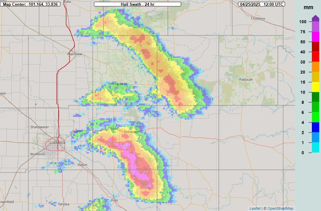
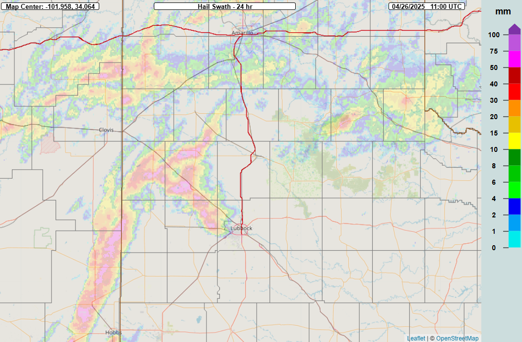
| Multi-Radar Multi-Sensor (MRMS) 24-hour estimated hail swath (hail size in mm) ending at 7 am on 25 April 2025. | |
|
Post-storm surveys were conducted on both tornadic storms the following day. Thankfully, both thunderstorms tracked over rural lands, with no tornado damage uncovered by either survey team (or reported back to the office by the public or county officials). That said, the remote location limited access, especially because the heavy rain made most unpaved roadways unpassable. |
|
 |
|
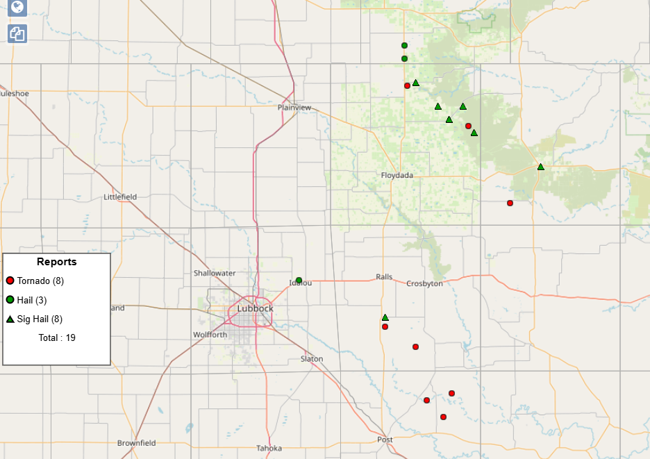
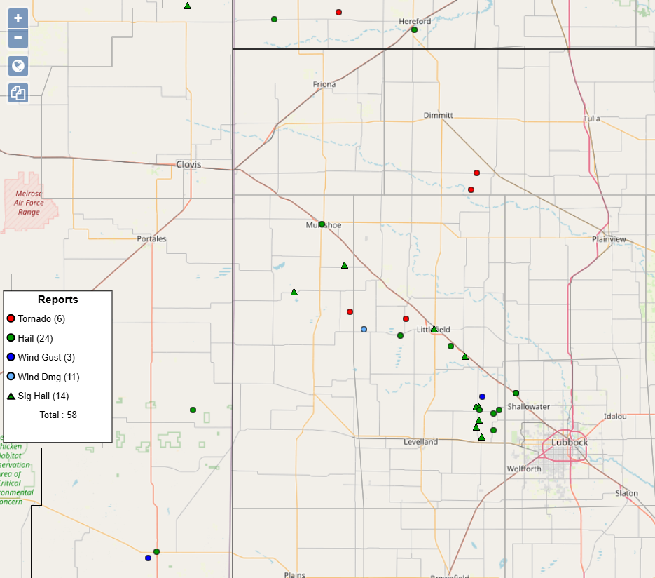
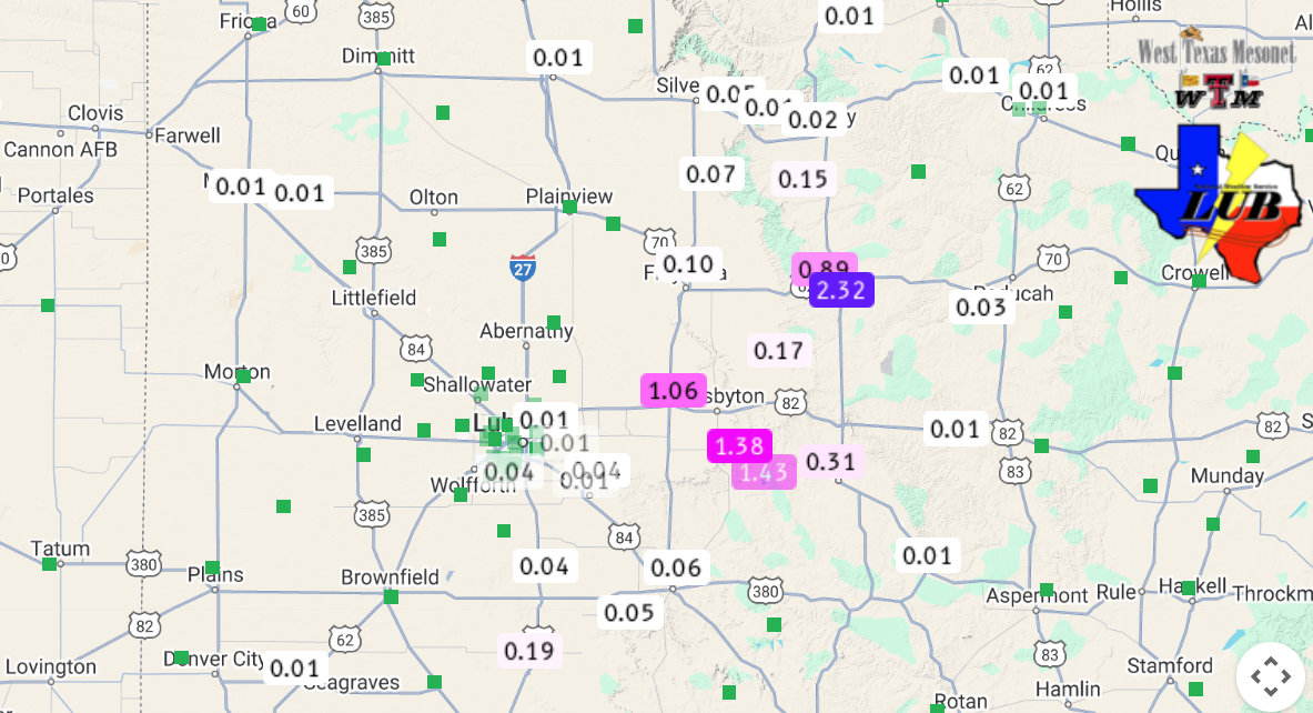
| Plot of the preliminary storm reports received by NWS Lubbock on Thursday (24 April 2025). | |
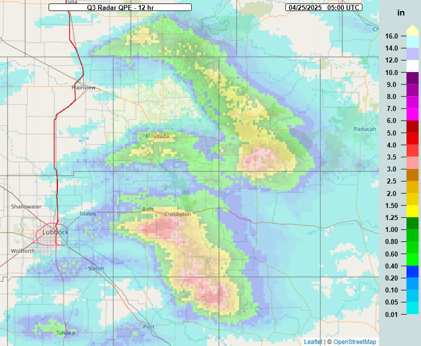
| In addition to the giant hail and tornadoes, the slow-moving storms dropped torrential rainfall along roughly the same path as the large hail. The West Texas Mesonet (WTM) and COOP observers within the reach of the thunderstorms measured rain totals of 1 to 3 inches, though in reality, there were likely pockets of rain near or in excess of 5 inches. | |
 |
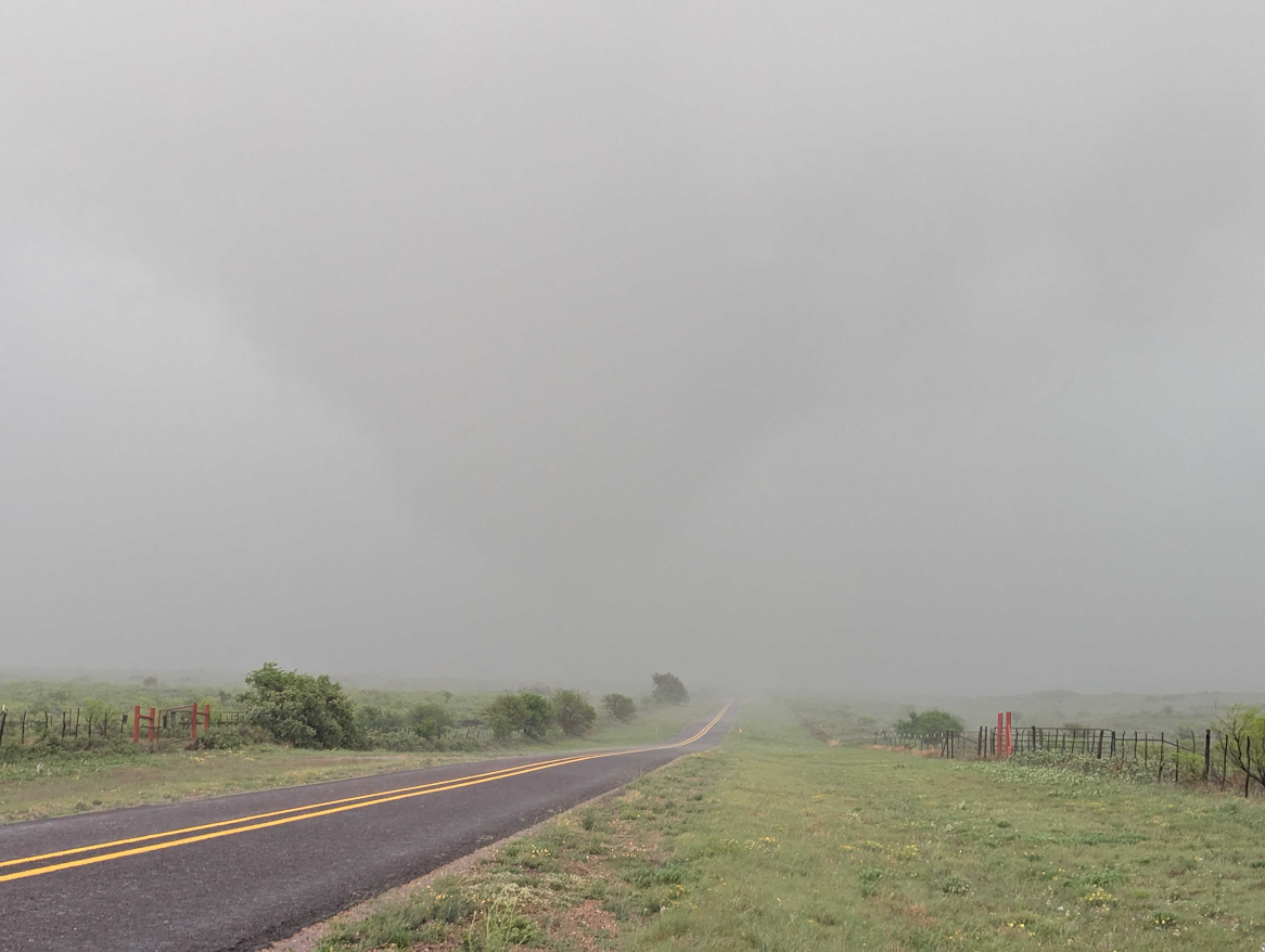 |
| Tornado northwest of Matador (left) and west of Roaring Springs (right) on Thursday evening (24 April 2025). Both pictures are courtesy of Joshua Ostaszewski. | |
|
In some cases, the heavy rain and hail wrapped around the rotating thunderstorms, making it difficult to spot tornadoes when they occurred (like the rain-wrapped tornado in the image above on the right). |
|
 |
|
| Tornado near Dougherty on Thursday evening (24 April 2025). The image is courtesy of Bruce Haynie. | |
| Another view of the tornado that occurred west of Roaring Springs Thursday evening, and became wrapped in rain and hail, can be found above. | |
 |
|
| 12-hour MRMS rainfall ending at midnight Thursday night (24 April 2025). The 12-hour rainfall, as measured by the West Texas Mesonet (WTM), ending at 10 pm on Thursday, can be VIEWED HERE. | |
|
The torrential rain did cause flash flooding, but some of the runoff also drained into White River Lake, raising the lake level about 1.5 feet, or 3% (from 16% to 19% of conservation level). |
|
 |
|
| White River Lake pool elevation (ft) ending on Friday morning (25 April 2025). | |
| The following day brought more of the same, with large hail, torrential rain and several tornadoes. The action this day started early Friday afternoon (25 April 2025) with the development of a thunderstorm over Baily County, where a couple of boundaries intersected. | |
 |
|
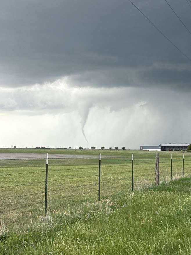
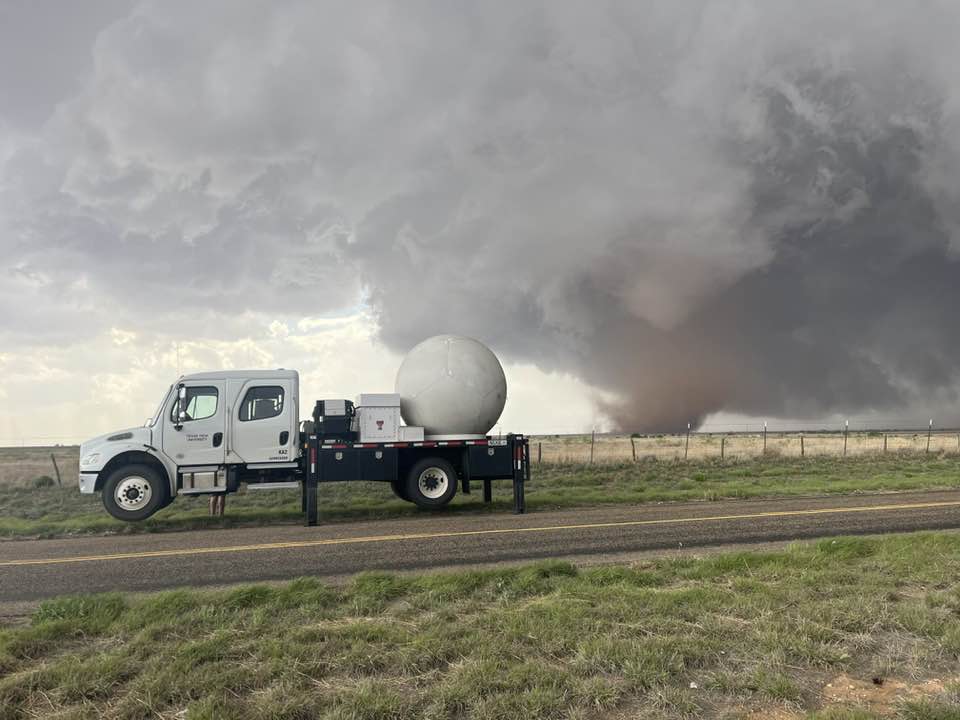
| Tornado, as viewed from south of Sudan, late Friday afternoon (25 April 2025). In the foreground is a mobile Doppler radar. The picture is courtesy of Chris Weiss. | |
| The Baily County storm quickly began to rotate and became severe. The cyclonically rotating supercell latched on to a northwest-to-southeast oriented outflow boundary and moved slowly southeastward along it roughly paralleling Highway 87. Air on the cooler (east) side of the boundary contained rich moisture and increasingly stout easterly winds which helped to enhance the low-level circulation within the storm. | |
 |
|
| "RCB-True Color" satellite loop valid from 12:36 pm to 5:56 pm on Friday (25 April 2025). An infrared satellite loop, valid from 1:06 pm on Friday to 4:26 am on Saturday (25-26 April) can be VIEWED HERE. | |
|
The thunderstorm went on to produce its first tornado of the day just after 4 pm approximately 7 miles east-northeast of the Muleshoe Wildlife Refuge. Many chasers were following this storm and the tornado was well documented and quite picturesque. |
|
 |
|
| Tornado near Enochs late Friday afternoon (25 April 2025). The picture is courtesy of Sam Dienst. | |
| The severe storm proceeded southeast at a snail's pace, producing one more tornado (about 6 miles west-northwest of Littlefield), numerous reports of large hail and torrential rainfall through the remainder of Friday afternoon and into Friday evening. Thankfully, both tornadoes were over rural land and inflicted no known damage. | |
 |
|
| LBB WSR-88D radar animation valid from 1:43 pm to 8:55 pm on Friday (25 April 2025). | |
| Hail as large as 4 inches in diameter was observed in Littlefield around 5 pm, as the storm continued to creep southeastward. To make matters worse, the storm slowed further, stalling for a period over eastern Hockley County Friday evening. The storm continued to drop large hail and torrential rainfall over rural areas for much of Friday evening before finally loosing strength and lifting northward late in the evening. | |
 |
|
| Plot of the preliminary storm reports received by NWS Lubbock on Friday (25 April 2025). | |
| The WTM site located 6 miles south of Anton recorded an impressive 5.83 inches of rainfall over 24 hours ending Saturday morning, with most of that falling Friday evening. There was even talk of upwards of 9 inches of rain west of Shallowater, relayed from a farmer, though that could not be confirmed. | |
 |
|
| Large hail that fell north of Whitharral late Friday afternoon (25 April 2025). The picture is courtesy of the Hockley County Sherriff's Office via Facebook. | |
| The semi-persistent supercell thunderstorm did eventually dissipate, though not until around midnight over western Hale County. However, additional activity moved in from the west, while more widespread showers and thunderstorms filled in over the southern Texas Panhandle easterly Saturday morning (26 April). | |
 |
|
| Tornado near Sudan late Friday afternoon (25 April 2025). The picture is courtesy of Matthew Gaylor. | |
| One of these late-night storms became particularly intense as it moved from the northwestern South Plains into the south-central Texas Panhandle in the predawn hours of Saturday. This storm generated two reported tornadoes, one about 7 miles southwest of Hart at 2:35 am and another 4 miles west of Hart at 3 am. | |
 |
|
| LBB WSR-88D radar animation valid from 10:40 pm on Friday to 3:58 am on Saturday (25-26 April 2025). Another wider radar view, valid from 07:03 pm on Friday to 4:41 am on Saturday, can be VIEWED HERE. | |
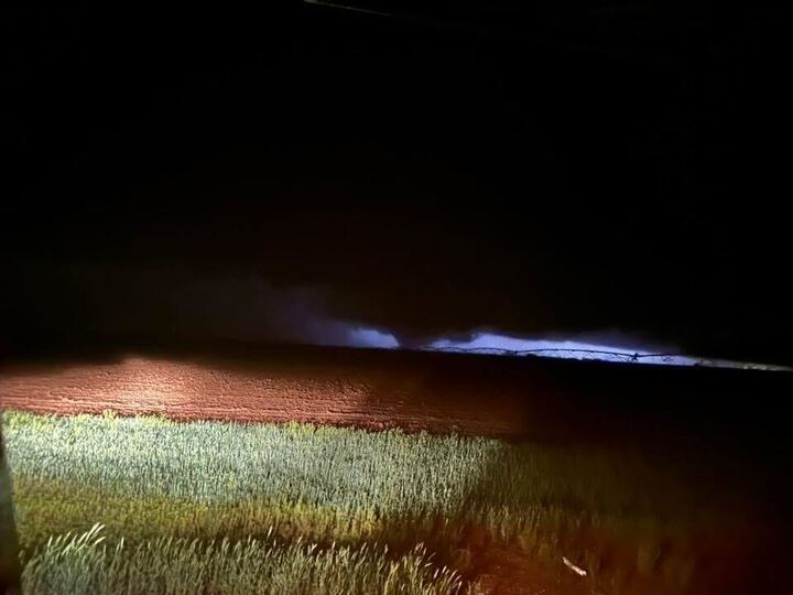
| Thankfully, the late-night tornadoes occurred in open land and caused no known damage. However, they did make for an eerie sight for those out observing and chasing in the middle of the night, as can be seen in the below image. | |
 |
|
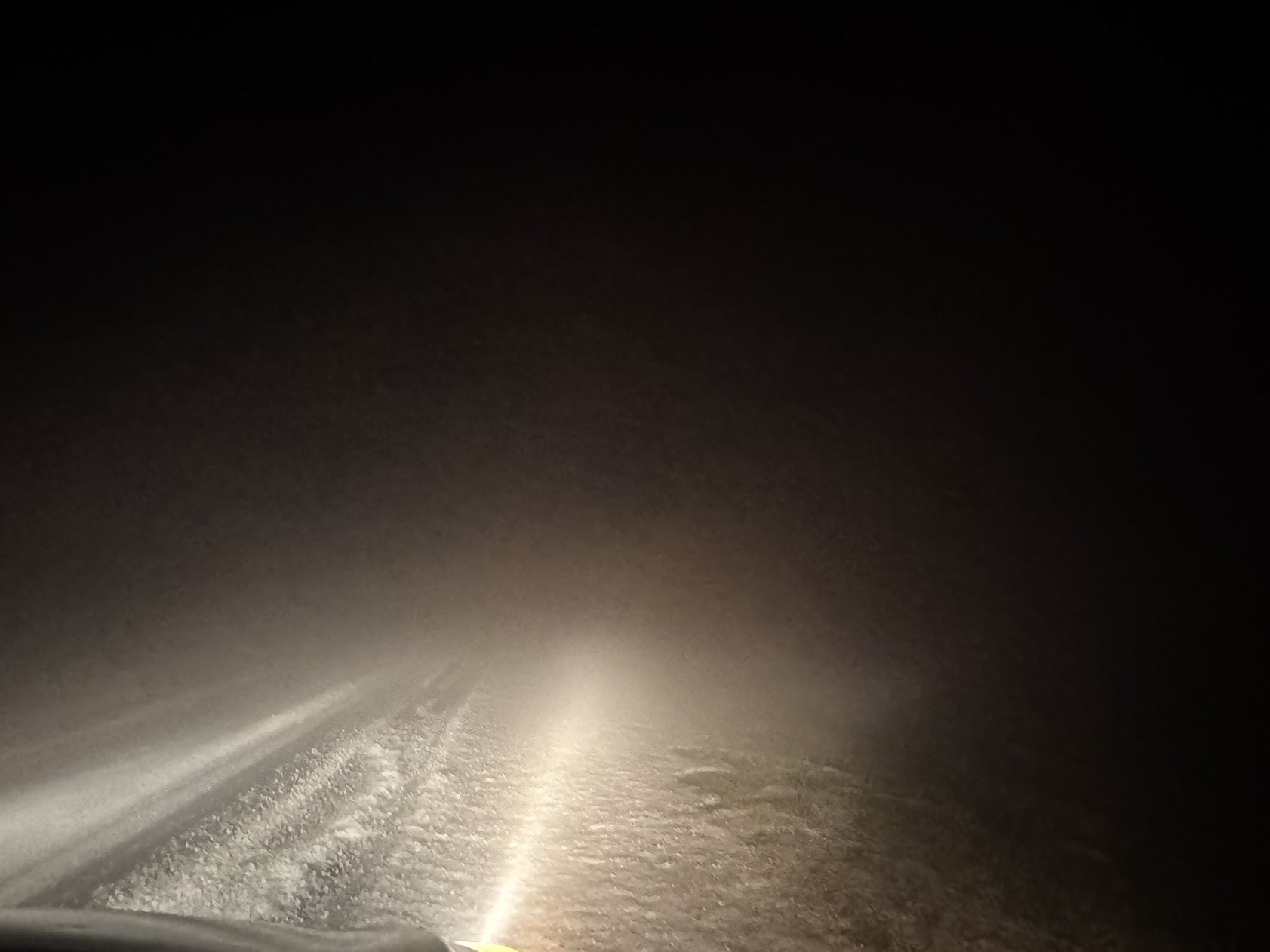
| Overnight tornado observed near Hart at 2:35 am early Saturday morning (26 April 2025). The picture is courtesy of the public via Jacob Riley. | |
| The overnight tornadic storm also produced copious amounts of hail. Although most of this hail was small, it did pile up on roadways and made travel difficult. This was compounded by thick hail fog that formed after the thunderstorm moved off to the northeast. | |
 |
|
| Accumulating hail and thick hail fog west of Springlake at 2:52 am early Saturday morning (26 April 2025). The picture is courtesy of Sam Gardner. A 24-hour hail swath, as estimated by the Multi-Radar Multi-Sensor (MRMS), ending at 6 am on Saturday can be FOUND HERE. | |
| Even after the most intense of the thunderstorms concluded, the night was far from done. Instead, widespread heavy rainfall tracked repeatedly over the southern Texas Panhandle through Saturday morning. The heavy rain resulted in significant flooding, concentrated over portions of the southeast Texas Panhandle. | |
 |
|
| LBB WSR-88D radar animation valid from 1:02 am to 10:18 am on Saturday (26 April 2025). An additional radar animation, valid from 10:34 am to 2:17 pm on Saturday, can be VIEWED HERE. | |
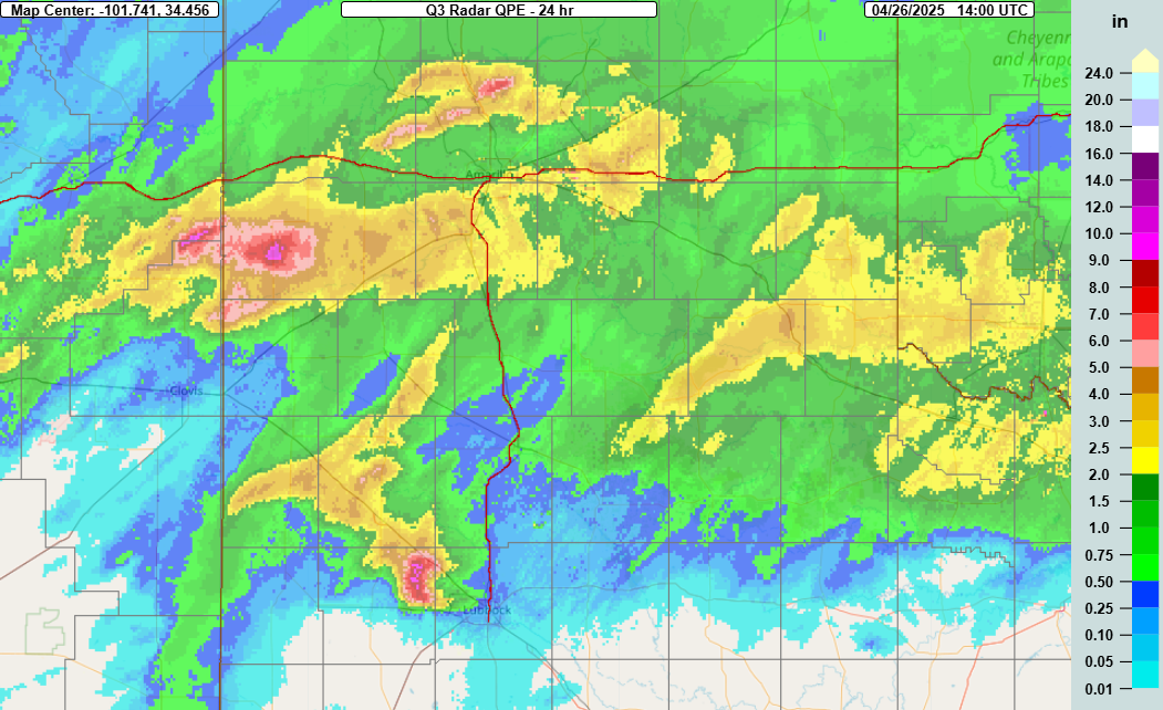
| Outside of the incredible rain over northeast Hockley County, associated with the stalled supercell, a large swath of 2 to 3+ inches of rain fell over northern Childress and much of Hall Counties, as can be seen below. | |
 |
|
| 24-hour MRMS rainfall ending at 9 am on Saturday (26 April 2025). | |
| The heavy rain caused the rivers and streams to flow with vigor, damaged some roads and drainages and flooded numerous roadways, causing significant road closures. Highway 287, between Estelline and Memphis, was closed much of the day Saturday as TXDOT cleared the road of mud and debris from flooding. Highway 256, from Memphis to Lakeview, was also closed for a period due to the flooding. The muddy roadways also contributed to at least one accident along Highway 86 northeast of Turkey. | |
 |
|
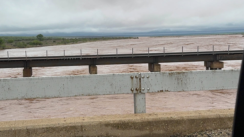
| Prairie Dog Town Fork of the Red River at Childress 10N stage (ft) in late April 2025. | |
| The excessive runoff caused the normally tame, and sometimes dry, Prairie Dog Town Fork of the Red River to flow like a major river, as is illustrated in the picture below. The river even briefly breached minor flood stage Saturday morning before receding. | |
 |
|
| Prairie Dog Town Fork of the Red River north of Estelline Saturday morning (26 April 2025). The picture is courtesy of John Lipe. | |
| The following several images reflect the flooding that impacted the southeast Texas Panhandle Friday night into Saturday. All of the images were captured during a post-storm damage survey conducted by NWS Lubbock. | |
 |
 |
 |
 |
 |
 |
 |
 |
 |
 |
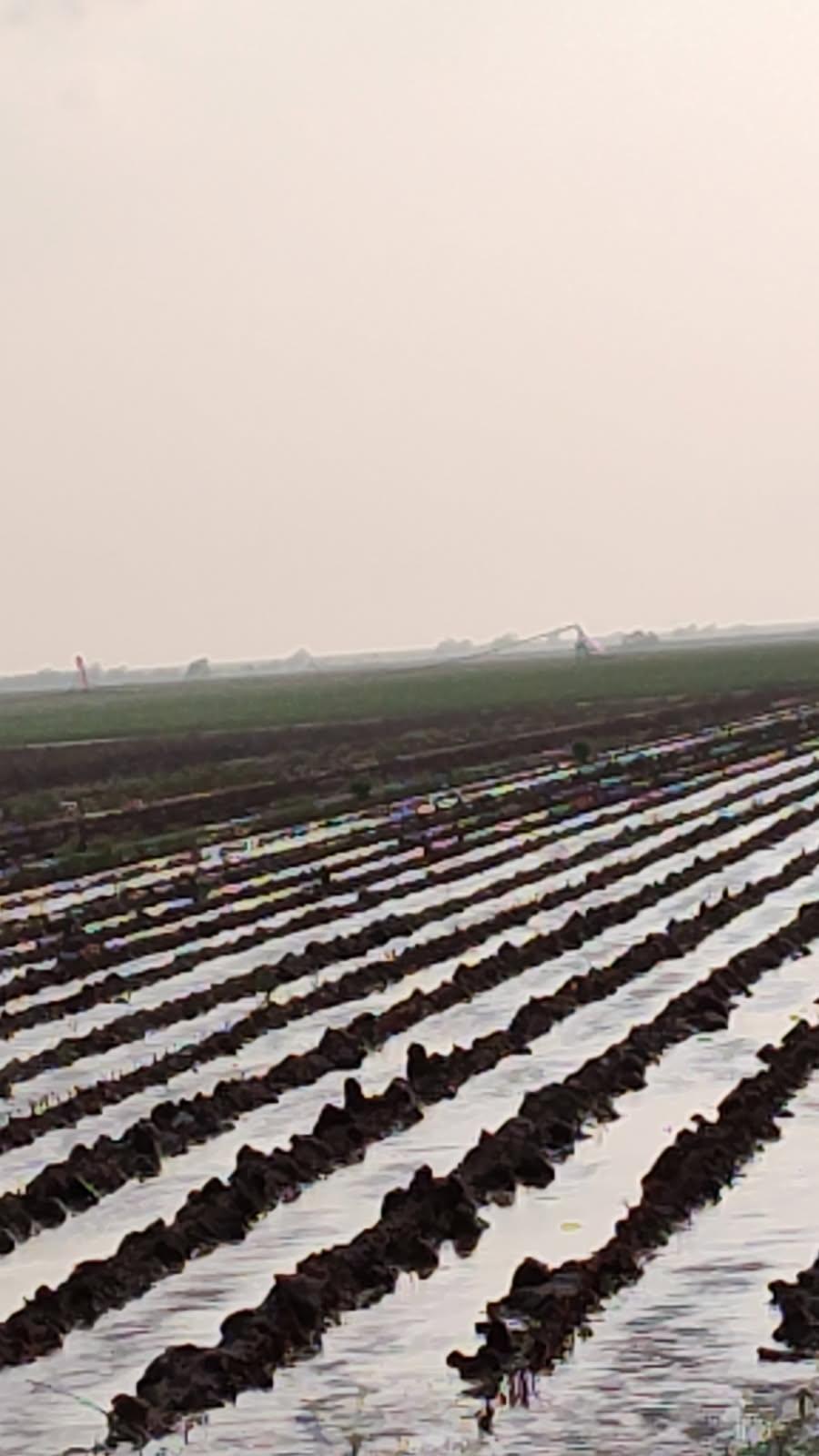
| Pictures of active flooding, flooding damage and swelling rivers/streams on Saturday (26 April 2025) over parts of Childress and Hall Counties. The pictures are courtesy of John Lipe. | |
| Below are pictures of flooding and damage experienced in northern Hockley County, thanks primarily to the nearly stationary severe thunderstorm that camped over the area much of Friday evening. | |
 |
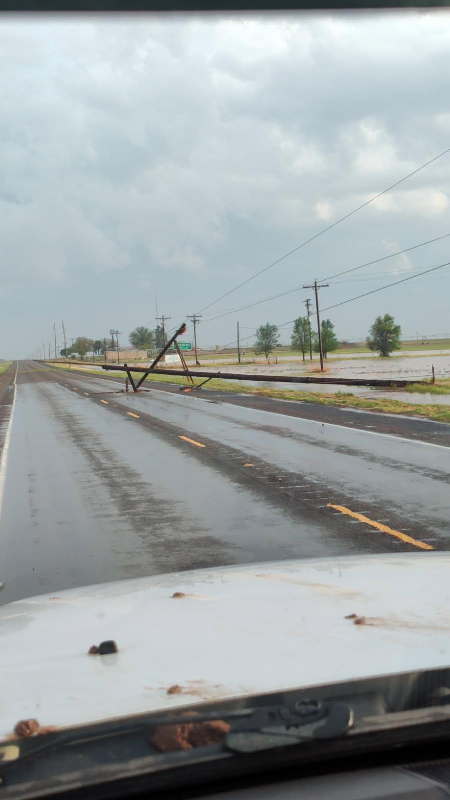 |
| Flooding and damage on FM 597 east of Highway 385 (north of Whitharral) near the Lamb County line on Friday evening (26 April 2025). The pictures are courtesy of the Hockley County Sherriff's Office via Facebook. | |
| Additional pictures of flooding near Anton can be found below. | |
 |
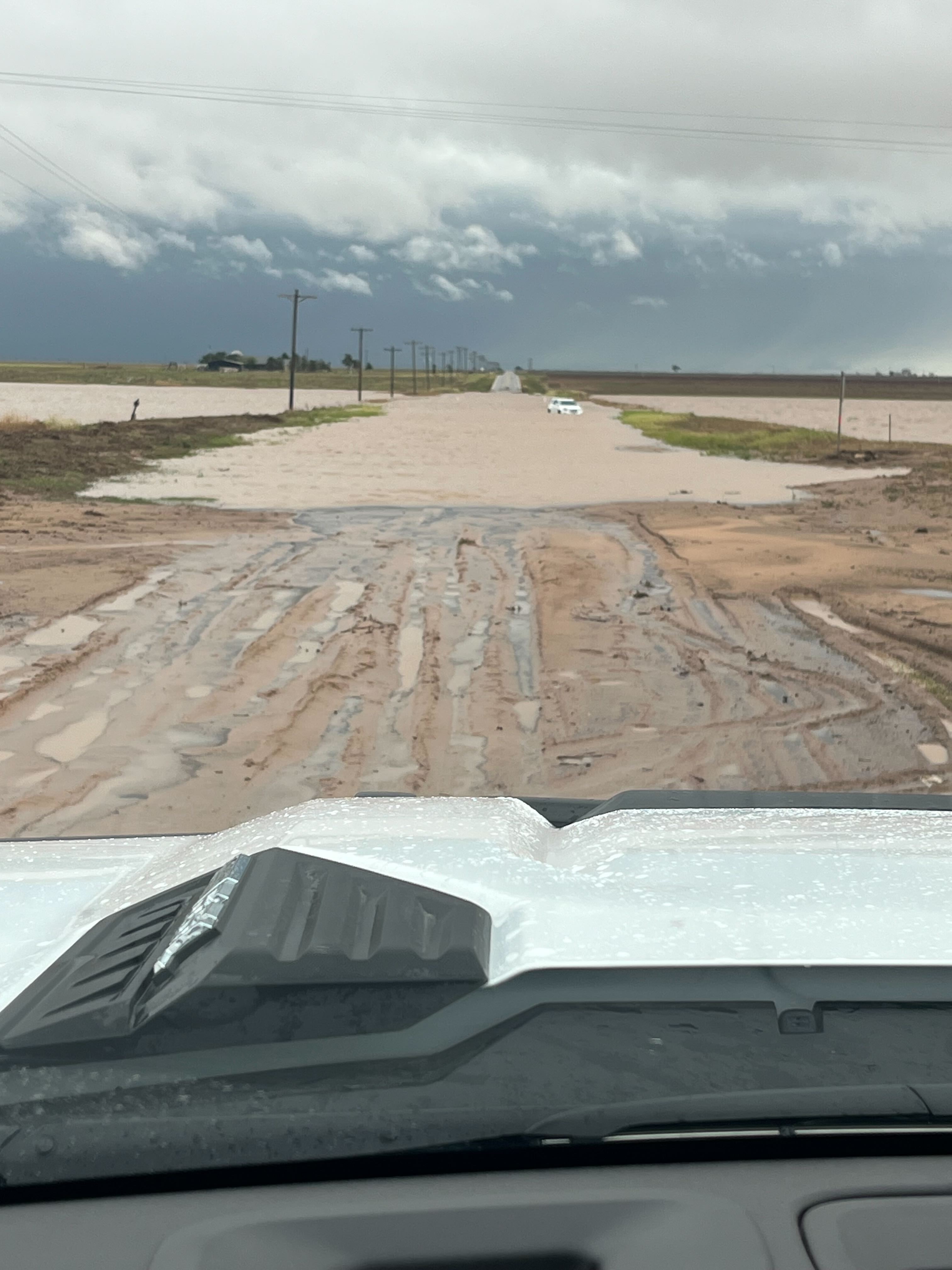 |
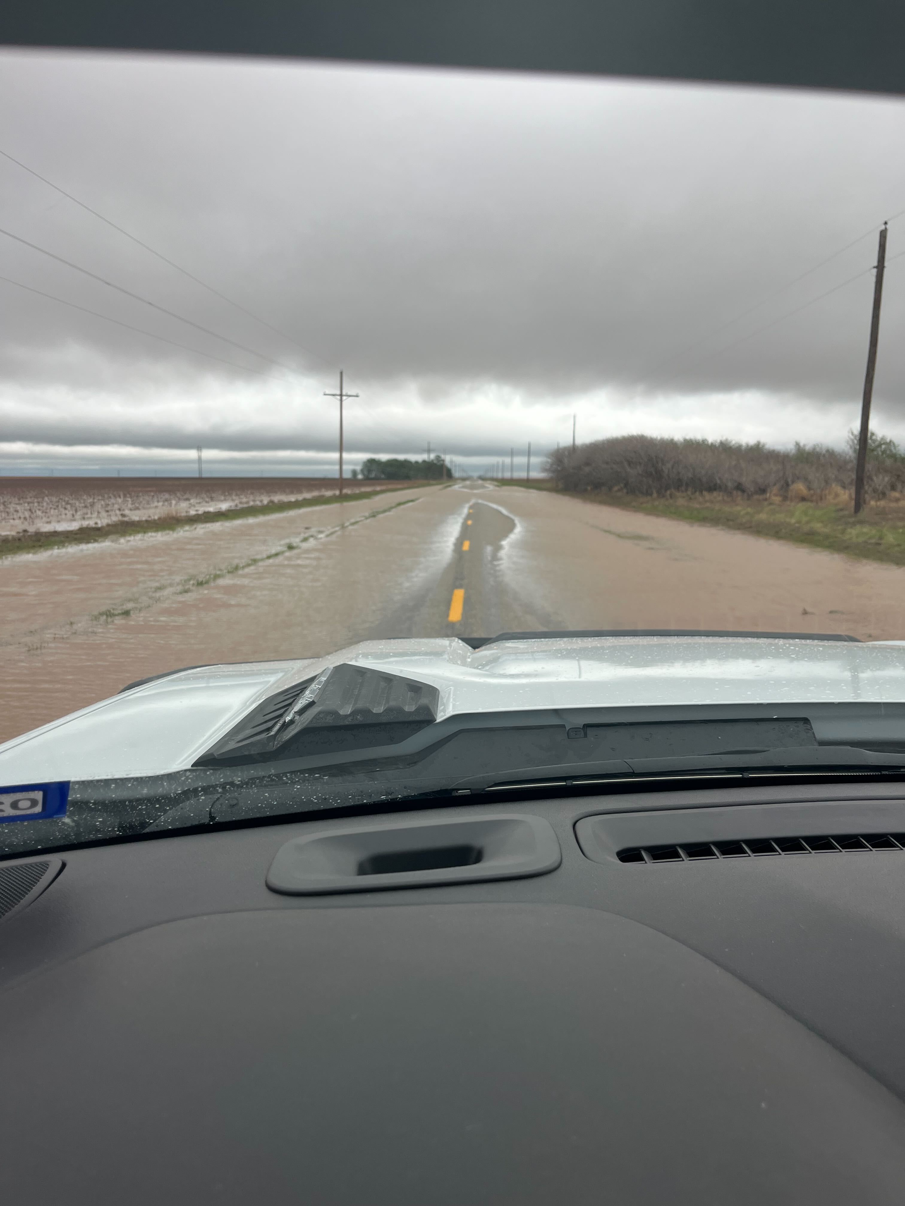
| Pictures of flooding near Anton Saturday morning (26 April 2025). The images are courtesy of Cole Kirkland. | |
| A list of the preliminary storm reports collected on April 24th through 26th can be found below. | |
Preliminary Local Storm Report...Summary...Corrected
National Weather Service Lubbock TX
104 AM CDT Fri Apr 25 2025

..TIME...   ...EVENT...      ...CITY LOCATION...     ...LAT.LON...
..DATE...   ....MAG....      ..COUNTY LOCATION..ST.. ...SOURCE....
            ..REMARKS..

0550 PM     Hail             7 S Silverton           34.37N 101.31W
04/24/2025  E1.25 Inch       Briscoe            TX   Public

            mPing.

0557 PM     Hail             7 N South Plains        34.33N 101.31W
04/24/2025  E1.50 Inch       Briscoe            TX   Public

            Report from mPING: Ping Pong Ball (1.50
            in.).

0610 PM     Tornado          15 S Silverton          34.25N 101.30W
04/24/2025                   Floyd              TX   Storm Chaser

            Multiple reports confirmed via video feed.

0613 PM     Hail             Idalou                  33.67N 101.69W
04/24/2025  E1.00 Inch       Lubbock            TX   Public

            Report from mPING: Quarter (1.00 in.).

0633 PM     Hail             3 NE South Plains       34.26N 101.27W
04/24/2025  M2.50 Inch       Floyd              TX   Trained Spotter

            NSSL Report.

0700 PM     Hail             10 ESE South Plains     34.15N 101.15W
04/24/2025  M4.50 Inch       Floyd              TX   Public

            Via X ...tape measured.

0702 PM     Hail             7 ESE South Plains      34.19N 101.19W
04/24/2025  E4.00 Inch       Floyd              TX   Public


0702 PM     Hail             10 SE South Plains      34.15N 101.15W
04/24/2025  E4.00 Inch       Floyd              TX   Public

            Report from mPING: Grapefruit (4.00 in.).

0715 PM     Tornado          9 SW Flomot             34.13N 101.08W
04/24/2025                   Floyd              TX   Public

            Multiple public and spotter reports.

0715 PM     Hail             7 W Flomot              34.19N 101.10W
04/24/2025  E4.00 Inch       Floyd              TX   Public

            Report from mPING: Grapefruit (4.00 in.).

0727 PM     Hail             9 SSW Flomot            34.11N 101.06W
04/24/2025  M5.20 Inch       Floyd              TX   Public

            Via X...measured with calipers. Exact
            location estimated with radar.

0735 PM     Tornado          10 S Ralls              33.53N 101.38W
04/24/2025                   Crosby             TX   Law Enforcement

            Short lived tornado. Crosby SO.

0744 PM     Flood            1 NE Crosbyton          33.66N 101.23W
04/24/2025                   Crosby             TX   Public

            Report from mPING: River/Creek overflowing;
            Cropland/Yard/Basement Flooding.

0801 PM     Hail             Matador                 34.01N 100.82W
04/24/2025  M5.00 Inch       Motley             TX   Public


0802 PM     Tornado          4 W Roaring Springs     33.90N 100.93W
04/24/2025                   Motley             TX   Law Enforcement

            Brief tornado observed.

0802 PM     Hail             8 S Ralls               33.56N 101.38W
04/24/2025  M2.50 Inch       Crosby             TX   Public

            Multiple reports.

0810 PM     Flood            1 S Matador             34.01N 100.82W
04/24/2025                   Motley             TX   Public

            Report from mPING: River/Creek overflowing;
            Cropland/Yard/Basement Flooding.

0815 PM     Tornado          10 W White River Lake   33.47N 101.27W
04/24/2025                   Crosby             TX   Storm Chaser

            Potentially as wide as 1/4 mile at greatest
            intensity.

0850 PM     Tornado          11 SSW White River Lake 33.33N 101.14W
04/24/2025                   Garza              TX   Public

            Brief touchdown occurred.

0922 PM     Tornado          12 NE Post              33.31N 101.23W
04/24/2025                   Garza              TX   Storm Chaser


0924 PM     Flash Flood      1 N Crosbyton           33.66N 101.24W
04/24/2025                   Crosby             TX   Public

            Report from mPING: Street/road flooding;
            Street/road closed; Vehicles stranded.

0951 PM     Tornado          13 ENE Post             33.26N 101.17W
04/24/2025                   Garza              TX   CO-OP Observer


1048 PM     Flash Flood      Floydada                33.99N 101.34W
04/24/2025                   Floyd              TX   Public

            Report from mPING: Street/road flooding;
            Street/road closed; Vehicles stranded.
Public Information Statement...UPDATED
National Weather Service Lubbock TX
727 PM CDT Thu May 1 2025

...NWS Damage Survey for 04/24/25 Tornado and Flash Flooding Event...

.Overview...
Supercell thunderstorms produced ten tornadoes, very large hail, and flash flooding
across the eastern South Plains and Rolling Plains Thursday afternoon and evening of 24
April. Ground surveys were conducted the next morning. However, due to the lack of roads
in the suspected damage area along with the extensive flooding, the surveys were unable to
locate any wind or tornado damage. Some additional information was gathered from storm
chaser reports and video. Satellite data has not been examined for tornado tracks as the
cloud cover in the available data has been too extensive for analysis. Some mobile Doppler
radar data is also available for possible future analysis. EF tracks and/or ratings for
some tornadoes may be able to be updated based on these potential datasets.

.Briscoe-Floyd Counties Anti-Cyclonic Tornado...

Rating:                 EFU
Estimated Peak Wind:    Unknown
Path Length /statute/:  3.24 miles
Path Width /maximum/:   Unknown
Fatalities:             0
Injuries:               0

Start Date:             04/24/2025
Start Time:             06:10 PM CDT
Start Location:         6 NNW South Plains / Floyd County / TX
Start Lat/Lon:          34.305 / -101.3649

End Date:               04/24/2025
End Time:               06:16 PM CDT
End Location:           7 N South Plains / Briscoe County / TX
End Lat/Lon:            34.3384 / -101.326

Survey Summary:
Multiple chaser reports/video. No damage reported. The tornado was anticyclonic. The tornado is currently
rated EF-Unknown, but based on Vrot measured of 36 kts from KAMA WSR-88D and its appearance on video, a peak
wind gust speed of 110 mph (EF-1) is plausible.

.Southeast Crosby County Tornado 1...

Rating:                 EFU
Estimated Peak Wind:    Unknown
Path Length /statute/:  3.37 miles
Path Width /maximum/:   Unknown
Fatalities:             0
Injuries:               0

Start Date:             04/24/2025
Start Time:             07:01 PM CDT
Start Location:         6 ESE Caprock / Crosby County / TX
Start Lat/Lon:          33.4629 / -101.3101

End Date:               04/24/2025
End Time:               07:15 PM CDT
End Location:           7 W Kalgary / Crosby County / TX
End Lat/Lon:            33.42 / -101.2823

Survey Summary:
Adjusted chaser report slightly southwest based on KLBB WSR-88D Vrot. Max Vrot approx 45
kt. Chaser reported possible 1/4 mi wide at peak intensity. The tornado is currently rated
EF-Unknown, but based on Vrot and its reported appearance, a peak wind gust speed of 110
mph (EF-1) is plausible.

.Floyd-Motley Counties long-track Tornado...

Rating:                 EFU
Estimated Peak Wind:    Unknown
Path Length /statute/:  9.71 miles
Path Width /maximum/:   Unknown
Fatalities:             0
Injuries:               0

Start Date:             04/24/2025
Start Time:             07:10 PM CDT
Start Location:         5 ESE Cedar Hill / Floyd County / TX
Start Lat/Lon:          34.1329 / -101.1188

End Date:               04/24/2025
End Time:               07:38 PM CDT
End Location:           8 NE Dougherty / Motley County / TX
End Lat/Lon:            34.0339 / -101.0007

Survey Summary:
Multiple public and storm chaser reports of a tornado. No damage reported or found, but
based on video, the tornado likely moved through or very close to a wind farm.
Additionally, trees/shrubs were lofted and power flashes were observed in video. Based on
the video and KLBB WSR-88D with peak Vrot of 72 kts at 0020 UTC, peak wind gusts up to
120-135 mph (EF2 to EF3) are plausible with this tornado. NSSL RaXPol and Texas Tech
University Ka mobile Doppler radar velocity data is also available for some portions of
the tornado track. Also notable is hail up to 5 inches in diameter was documented by storm
chasers with this storm in-between the towns of South Plains and Matador.

.Southeast Crosby County Tornado 2...

Rating:                 EF0
Estimated Peak Wind:    75 mph
Path Length /statute/:  1.48 miles
Path Width /maximum/:   Unknown
Fatalities:             0
Injuries:               0

Start Date:             04/24/2025
Start Time:             07:34 PM CDT
Start Location:         4 NNE Caprock / Crosby County / TX
Start Lat/Lon:          33.5334 / -101.3955

End Date:               04/24/2025
End Time:               07:37 PM CDT
End Location:           4 NE Caprock / Crosby County / TX
End Lat/Lon:            33.5236 / -101.3727

Survey Summary:
Law Enforcement observed a brief tornado, no damage. KLBB WSR-88D Vrot under 25 kts.

.Garza County Tornado 1...

Rating:                 EF0
Estimated Peak Wind:    75 mph
Path Length /statute/:  1.15 miles
Path Width /maximum/:   Unknown
Fatalities:             0
Injuries:               0

Start Date:             04/24/2025
Start Time:             07:48 PM CDT
Start Location:         6 SW Kalgary / Garza County / TX
Start Lat/Lon:          33.3403 / -101.2145

End Date:               04/24/2025
End Time:               07:51 PM CDT
End Location:           6 SSW Kalgary / Garza County / TX
End Lat/Lon:            33.3256 / -101.2049

Survey Summary:
Adjusted public report west based on KLBB rotation. Rated EF0 based on KLBB WSR-88D Vrot
< 20 kt.

.Southwest Motley County Tornado...

Rating:                 EFU
Estimated Peak Wind:    Unknown
Path Length /statute/:  1.85 miles
Path Width /maximum/:   Unknown
Fatalities:             0
Injuries:               0

Start Date:             04/24/2025
Start Time:             08:01 PM CDT
Start Location:         4 WNW Roaring Springs / Motley County / TX
Start Lat/Lon:          33.927 / -100.9184

End Date:               04/24/2025
End Time:               08:06 PM CDT
End Location:           3 W Roaring Springs / Motley County / TX
End Lat/Lon:            33.9002 / -100.9189

Survey Summary:
A brief tornado observed by law enforcement west of Roaring Springs. The location corresponded to
a peak Vrot of 40 kts from KLBB at 8:03 pm CDT. Track and duration estimated by radar.

.Garza County Tornado 2...

Rating:                 EF0
Estimated Peak Wind:    Unknown
Path Length /statute/:  2.04 miles
Path Width /maximum/:   Unknown
Fatalities:             0
Injuries:               0

Start Date:             04/24/2025
Start Time:             09:08 PM CDT
Start Location:         10 S Kalgary / Garza County / TX
Start Lat/Lon:          33.2598 / -101.1546

End Date:               04/24/2025
End Time:               09:14 PM CDT
End Location:           8 S Kalgary / Garza County / TX
End Lat/Lon:            33.2811 / -101.1307

Survey Summary:
First of likely three tornadoes associated with large, slow-moving supercell.

.Garza County Tornado 3...

Rating:                 EFU
Estimated Peak Wind:    Unknown
Path Length /statute/:  1.83 miles
Path Width /maximum/:   Unknown
Fatalities:             0
Injuries:               0

Start Date:             04/24/2025
Start Time:             09:24 PM CDT
Start Location:         7 SSW Kalgary / Garza County / TX
Start Lat/Lon:          33.3156 / -101.1905

End Date:               04/24/2025
End Time:               09:30 PM CDT
End Location:           5 SSW Kalgary / Garza County / TX
End Lat/Lon:            33.3422 / -101.1898

Survey Summary:
Over open country, no damage reported. Peak Vrot from KLBB WSR-88D 41 kts Gate-to-gate.
Garza County tornadoes 3 and 4 were both in contact with the ground for a period of
time per storm chasers and radar.


.Garza County Tornado 4...

Rating:                 EFU
Estimated Peak Wind:    Unknown
Path Length /statute/:  1.81 miles
Path Width /maximum/:   0 yards
Fatalities:             0
Injuries:               0

Start Date:             04/24/2025
Start Time:             09:24 PM CDT
Start Location:         11 S Kalgary / Garza County / TX
Start Lat/Lon:          33.2423 / -101.1444

End Date:               04/24/2025
End Time:               09:32 PM CDT
End Location:           10 S Kalgary / Garza County / TX
End Lat/Lon:            33.2518 / -101.1158

Survey Summary:
Over open country, no damage. Peak Vrot from KLBB WSR-88D 35 kts Gate-to-gate.
Garza County tornadoes 3 and 4 were both in contact with the ground for a period of
time per storm chasers and radar.

.Garza County Tornado 5...

Rating:                 EFU
Estimated Peak Wind:    Unknown
Path Length /statute/:  1.79 miles
Path Width /maximum/:   Unknown
Fatalities:             0
Injuries:               0

Start Date:             04/24/2025
Start Time:             09:50 PM CDT
Start Location:         10 S Kalgary / Garza County / TX
Start Lat/Lon:          33.2579 / -101.1621

End Date:               04/24/2025
End Time:               09:55 PM CDT
End Location:           10 S Kalgary / Garza County / TX
End Lat/Lon:            33.2524 / -101.1325

Survey Summary:
Observed by Co-op Observer. Vrot noisy, no estimate on tornado strength.

.Flash Flooding in southern Crosby and Northern Garza Counties....

Start Lat/Lon:          33.5584 / -101.3004
Survey Summary:
The survey team found evidence of very large hail (divots in wet soil approx. 4 inch in diameter)
along FM40, 5 miles east of 207. FM 40 also was covered in mud in several areas east of FM 207,
indicative of water over the roadway earlier. Water was flowing across FM 2008 3 miles south of FM 651
early Friday afternoon. Most of the county roads were muddy and impassible.

&&

EF Scale: The Enhanced Fujita Scale classifies tornadoes into the
following categories:

EF0.....65 to 85 mph
EF1.....86 to 110 mph
EF2.....111 to 135 mph
EF3.....136 to 165 mph
EF4.....166 to 200 mph
EF5.....>200 mph

NOTE:
The information in this statement is preliminary and subject to
change pending final review of the events and publication in NWS
Storm Data.

