
Tropical Storm Bertha could bring tropical storm conditions to portions of the Florida Panhandle and Alabama coast through Wednesday, where a Tropical Storm Watch and Storm Surge Watch is in effect. Numerous severe thunderstorms with heavy rainfall are expected from the Ohio Valley into the Mid-Atlantic and Northeast Tuesday. Read More >
|
Widespread rainfall falls on West Texas |
|
 |
|
|
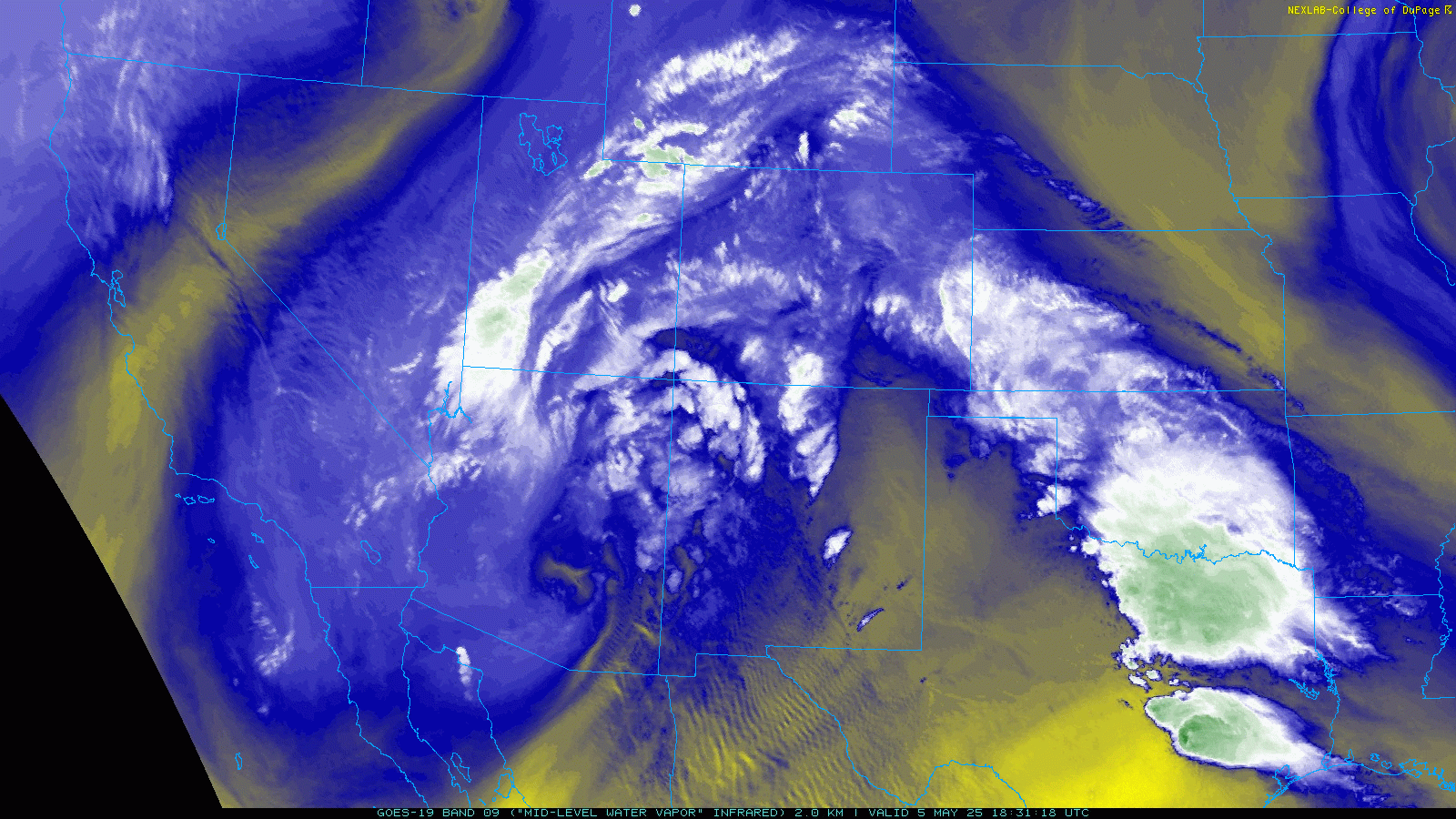
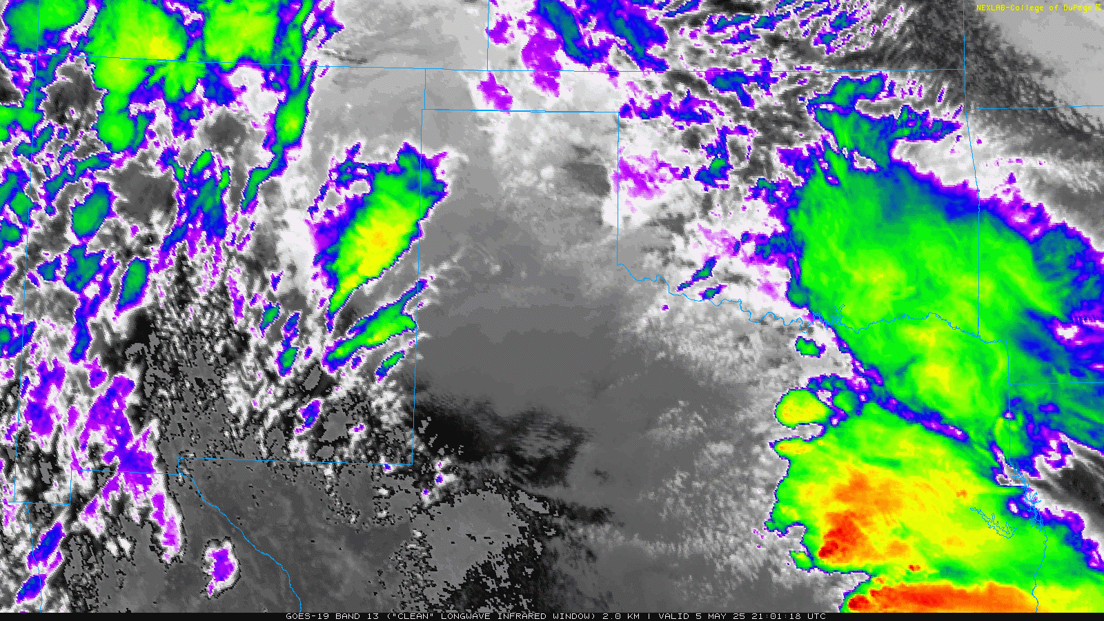
Water vapor satellite loop valid from 1:30 pm on Monday to 5:01 pm on Tuesday (5-6 May 2025). |
|
|
After a relatively "quiet" start to May, and following an active end to April, the weather quickly turned back to the unsettled side on Monday, May 5th. Even before Cinco de Mayo, Sunday (May 4th) turned active in New Mexico, with one intense storm surviving the trek across the state line, bringing hail and heavy rain to southern parts of Yoakum County Sunday evening before weakening over Terry County, southwest of Brownfield. Areas farther east and northeast, into the South Plains, did experience a little light rain Sunday night into early Monday, though the bulk of the activity didn't really kick off until Monday morning. |
|
 |
|
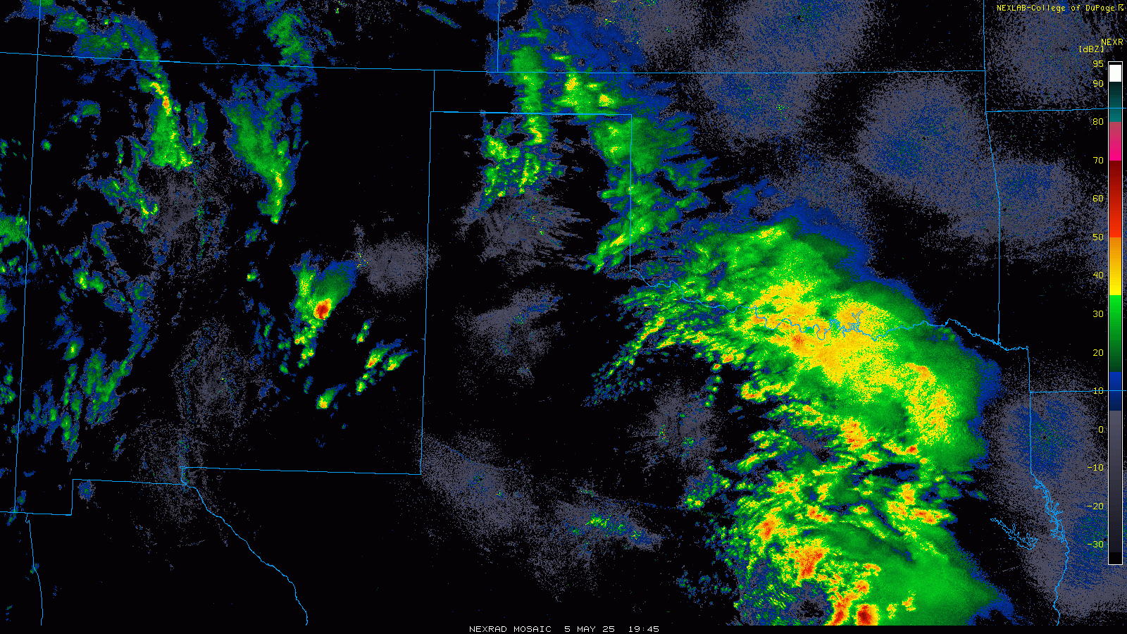
| Regional radar animation valid from 2:05 pm on Monday to 6:25 am on Tuesday (5-6 May 2025). A LBB WSR-88D radar animation, valid from 2:37 am to 7:13 am on Monday (5 May 2025), can be VIEWED HERE. An additional LBB WSR-88D radar animation, valid from 9:58 pm on Monday to 5:19 am on Tuesday, can be FOUND HERE. | |
|
The instigators to the return to the unsettled weather was the approach of a mid/upper level storm system via the Four Corners in combination with improving low-level moisture from the Gulf. Helping to focus the shower and thunderstorm development was a cold front that sagged southward through the region Sunday night into Monday. Returning moisture up and over the frontal zone triggered the development of a band of elevated thunderstorms that tracked from southwest to northeast over much of the South Plains, Rolling Plains and southern Texas Panhandle Monday morning. |
|
 |
|
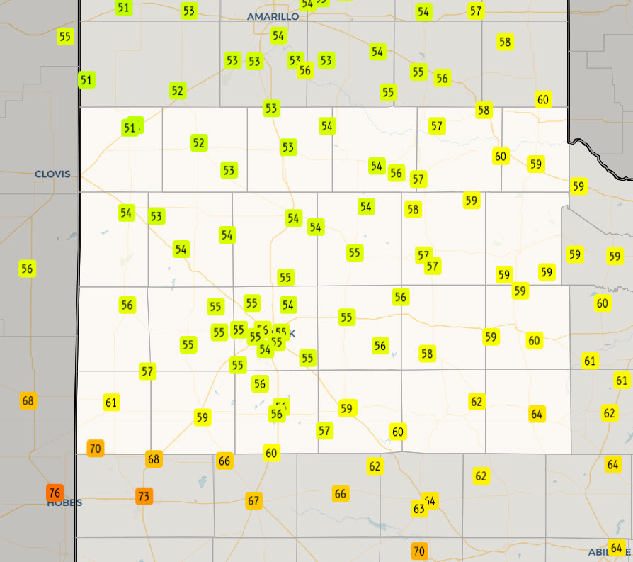
| High temperatures observed on Monday (5 May 2025), courtesy of the West Texas Mesonet (WTM) and COOP observers. | |
|
The morning rain gradually waned, but clouds held firm over much of the region, keeping temperatures on the cool side. Highs only reached the middle to upper 50s over much of the southern Texas Panhandle into the central South and Rolling Plains on Monday. Where sunshine did occur, the far southwest South Plains, around Denver City, was able to warm into the upper 60s and lower 70s. The cool and dreary weather had a positive, in that it limited instability, and thus the intensity of the thunderstorms that moved over the South Plains region late Monday evening into early Tuesday. |
|
 |
|
| "RGB-True Color" satellite loop valid from 8:16 am to 2:56 pm on Monday (5 May 2025). An infrared satellite loop, valid from 4:01 pm on Monday to 5:01 am on Tuesday (5-6 May) can be VIEWED HERE. | |
| Several severe thunderstorms did form south of the cold front, over parts of southeast New Mexico into the Permian Basin, where warmer and more unstable air resided Monday afternoon and evening. Hail as large tennis balls fell in Crane and near Carlsbad. This activity increased in coverage as strong lift from the storm system spread over the southern High Plains Monday night. A few of the stronger cores did generate pockets of small hail (pea to dime size), including over the southwest part of Lubbock, but the main story was the widespread moderate to heavy rainfall. A large shield of rain, with plenty of embedded lightning and thunder, engulfed the South Plains, Rolling Plains and Texas Panhandle through the early morning hours of Tuesday. | |
 |
|
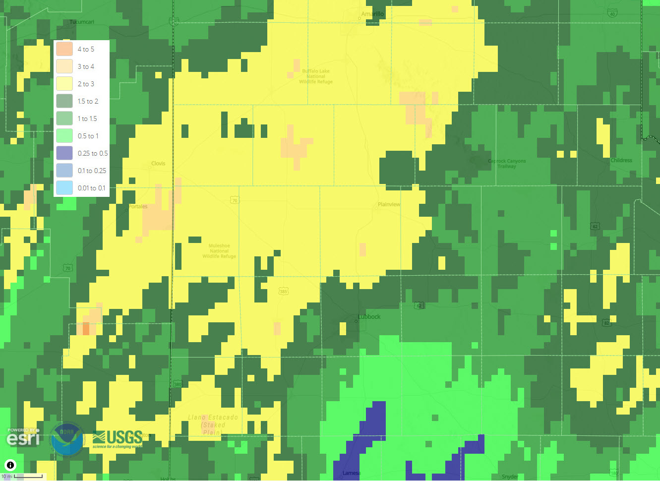
| 48-hour radar-estimated and biased-corrected precipitation ending at 7 am on Tuesday (6 May 2025). | |
|
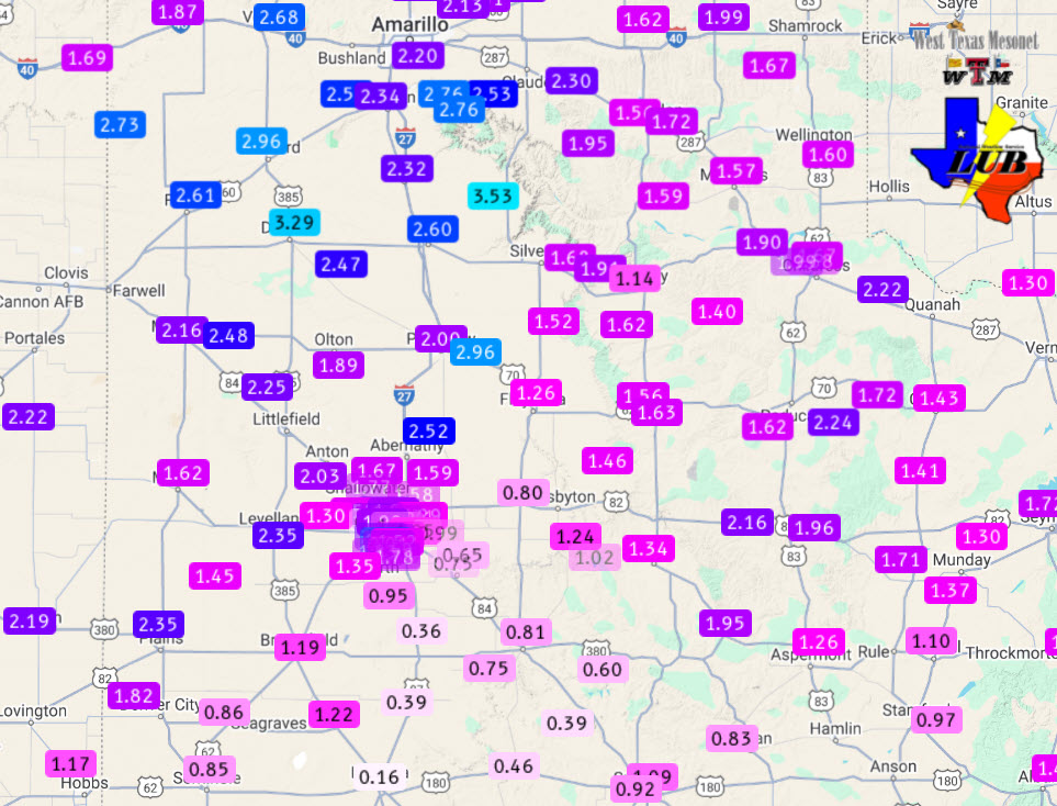
The rain shield gradually shifted over to the north and east Tuesday morning, but not before providing generous rain to the entire region. As the above and below graphics illustrate, significant rain fell across the whole area, with the most generous totals tending to favor locations on the Caprock. Many spots from the southwest and south-central Texas Panhandle through the central and western South Plains recorded rain totals near or above 2 inches. The Dimmitt and Vigo Park WTM sites were the big winners, measuring over 3 inches of rain between Sunday night and Tuesday morning, with the bulk of that falling between Monday morning and Tuesday morning. |
|
 |
|
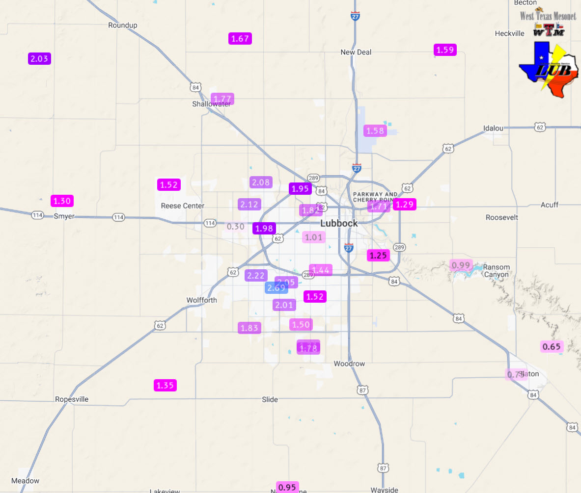
| 48-hour rain totals ending at 11 am on Tuesday (6 May 2025). The data are courtesy of the West Texas Mesonet (WTM) and the National Weather Service. A close up of the Lubbock area can be FOUND HERE. | |
| Officially, the Lubbock Airport tallied 1.76 inches for the early May event, boosting the annual running total to 3.72 inches, which is about four tenths below normal. The Childress Airport measured 1.90 inches over this stretch, raising their year-to-date total to 9.62 inches (or almost 4 inches above normal). The heavy rain did cause some flooding problems, including inundation of many low-lying and poor drainage areas, but the overall negative impacts were minimal. | |
 |
|
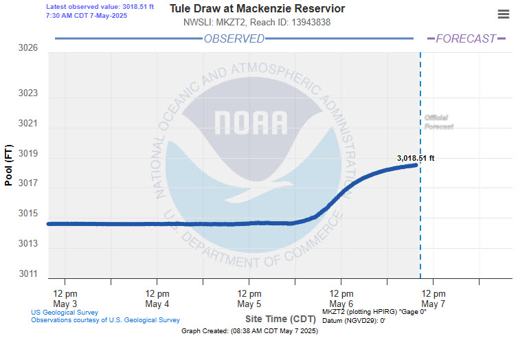
| Mackenzie Reservoir level (ft) plot in early May 2025. | |
| On the positive side, runoff from the widespread rainfall gave another shot to our local rivers, streams and reservoirs. Mackenzie Reservoir rose nearly 4 feet, from 9% of conservation level to 13%. | |

