
Dangerous heat will expand from the Gulf Coast into the Southern Plains and Desert Southwest through week's end. Additional extreme heat impacting the Pacific Northwest will shift to the northern Plains by the weekend. Tropical Storm Bertha is expected to continue to impact portions of the northwestern Gulf Coast from south central Louisiana to the upper Texas coast today. Read More >
(click to enlarge)
|
Maximum Temperature 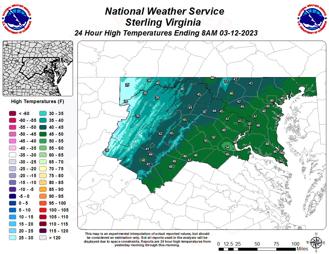 |
Minimum Temperature 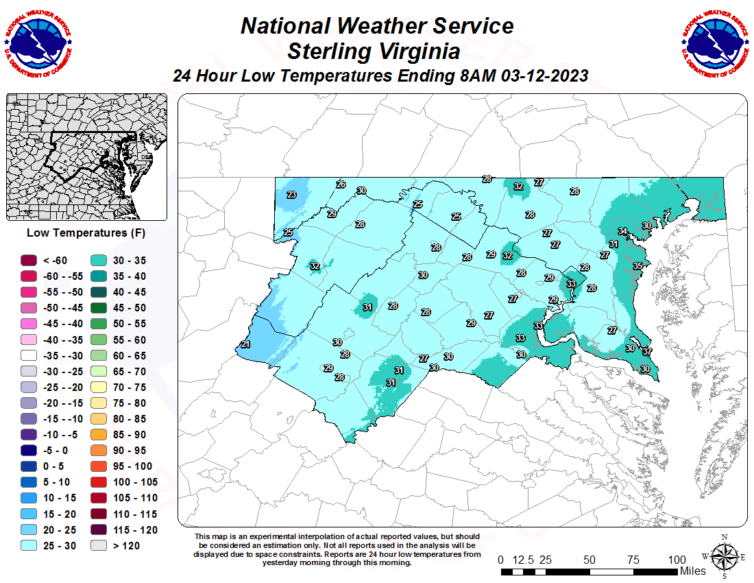 |
|
Rainfall 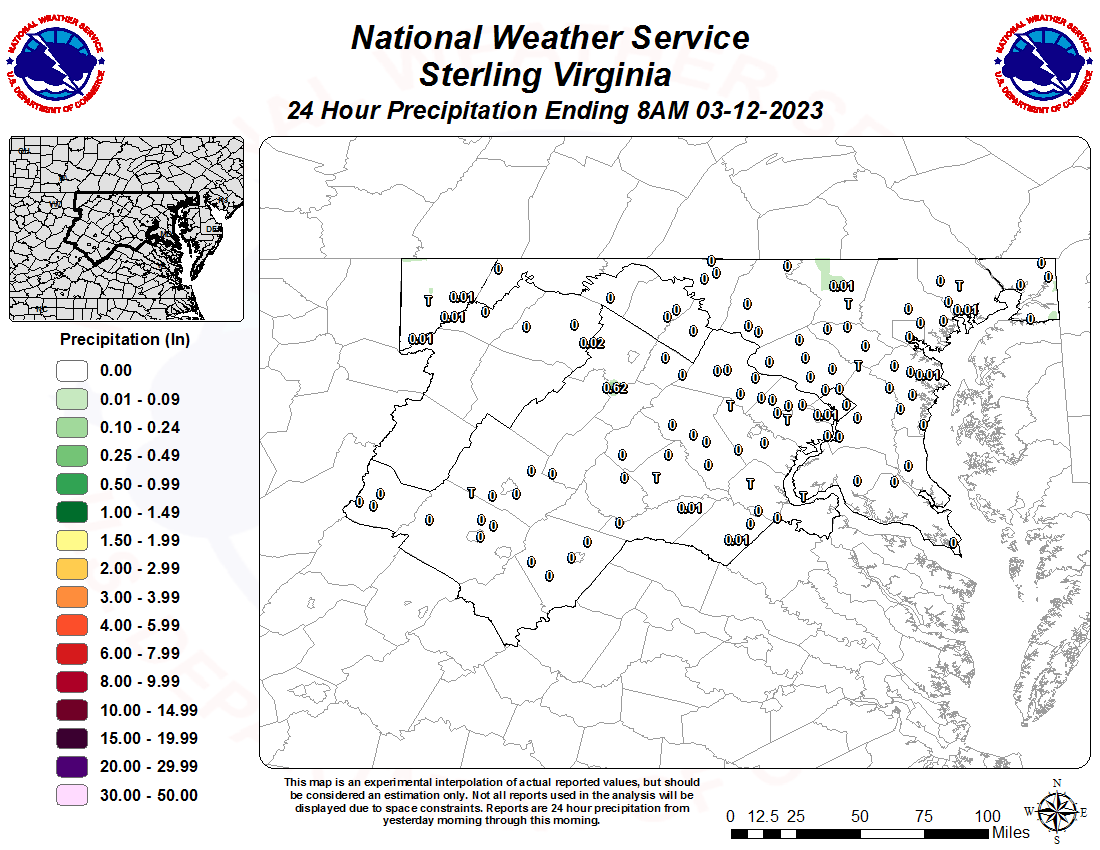 |
Snowfall 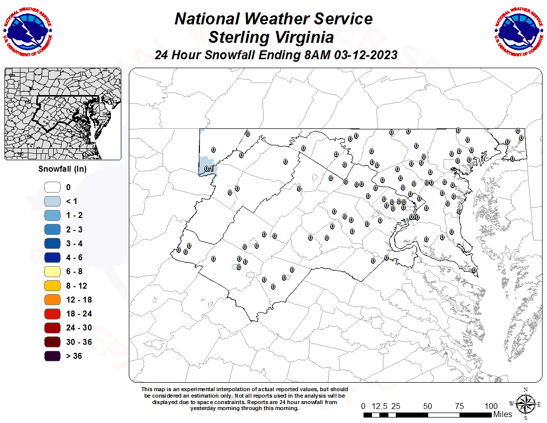 |
321
ASUS61 KLWX 060025
RTPLWX
Max/Min Temperature and Precipitation Table for the Mid-Atlantic
National Weather Service Baltimore MD/Washington DC
825 PM EDT Tue May 5 2026

Values represent highs and lows since 1 AM LST (06 UTC),
and precipitation over the last 24 hours (since 7 PM
LST yesterday).

.BR LWX 0505 ES DH19/TAIRZS/TAIRZI/PPDRZZ
:
:                             Max   Min
:ID        Location          Temp  Temp    Pcpn
:
: First-order and climate sites
BWI  : Balt-Wash Marshall  :   85 /  60 /  0.00
CHO  : Charlottesville AP  :   83 /  51 /    T
DCA  : Reagan National AP  :   86 /  61 /  0.00
DMH  : Baltimore Inner Hrb.:   87 /  58 /  0.00
HGR  : Hagerstown Rgnl AP  :   84 /  59 /    T
IAD  : Dulles Intl Airport :   85 /  58 /  0.00
MRB  : Eastern WV Rgnl AP  :   84 /  58 /  0.00
NAK  : Annapolis Naval Acad:   83 /  59 /  0.00
:
: Climate and COOP network automated sites
CHAV2: Monticello CRN      :   79 /  55 /  0.01
DALV2: Dale Enterprise     :    M /   M /     M
:
: AWOS and military sites
:(precip data may be incomplete or unavailable)
2G4  : Garrett Co Airport  :   72 /  57 /
2W6  : St. Marys Co Rgnl AP:   84 /  62 /  0.00
8W2  : New Market Airport  :   82 /  47 /  0.00
ADW  : Andrews AFB         :    M /   M /     M
APG  : Aberdeen Proving Grd:    M /   M /  0.00
CBE  : Cumberland Rgnl AP  :   83 /  49 /  0.00
CGS  : College Park Airport:   85 /  55 /
CJR  : Culpeper Regional AP:   85 /  57 /  0.00
DAA  : Davison Army Airfld :    M /   M /     M
DMW  : Carroll Co. Rgnl AP :   86 /  59 /
EZF  : Fredericksburg AP   :   86 /  61 /  0.00
FDK  : Frederick Airport   :   84 /  50 /
FME  : Tipton AP/Ft. Meade :   82 /  46 /
FRR  : Front Royal Airport :   82 /  58 /  0.00
GAI  : Gaithersburg Airport:   85 /  59 /  0.00
GVE  : Gordonsville Airport:   84 /  49 /  0.00
HEF  : Manassas Regional AP:   85 /  47 /  0.00
HWY  : Warrenton-Fauquier  :   85 /  48 /  0.00
JYO  : Leesburg Exec AP    :   84 /  55 /
LUA  : Luray Caverns AP    :   82 /  54 /  0.00
MTN  : Martin State AP     :   79 /  59 /
NHK  : Patuxent River NAS  :   85 /  62 /  0.00
NUI  : Webster Naval AP    :   65 /  60 /  0.00
NYG  : Quantico Marine Base:   84 /  62 /  0.00
OKV  : Winchester Rgnl AP  :   81 /  55 /  0.00
OMH  : Orange Co. Airport  :   82 /  52 /  0.00
RMN  : Stafford Rgnl AP    :   86 /  63 /  0.00
SHD  : Shenandoah Rgnl AP  :   80 /  43 /  0.00
VBW  : Bridgewater Air Park:   80 /  53 /  0.00
W13  : Waynesboro Airport  :   81 /  53 /  0.00
W99  : Grant County AP     :   83 /  45 /  0.00
.END

These data are preliminary and have not undergone final quality
control by the Center for Weather and Climate, part of the National
Centers for Environmental Information (NCEI). Therefore, these data
are subject to revision. Final and certified climate data can be
accessed at www.ncdc.noaa.gov.

Additional data from across the area can be found in the
HYDLWX product.

$$


751

SXUS51 KLWX 231405

HYDLWX

Daily Hydrometeorological Data Summary

National Weather Service Baltimore MD/Washington DC

1005 AM EDT Thu Jul 23 2026


:

:Daily Weather Observation Stations...including COOP

:These reports are for a 24 hour period ending at the obs time shown.

.BR LWX 0723 E DH07/TAIRZX/TAIRZN/PPDRZZ/SFDRZZ/SDIRZZ

:

:                            Obs     Max   Min           Snow  Snow

:ID        Location          Time    Temp  Temp   Pcpn   Fall  Depth

:

:Eastern West Virginia...

:

:Berkeley County...

HEDW2 : Hedgesville       : DH0700/     /     /     M/      /

MRTW2 : Martinsburg COOP  : DH0700/  86 /  58 /  0.00/      /

MTGW2 : Martinsburg RAWS  : DH0813/  85 /  60 /  0.00/      /

RDTW2 : Round Top         : DH0600/     /     /     M/      /

:Grant County...

BAYW2 : Bayard COOP       : DH0700/  76 /  53 /  0.00/   0.0/    0

MNSW2 : Mount Storm       : DH0800/     /     /  0.00/      /

RDCW2 : Red Creek         : DH0800/     /     /  0.00/      /

:Hampshire County...

DELW2 : Delray            : DH0500/     /     /     M/      /

LCMW2 : Little Cacapon Mt.: DH0500/     /     /     M/      /

NATW2 : Nathaniel Mountain: DH0815/  82 /  56 /  0.11/      /

ROMW2 : Romney COOP       : DH0700/  83 /  57 /  0.00/     M/    M

THKW2 : Thrasher Knob     : DH0200/     /     /     M/      /

:Hardy County...

EHRW2 : Elkhorn Rock      : DH0300/     /     /     M/      /

:Jefferson County...

BDNW2 : Bardane           : DH0300/     /     /     M/      /

SHAW2 : Shannondale       : DH0900/     /     /     M/      /

:Mineral County...

BLMW2 : Bloomington Lake  : DH0800/  80 /  57 / /      /

FOUW2 : Fountain          : DH0500/     /     /     M/      /

:Morgan County...

BSGW2 : Berkeley Springs  : DH0500/     /     /     M/      /

CPNW2 : Ridge             : DH0800/     /     /  0.00/      /

PAWW2 : Paw Paw           : DH0900/     /     /     M/      /

UNGW2 : Unger             : DH0700/     /     /     M/      /

:Pendleton County...

MTCW2 : Mitchell Mountain : DH0900/     /     /     M/      /

ONEW2 : Onego             : DH0800/     /     /  0.00/      /

SPBW2 : Spruce Knob       : DH0801/  65 /  45 /  0.00/      /

UPTW2 : Upper Tract       : DH0817/  83 /  60 /  0.00/      /

WHCW2 : White Horn Creek  : DH0200/     /     /     M/      /

:

:Western, Central, and Southern Maryland...

:

:Allegany County...

GRDM2 : Green Ridge       : DH0819/  83 /  54 /  0.00/      /

CBEM2 : South Cumberland  : DH0800/     /     /  0.00/      /

:Anne Arundel County...

:Baltimore County...

WSVM2 : Westview          : DH0800/     /     /  0.00/      /

:Calvert County...

:Carroll County...

:Cecil County...

CHCM2 : Chesapeake City   : DH0800/  87 /  65 /      /      /

FAHM2 : Fair Hill DEOS    : DH0800/  87 /  58 /  0.00/      /

NOEM2 : North East DEOS   : DH0800/  87 /  63 /  0.00/      /

:Frederick County...

FOXM2 : Catoctin Mtn RAWS : DH0754/  81 /  54 /  0.00/      /

:Garrett County...

KITM2 : Kitzmiller        : DH0800/     /     /  0.00/      /

SRDM2 : Savage River Dam  : DH0800/  81 /  61 /  0.00/     M/    M

:Harford County...

APG   : Aberdeen COOP     : DH0700/  89 /  64 /  0.00/   0.0/    0

CRGM2 : Churchville       : DH0700/     /     /  0.00/      /

FALM2 : Fallston          : DH0700/     /     /  0.00/      /

NRGM2 : Norrisville       : DH0700/     /     /  0.00/      /

SSQM2 : Susquehanna St Pk : DH0825/  89 /  62 /  0.00/      /

WRGM2 : Whiteford         : DH0700/     /     /  0.00/      /

:Howard County...

CGWM2 : Columbia Gateway  : DH0700/     /     /  0.00/      /

ELKM2 : Elkridge          : DH0700/     /     /  0.00/      /

ELYM2 : Ellicott City     : DH0700/     /     /  0.00/      /

:Montgomery County...

CKPM2 : Clarksburg        : DH0700/     /     /  0.00/      /

DMAM2 : Damascus COOP     : DH0700/  85 /  58 /  0.00/   0.0/    0

TMPM2 : Ten Mile Creek    : DH0700/     /     /  0.00/      /

:Prince Georges County...

PWDM2 : Beltsville        : DHM   /   M /   M /  0.00/      /

BLDM2 : Bladensburg       : DH0700/     /     /  0.00/      /

GRNM2 : Greenbelt         : DH0700/     /     /  0.00/      /

HTNM2 : Largo             : DH0700/     /     /  0.00/      /

UPRM2 : Upper Marlboro    : DH0700/     /     /  0.00/      /

:St. Mary`s County...

:Washington County...

ANBM2 : Antietam Battlefl.: DH0813/  85 /  57 /  0.01/      /

PDFM2 : Dam Number Five   : DH0700/     /     /  0.00/      /

WLLM2 : Williamsport COOP : DH0700/     /     /  0.00/      /

:Baltimore City...

IHBM2 : Harbor East       : DH0300/     /     /     M/      /

NBDM2 : Northbend         : DH0800/     /     /  0.00/      /

:

:District of Columbia...

:

NARD2 : Nat Arboretum COOP: DH0630/  84 /   M /  0.00/     M/    M

WASD2 : DC SW Waterfront  : DH0800/  91 /  69 /      /      /

:

:Northern and Central Virginia...

:

:Albemarle County...

:Arlington County...

AFRV2 : Four Mile Run     : DH0800/     /     /  0.00/      /

:Augusta County...

CROV2 : Sawmill Ridge     : DH0735/  91 /  60 /  0.00/      /

SHDV2 : Steeles Tavern    : DH0800/  86 /  62 /  0.00/      /

:Fairfax County...

DNLV2 : Vienna COOP       : DH0700/  85 /  61 /  0.00/   0.0/    0

:Fauquier County...

:Highland County...

MILV2 : Millgap COOP      : DH0600/  79 /  55 /  0.00/   0.0/    0

:King George County...

NCDV2 : Dahlgren          : DH0800/  89 /  66 /      /      /

:Loudoun County...

LSGV2 : Leesburg          : DH0800/     /     /  0.00/      /

LVRV2 : Lovettsville      : DH0800/     /     /  0.00/      /

:Madison County...

:Nelson County...

:Orange County...

NPAV2 : Piedmont Research : DH0800/  90 /  66 /  0.22/      /

SOMV2 : Somerset COOP     : DH0800/  91 /  64 /  0.40/     M/    M

:Page County...

LHQV2 : National Park HQ  : DH0746/  88 /  56 /  0.00/      /

:Prince William County...

PWRV2 : PW Forest Park    : DH0736/  91 /  65 /  0.06/      /

:Rappahannock County...

:Rockingham County...

:Shenandoah County...

FVRV2 : Fort Valley       : DH0732/  89 /  56 /  0.00/      /

:Warren County...

FRRV2 : Front Royal COOP  : DH0600/  88 /  63 /  0.00/     M/    M

:City of Alexandria...

ABPV2 : Boothe Park       : DH0500/     /     /     M/      /

:City of Staunton...

STAV2 : Staunton COOP     : DHM   /   M /   M /  0.00/   0.0/    0

:City of Waynesboro...

JHDV2 : Jones Hollow Dam  : DH0800/     /     /  0.00/      /

:

.END


These data are preliminary and have not undergone final quality

control by the Center for Weather and Climate, part of the National

Centers for Environmental Information (NCEI). Therefore, these data

are subject to revision. Final and certified climate data can be

accessed at www.ncdc.noaa.gov.


The data shown in this product are provided by dedicated cooperative

observers...the USGS...local county observation networks...Virginia

Tech University...the US Army Corps of Engineers...the USDA...and the

Bureau of Land Management. The NWS thanks these cooperators for their

vital information.

$$


 Coastal Flood
 FAQ
FAQ