
Dangerous, record-breaking heat will continue across most of the central and eastern U.S through Friday then focusing across the eastern U.S. through the Independence Day holiday weekend. Peak heat indices of up to 115 degrees are possible. Isolated to scattered severe thunderstorms are possible from the northern/central Plains into the Midwest, Ohio Valley, and Mid-Atlantic Friday. Read More >
The information presented below is preliminary and subject to correction.
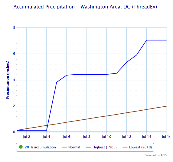
Through the first 15 days of July (and in fact, the 16th also), only a trace of rain was observed at Reagan National Airport. This is the only time on record, dating back to 1871, that no measurable rain fell in the first 15 days of July. The old low benchmark of 0.08" was set in 1900. Normal rainfall for the first 15 days of July is 1.86 inches, and back in 1905, the wettest first 15 days of July brought 7.05" of rain. These extremes are shown in the graph below.
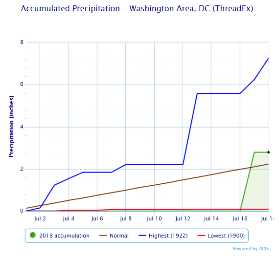
Then, on July 17th, that all changed almost in an instant. Torrential rain moved directly over the airport and the city. Preliminary numbers show 2.63 inches of rain falling in just 46 minutes. 0.95" fell in just 11 minutes. The total rain for the day was 2.79", not just wiping out the rainfall deficit for the month, but turning it to a surplus.
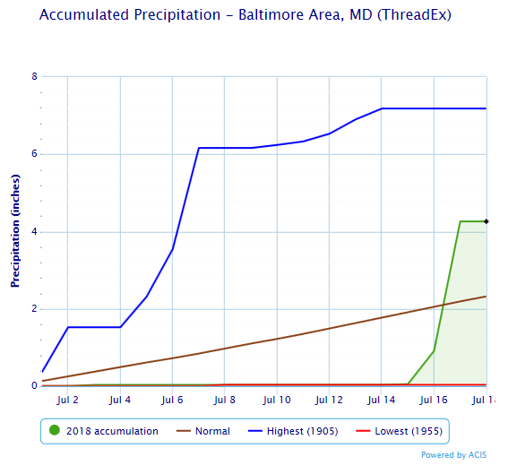
At Baltimore (BWI Airport), there were a couple days with light rain in the first half of the month, so the total of 0.05" through the 15th is not the driest on record (0.03" from 1955). Things started to turn around a little sooner at BWI than at DCA. On the 16th, 0.86" fell, which cut the rainfall deficit for July nearly in half. Another 3.35 inches of rain fell on the 17th, not just wiping out the rest of the July rainfall deficit, but sending that location to almost twice what is normal.


 Coastal Flood
 FAQ
FAQ