
Numerous severe thunderstorms are expected across a broad region from the Ohio Valley to the Mid-Atlantic and Northeast States today into tonight. Swaths of damaging wind gusts are expected and some tornadoes are possible. Bertha is expected to bring tropical storm conditions to portions of the Gulf Coast from the Florida Panhandle westward to southeastern Louisiana later today and Wednesday. Read More >
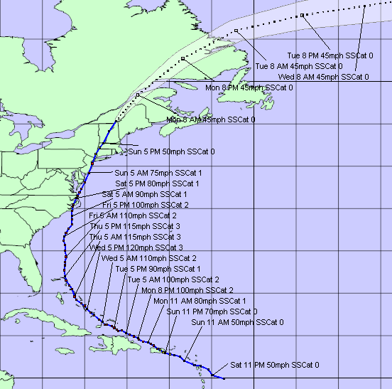
Hurricane Irene affected the Mid-Atlantic region on Saturday, August 27 through Sunday, August 28, 2011. The tropical cyclone was named a week prior on August 20, 2011 as the tropical wave was entering the eastern Caribbean. The cyclone was upgraded to a hurricane just before affecting Puerto Rico on Au-gust 21st. They cyclone then turned northwest and then north, paralleling the eastern seaboard of the United States, eventually making landfall near Cape Lookout, North Carolina on the morning of the 27th as a Category 1 Hurricane with maximum sustained winds near 85 mph. Irene then travelled northeast, paralleling the Mid-Atlantic coast. The center of the cyclone passed less than 15 miles off the coast of Ocean City just after 2 AM on August 28th, and then made a second landfall near Little Egg Inlet, New Jersey around 5:35 am. Eventually, Irene weakened to a tropical storm as it moved over New York City around 9 AM.
Locally, Irene will be remembered for producing extensive tree damage due to its strong gusty winds and for its heavy rainfall. At the storm’s peak, several area airports briefly recorded minimal sustained tropical storm-force winds of 34 mph, including Washington-Reagan National and Patuxent River Naval Air Station (NAS); both measured sustained 41 mph winds, while 39 mph sustained winds were measured at both Martin State and Andrews Air Force Base. Wind gusts of 50 mph and higher were common along and east of the I-95 corridor, including a 64 mph gust at Patuxent River NAS, and 60 mph gusts at both Reagan National Airport and Quantico Marine Corp Base. Over area waters, even higher wind gusts were reported including the Maryland portion of the Chesapeake Bay. A 73 mph gust was measured in the Bay at Cove Point east of Calvert County, Maryland, and 71 mph gusts were reported at both Thomas Point Lighthouse and at the Francis Scott Key Bridge over the Patapsco River in Baltimore.
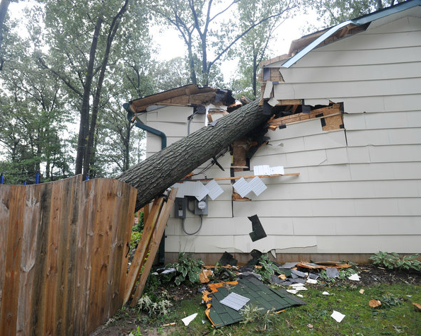
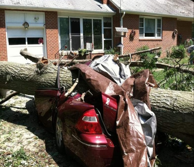
Communities across southern Maryland and along the western shoreline of the Chesapeake Bay received the largest impact, although minor impacts extended west all the way to the Blue Ridge Mountains. Fallen trees damaged nearly 1,000 homes primarily across southern Maryland, with nearly two dozen homes being destroyed. In addition, the wind and fallen trees resulted in nearly 2.5 million power outages in Virginia, and around 850,000 in Maryland and the District of Columbia. The number of power outages in Virginia was the second highest in Virginia history – just behind Isabel in 2003. Early damage estimates in the days following the storm topped $13 million in northern Virginia and central and southern Maryland.
In terms of rainfall, a swath of 5-10 inches of rainfall was reported to the west of the storm track (see map). Communities east of Baltimore and Washington were within that area. Between the Blue Ridge and Interstate 95, rainfall totals generally fell between 2 and 4 inches, although it was lower in the Catoctin Mountains in north central Maryland. BWI Airport measured 4.69” while Washington’s Reagan National airport measured just under 4 inches (3.83”). The highest report within northern Virginia and central & southern Maryland came from Leonardtown, Maryland where 11.52 inches of rain fell. Overall, St. Mary’s County Maryland received the heaviest rainfall, averaging between 8 and 11 inches. Numerous roads were closed due to flooding from the heavy rainfall, primarily east of Interstate 95. In addition, the river gauge on St. Clement Creek near Clements, Maryland in St. Mary’s County set a new record level of 6.98 feet. Records at this location date back to 1968.
|
Storm damage in Lexington Park, MD |
Storm Damage in Severna Park, MD |
 |
Text Products:
Rainfall:
 Rainfall |
|
Maximum Wind Gusts:
 Maximum Wind Gusts |
|


 Coastal Flood
 FAQ
FAQ