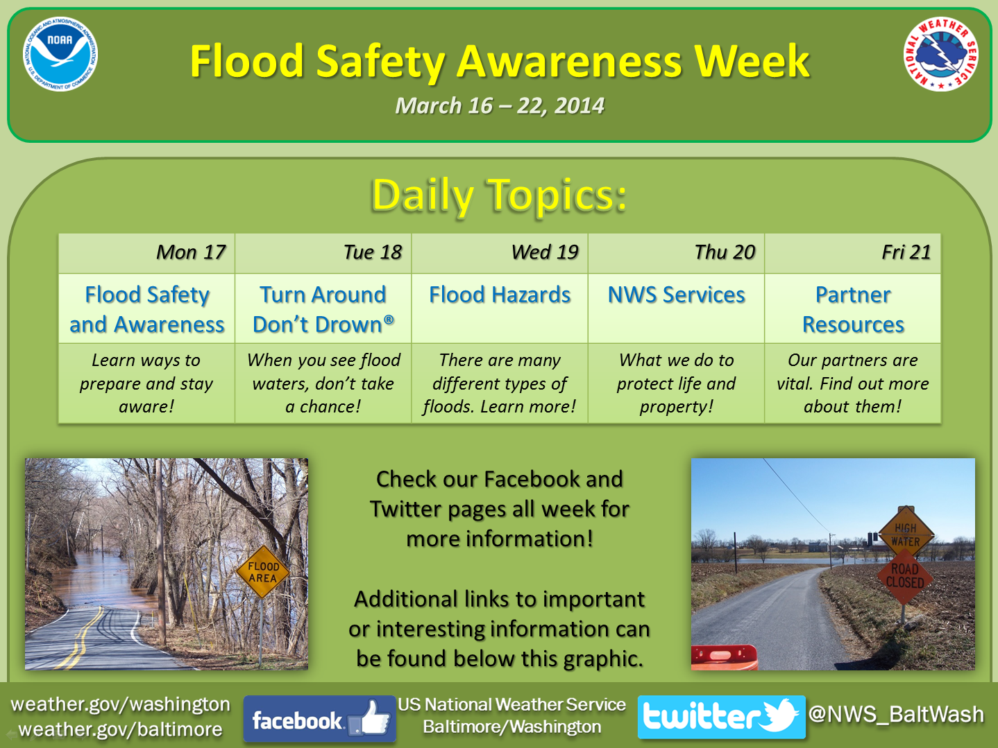
Monday, March 17th
Flood Safety - Preparedness and Awareness
Nearly every day, flooding happens somewhere in the United States or its territories. Flooding can occur here in the mid-Atlantic region at any time of the year. It causes more damage in the United States than any other weather related event. On average, floods cause eight billion dollars in damages and ninety five fatalities annually nationwide. Being prepared and knowing how to stay safe will help you and your loved ones survive a flood.
To be prepared and aware, learn your answers to the following questions:
To find out, visit the following websites, depending on where you live:
In West Virginia, visit https://www.mapwv.gov/flood/ .
In Maryland, visit https://www.mdfloodmaps.com/.
In the District of Columbia, visit https://ddoe.dc.gov/floodplainmap.
In Virginia, visit https://rfris.nc.gov/fris/?ST=VA
Find out which flooding hazards impact our area by clicking on your state at www.floodsafety.noaa.gov/map.shtml.
The easiest way to determine this is to pay extra attention to your surroundings when driving before a storm? Is there a significant downhill slope prior to a stream? Do you cross a low-water bridge?
Visit our website anytime at https://weather.gov/washington to see the latest watches and warnings that are in effect for your area. You can also obtain watches and warnings through NOAA Weather Radio or a number of other non-government sources.
Our office issues river forecasts for dozens of locations in the mid-Atlantic region. You can see the latest river forecasts at https://water.weather.gov/ahps2/forecasts.php?wfo=lwx. The sites denoted by circles have an updated forecast at least once per day.
Our office issues precipitation amount forecasts for the first three days. You can see our latest precipitation forecasts for your community by clicking on the map at https://forecast.weather.gov/afm/graphical.php?site=lwx . The NWS Weather Prediction Center (WPC) issues precipitation forecasts to seven days. Their website is http://www.wpc.ncep.noaa.gov.
See some of the historic floods from each state at www.floodsafety.noaa.gov/map.shtml. Talk to your neighbors, or contact your local community officials, to find out about past floods in your neighborhood.
For our major rivers, you can obtain a complete flood history from our River Forecast Center at https://www.erh.noaa.gov/marfc/Rivers/FloodClimo/.
Later this week, on Wednesday, we will discuss causes of floods in the mid-Atlantic. See Wednesday’s section for more information.
For example, have retention ponds, levees, or floodwalls been built? Take a look around your neighborhood – these are easy to find!
Tuesday, March 18th
Turn Around Don’t Drown
Turn Around Don’t Drown, or TADD for short, is a NOAA National Weather Service campaign used to educate people about the hazards of driving a vehicle or walking through flood waters.
This year is the 10th anniversary of the TADD program. Hundreds of signs depicting the message have been erected at low water crossings during the past decade. The phrase “Turn Around Don’t Drown” has become a catchphrase in the media, classroom, and even at home. It’s one thing to see or hear the phrase, and another to put it into practice.
Flooding is the 2nd leading cause of weather related fatalities in the U.S. (behind heat). On average, flooding claims the lives of 95 people each year. Most of these deaths occur in motor vehicles when people attempt to drive through flooded roadways. Many other lives are lost when people walk into flood waters. This happens because people underestimate the force and power of water, especially when it is moving. The good news is most flooding deaths are preventable with the right knowledge.
Just six inches of fast-moving water can knock over an adult. Only eighteen inches of flowing water can carry away most vehicles, including large SUVs. It is impossible to tell the exact depth of water covering a roadway or the condition of the road below the water. This is especially true at night when your vision is more limited. It is never safe to drive or walk through flood waters. Any time you come to a flooded road, walkway, or path, follow this simple rule: Turn Around Don’t Drown.
For more information on the TADD program, visit https://tadd.weather.gov.
For flood safety tips, visit www.floodsafety.noaa.gov.
Wednesday, March 19th
Flood Hazards
A flood is defined as any high flow, overflow, or inundation of water that causes or threatens damage. Flooding can occur with prolonged rainfall over several days, intense rainfall over a short period of time, or when water from an existing source moves too quickly (i.e. snowmelt, dam break, etc.). Brief descriptions of the various types of flooding you may experience are found below. More information about these flood hazards can be found on the NWS Flood Safety Website at www.floodsafety.noaa.gov.
Flash Flooding: Flash flooding is a rapid and extreme flow of high water into a normally dry area, or a rapid water level rise in a stream or creek above a predetermined flood level, beginning within six hours of the event which caused it.
River Flooding: River flooding occurs when rivers rise and overflow their banks, inundating areas that are normally dry.
Tropical Systems and Coastal Flooding: At any time of year, a storm from over the ocean can bring heavy precipitation to the U.S. coasts. Whether such a storm is tropical or not, prolonged periods of heavy precipitation can cause flooding in coastal areas, as well as further inland as the storm moves on shore. Additionally, surge from these storms can inundate coastal areas.
Burn Scars/Debris Flows: Although not as common in the mid-Atlantic as other parts of the country, wildfires do occur in this region, burning away the vegetation of an area, leaving behind bare ground that tends to repel water. When rain falls, it runs off a burn scar towards a low lying area, sometimes carrying branches, soil and other debris along with it. Without vegetation to hold the soil in place, flooding can produce mud and debris flows.
Snowmelt: Flooding due to snowmelt most often occurs in the spring when warming temperatures quickly melt the snow. The water runs off the still partially frozen or already saturated ground into nearby streams and rivers, causing them to rapidly rise and sometimes overflow their banks.
Ice and Debris Jams: A backup of water into surrounding areas can occur when a river or stream is blocked by a build-up of ice or other debris.
Dam Break and Levee Failure: A break or failure can occur with little to no warning. Most often they are caused by water overtopping the structure, excessive seepage through the surrounding ground, or a structural failure.
Understanding the different flood hazards and knowing the actions to take before, during, and afterwards can help you protect your life, the lives of your loved ones, and your property. Prepare now by visiting www.floodsafety.noaa.gov
Thursday, March 20th
National Weather Service Water Resources
Our homepage, https://weather.gov/washington, provides up to date weather and water advisory, watch, and warning information for the mid-Atlantic region. However, the NWS provides many additional resources to help emergency managers, public officials and private citizens make water decisions.
Advanced Hydrologic Prediction Service (AHPS)
AHPS provides a suite of river and flood forecasts and water information to protect life and property and helps ensure the nation’s economic well-being. https://water.weather.gov/ahps2/index.php?wfo=lwx
Flood Inundation Mapping
The ability to look into the future to see how many city blocks and roads might be flooded is becoming clearer with flood inundation mapping. Although inundation mapping does not exist in the mid-Atlantic region yet, it is quickly being added throughout the country, and efforts are ongoing to provide such maps here. https://water.weather.gov/ahps/inundation.php
Weather Prediction Center (WPC) Precipitation Forecasts
WPC provides precipitation forecasts for the entire U.S. WPC also issues excessive rainfall forecasts, short-range discussions on heavy rainfall events, and snowfall and freezing rain probabilities. www.wpc.ncep.noaa.gov/
NWS River Forecast Centers (RFCs)
The National Weather Service has a network of thirteen RFCs across the United States. These RFCs collect, process, and provide water resource and river forecasts and information for major river basins across the country. https://water.weather.gov/ahps/rfc/rfc.php
Decision Support
As part of our effort to develop a Weather-Ready Nation, we provide decision support services to core partners ahead of a potential flood. This includes briefing these partners on expected weather and water conditions, and providing them information necessary to make decisions to protect lives and property.
Flood Safety Awareness Website
On this page, you will find information on what to do before, during and after a flood. www.floodsafety.noaa.gov
Friday, March 21st
Partner Resources
The National Weather Service works with and relies on strategic partners involved in river observations, reservoir management, floodplain management, flood hazard mitigation, and flood preparedness and safety to reduce the loss of life and property due to floods. Today we are sharing some great tools from several of our partners.
American Red Cross
Family Disaster Plan: www.redcross.org/prepare/location/home-family
Federal Alliance for Safe Homes (FLASH)
Flood Safety Information: www.flash.org/peril_flood.php
Federal Emergency Management Agency (FEMA)
Safety Information: www.ready.gov.
Safety Kit Assembly: www.ready.gov/build-a-kit
Property Protection and Flood Insurance: www.floodsmart.gov.
Assess Your Flood Risk: https://msc.fema.gov.
United States Army Corps of Engineers
Flood Information: https://www.usace.army.mil/Missions/EmergencyOperations/Floods.aspx
United States Geological Survey
Water Watch: https://waterwatch.usgs.gov/index.php?id=ww
Water Alert - National Water Information System: https://maps.waterdata.usgs.gov/mapper/wateralert/
The National Weather Service works with many key partners to complete the mission of protecting life and property. Some additional key partners are the National Hydrologic Warning Council, Association of State Floodplain Managers, the National Safety Council, media outlets, and many other government and private sector organizations. For more information about any of our partners, or to learn about partners local to your area, contact your local NWS office.
Remember, flooding can occur at any time of the year. Prepare yourself, your family, and your home. Be aware of potential flooding in your area, Turn Around Don’t Drown, and help make the U.S. a more Weather Ready Nation! http://www.nws.noaa.gov/com/weatherreadynation/


 Coastal Flood
 FAQ
FAQ