National Weather Service United States Department of Commerce
Click a location below for detailed forecast.

Last Map Update: Thu, May. 2, 2024 at 4:02:53 pm CDT

National Weather Service Tulsa, OKNational Weather Service Springfield, MONational Weather Service Paducah, KY
National Weather Service Norman, OKZoom
Out

National Weather Service Memphis, TN
National Weather Service Fort Worth/Dallas, TXNational Weather Service Shreveport, LANational Weather Service Jackson, Mississippi

Here is a regional radar view.
Scattered to numerous showers and thunderstorms are expected through the weekend. The forecast calls for one to more than two inches of rain in Arkansas, with the highest amounts in southern sections of the state.
The latest drought monitor has been issued and there is not a lot of difference from what we were looking at last week.
On this day in 2008, fourteen tornadoes were spawned. One of the tornadoes tracked from Birdtown (Conway Co) to just north of Damascus (Van Buren Co) to Greer's Ferry (Cleburne Co), and claimed the lives of 5 people. In total, 7 lives were lost from these storms.
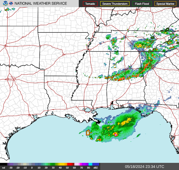
Heavy rain fell from April 30th to May 3rd, 2011. This led to flash flooding and helped contribute to a major flood event in May across Arkansas.
The National Weather Service will be teaching both basic and advanced spotter training this Saturday, May 4th, in Ash Flat. Come Join us. Its free to all.

 
Hourly Weather Roundup ( )
Location Sky/Weather Temp Dewpt RH Wind Baro Remarks
Fayetteville
N/A
N/A
N/A
N/A
N/A
N/A
N/A
Harrison
N/A
N/A
N/A
N/A
N/A
N/A
N/A
Mountain Home
N/A
N/A
N/A
N/A
N/A
N/A
N/A
Jonesboro
N/A
N/A
N/A
N/A
N/A
N/A
N/A
Fort Smith
N/A
N/A
N/A
N/A
N/A
N/A
N/A
Russellville
N/A
N/A
N/A
N/A
N/A
N/A
N/A
Mount Ida
N/A
N/A
N/A
N/A
N/A
N/A
N/A
Hot Springs
N/A
N/A
N/A
N/A
N/A
N/A
N/A
Little Rock
N/A
N/A
N/A
N/A
N/A
N/A
N/A
North Little Rock
N/A
N/A
N/A
N/A
N/A
N/A
N/A
West Memphis
N/A
N/A
N/A
N/A
N/A
N/A
N/A
Texarkana
N/A
N/A
N/A
N/A
N/A
N/A
N/A
El Dorado
N/A
N/A
N/A
N/A
N/A
N/A
N/A
Pine Bluff
N/A
N/A
N/A
N/A
N/A
N/A
N/A
Monticello
N/A
N/A
N/A
N/A
N/A
N/A
N/A
Note: "N/A" or "MISG" will be displayed if values are not available. In the LOCATION column, click on links for a list of recent observations at sites of interest. In the WIND column, VRB is "variable" and G is "gust". Wind speeds are in MPH. In the BARO (pressure) column, values are in inches. In the REMARKS column, HX is "heat index", WCI is "wind chill index", and VSB is "visibility" (if shown).
 
 
Point Forecasts
Cities in Arkansas Coordinates (make sure "Lon" is negative)
Lat:   Lon:
 
Local Hazards
Local Hazards
Decision Support
Decision Support
Submit Storm Report
Submit Storm Report
Local Forecast Page
Local Forecast Page
Radar Links
Radar Links
Local Climate Page
Local Climate Page
Local Observations Page
Local Satellite Page
Local Drought Page
Local Drought Page
Local Hydrology Page
Local Fire Page
Local Fire Page
Text Product Viewer
Text Product Viewer