 |
| Product Notice |
| The following radar products are available in "Z" or "Coordinated Universal Time." |
|
| |
|
To go from "Z" time to Central Daylight Time (CDT), subtract 5 hours (2145Z is 1645 or 445 pm CDT). To go to Central Standard Time (CST), subtract 6 hours (2145Z is 1545 or 345 pm CST). For more about "Z" time, click here.
|
|
|
 |
Radar Data |
 |
| |
 Radar Data Links Radar Data Links |
| |
|
|
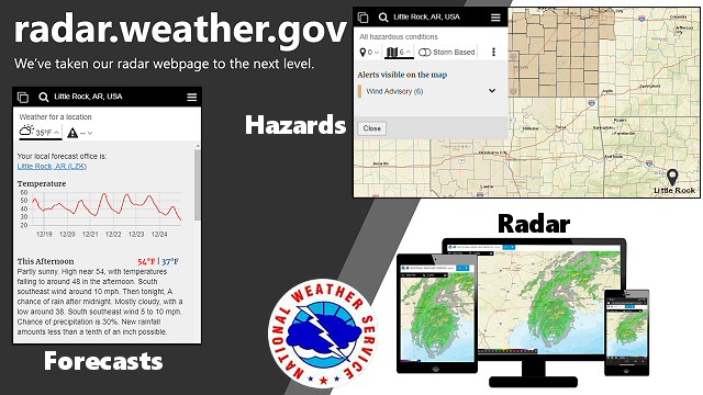
| In the picture: The new National Weather Service radar interface (officially released on December 17, 2020) will do a lot more than show where it is raining. |
| |
| New Radar Interface (Enhanced) |
| Note: At times, enhanced radar images may load and/or loop slowly (mainly based on internet traffic). If that is the case, try the standard radar links or "Other Radar Resources" below. |
| User Guide/Feedback |
| WSR-88D (Little Rock, AR) |
WSR-88D (Fort Smith, AR) |
| WSR-88D (Shreveport, LA) |
WSR-88D (Jackson, MS) |
| WSR-88D (Memphis, TN) |
WSR-88D (Springfield, MO) |
| WSR-88D Data From Individual Radars |
| WSR-88D Regional Radar Mosaic |
| WSR-88D National Radar Mosaic |
| |
| New Radar Interface (Standard) |
| WSR-88D (Little Rock, AR) |
WSR-88D (Fort Smith, OK) |
| WSR-88D (Shreveport, LA) |
WSR-88D (Jackson, MS) |
| WSR-88D (Memphis, TN) |
WSR-88D (Springfield, MO) |
| National Mosaic: Small | Large |
Regional Mosaic |
| |
|
|
| In the picture: Here is a quick regional radar loop from the last hour or so (assuming data is available) . Times (in the lower right corner) are in UTC or "Z". For more information about "Z" time, click here. |
| |
| Other Radar Resources |
| WSR-88D Local Radar Mosaic (MRMS) |
WSR-88D National Radar Mosaic (MRMS) |
| WSR-88D Regional Radar Mosaic (MRMS) |
WSR-88D Archived Images (NCEI) |
|
|