 |
| Storm Reports |
| Are you interested in what happened during a recent event? Check out the report below. |
|
|
 |
Heavy Rain/Severe Storms on May 9-12, 2023 |
 |
| |
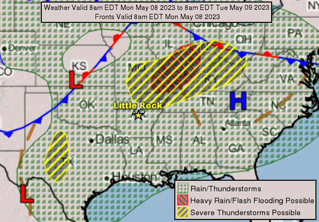 |
| In the picture: A cold front approached Arkansas from the Plains on 05/08/2023. The front triggered severe storms in northern Arkansas before dawn the next morning. |
|
| |
|
After a mild start/below average temperatures to begin May, there was a quick transition to summerlike conditions by the 6th. Thermometers showed readings in the 80s to lower 90s, and this continued for several days. Early on the 9th, a cold front drifted into Arkansas from Missouri, and encountered a warm and energized environment. Scattered strong to severe thunderstorms popped up, and deposited large hail in places. Quarter size hail was reported on the southeast side of Jonesboro (Craighead County) and at Tyronza (Poinsett County).
|
 |
The Pattern at 700 am CDT (05/10) | The Pattern at 700 pm CDT (05/10)
The Pattern at 700 am CDT (05/11) | Loop |
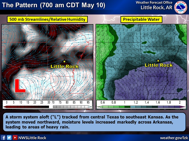
| In the pictures: A storm system aloft ("L") tracked from central Texas to southeast Kansas. As the system moved northward, moisture levels increased markedly across Arkansas. Surrounding the system, several mesoscale convective vortices (MCVs) from decaying thunderstorms in the southern Plains helped spark new storms. These storms produced pockets of heavy to excessive rain, strong to damaging winds, and isolated tornadoes. The data is courtesy of the College of DuPage. |
|
| |
|
The front stalled across the northern counties, and the focus shifted to a storm system headed this way from Texas on the 10th/11th. As the system approached, moisture levels went through the roof. Precipitable water (or water vapor contained in a vertical column of the atmosphere) values climbed to 1.76 inches on the morning of the 11th at the North Little Rock Airport (Pulaski County). This was well above the normal between 1.00 and 1.25 inches. Storm clouds had more than usual moisture to wring out, making them more efficient rain makers.
|
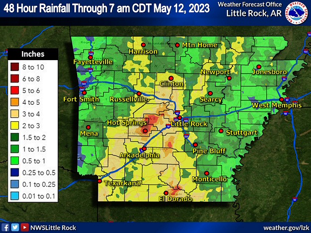 |
| In the picture: Forty eight hour rainfall through 700 am CDT on 05/12/2023. |
|
| |
|
Two to more than four inches of rain dumped from southwest into central sections of the state. In the forty eight hour period ending at 700 am CDT on the 12th, Hot Springs National Park (Garland County) received 6.44 inches of precipitation, with 6.30 inches at Moro Bay State Park (Bradley County), 5.95 inches at Murfreesboro (Pike County), 5.24 inches at Jessieville (Garland County), 4.88 inches at Hot Springs (Garland County), 4.53 inches at Crystal Valley (Pulaski County), 4.31 inches at Nashville (Howard County), 4.30 inches at DeGray Lake State Park (Clark/Hot Spring Counties), and 4.12 inches at Fordyce (Dallas County).
|
|
|
| In the video: Businesses were flooded and vehicles were submerged in water along Highway 7 near Hot Springs Village (Garland County) on 05/11/2023. The video is courtesy of Hank Hughes via Twitter. |
|
| |
|
On the 11th, high water flowed into businesses and submerged vehicles along Highway 7 near Hot Springs Village (Garland County). Roads were flooded at El Dorado (Union County) and Hot Springs (Garland County). Highway 114 was under water and closed east of Calmer (Cleveland County). The next day, roads were turned into lakes at Mineral Springs and Nashville (both in Howard County). Portions of Highways 278 and 371 were submerged in northern Hempstead County, as was Highway 9 near Princeton (Dallas County).
|
|
|
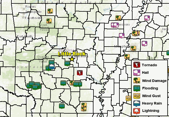
| In the picture: There were several reports of severe weather, heavy rain, and flash flooding on May 9-12, 2023. |
|
| |
|
There was spotty severe weather on the 10th/11th. On the 10th, a weak tornado (rated EFU, where "U" is unknown because no damage was found) briefly touched down in an open field several miles northeast of Warbritton (Jefferson County). Strong to damaging winds downed trees and/or power lines near Gum Springs (Newton County), Harrison (Boone County), and Paragould (Greene County).
|
|
|
| In the pictures: An enormous oak tree fell on a house in Conway (Faulkner County) on 05/11/2023. The photos are courtesy of the City of Conway, Arkansas. |
|
| |
|
On the 11th, a huge 600-year-old oak tree came down and crushed a house at Conway (Faulkner County). Fortunately, nobody was injured. More trees were downed three miles west of Rison (Cleveland County). A weak tornado (rated EF1) uprooted or snapped numerous trees and removed a roof from a house about five miles south of Hamburg (Ashley County).
|
|
|


 Follow us on YouTube