Are you interested in what happened during a recent event? Check out the report below.
Huge Hail on June 11-16, 2023
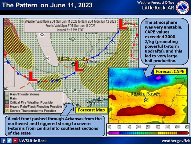
In the picture: A cold front pushed through Arkansas from the northwest and triggered strong to severe thunderstorms from central into southeast sections of the state on 06/11/2023. Very unstable conditions preceded the front, with CAPE (Convective Available Potential Energy/a measure of instability) values over 3,000 Joules/kilogram. CAPE is directly related to updraft strength, and air parcels ascended rapidly to make clouds/storms. Hailstones were also suspended aloft, which allowed the stones to grow and become very large (to the size of golf balls to baseballs). Forecast CAPE information is courtesy of the College of DuPage.
After a stagnant pattern and a lack of rain during the latter half of May, storm systems started moving again to begin June. On the 11th, a cold front arrived from the northwest, and encountered a very warm/unstable environment in Arkansas.
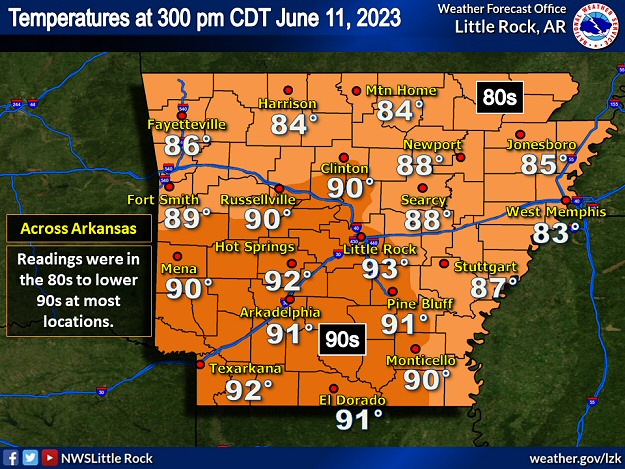
In the pictures: The most unstable air was over central and southern Arkansas at 300 pm CDT on 06/11/2023. This is where temperatures were mostly in the upper 80s to lower 90s, and dewpoints were in the upper 60s to lower 70s.
By 300 pm CDT, temperatures were in the 80s to lower 90s. The thermometer showed 93 degrees at Little Rock (Pulaski County), 92 degrees at Hot Springs (Garland County) and Texarkana (Miller County), and 91 degrees at Arkadelphia (Clark County), El Dorado (Union County), and Pine Bluff (Jefferson County). Dewpoints were in the upper 60s to lower 70s across central and southern sections of the state (indicating abundant low level moisture).
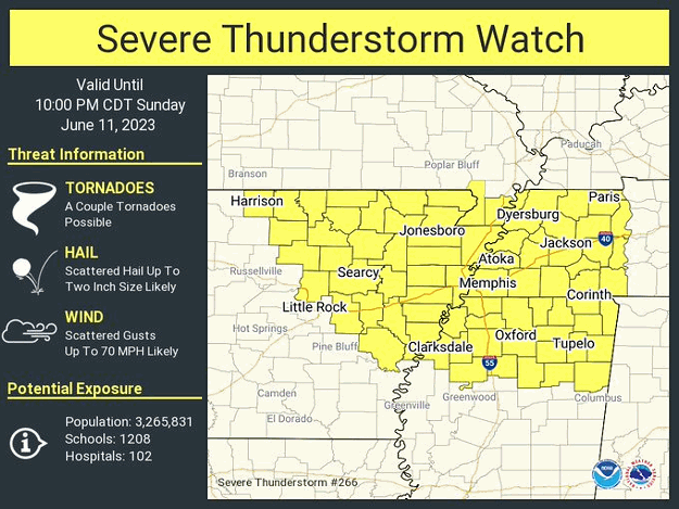
In the picture: A Severe Thunderstorm Watch was posted across much of northern, central, and eastern Arkansas during the late afternoon and evening of 06/11/2023.
Any thunderstorms that developed (triggered by the incoming front) had plenty of fuel to thrive and potentially become severe. The main concerns during this event were very large hail and strong to damaging wind gusts.
Here is a look back at our severe weather event on Sunday via radar (from 430 pm to 800 pm CDT). Most strong/severe storms affected central into east central and southeast Arkansas. Up to baseball size hail was reported at Clarendon (Monroe Co).#arwxpic.twitter.com/ghrv5yVvln
In the video: The WSR-88D (Doppler Weather Radar) showed scattered strong to severe thunderstorms affecting mainly central, east central, and southeast Arkansas from 430 pm to 800 pm CDT on 06/11/2023.
Scattered severe thunderstorms erupted during the late afternoon and into the evening (mostly between 430 pm and 800 pm CDT). Storms tended to develop along and south of Interstate 40 from Morrilton (Conway County) to West Memphis (Crittenden County), and north/east of Highway 65 from Little Rock (Pulaski County) to Dumas (Desha County).
What happens when you have lots of instability? Cloud go BOOM!
In this timelapse looking SE from near Cabot, you see rapid convective development evidenced by cumulus towers that "explode" skyward. Once mature, this storm produced baseball size hail near Clarendon. #arwxpic.twitter.com/OaPh4k48T6
In the video: A storm rapidly developed and went on to produce baseball size hail at Clarendon (Monroe County) on 06/11/2023. The storm was viewed from Cabot (Lonoke County) looking to the southeast.
One of the biggest storms of the day unleashed baseball size hail at Clarendon (Monroe County) around 514 pm CDT. Golf ball size hail was reported at Blackton (Monroe County), Pendleton (Desha County), a few miles northwest of Plumerville (Conway County), and Roe (Monroe County).
There was ping pong ball size hail at Marked Tree (Poinsett County), and half dollar size hail at Helena-West Helena (Phillips County), just southeast of Morrilton (Conway County), and a couple of miles southwest of Springhill (Faulkner County). Northwest of Colt (Cross County), a roof was removed from a home, and several semi trucks were overturned.
By the 12th, the front exited the state to the south and stalled along the Gulf Coast. Drier air/lower dewpoints were noted locally, and rumbles of thunder took a break. The next day, there were some hail producing storms in southwest Arkansas north of the front. Winthrop (Little River County) had baseball size hail. It was the same story five miles northwest of Ben Lomond (Sevier County). Hail to the size of tennis balls was noted near Roy (Pike County), with pool ball size hail at Dierks (Howard County), and hen egg stones at Nashville (Howard County).
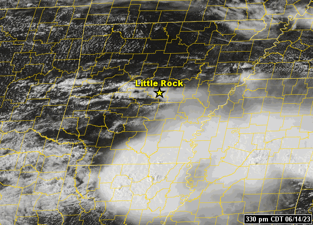
In the pictures: The satellite showed a large area of showers and thunderstorms exiting northern Louisiana, with a new batch of strong to severe thunderstorms erupting across the central third of Arkansas during the afternoon/early evening of 06/14/2023.
The most prolific day for hail was the 14th. Boy, was there a lot of hail! There were around two dozen reports of two inch diameter hail (hen egg size) or larger, which was pretty close to what occurred on April 2, 2006. On that historic day more than seventeen years ago, up to five inch diameter hail (tied for the state record) pummeled the landscape two miles north of Searcy (White County). As far as June goes, the event on the 30th of 2009 comes to mind. On that day, hail to baseball size caused a lot of destruction from North Little Rock and Sherwood (both in Pulaski County) to Lonoke (Lonoke County).
The fireworks started early, with a swath of golf ball to hen egg size hail in the morning from Winslow (Washington County) to Vilonia (Faulkner County) and Cabot (Lonoke County).
How Rare is Huge Hail?
With the exception of 2005 and 2013, baseball size or larger hail was observed in Arkansas at least once a year since 1980 (through 2022). Hail at least softball size occurred once every other year (22 of 43 years). As far as numbers of reports, of the roughly 6,063 instances of quarter size or larger hail, 2,537 were at least golf balls (41.8% of reports), 269 were at least baseballs (4.4% of reports), and 54 were at least softballs (0.9% of reports). The largest hailstones were five inches in diameter (slightly larger than a DVD) on January 21, 1999; April 2, 2006; and May 4, 2020.
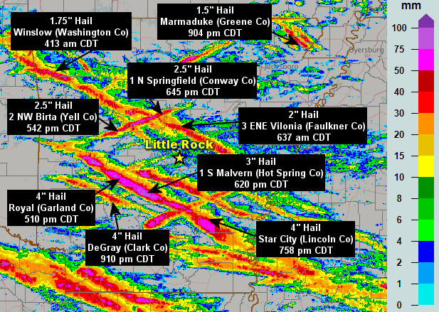
In the picture: Swaths of large hail revealed the paths of severe storms (mostly from northwest to southeast) on 06/14/2023. Hail was up to two inches in diameter during the morning, and up to softball size (four inches in diameter) in the afternoon/evening.
The afternoon/early evening of the 14th was unbelievable. One storm in particular deposited up to softball size hail from northeast of Sims (Montgomery County) to the Hot Springs (Garland County) area, Malvern (Hot Spring County), and Star City (Lincoln County). Another storm unloaded softball size stones near DeGray (Clark County), with a third storm chunking out tennis balls northwest of Birta (Yell County) and just north of Springfield (Conway County).
Baseball Size Hail or Larger (June 14, 2023)
Location
Hail Size (Inches)
2 NW Crystal Springs (Garland County)
4.00
DeGray (Clark County)
4.00
Royal (Garland County)
4.00
2 NNE Sims (Montgomery County)
4.00
3 WNW Slabtown (Grant County)
4.00
Star City (Lincoln County)
4.00
2 NE Lake Hamilton (Garland County)
3.00
1 S Malvern (Hot Spring County)
3.00
3 SSW Abco (Hot Spring County)
2.75
Pearcy (Garland County)
2.75
2 NW Royal (Garland County)
2.75
Note: Miles and directions from locations are shown, such as "2 NW" (two miles northwest) or "3 SSW" (three miles south-southwest).
In the video: Hail up to softball size pelted the south side of Hot Springs (Garland Co) on 06/14/2023, including areas around Lake Hamilton. The video is courtesy of Lou Petitford.
The hail tore up roofs, gutters, and siding, and dented vehicles and boats. Damage was extensive, and there is no doubt that the cost will run in the tens of millions of dollars.
In addition to the hail, thunderstorm wind gusts topped out at 59 mph near El Dorado (Union County), and 53 mph just northwest of Lake Village (Chicot County).
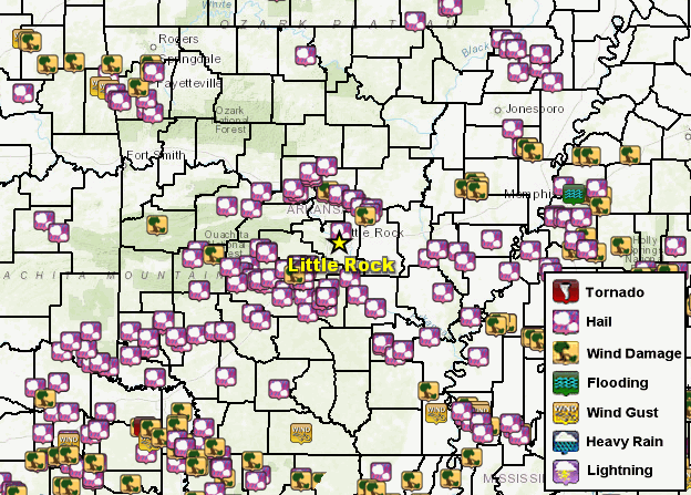
In the picture: There were numerous reports of severe weather (mainly large hail) across Arkansas on June 11-16, 2023.
There was another lull on the 15th, but hail returned on the 16th (associated with the aforementioned Gulf Coast stationary front). Baseball size hail dropped from the sky at Hot Springs Village (Garland County), east of Traskwood (Saline County), and Sheridan (Grant County). Golf ball size hail hit Jessieville (Garland County). A tree was blown down on the north side of Glen Rose (Hot Spring County).
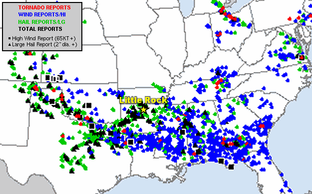
In the picture: From the Rockies eastward, there were hundreds of reports of severe weather on June 11-16, 2023. The graphic is courtesy of the Storm Prediction Center.
Significant severe weather was not confined to Arkansas on the 11th through the 16th. From eastern Colorado and west Texas to parts of the mid-South, large hail and isolated tornadoes were the main features (along with damaging wind in places). Across the southeast states, there was more wind and less hail, along with tornadoes here and there. The strongest tornado (rated EF3) was at Perryton, TX on the 15th. The tornado damaged or destroyed homes, retail stores, and industrial buildings, and was responsible for three fatalities. Other significant tornadoes (rated EF2) were spawned (on the 14th/15th) in the Texas panhandle, eastern Texas, southern Oklahoma, northern Ohio, and southwest Georgia.


 Follow us on YouTube