 |
| About This Page |
| Arkansas has had its share of historic events, many of which will be in our memories for years to come. |
|
|
 |
The F5 Tornado of April 10, 1929 |
 |
| |
| Late on the afternoon of April 10th 1929, a tornado ranked as F5 (the maximum intensity on the Fujita scale of tornado intensity) struck northern Jackson County. This is the only F5 tornado ever documented in Arkansas. It has come to be known as the "Sneed Tornado". The death toll was listed as 23, with at least another 59 people injured. Some of the injuries were quite severe, including skull fractures. |
| A number of other tornadoes struck the northeast quarter of Arkansas that day, and separating one damage path from another was difficult since storm surveys were not done in those days by the U.S. Weather Bureau. |
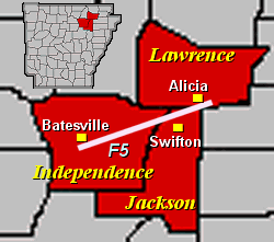 |
However, it is believed that the tornado began in Independence County about 3 miles south of Batesville. The tornado then crossed into Jackson County in the Black River bottoms, likely in the area north of Centerville. |
| In the picture: The only documented F5 tornado in Arkansas tracked through northeast sections of the state on April 10, 1929. The tornado killed 23 people. |
| The tornado reached its maximum intensity in Jackson County around Pleasant Valley, also known locally as Possum Trot, and then on through the community of Sneed. Both of these communities, located about 2 1/2 to 3 miles north of Swifton, were virtually destroyed. Historical accounts, as well as the report of an eyewitness who is still alive today, indicated that the tornado was 1/2 mile wide at this point. The tornado then began to weaken and passed on just to the south and east of Alicia (Lawrence County). |
| Pleasant Valley was located on what is now Jackson County Road 72, also known as Ollie Smith Road. Sneed was located on what is now Jackson County Road 630, also known as Sneed Road or Tavern Road. |
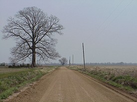 |
| In the picture: The Pleasant Valley community used to be located along what is now Jackson County Road 72. The Pleasant Valley School was located near the tree to the left of the road, with the school destroyed by the F5 tornado on April 10, 1929. |
 |
A Red Cross survey completed several days after the tornado indicated 75 families, including a total of 450 people, were affected by the tornado. Forty homes were destroyed and another 40 were damaged. Thirty-six barns were destroyed. In addition, a number of farm animals were killed. |
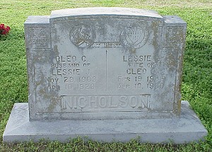
| In the picture: Victims of the F5 tornado on April 10, 1929 included Mr. Cleo Nicholson, a beloved teacher at the Pleasant Valley School, and his wife Lessie. Accounts stress that Mr. Nicholson's students were moved to tears when they heard of his passing. |
|
Some of the historical accounts included...
1 - The devastating storm made a clean sweep of the area.
2 - Homes were left in splinters...very little salvage was left.
3 - The twister went through timber places as though nothing was in the way, tearing up or breaking off huge trees and laying everything flat that happened to be in its path.
4 - Only the pillars of one house remained. The ground was swept clean. A woman and her daughter had hurried to a nearby home for protection, and were entering it when the storm caught the dwelling and carried it with its occupants through the air for 75 yards...before dropping them in a drainage ditch.
5 - The home of one man in Sneed was reduced to kindling.
6 - At the home of another family, the mother, father, and seven children were at home. When the tornado struck, the family members were scattered for 200 yards. Fatalities included the father, and three of the children (ages 6 years, 22 months and 11 months). All the other family members were injured.
7 - The Pleasant Valley School, also known as the Possum Trot School, was destroyed.
8 - The engineer of a Missouri Pacific passenger train spotted the tornado as the train was traveling from Little Rock (Pulaski County) to Hoxie (Lawrence County). The engineer sped the train up and outran the tornado, but not before the train reached speeds up to 75 mph. /This is not meant to imply that the tornado itself was traveling that fast. Rather, it was approaching at an angle to the railroad tracks and the engineer was trying to judge how fast he would have to go to remain ahead of the tornado./
9 - Rescue efforts were hindered by roads made very muddy by heavy rain after the tornado passed, and by large timbers and other debris blocking roads.
10 - Very little tornado insurance was carried by owners of property.
|
| A large number of people saw the tornado coming and took shelter in various places. There were several storm cellars in the area, and many people headed for these. According to one account, about 25 people gathered in one cellar alone. One of the storm cellars still exists today (as of 2003), although in a deteriorated condition. Others sought shelter under a road bridge, in a barn, and in a chicken house. |
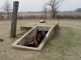 |
| In the picture: Several storm cellars, including this one (located about a quarter mile north of Jackson County Road 630 near where Sneed used to be), were used to hide from the F5 tornado on April 10, 1929. |
|
One survivor of the storm, who was a boy at the time, spotted the tornado and warned his mother. In his account of that day, the man noted that he remembered from science and geography books how a tornado looked.
Pictures taken after the storm bear out the destruction that occurred. Some of the photos show debris scattered around so badly that it was impossible to determine exactly what type of structure had been destroyed.
The Fujita Scale of tornado intensities was devised by T. Theodore Fujita in the early 1970s. As part of a research project for the Nuclear Regulatory Commission, Fujita studied and ranked tornadoes from the past. Thomas Grazulis later followed up on the work of Fujita and restudied the events. These studies are the basis for the ranking of the Sneed Tornado as an F5. According to the scale, F5 tornadoes would have winds of 261-318 mph.
Other tornadoes that struck on April 10th, 1929 included an F4 tornado that struck Guion (Izard County) and another F4 tornado that traveled from 4 miles southwest of Wynne through Smiths Chapel and Princedale to north of Parkin (all in Cross County).
Sources used for information on the Sneed Tornado included interviews with area residents, as well as...
| Monthly Weather Review from April, 1929 |
| Swifton Centennial |
| Significant Tornadoes 1680-1991 by Thomas P. Grazulis |
| U.S. Tornadoes by T. Theodore Fujita |
| Newport Daily Independent |
| Newport Weekly Independent |
| The Tuckerman Record |
| Arkansas Gazette |
| Arkansas Democrat |
|
|
|


 Follow us on YouTube