
Tropical system in the Gulf expected to gradually strengthen the next couple of days off the Florida Panhandle and Alabama coasts. Instances of flash flooding will be possible through Thursday along the eastern and central Gulf Coast. Severe thunderstorms will develop and move along a cold front crossing the Upper Midwest, and through the Ohio Valley/Mid-Atlantic on Tuesday. Read More >
"Chicago Flood
and Wisconsin Tornadoes"
17-19 July 1996
Derived Product Imagery contributed by Gary Wade (SSEC)
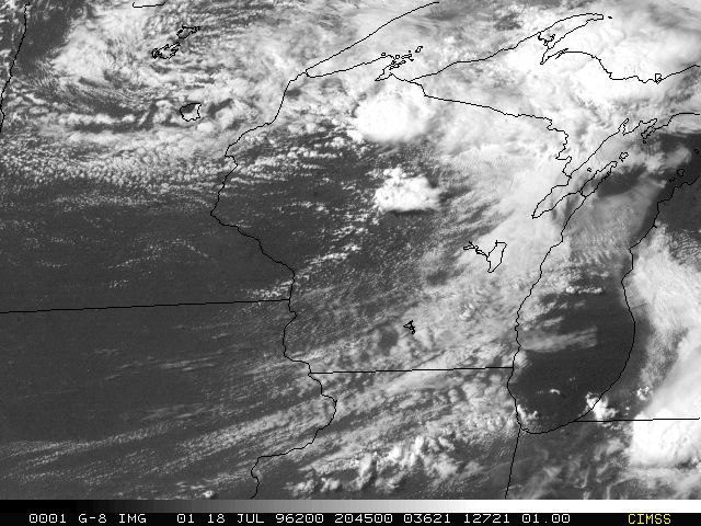
GOES-8 Imager 1-km res visible image at 2045 UTC on 18 July 1996. Isolated but strong convective storms are evident in central and north central WI; small convective cells mark the cold front extending from the central WI storm to extreme southeastern MN.
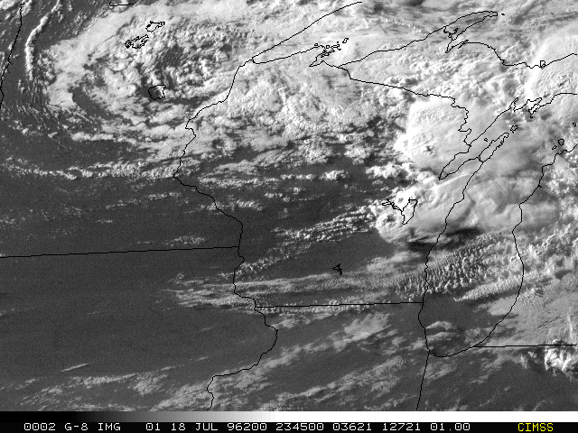
As above but at 2345 UTC. The storms have continued to develop and have moved into eastern WI. A very strong tornado (briefly reaching F5 intensity) occurred at Oakfield (WI), which is 15 km SSW of the southern tip of Lake Winnebago, about 0015 UTC (shortly after this image). Note that the large thunderstorm at 2045 UTC in central WI had moved to northern Lake Winnebago at 2345 UTC. The Oakfield storm developed and moved along to the south of that first storm.
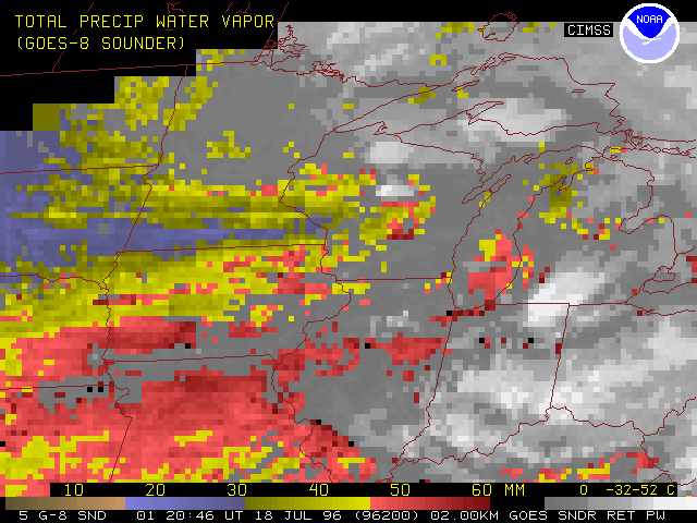
GOES-8 Sounder 10-km Derived Product Image (DPI) of total precipitable water vapor (PW) at 2045 UTC on 18 July 1996. Moist to dry air masses are indicated by color coding (red to yellow to blue to beige), while clouds remain in shades of gray, as indicated by the scale at the bottom. Note high moisture values (50+ mm) extending from NE/KS across to IN/southern MI, while dry air (<30 mm) from the Dakotas works into extreme west central WI. In particular, note localized regions of very high PW (55+ mm) in central WI.
As above but at 2345 UTC. Note that the eastern WI storms remain on the moisture gradient, as the cold front moved across WI. Radiosonde PW values at 00 UTC show reasonable agreement with the GOES Sounder DPI. Note how moisture patterns (including moist and dry axes)are very evident in the relatively high horizontal DPI (versus the isolated upper air database).
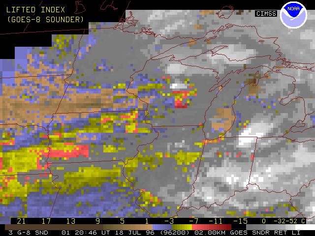
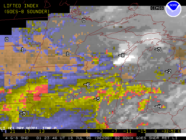
GOES-8 Sounder 10-km DPI of lifted index (LI) at 2045 UTC on 18 July 1996. Atmospheric stability in clear air is indicated by color coding, with brown/beige being very stable through red being most unstable, again with clouds in gray. Besides the generally unstable air on the warm side of the synoptic scale front running from NE to WI, note the local pockets of high instability (-8 to -10 C) in central WI. Also, note rather stable air (+2 C) entering west central WI.
As above but at 2345 UTC. Note general agreement of the LI DPI with the 00 UTC radiosondes.
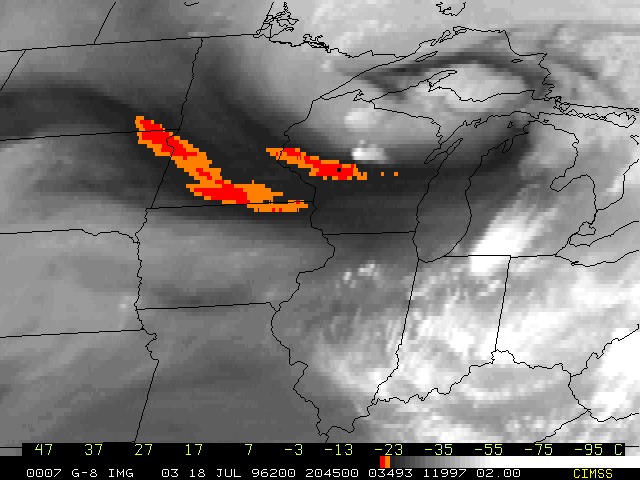
GOES-8 Imager 8-km res upper level water vapor image (6.7 um) at 2045 UTC on 18 July 1996. The red-orange dry slots show subsidence associated with a strong 50-70 kt northwesterly jet max that ran from southern MN across WI to western MI.
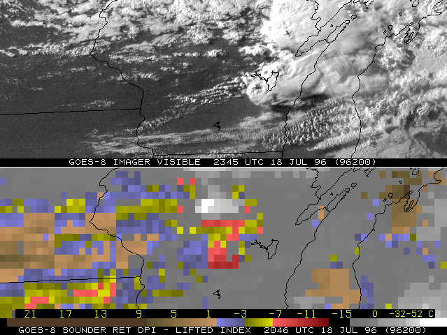
Two panel display with the 2345 UTC GOES-8 Imager visible image over central WI on the top, with the (antecedent) 2045 UTC GOES-8 Sounder lifted index (stability) DPI on the bottom. The Oakfield tornado occurred about 0015 UTC on 19 July 1996 just south of Lake Winnebago in eastern WI.

