Above Average Spring Flood Risk - issued Feb 12, 2021
Key Points
- Above average risk for flooding across most of southern Wisconsin, except for the Sheboygan and Wisconsin River basins where risk is average
- Additional snowpack will increase the flood risk
- The amount of flooding largely depends on heavy rain and rate of snow melt
- River flooding in Wisconsin typically occurs in March and April when there is a rapid snowmelt and/or heavy rain. But, it can happen any time of year when there is heavy rain.
- Above average risk of flooding and backwater effects of river mouths near Lake Michigan due to high lake levels
- Ice jam risk is low to medium
|
Spring Flood Risk Factors:
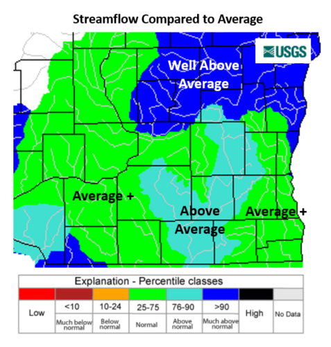
- High river levels - Yes
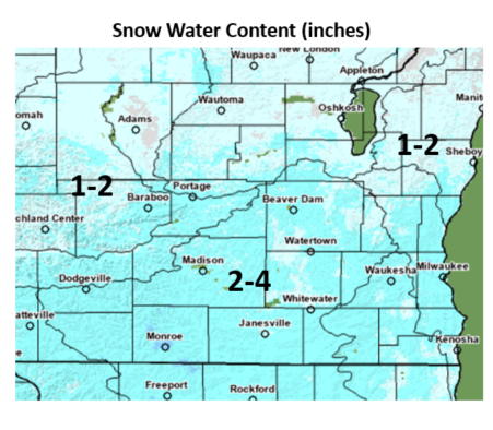
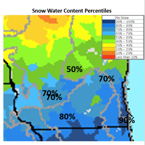
- Deep Snowpack - Yes
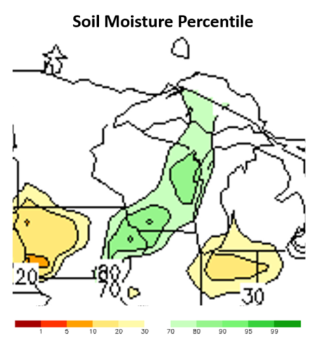
- High soil moisture - somewhat
- Deep frost depth - Not a factor this year
- Rapid Snow Melt - Unknown
- Heavy rain - Unknown
|
Why?
- Rivers are still running high from abnormally high rain in the past few years. Higher than normal flows in rivers are likely into spring. This means less room in rivers for additional rain and melting snow, increasing the flood risk.
- The water contained in the snowpack is above average. Most of this snow will make its way into rivers when it melts, increasing the flood risk.
- Soil moisture is somewhat elevated. There is some room in the soil to absorb moisture, but it could be better. Frost depth is 3-10 inches, which is pretty shallow. A shallow frost will thaw sooner and allow the ground to soak up moisture, helping to limit flooding. But, there is a lot of water to absorb with the deep snow pack.
Forecast/Outlook
River flooding and inundation of river mouths near Lake Michigan, due to the high Lake Michigan water levels, is expected to continue into the summer.
Extended outlooks from the Climate Prediction Center. High temperatures above freezing and lows below freezing promote a slow snow melt, but a heavy rain or big warm up could cause a rapid snow melt and flood potential.
Flood Risk Factors as of 2/12/2021
| |
Preparedness/Early Actions:
- Get a NOAA Weather Radio to be alerted to flash flood warnings and river flood warnings
- Monitor weather forecasts for heavy rain potential
- Have a communications plan for your family and a place to meet in higher ground.
- Monitor river levels and forecasted river levels online: (National Site, USGS, MKX)
- Know a safe way to exit your home and neighborhood, including any roads susceptible to flooding
- Prepare your home:
- Consider flood insurance, especially if you are in a flood prone area - (may require 30 day notice)
- Make sure your sump pump is working and consider a backup.
- Have a professional install check-values to prevent floodwaters from backing up into the drains of your home
- Keep important documents in a waterproof, elevated container, not in the basement.
- Remove snow from roof, downspout area, and away from base of home
- Finish any outdoor projects that may be affected by heavy rain or flood waters
- Prepare (Flood Ready, Flood Safety)
How To Stay Safe During a Flood:
- Heed evacuation orders and evacuate your home if it is at risk
- Turn Around, Don't Drown - never drive through flooded roads
- You do not know how deep the water is or if the road has been washed out
- You may damage your vehicle
- You put yourself and first responders at risk
|
Additional Information:
Long range probabilistic river forecast information: Probability Graphs
Text probabilistic river forecast information: Flood Potential Outlook
Feb. 12, 2021 Webinar Recording
This outlook will be updated around February 25.
If you have any questions or comments about this spring flood outlook please contact:
Sarah Marquardt
Senior Service Hydrologist
National Weather Service Milwaukee
sarah.marquardt@noaa.gov