
Tropical Depression Two is expected to gradually strengthen and could bring tropical storm conditions to the Florida Panhandle beginning late Monday. Areas of flash flooding will be possible through Thursday along the eastern and central Gulf Coast. Severe thunderstorms will develop and move along a cold front crossing the Upper Midwest Monday, and through the Ohio Valley/Mid-Atlantic on Tuesday. Read More >
Overview
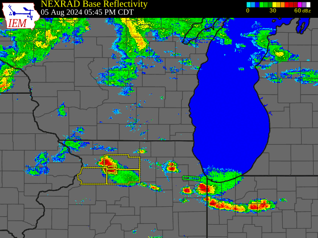
Scattered thunderstorms moved across southern Wisconsin during the evening and overnight hours of August 5-6. Said storms were primarily rainfall producers in most locations, though they did become severe on a localized basis. One tornado warning would be issued for portions of Green and Rock Counties during the evening hours on August 5, in addition to a pair of severe thunderstorm warnings during the predawn hours on August 6. No confirmed tornadoes occurred in the NWS Milwaukee/Sullivan county warning area, though a handful of damaging wind reports were relayed from Dane and Walworth Counties. This news article briefly recaps the August 5-6 event, taking a closer look at radar imagery and storm reports, as well as the meteorology driving it.Radar
 |
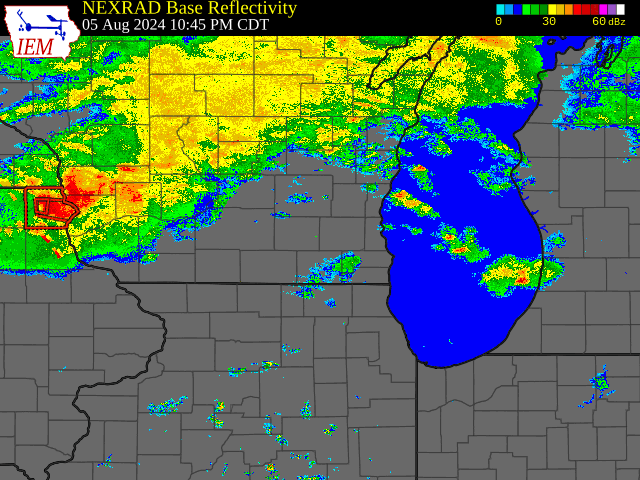 |
| Radar imagery and warnings between 5:45 PM and 9:00 PM CDT August 5. Radar data obtained from IEM Cow. Click on the animation to enlarge. | Radar imagery and warnings between 11:45 PM CDT August 5 and 2:50 AM CDT August 6. Radar data obtained from IEM Cow. Click on animation to enlarge. |
Storm Reports
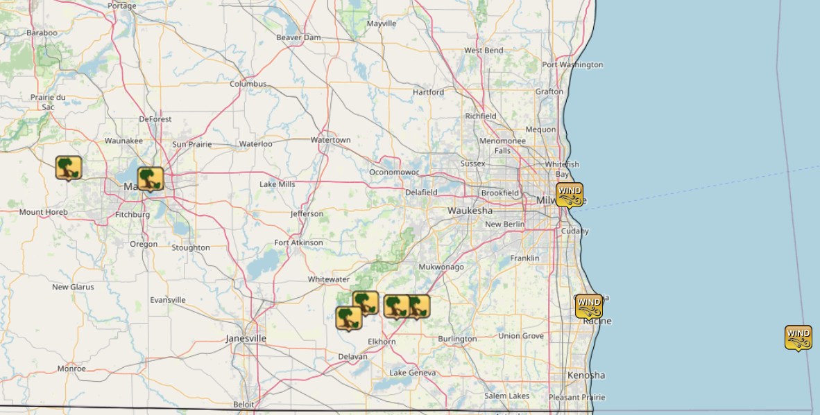 |
| Image of storm reports from the late evening of August 5 and predawn hours of August 6. Image obtained from the IEM Cow storm reports archive. Click on image to enlarge. |
Environment
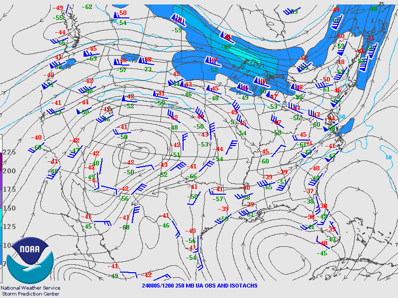
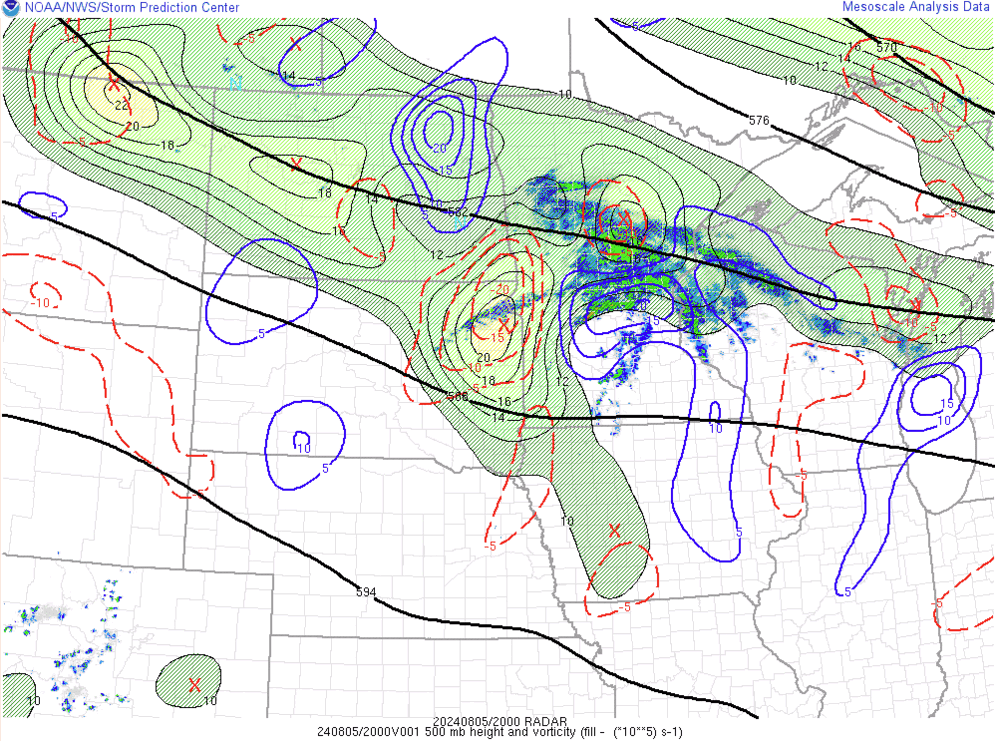
A west-northwesterly mid to upper level flow pattern was entrenched across the Upper Midwest between August 5 and 6. In the upper portions of the atmosphere, high pressure was centered over the Colorado-New Mexico border. A 100-125 knot upper jet streak swung around the northeastern side of the aforementioned high, crossing the western Great Lakes from the afternoon of August 5 through the predawn hours of August 6 (figure 1). In the middle portions of the atmosphere, several shortwave troughs were evident over the Northern Plains and western Great Lakes during the August 5-6 timeframe. Lift affiliated with one of these disturbances helped to trigger showers and storms along the Minnesota-Iowa border on the afternoon of August 5 (figure 2). Said activity would ultimately track into southern Wisconsin during the predawn hours on August 6, and would be responsible for the damaging wind reports received from Dane and Jefferson Counties.
At the surface, low pressure tracked from the Missouri Valley to northern Illinois from August 5 through sunrise on August 6 (figure 3). An initially stationary surface front ran through the surface low, becoming progressive during the afternoon of August 5. The Iowa-Illinois portion of the boundary returned north as a warm front in the process, approaching the Wisconsin-Illinois border by the early evening hours on August 5. Lift along and north of the warm front aided the development of scattered thunderstorms over far southern Wisconsin during the evening of August 5, one of which would prompt a tornado warning for portions of Green and Rock Counties.
 |
 |
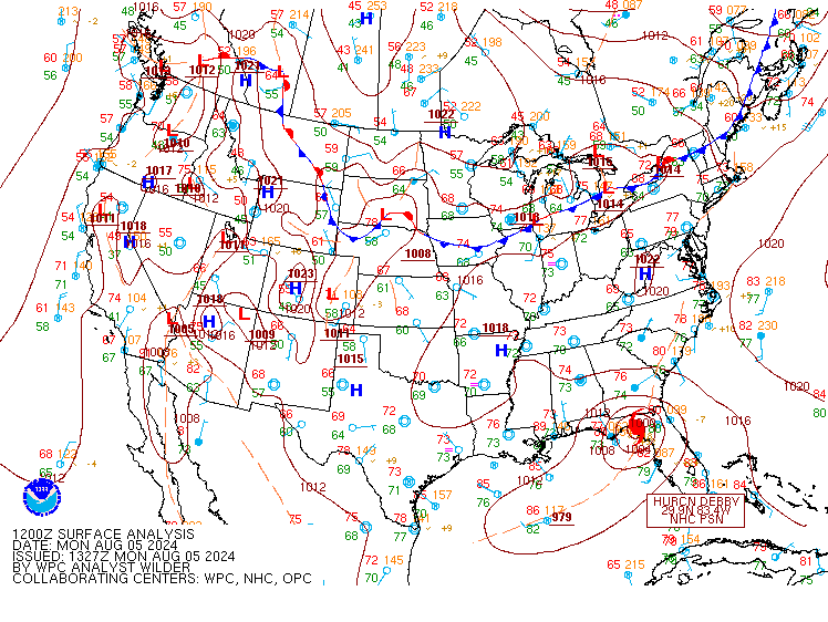 |
| Figure 1: Animation of 250 millibar winds (color shading) and wind directions (indicated in black streamlines) at 7 AM CDT August 5 and 7 AM August 6. Maps obtained from the Storm Prediction Center upper air archive. Click on animation to enlarge. | Figure 2: Animation of 500 mb heights (black lines), vorticity (shading), and 700-400 millibar average vorticity advection (blue and red lines) at 3 PM, 4 PM, 5PM, 6 PM, and 7 PM CDT August 5 respectively. Areas of positive 700-400 mb mean vorticity advection indicate areas favorable for upward motions in the atmosphere. Images obtained from the Storm Prediction Center mesoanalysis archive. Click on animation to enlarge. | Figure 3: Surface charts at 7 AM, 10 AM, 1 PM, 4 PM, 7 PM, and 10 PM CDT August 5, as well as 1 AM and 4 AM CDT August 6. Surface maps obtained from the Weather Prediction Center surface analysis archive. Click on animation to enlarge. |
Thanks to the jet streak in place in the upper portions of the atmosphere, an abundance of wind shear was in place across the area on August 5-6. Analysis from the Storm Prediction Center indicated anywhere between 30-55+ knots of effective shear over southern Wisconsin during this timeframe (figure 4). Said values were more than favorable for organized thunderstorms from the afternoon of August 5 through the predawn hours on August 6, pending favorable instability.
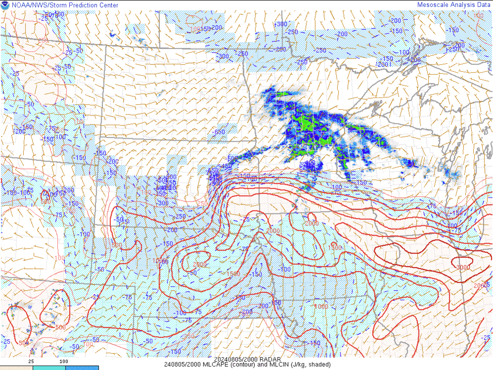
With a hot & muggy air mass in place along/south of the advancing warm front, instability built into portions of southwestern and south-central Wisconsin during the afternoon hours of August 5. Anywhere between 1500 and 3000 joules per kilogram of largely uncapped mixed layer CAPE materialized over this portion of the area (figure 5). Due to cool, northeasterly winds blowing off Lake Michigan, the warm front, and thus the aforementioned reservoir of mixed layer CAPE, struggled to advance deeper into south-central and southeastern Wisconsin. This kept any potential for surface-based thunderstorms at bay over the northeastern half of the region during the August 5-6 time period. Nevertheless, sufficient amounts of elevated instability were in place further north and east (figure 6), supporting the potential for thunderstorms rooted above the boundary layer through the predawn hours on August 6.
.gif) |
 |
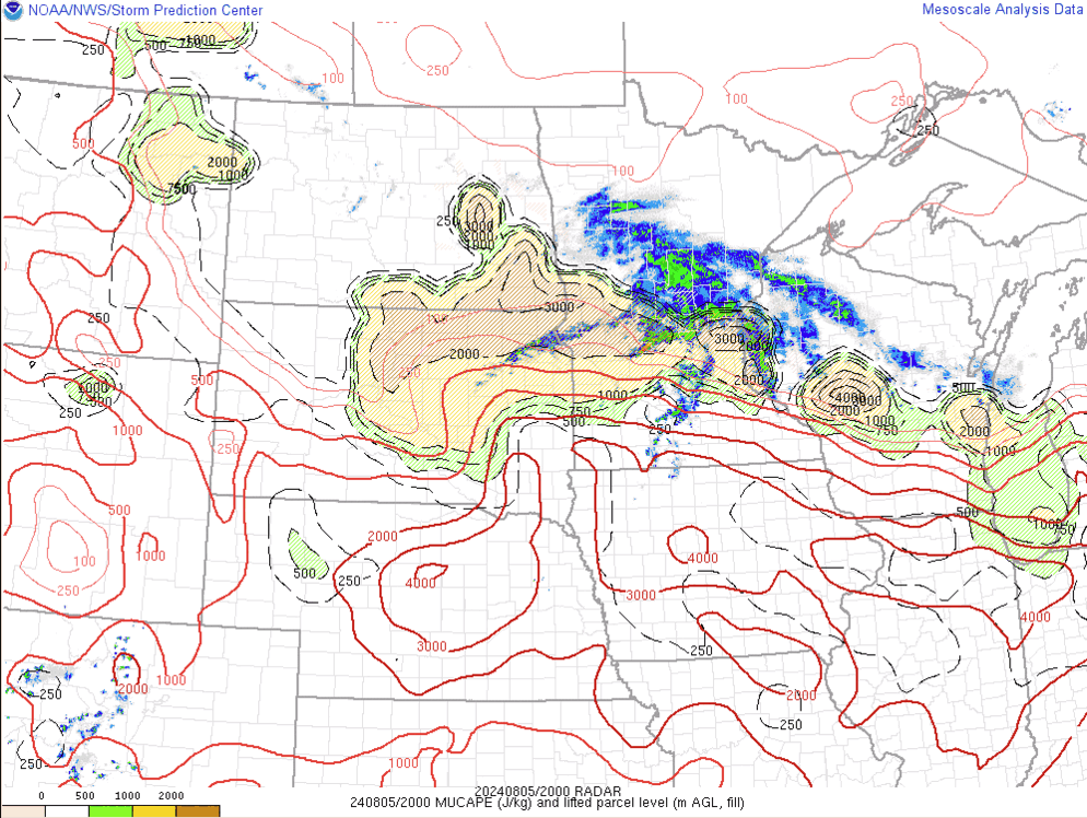 |
| Figure 4: Effective bulk shear magnitudes (blue lines) and vectors (tan wind barbs) at 4 PM, 7 PM and 10 PM August 5, as well as 1 AM and 4 AM August 6. Images obtained from the Storm Prediction Center mesoanalysis archive. Click on animation to enlarge. | Figure 5: Mixed Layer CAPE (red lines) and CIN (blue shading) at 3 PM, 4 PM, 5 PM, 6 PM, and 7 PM August 5. Images obtained from the Storm Prediction Center mesoscale analysis archive. Click on animation to enlarge. | Figure 6: Most unstable CAPE (red lines) and lifted parcel levels (color shading) at 3 PM, 4 PM, 5 PM, 6 PM, and 7 PM August 5. Images obtained from the Storm Prediction Center mesoscale analysis archive. Click on the animation to enlarge. |
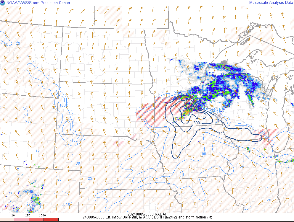
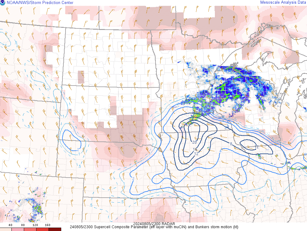
Looking closer at the near-storm environment, a conditionally-favorable setup for supercell thunderstorms was in place in the vicinity of the advancing warm front during the early evening hours on August 5. This potential was fueled by a combination of uncapped instability, in addition to ample amounts of low level wind shear, in the vicinity of the boundary. Analysis from the Storm Prediction Center showed between 200 and 300 meters squared per second squared of effective storm relative helicity over portions of Dane, Green, Iowa, Lafayette, and Rock Counties through the early evening of August 5 (figure 7), confirming the presence of the aforementioned low level wind shear. Supercell composite values thus soared into the 8-12 range over southwestern and far southern Wisconsin (figure 8), verifying that any scattered thunderstorm development would have the potential to rotate and possibly produce a tornado. Said potential would be realized in scattered thunderstorms developing along the Wisconsin-Illinois border, with a tornado warning being issued for portions of Green and Rock Counties at 7:33 PM August 5 (figure 9). The loss of daytime heating, in addition to a linear storm mode, translated to diminished tornado potential in overnight thunderstorms.
 |
 |
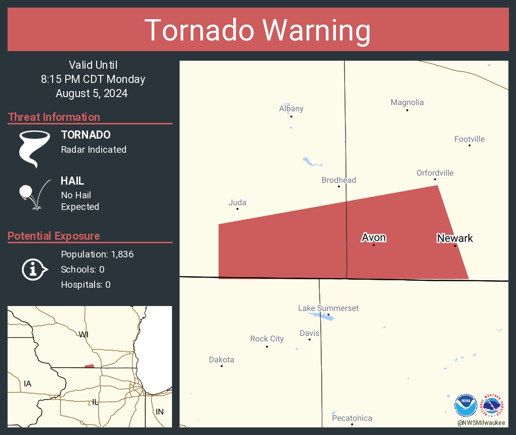 |
| Figure 7: Effective storm-relative helicity (blue lines) and effective inflow layer bases (red shading) at 6 PM, 7 PM, and 8 PM August 5. Images taken from the Storm Prediction Center mesoanalysis archive. Click on animation to enlarge. | Figure 8: Supercell composite parameter (blue lines) at 6 PM, 7 PM, and 8 PM August 5. Images taken from the Storm Prediction Center mesoanalysis archive. Click on animation to enlarge. | Figure 9: Graphic posted to social media following the issuance of the tornado warning for portions of Green and Rock Counties. Click on image to enlarge. |
 |
Media use of NWS Web News Stories is encouraged! Please acknowledge the NWS as the source of any news information accessed from this site. |
|

