June 27th, 2019 Damaging Winds Summary
|
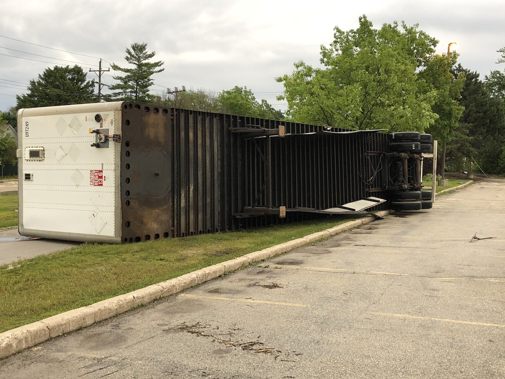
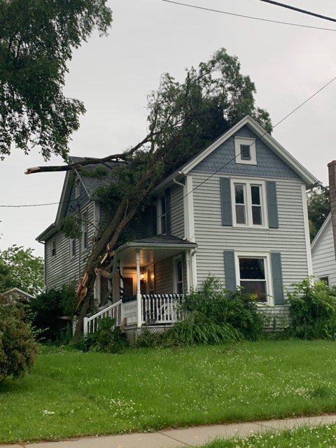
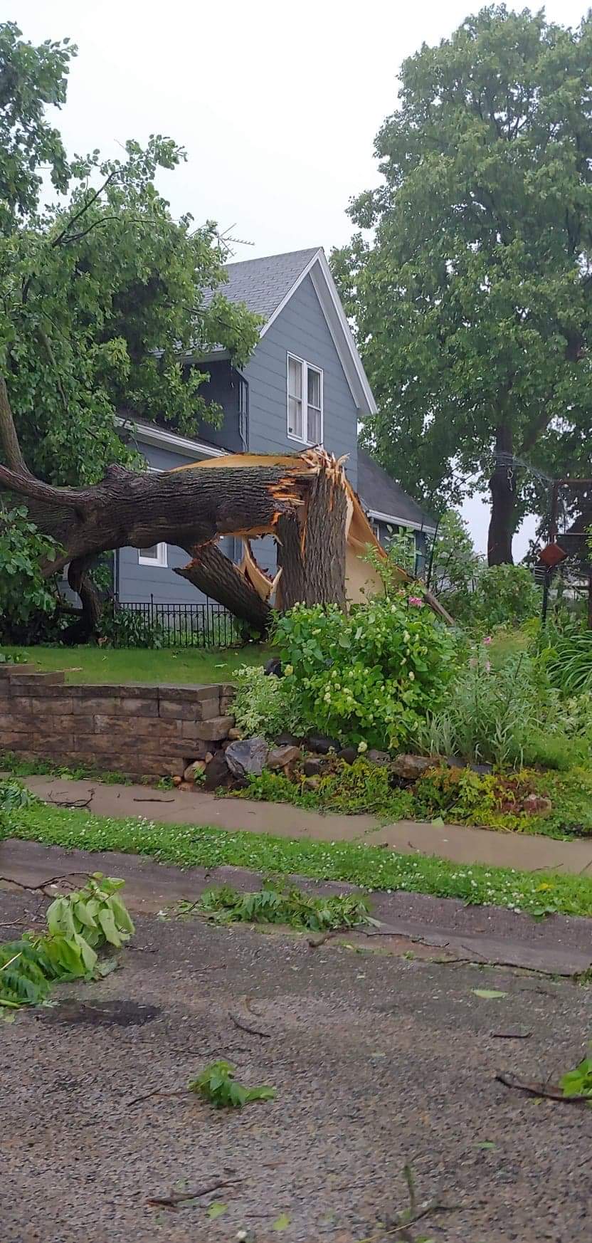
On the morning of June 27th there was a complex of storms over western Minnesota which would shift eastward into southern Wisconsin by midafternoon. During that time the air mass over Wisconsin became more and more unstable which would help fuel the line of thunderstorms as it moved into the area. Around 2:45pm the line moved into western Sauk and Iowa counties bringing with it damaging winds and heavy rain. These storms continued eastward before exiting the lakeshore counties around 7pm. There were 46 reports of strong damaging winds with this line of storms.
Non-severe thunderstorms then continued overnight into Friday morning. |
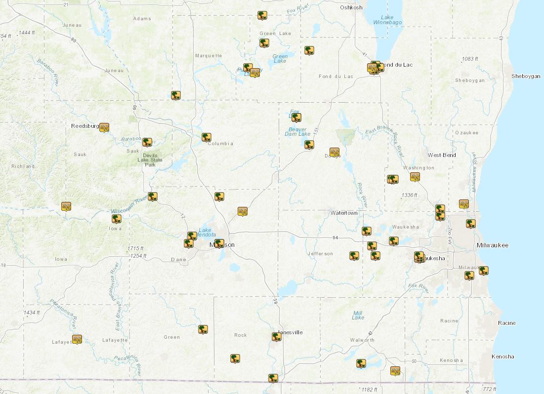
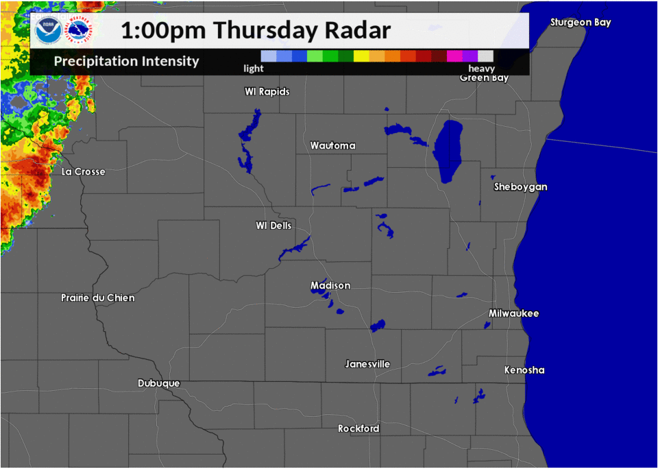 Radar Loop 1-7PM Thursday (click to enlarge) |
Wind:
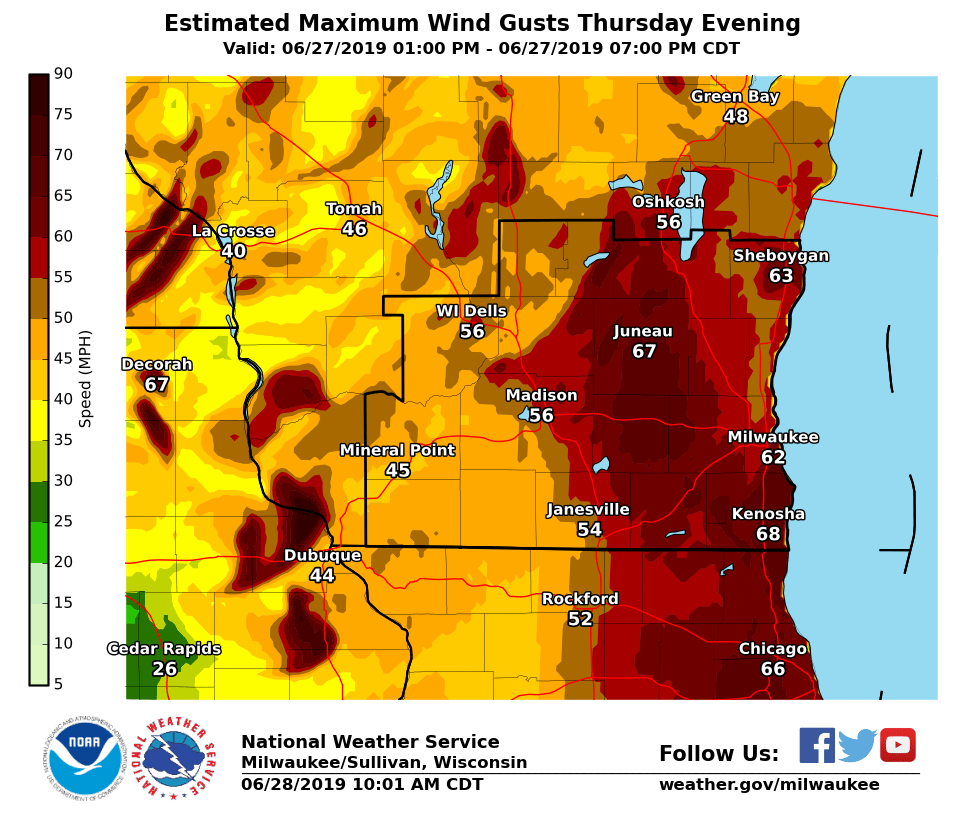
As the line of storms moved through reports of 40 to 63 mph winds were reported, but locally higher gusts were possible.
 |
 |
 |
 |
|
Carroll University, Waukesha Caroline Reinwald |
Deforest, Dane Cassie Heideman |
Fond du Lac, Fond du Lac Justin Buell |
Hartford, Dodge Robb Stephens |
000
NWUS53 KMKX 280333
LSRMKX

PRELIMINARY LOCAL STORM REPORT...SUMMARY
NATIONAL WEATHER SERVICE MILWAUKEE/SULLIVAN WI
1033 PM CDT THU JUN 27 2019

..TIME...   ...EVENT...      ...CITY LOCATION...     ...LAT.LON...
..DATE...   ....MAG....      ..COUNTY LOCATION..ST.. ...SOURCE....
            ..REMARKS..

0556 PM     TSTM WND DMG     3 S GERMANTOWN          43.20N 88.11W
06/27/2019                   WASHINGTON         WI   TRAINED SPOTTER

            LARGE TREE DOWN.

0540 PM     TSTM WND DMG     CUDAHY                  42.95N 87.87W
06/27/2019                   MILWAUKEE          WI   PUBLIC

            LARGE TREE DOWN NEAR MITCHELL AIRPORT.

0533 PM     TSTM WND DMG     3 E GREENDALE           42.93N 87.95W
06/27/2019                   MILWAUKEE          WI   PUBLIC

            LARGE TREES DOWN.

0525 PM     TSTM WND DMG     1 NW GLENDALE           43.14N 87.94W
06/27/2019                   MILWAUKEE          WI   PUBLIC

            LARGE TREE BLOWN OVER.

0523 PM     TSTM WND GST     PELL LAKE               42.54N 88.36W
06/27/2019  E60 MPH          WALWORTH           WI   TRAINED SPOTTER

            TREE DAMAGE IN PELL LAKE.

0520 PM     TSTM WND GST     1 SE MEQUON             43.22N 87.98W
06/27/2019  M58 MPH          OZAUKEE            WI   PUBLIC

            MULTIPLE TREE BRANCHES DOWN.

0512 PM     TSTM WND DMG     2 NNE MENOMONEE FALLS   43.17N 88.11W
06/27/2019                   WAUKESHA           WI   LAW ENFORCEMENT

            TREES AND POWERLINES DOWN ACROSS THE AREA.

0510 PM     TSTM WND DMG     WILLIAMS BAY            42.57N 88.55W
06/27/2019                   WALWORTH           WI   PUBLIC

            FEW LARGE TREES AND POWERLINES DOWN.

0500 PM     TSTM WND GST     2 E SLINGER             43.33N 88.25W
06/27/2019  E60 MPH          WASHINGTON         WI   PUBLIC


0500 PM     TSTM WND DMG     1 ESE WAUKESHA          43.00N 88.22W
06/27/2019                   WAUKESHA           WI   PUBLIC

            STRUCTURAL DAMAGE TO GARAGE.

0455 PM     TSTM WND DMG     1 E DELAFIELD           43.07N 88.37W
06/27/2019                   WAUKESHA           WI   LAW ENFORCEMENT

            SHINGLE DAMAGE.

0450 PM     TSTM WND DMG     1 SE HARTFORD           43.32N 88.38W
06/27/2019                   WASHINGTON         WI   PUBLIC

            LARGE TREE DOWN.

0450 PM     TSTM WND DMG     DOUSMAN                 43.01N 88.47W
06/27/2019                   WAUKESHA           WI   PUBLIC

            TREE UPROOTED.

0447 PM     TSTM WND DMG     1 W OCONOMOWOC          43.11N 88.52W
06/27/2019                   WAUKESHA           WI   NWS EMPLOYEE

            LARGE TREE LIMBS DOWN THROUGHOUT THE
            SOUTHWEST PORTION OF OCONOMOWOC. SOME
            SHINGLES PEELED BACK ON HOUSES.

0445 PM     TSTM WND GST     2 WSW FOND DU LAC       43.77N 88.49W
06/27/2019  M62 MPH          FOND DU LAC        WI   ASOS


0445 PM     TSTM WND DMG     1 S FOND DU LAC         43.77N 88.45W
06/27/2019                   FOND DU LAC        WI   EMERGENCY MNGR

            TREES DOWN IN THE CITY OF FOND DU LAC.

0445 PM     TSTM WND DMG     1 WSW FOND DU LAC       43.78N 88.47W
06/27/2019                   FOND DU LAC        WI   PUBLIC

            LARGE TREES DOWN.

0445 PM     TSTM WND DMG     2 NNW DOUSMAN           43.05N 88.49W
06/27/2019                   WAUKESHA           WI   NWS EMPLOYEE

            8 TREES DOWN, WITH 1-2 DOZEN LARGE LIMBS
            DOWN ALSO.

0440 PM     TSTM WND DMG     2 SW FOND DU LAC        43.76N 88.48W
06/27/2019                   FOND DU LAC        WI   PUBLIC

            BILLBOARD DAMAGE.

0440 PM     TSTM WND DMG     SULLIVAN                43.01N 88.59W
06/27/2019                   JEFFERSON          WI   EMERGENCY MNGR

            NUMEROUS TREES DOWN IN THE EASTERN SIDE OF
            JEFFERSON COUNTY, MORE SO BY SULLIVAN. POWER
            LINES DOWN THERE AS WELL WITH 4,000 PEOPLE
            WITHOUT POWER.

0435 PM     TSTM WND DMG     2 SW BELOIT             42.51N 89.04W
06/27/2019                   ROCK               WI   EMERGENCY MNGR

            TREES DOWN ACROSS THE AREA.

0430 PM     TSTM WND DMG     JANESVILLE              42.68N 89.02W
06/27/2019                   ROCK               WI   LAW ENFORCEMENT

            TREES DOWN ACROSS THE AREA.

0427 PM     TSTM WND GST     2 N JUNEAU              43.43N 88.70W
06/27/2019  M63 MPH          DODGE              WI   AWOS


0425 PM     TSTM WND DMG     BEAVER DAM              43.46N 88.84W
06/27/2019                   DODGE              WI   EMERGENCY MNGR

            POWERLINES AND TREES DOWN.

0420 PM     TSTM WND DMG     ALBANY                  42.71N 89.43W
06/27/2019                   GREEN              WI   LAW ENFORCEMENT

            TREES DOWN ACROSS THE AREA.

0420 PM     TSTM WND DMG     3 S ORFORDVILLE         42.59N 89.25W
06/27/2019                   ROCK               WI   LAW ENFORCEMENT

            TREES DOWN.

0420 PM     TSTM WND DMG     RIPON                   43.84N 88.84W
06/27/2019                   FOND DU LAC        WI   PUBLIC

            LARGE TREES DOWN.

0415 PM     TSTM WND DMG     FOX LAKE                43.57N 88.91W
06/27/2019                   DODGE              WI   EMERGENCY MNGR

            CORRECTS PREVIOUS TSTM WND DMG REPORT FROM
            FOX LAKE. TREES AND POWERLINES DOWN.

0405 PM     TSTM WND DMG     6 E NESHKORO            43.98N 89.10W
06/27/2019                   GREEN LAKE         WI   EMERGENCY MNGR

            TREES DOWN.

0405 PM     TSTM WND DMG     2 ENE PRINCETON         43.87N 89.09W
06/27/2019                   GREEN LAKE         WI   EMERGENCY MNGR

            TREES DOWN.

0405 PM     TSTM WND GST     MARQUETTE               43.75N 89.14W
06/27/2019  M59 MPH          GREEN LAKE         WI   EMERGENCY MNGR


0404 PM     TSTM WND GST     MARQUETTE               43.75N 89.14W
06/27/2019  E55 MPH          GREEN LAKE         WI   FIRE DEPT/RESCUE


0355 PM     TSTM WND GST     1 E SUN PRAIRIE         43.19N 89.21W
06/27/2019  E60 MPH          DANE               WI   PUBLIC


0350 PM     TSTM WND DMG     MONONA                  43.06N 89.34W
06/27/2019                   DANE               WI   PUBLIC

            LARGE OAK TREE DOWN IN MONONA, WINNEQUAH AND
            MAYWOOD STREETS. POWER LINES AFFECTED. LARGE
            LIMBS DOWN NEARBY ALSO.

0350 PM     TSTM WND DMG     3 NW MARQUETTE          43.77N 89.18W
06/27/2019                   MARQUETTE          WI   PUBLIC

            TREES DOWN AND EXTENSIVE PIER DAMAGE ON LAKE
            PUCKAWAY.

0345 PM     TSTM WND DMG     DE FOREST               43.25N 89.34W
06/27/2019                   DANE               WI   PUBLIC

            PICTURES OF LARGE BRANCHES DOWN.

0340 PM     TSTM WND DMG     7 SW ENDEAVOR           43.66N 89.58W
06/27/2019                   MARQUETTE          WI   FIRE DEPT/RESCUE

            TREES DOWN NEAR BRIGGSVILLE.

0340 PM     TSTM WND DMG     3 S MIDDLETON           43.06N 89.51W
06/27/2019                   DANE               WI   PUBLIC

            SEVERAL LARGE TREES DOWN IN MIDDLETON AND
            WEST MADISON.

0340 PM     TSTM WND DMG     1 SE MIDDLETON          43.09N 89.49W
06/27/2019                   DANE               WI   PUBLIC

            TOP HALF OF MATURE MAPLE SNAPPED OFF ONTO
            GARAGE ON UNIVERSITY AVE IN MIDDLETON. MANY
            BRANCHES DOWN ALSO.

0340 PM     TSTM WND DMG     5 SE PORTAGE            43.49N 89.41W
06/27/2019                   COLUMBIA           WI   EMERGENCY MNGR

            NUMEROUS TREE LIMBS DOWN SOUTH OF PORTAGE
            NEAR HWY 16 AND 51.

0330 PM     TSTM WND DMG     2 SSE SAUK CITY         43.25N 89.71W
06/27/2019                   DANE               WI   PUBLIC

            SWATH OF TREES DOWN.

0322 PM     TSTM WND GST     1 SSW DARLINGTON        42.67N 90.13W
06/27/2019  E45 MPH          LAFAYETTE          WI   EMERGENCY MNGR

            A FEW SMALL TREE LIMBS DOWN SOUTH OF
            DARLINGTON.

0319 PM     TSTM WND DMG     BARABOO                 43.47N 89.74W
06/27/2019                   SAUK               WI   EMERGENCY MNGR

            NUMEROUS TREES DOWN AROUND BARABOO WITH SOME
            POWER LINES DOWN AS WELL.

0318 PM     TSTM WND DMG     ARENA                   43.16N 89.91W
06/27/2019                   IOWA               WI   EMERGENCY MNGR

            IOWA COUNTY EMERGENCY MANAGEMENT REPORTS
            LOTS OF TREES DOWN BETWEEN MINERAL POINT AND
            ARENA.

0315 PM     TSTM WND GST     1 SE REEDSBURG          43.53N 89.98W
06/27/2019  M46 MPH          SAUK               WI   AWOS

            REEDSBURG AIRPORT.

0256 PM     TSTM WND GST     6 WNW SPRING GREEN      43.21N 90.19W
06/27/2019  M55 MPH          SAUK               WI   ASOS

            LONE ROCK AIRPORT.


&&

$$
Rebecca Rogers
Meteorologist
 |
Media use of NWS Web News Stories is encouraged! Please acknowledge the NWS as the source of any news information accessed from this site. |
|

