Milwaukee/Sullivan, WI
Weather Forecast Office
|
The showers and thunderstorms that moved across southern Wisconsin this morning has pushed the higher threat of redeveloping severe thunderstorms south of Wisconsin for this afternoon and evening. A marginal risk of severe thunderstorms lingers south of a line stretching from about Spring Green to Milwaukee. See the updated severe weather risk maps from the Storm Prediction Center below. Trends continue to show more limited development of showers and thunderstorms over southern Wisconsin this afternoon and evening. We are not ruling out thunderstorm chances, but we have lowered the chances and limited the degree to which we think they could be strong to severe.
|
Submit Report Hazardous Weather Outlook Latest Storm Reports
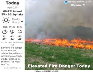
Weather Story 
Local Radar
Regional Radar - West View
Regional Radar - East View |
Hazards
National Briefing
Hazardous Weather Outlook
Skywarn
View Local Storm Reports
Submit A Storm Report
Winter Weather
Summer Weather
Beach Hazards
Local Forecasts
Marine
Aviation
Fire
Local Text Products
Local Precip Forecast
Hourly Forecast Graphics
Forecast Discussion
Climate
Local Climate Products
Normals/Records MKE/MSN
CoCoRaHS
Historic Events For Srn WI
Lightning Plot Archive
Daily Climate Graphics
US Dept of Commerce
National Oceanic and Atmospheric Administration
National Weather Service
Milwaukee/Sullivan, WI
N3533 Hardscrabble Road
Dousman, WI 53118
262-965-2074
Comments? Questions? Please Contact Us.


