
Wildfires and poor air quality continue for the Pacific Northwest, Rockies and extended into the Plains. Severe thunderstorms possible for the northern Plains and upper Midwest on Monday along a frontal boundary. Another boundary will focus showers and thunderstorms for the eastern seaboard with localized heavy rainfall possible. For Alaska, a strong Bering Sea storm will bring winds and rainfall. Read More >
Overview: Winter Storm January 10-11, 2020
|
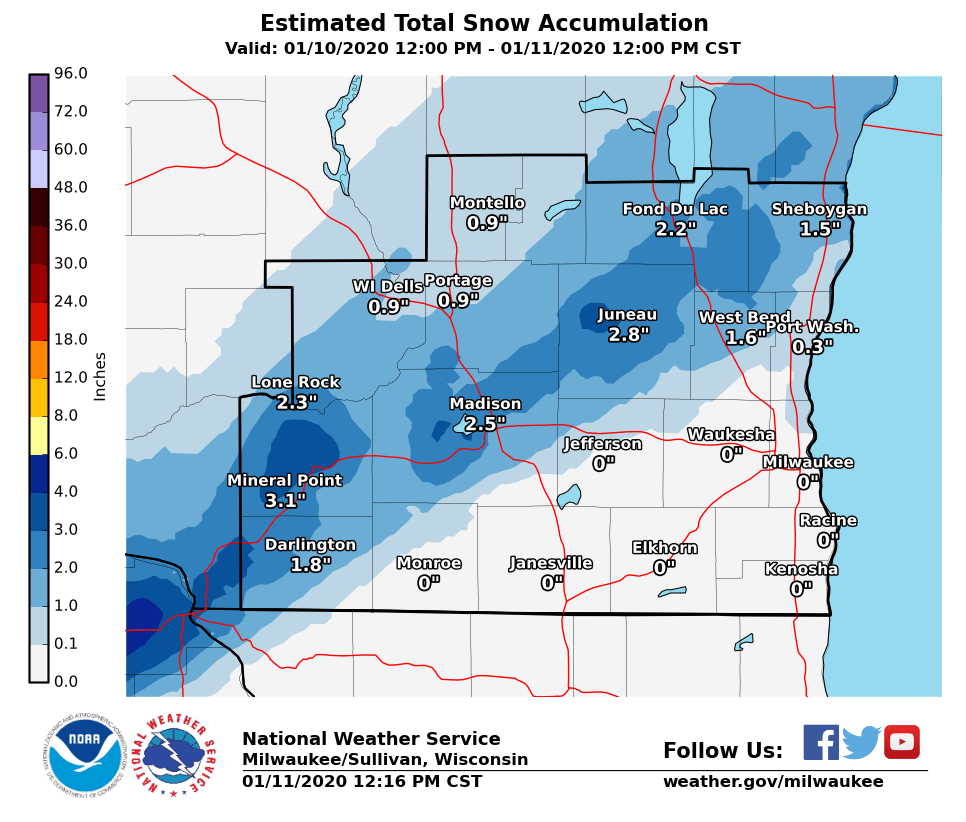
A large potent storm system worked its way across the central part of the country on the weekend of January 10th and 11th. This system brought severe thunderstorms and heavy rains across the southern Midwest down to the Gulf Coast, while it brought two rounds of winter weather across southern Wisconsin. The first round of winter weather began Friday evening as a surface low moved across central Illinois. This brought a mix of wintry precipitation across central and southern Wisconsin through Friday night. There was a distinct cutoff between precipitation type from line from Monroe to Port Washington. For areas to the north of this line, they initially saw a wintry mix of freezing rain, graupel, and ice pellets which formed a thin layer of ice between a few hundredths of an inch up to 0.2 inches, but eventually transitioned to mostly snow by late evening. Anywhere from around an inch up to 3 inches of snowfall was observed through midnight. On the other hand, areas south and east of the line remained at or just above freezing and experienced rain initially and then changed to freezing rain overnight. Areas south of the line from Monroe to Port Washington observed ice accumulations around 0.1 inch up to around 0.3 inches. These wintry conditions created hazardous travel that continue into Saturday morning across southern Wisconsin as some light wintry precipitation of freezing drizzle and light snow lingered through the morning off the Lake. In addition to the wintry weather, strong northeasterly onshore winds developed across the area Saturday. These strong winds with gusts around 40-50 mph combined with the record high Lake Michigan water levels resulted in significant lakeshore flooding, especially for areas along Milwaukee's lakefront. By Saturday afternoon, the upper-level trough pushed into the region and the second round of winter weather began producing light to moderate snow across the southern Wisconsin. Although, initial forecasts called for higher snowfall totals, a easterly shift in the track of the surface low limited snowfall for areas west of a line from Fond du Lac down to Monroe. This shift also kept snowfall amounts on the lower end east of the line with anywhere around 1 inch up to around 4 inches. The heaviest snows occurred along a line just south of Sheboygan down to Waukesha.
|
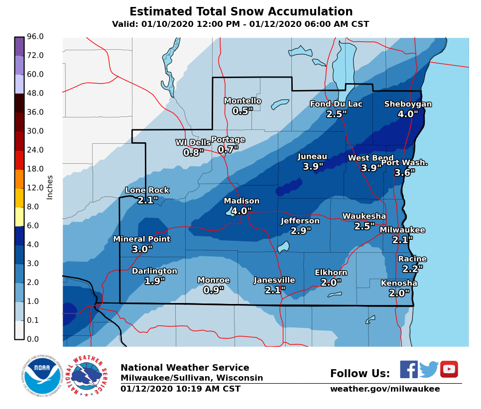 2 Day Snowfall Totals |
Snowfall
First Round of Winter Weather: Wintry Mix
 |
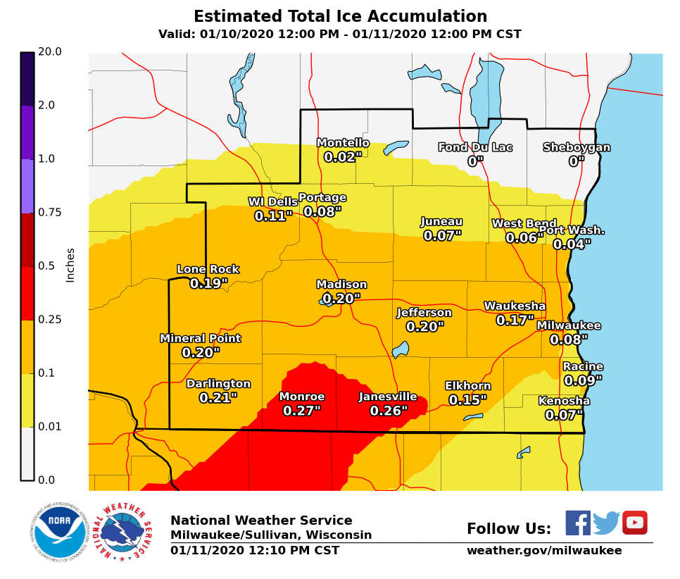 |
| Round 1 Snowfall Totals: 12 PM January 10, 2020 to 12 PM January 11, 2020 | Round 1 Ice Accumulations: 12 PM January 10, 2020 to 12 PM January 11, 2020 |
Second Round of Winter Weather: Snow
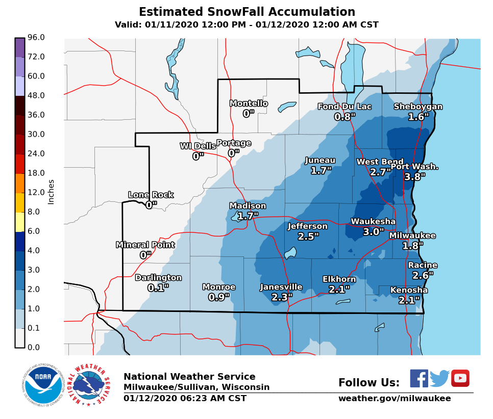 |
| Round 2 Snowfall Totals: 12 PM January 11, 2020 to 12 AM January 12, 2020 |
Total Snowfall
|
| Two Day Snowfall from January 10-12, 2020 |
Forecast Challenges
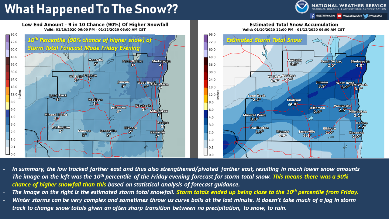
What happened to all the snow that was forecast early on??
The biggest factor was that the low tracked farther east and thus also strengthened/pivoted farther east, resulting in much lower snow amounts. Based on the forecast and model guidance right before the storm moved in, there was about a 90% of getting snow totals greater than what we ended up receiving. Winter storms can be very complex and sometimes throw us curve balls at the last minute. It doesn't take much of a jog in storm track to change snow totals given an often sharp transition between no precipitation, to snow, to rain.
 |
Radar
Loop of Winter Weather From 3 PM Friday to 12 AM Sunday (01/10/2020 - 01/12/2020)
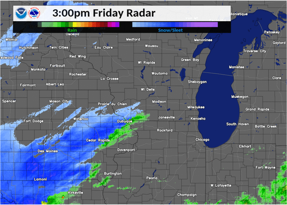 |
| 3 PM Friday to 12 AM Sunday (01/10/2020 - 01/12/2020) |
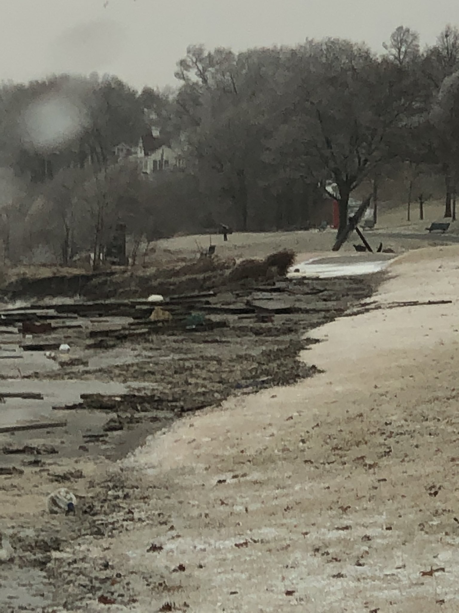
Lakeshore Flooding
A period of strong north to northeasterly onshore winds gusting 40 to 50 mph at times combined with near record high Lake Michigan water levels resulted in significant lakeshore flooding in parts of Milwaukee. The flooding resulted in the closure of the Port of Milwaukee. Approximately 60 to 70% of Jones Island which is the home of the Port of Milwaukee was flooded on Saturday (01/11/2020). The lakeshore flooding also caused damage to a pier at the South Shore Yacht Club, located south of the Port of Milwaukee. Peak wind gust at KMKE was 47 kts from NNE this morning.
 |
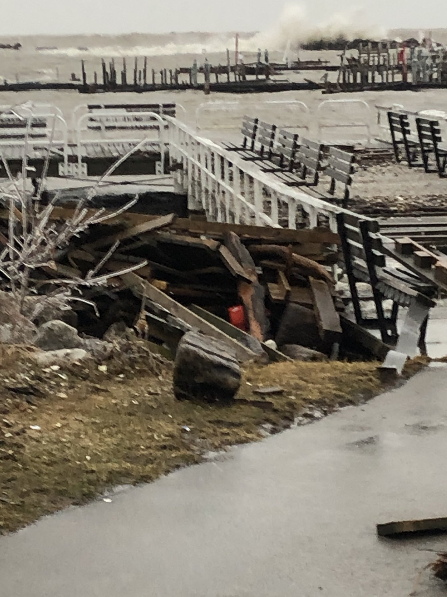 |
| Lakeshore Flood Damage | Lakeshore Flood Damage |
Storm Reports
...Highest Wind Gusts for Saturday 01/11/2020...

LOCATION                     SPEED     TIME/DATE
RACINE-BATTEN AIRPORT        58 MPH    0620 AM 01/11
KENOSHA                      55 MPH    0600 AM 01/11
MILWAUKEE-GEN MITCHELL ARPT  54 MPH    0728 AM 01/11
KENOSHA AIRPORT              51 MPH    0803 AM 01/11
SHEBOYGAN                    47 MPH    0200 AM 01/11
PLEASANT PRAIRIE             44 MPH    0548 AM 01/11
MONROE                       41 MPH    0815 AM 01/11
FOND DU LAC AIRPORT          41 MPH    0159 AM 01/11
MADISON-DANE COUNTY AIRPORT  40 MPH    0417 AM 01/11
1 ENE MILWAUKEE              38 MPH    0240 AM 01/11
SHEBOYGAN-AIRPORT            38 MPH    0811 AM 01/11
HORICON                      37 MPH    0328 AM 01/11
JUNEAU                       36 MPH    0855 AM 01/11
WAUKESHA AIRPORT             36 MPH    0535 AM 01/11
BURLINGTON                   35 MPH    0455 AM 01/11
BROOKFIELD                   35 MPH    0358 AM 01/11
MILWAUKEE LAWREN             35 MPH    0335 AM 01/11
WEST ALLIS                   35 MPH    0323 AM 01/11
 |
Media use of NWS Web News Stories is encouraged! Please acknowledge the NWS as the source of any news information accessed from this site. |
|

