
Tropical Depression Two is expected to gradually strengthen and could bring tropical storm conditions to the Florida Panhandle beginning late Monday. Areas of flash flooding will be possible through Thursday along the eastern and central Gulf Coast. Severe thunderstorms will develop and move along a cold front crossing the Upper Midwest Monday, and through the Ohio Valley/Mid-Atlantic on Tuesday. Read More >
Overview
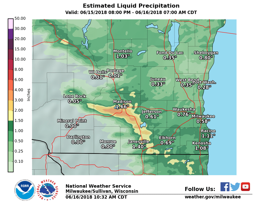
Slow moving thunderstorms repeatedly affected portions of Madison and the neighboring communities of Stoughton, Fitchburg and McFarland between 11 pm CDT June 15th and 2 am CDT June 16th. The thunderstorms deposited heavy rainfall between 3 and 5 inches in some locations, which resulted in spotty flash flooding. A portion of the beltline between Park Street and John Nolen Drive was flooded causing several stalled vehicles. Three feet of water was reported on highway 14 in the town of Madison. Several flooded roads were reported in Stoughton and Fitchburg as well.
Some of the heavier rainfall reports included 4.12" from a CoCoRahs report located 5 miles southwest of downtown Madison and 3.35" 1 mile east of McFarland.
Radar/Photos (click for larger view)
 |
 |
 |
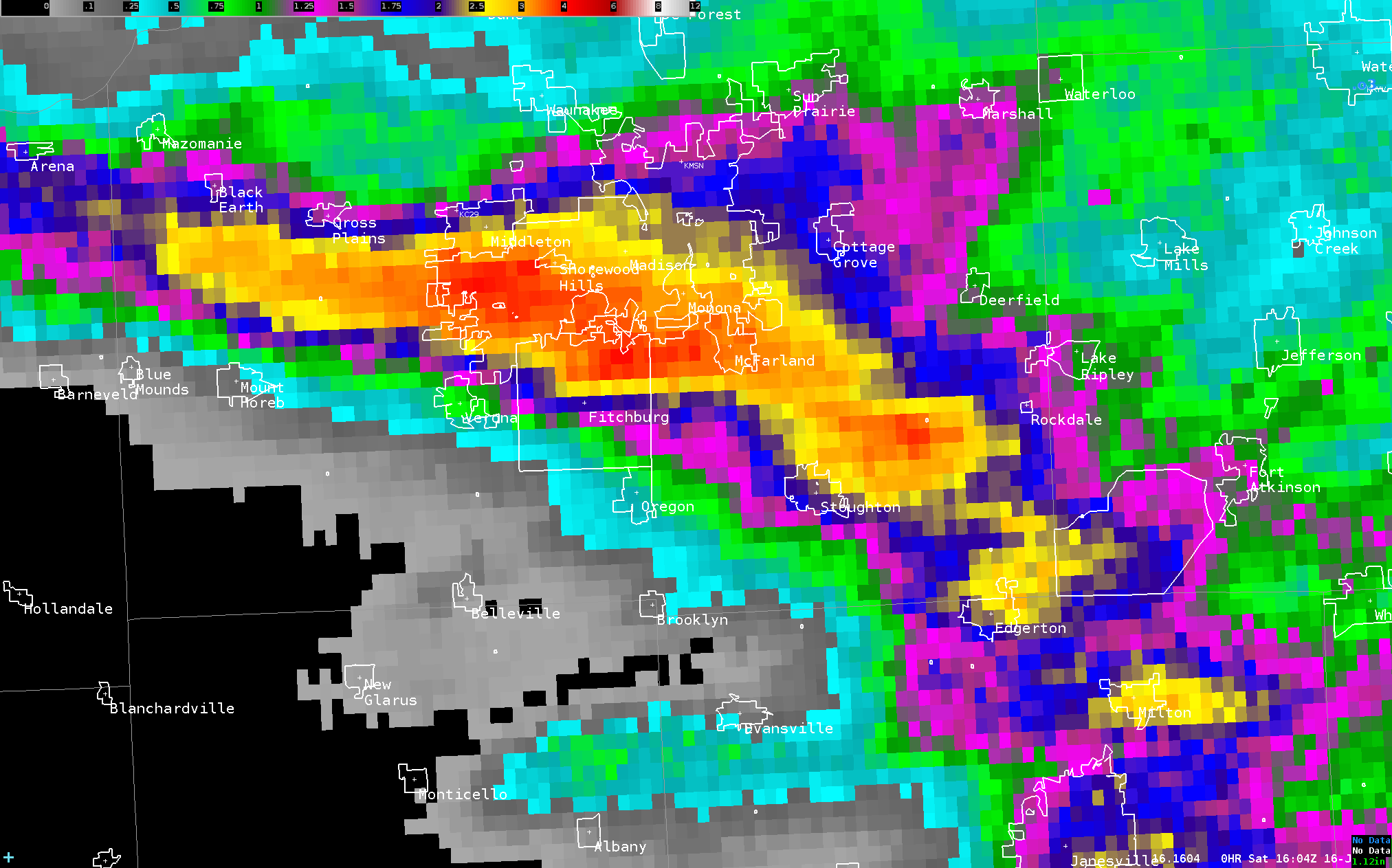 |
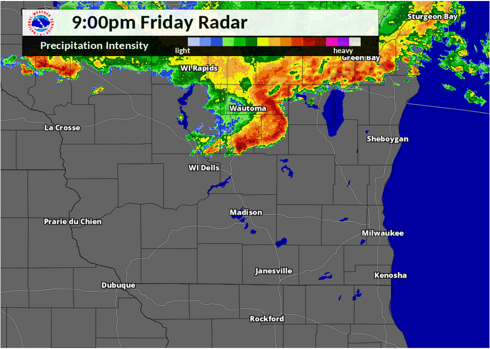
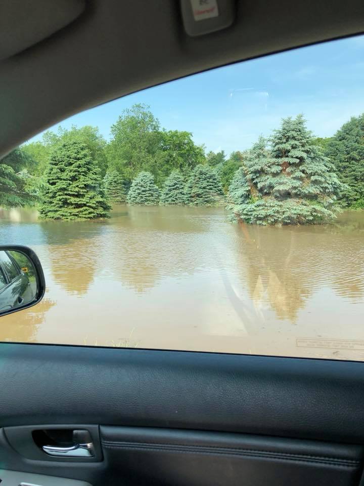
| Radar Loop | Middleton flooding - Intersection of Valley View Road and Meadow Road | Estimated Overnight Rainfall | Closeup of Dane County Rainfall |
Storm Reports
PRELIMINARY LOCAL STORM REPORT...SUMMARY
NATIONAL WEATHER SERVICE MILWAUKEE/SULLIVAN WI
1114 AM CDT SAT JUN 16 2018

..TIME...   ...EVENT...      ...CITY LOCATION...     ...LAT.LON...
..DATE...   ....MAG....      ..COUNTY LOCATION..ST.. ...SOURCE....
            ..REMARKS..

1015 AM     HEAVY RAIN       2 SSW MADISON           43.06N 89.40W
06/16/2018  M4.43 INCH       DANE               WI   PUBLIC

            ALSO SMALL HAIL.

0900 AM     HEAVY RAIN       4 SSW SHOREWOOD HILLS   43.03N 89.49W
06/16/2018  M4.12 INCH       DANE               WI   COCORAHS

            5 SW MADISON, STATION WI-DA-3.

0119 AM     HEAVY RAIN       STOUGHTON               42.92N 89.20W
06/16/2018  M4.04 INCH       DANE               WI   MESONET

            TOTAL SO FAR AT MESONET STATION STGHT,
            STOUGHTON.

0900 AM     HEAVY RAIN       2 S MIDDLETON           43.07N 89.51W
06/16/2018  M3.88 INCH       DANE               WI   COCORAHS

            6.1 W MADISON, STATION WI-DA-45.

0836 AM     HEAVY RAIN       4 SE CROSS PLAINS       43.08N 89.59W
06/16/2018  M3.80 INCH       DANE               WI   PUBLIC


0119 AM     HEAVY RAIN       1 ESE SHOREWOOD HILLS   43.07N 89.43W
06/16/2018  M3.80 INCH       DANE               WI   MESONET

            TOTAL SO FAR AT MESONET STATION MDSNW, 1 ESE
            SHOREWOOD HILLS.

0900 AM     HEAVY RAIN       1 SSW SHOREWOOD HILLS   43.06N 89.46W
06/16/2018  M3.76 INCH       DANE               WI   COCORAHS

            3.7 WSW MADISON, STATION WI-DA-13.

1000 AM     HEAVY RAIN       1 N FITCHBURG           43.00N 89.42W
06/16/2018  M3.50 INCH       DANE               WI   PUBLIC

            ON LACY RD. REPORT VIA FACEBOOK.

0900 AM     HEAVY RAIN       1 W SHOREWOOD HILLS     43.08N 89.47W
06/16/2018  M3.40 INCH       DANE               WI   COCORAHS

            4 W MADISON, STATION WI-DA-39.

0900 AM     HEAVY RAIN       MCFARLAND               43.02N 89.28W
06/16/2018  M3.35 INCH       DANE               WI   COCORAHS

            1 E MCFARLAND, STATION WI-DA-14.

0824 AM     HEAVY RAIN       1 NE MCFARLAND          43.03N 89.28W
06/16/2018  M3.23 INCH       DANE               WI   TRAINED SPOTTER

            OVERNIGHT RAINFALL REPORTED VIA SOCIAL
            MEDIA. 1.5 INCH DIAMETER BRANCH DOWN AS
            WELL.

0900 AM     HEAVY RAIN       1 SSW MIDDLETON         43.08N 89.52W
06/16/2018  M2.88 INCH       DANE               WI   COCORAHS

            6.4 W MADISON, STATION WI-DA-46.

0711 AM     HEAVY RAIN       2 SW SHOREWOOD HILLS    43.06N 89.48W
06/16/2018  M2.70 INCH       DANE               WI   CO-OP OBSERVER

            CHMW3 - CHARMANY FARM IN MADISON.

0725 AM     HEAVY RAIN       1 SSW MIDDLETON         43.10N 89.51W
06/16/2018  M2.58 INCH       DANE               WI   CO-OP OBSERVER

            WASTEWATER TREATMENT PLANT.

0400 AM     HEAVY RAIN       3 NE VERONA             43.02N 89.49W
06/16/2018  M2.56 INCH       DANE               WI   AMATEUR RADIO

            STORM TOTAL FROM 1155PM FRIDAY THROUGH 4AM
            SATURDAY.

0841 AM     HEAVY RAIN       1 NNE MONONA            43.07N 89.33W
06/16/2018  M2.50 INCH       DANE               WI   PUBLIC

            OVERNIGHT RAINFALL REPORTED CLOSE TO MONONA
            GOLF COURSE. REPORTED VIA SOCIAL MEDIA.

0704 AM     HEAVY RAIN       MCFARLAND               43.02N 89.29W
06/16/2018  M2.43 INCH       DANE               WI   TRAINED SPOTTER


0900 AM     HEAVY RAIN       5 ENE MOUNT HOREB       43.03N 89.63W
06/16/2018  M2.31 INCH       DANE               WI   COCORAHS

            5.5 WNW VERONA NEAR RILEY, STATION WI-DA-49.

0941 AM     HEAVY RAIN       1 E MAPLE BLUFF         43.11N 89.35W
06/16/2018  M2.28 INCH       DANE               WI   COCORAHS

            3 NE MADISON, STATION WI-DA-52.

0819 AM     HEAVY RAIN       2 N VERONA              43.02N 89.53W
06/16/2018  M2.25 INCH       DANE               WI   PUBLIC

            LOCATION JUST EAST OF UNIVERSITY RIDGE GOLF
            COURSE. OVERNIGHT RAINFALL REPORTED VIA
            SOCIAL MEDIA.

0941 AM     HEAVY RAIN       1 W DE FOREST           43.25N 89.36W
06/16/2018  M1.75 INCH       DANE               WI   PUBLIC

            OVERNIGHT RAINFALL. REPORTED VIA SOCIAL
            MEDIA.

0839 AM     HEAVY RAIN       1 NW WIND POINT         42.79N 87.79W
06/16/2018  M1.50 INCH       RACINE             WI   PUBLIC

            OVERNIGHT RAINFALL REPORTED NEAR
            INTERSECTION OF HIALEAH DRIVE AND ERIE
            STREET. REPORTED VIA SOCIAL MEDIA.

0816 AM     HEAVY RAIN       1 S WIND LAKE           42.81N 88.16W
06/16/2018  M1.05 INCH       RACINE             WI   PUBLIC


0115 AM     HAIL             4 WNW ARENA             43.18N 89.99W
06/16/2018  M0.75 INCH       IOWA               WI   PUBLIC

            REPORTED VIA SOCIAL MEDIA.

1050 PM     TSTM WND DMG     1 W DE FOREST           43.25N 89.36W
06/15/2018                   DANE               WI   PUBLIC

            LARGE OAK TREE DOWN ABOUT 1 MILE WEST OF
            DOWNTOWN DE FOREST. REPORTED VIA SOCIAL
            MEDIA. TIME ESTIMATED.

1230 AM     FLASH FLOOD      3 WSW MONONA            43.04N 89.38W
06/16/2018                   DANE               WI   911 CALL CENTER

            FOLLOW UP ON FLOODING: SEVERAL STALLED
            VEHICLES ON THE BELTLINE BETWEEN MILE
            MARKERS 261 AND 263, WHICH IS PARK ST AND
            JOHN NOLAN DR. ALSO 3 FEET OF WATER IN HWY
            14 IN TOWN OF MADISON. WATER INTO SOME HOMES
            ON SOUTHWEST SIDE OF CITY. WATER INTO SOME
            UW CAMPUS BUILDINGS.

0126 AM     FLASH FLOOD      MADISON                 43.08N 89.39W
06/16/2018                   DANE               WI   LAW ENFORCEMENT

            NUMEROUS VEHICLES STRANDED. WATER ENTERING
            LOWER LEVELS OF HOUSES AND APARTMENT
            BUILDINGS. FIRE DEPARTMENT PERFORMING WATER
            RESCUES.
Latest Storm Reports in text format and graphical format.
 |
Media use of NWS Web News Stories is encouraged! Please acknowledge the NWS as the source of any news information accessed from this site. |
|

