
Widespread life-threatening flash and urban flooding will continue to pose a significant threat to life and property in south-central Texas. Catastrophic fiver flooding, with rapid rises on small streams, arroyos, and typically dry washes, is expected. Monsoonal showers persist across the Great Basin and Southwest with greatest flash flooding in southern Arizona. Read More >
Milwaukee/Sullivan, WI
Weather Forecast Office
The National Weather Service in Milwaukee/Sullivan will be conducting a survey of the southern Washington County area on Thursday. Radar and spotter reports confirm a likely tornado touchdown in the area between Monches in far northern Waukesha County to the Hubertus area.
Minor structural damage and tree damage was reported in the vicinity.
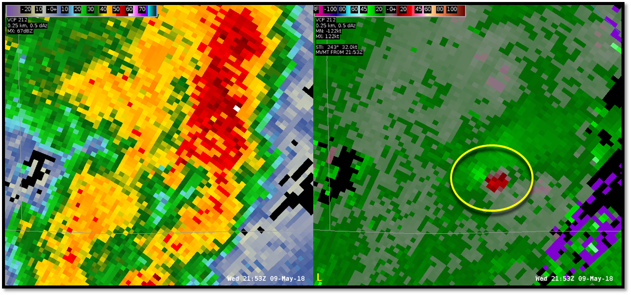
The below image depicts the Milwaukee/Sullivan radar imagery at 4:53 pm. The reflectivity is on the left and the likely tornadoes circulation is on the right. The circulation measured on radar was about 1300 ft above the ground. This was about the time a Tornado Warning was issued for southern Washington County.
Check back for more details later Thursday, after the survey.
Hazards
National Briefing
Hazardous Weather Outlook
Skywarn
View Local Storm Reports
Submit A Storm Report
Winter Weather
Summer Weather
Beach Hazards
Local Forecasts
Marine
Aviation
Fire
Local Text Products
Local Precip Forecast
Hourly Forecast Graphics
Forecast Discussion
Climate
Historic Events For Srn WI
Lightning Plot Archive
Daily Climate Graphics
Local Climate Products
Normals/Records MKE/MSN
CoCoRaHS
US Dept of Commerce
National Oceanic and Atmospheric Administration
National Weather Service
Milwaukee/Sullivan, WI
N3533 Hardscrabble Road
Dousman, WI 53118
262-965-2074
Comments? Questions? Please Contact Us.

