August 2026 Climate Summaries
Mobile Alabama and Pensacola Florida Area
National Weather Service Mobile Alabama
September 16, 2026
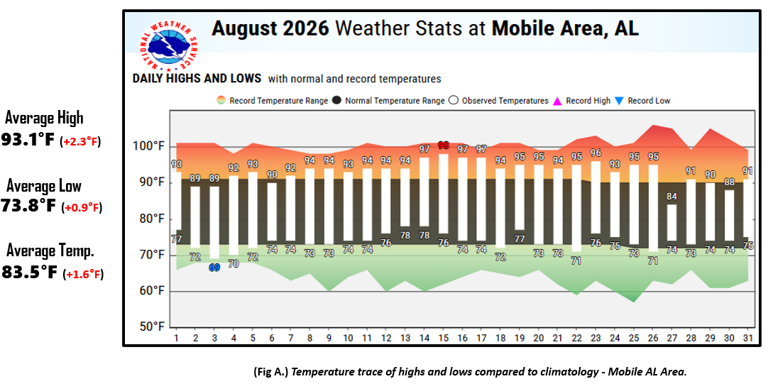
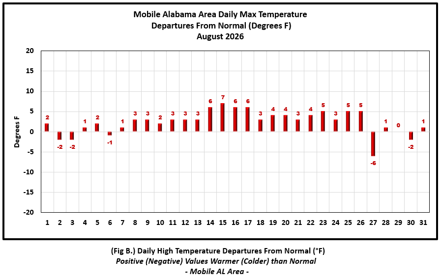
August 2026 in Review - For the Mobile area, daily high temperatures started off close to normal to open the month but warmed to well above normal from the 8th to the 26th when highs averaged 4.1° above normal for this period. Low temperatures for the month averaged closer to normal within a degree off the pace. For the Pensacola area, there was more variability in both the highs and lows about the means. Despite this, the monthly highs and lows averaged out to within a half degree of normal. As far as temperature extremes, an uneventful month was had as no records were recorded at both Mobile and Pensacola.
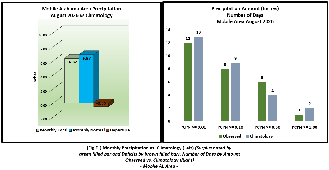
The rain gauge collected over a half foot of rain at Mobile for the month, but still came up a bit short of normal August rainfall by near a half inch. On the flip side, Pensacola saw a surplus in monthly rainfall with over eight inches finding the gauge and slightly over three quarters of an inch above normal. There was one record wet day at Pensacola and that was the 19th when 2.00" of rain saw the gauge.
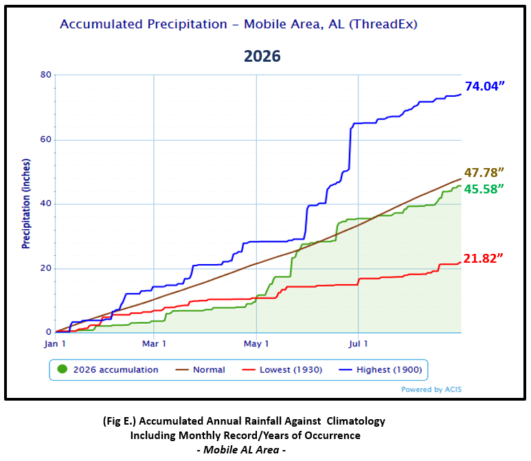
Mobile Alabama Area [Climate Normal Period 1991-2020, Climate Record Period 1872 to Present]- The average monthly high of 93.1° was 2.3° above normal. The average monthly low of 73.8° was 0.9° above normal. The average temperature was 83.5°, 1.6° above normal. The highest temperature for the month on the 15th at 98°, was 7° above the normal for the date. The lowest temperature for the month settled to 69° on the morning of the 3rd, 4° below normal for the date. No record temperatures were reached at Mobile for the month of August. (Fig. A) shows a bar graphical representation of how the Mobile area daily temperatures compared to the seasonal normal daily highs and lows.(Figs. B and C) shows bar graph departures from normal. The rain gauge measured 6.32" (Fig. D), 0.55" below the monthly normal. (Fig. E) shows the annual accumulated precipitation has moved above 45" to 45.58", but is in deficit by 2.20" below normal.
August top records for the month during the Period of Record for the Mobile Area:
Click on the Mobile Alabama area climate graphics below to expand:
|
|

|
|
|
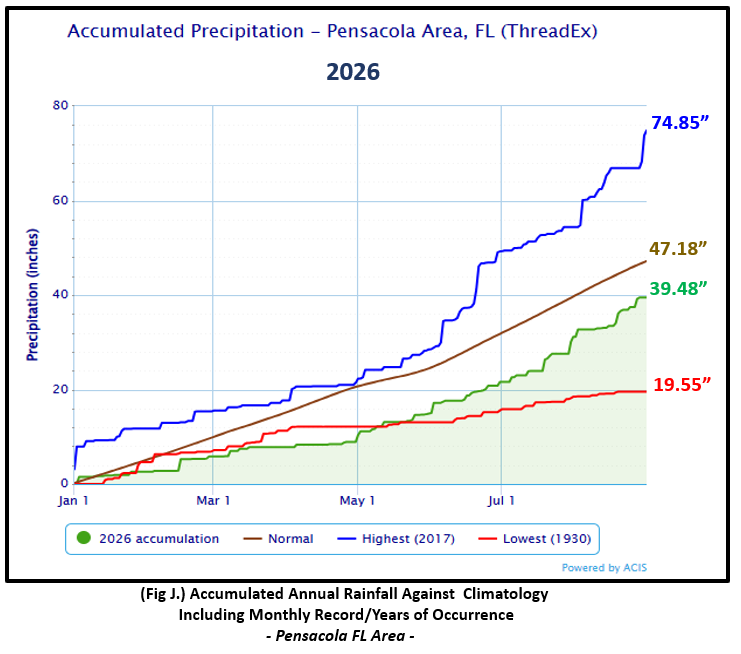
Pensacola Florida Area [Climate Normal Period 1991-2020, Climate Record Period 1879 to Present] - The average monthly high of 90.7° was 0.3° below normal. The average monthly low of 75.5° was 0.5° above normal. The average temperature of 83.1° was 0.1° above normal. The highest temperature for the month rose to 96° on the 19th and was 5° above the normal for the date. The lowest temperature for the month, 70°, on the morning of the 20th was 5° below the normal high for the date. No record temperatures were reached at Pensacola for the month of August. (Fig. F) shows a bar graphical representation of how the Pensacola area daily temperatures compared to the seasonal normal daily highs and lows. (Figs. G and H) shows the daily high/low temperature departures from normal. The rain gauge at Pensacola captured 8.30", (Fig. I), 0.80" above the monthly normal. On the 19th, two inches of rain fell and broke a one day rainfall. The previous amount was 1.86" set on this day way back in 1932. (Fig. J) shows Pensacola's annual accumulated precipitation of 39.48", is remains in a large deficit of 7.70" below normal to date.
August top records for the month during the Period of Record for the Pensacola Area:
Click on the Pensacola Florida area climate graphics below to expand:

|

|

|

|
|
Additional August 2026 Climatology and Topics
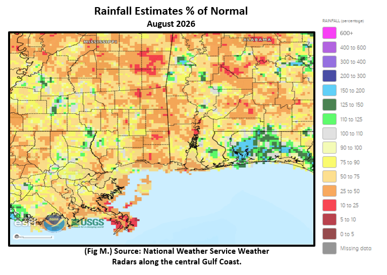
The footprint of highest rainfall for the month was more focused mostly along the I-10 corridor over the northwest Florida Panhandle. Over the panhandle, there were pockets of 10 to 15" of monthly rains equating to roughly 150 to 200% of normal. Much of the remainder of the local area was mostly short of normal rainfall by some 2 to 5 inches. Drought began to expand over the local area by the end of August. (Fig. K) shows the areal distribution of monthly rainfall, (Fig. L) shows the areal rainfall departures from normal and (Fig. M).

|

|
|
September 2026 Climatology, Seasonal Climatology and Outlooks:
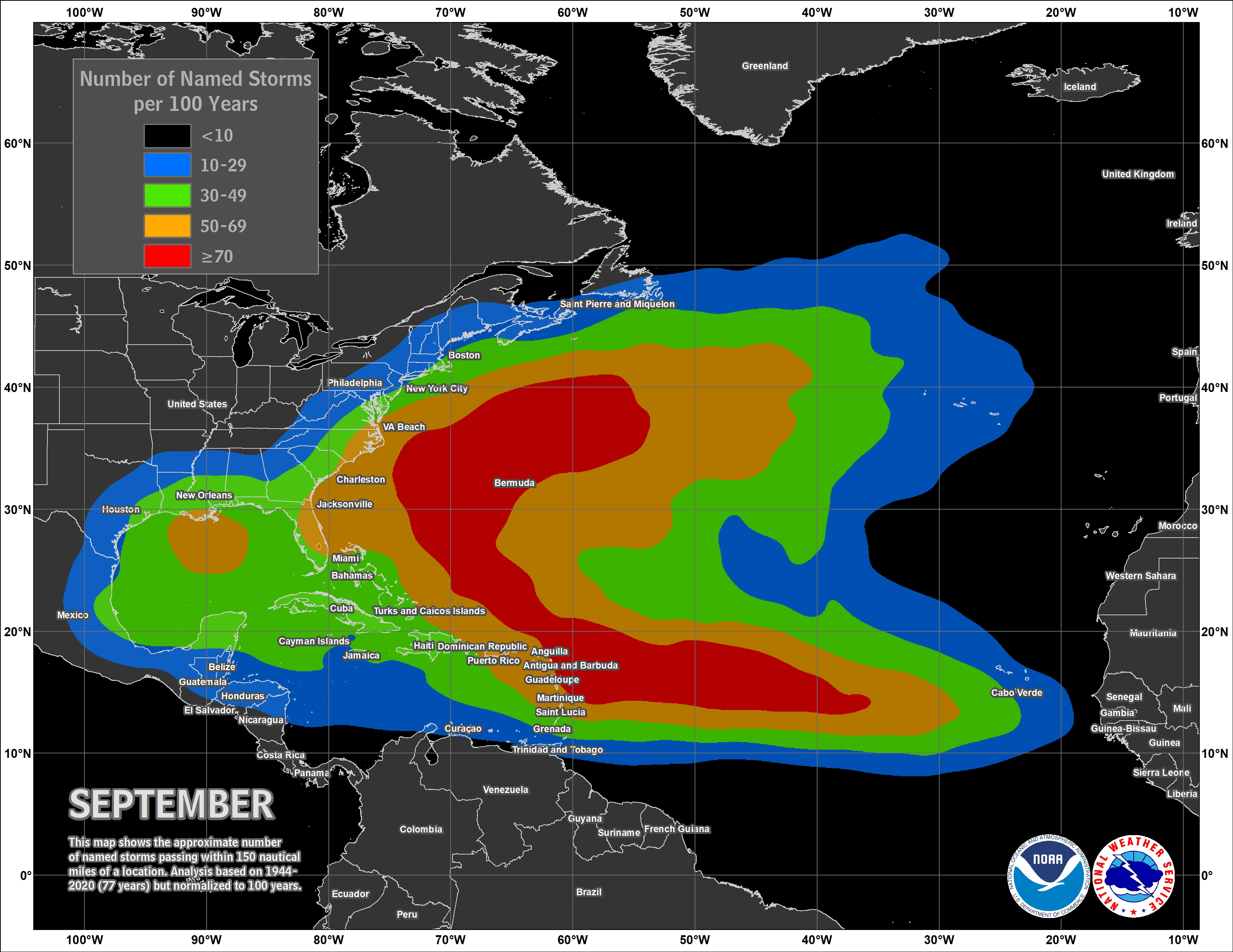
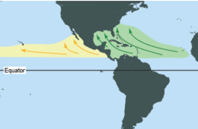
Looking ahead to September, temperatures are favored to lean above normal for much of the continental U.S. Equal chances of above or below normal precipitation is favored over the southeast U.S. to across the central Gulf coast. The typical origin hotspots for tropical cyclone activity during the month of September generally over the central into the western Atlantic. NOAA updated its Atlantic Basin Hurricane outlook for tropical activity earlier in August and the outlook suggests activity to be below normal in occurrence as we continue into the peak of hurricane season as a strong El Niño has created atmospheric conditions that are not conducive for development. Regardless, all it takes is one to make it a bad year and it's highly encouraged to review your hurricane preparedness. Click on the Preparedness Tab on the NWS Mobile Tropical Webpage. Lastly, due to dryness over the local area, drought is making a return. A drought link is provided below to monitor trends.
Click on the snap shots below to expand:
 September Normals September Normals |

|

Outlook |
|

|
|
|

|
Additional Climate Links:
The National Weather Service Mobile Alabama's Climate and Past Weather page provides climate data at your fingertips for many observation points in the local forecast area by accessing the NOWData tab as well as many other climate resources. The Climate Prediction Center Link provides short and longer range climatic outlooks and education about the larger scale global circulations that impact temperatures and weather. With the large agriculture and farming presence along the central Gulf coast, the Drought Monitor link provides updates on drought trends and impacts. Another very helpful resource is the Community Collaborative Rain Hail and Snow (CoCoRaHS) network, which is a large group of volunteers working together to measure and map precipitation (rain, hail, and snow). The aim of CoCoRaHS is to provide the highest quality data for natural resource, education and research applications. You can be a part of the CoCoRaHS team by becoming a volunteer rainfall observer.






 Follow us on X
 Follow us on Facebook
 Follow us on YouTube
 MOB RSS Feed
