December 2021 Climate Summaries
(Including Annual ReCap)
Mobile Alabama and Pensacola Florida Area
National Weather Service Mobile Alabama
January 5, 2022
December 2021 in Review - Old man winter was absent as record warmth visited the coastal plain. Opening up the month of December, the long range outlook from the Climate Prediction Center (CPC) favored a good chance that December 2021 over the deep south was going to see above normal temperatures. That indeed verified very well as Mobile and Pensacola experienced average monthly temperatures near a notable and quite astounding 9° above normal. From an average temperature perspective, December 2021 stands as the second warmest on record for the Mobile area and is the top warmest for the Pensacola area. To close out the month, from Christmas Eve to New Year's Eve, daily high temperatures for the Mobile and Pensacola areas averaged 16.4°/15.0° above normal respectively. From Christmas Day to New Year's Eve, morning low temperatures for the Mobile and Pensacola areas averaged a phenomenal 22.1°/23.1° above normal respectively. For the month, the Mobile area experienced four days of both record highs and record high low temperatures. Of these record highs, 82° late in the month turned out to become the new all time warmest day for December in the period of record. The Pensacola area experienced six days where record highs were reached and five days of record high low temperatures. Of the record highs in Pensacola, 81° on a couple days to close out the month joined a few more days of years past occurrence for warmest daily December temperatures reached.
Monthly rainfall was below normal which also verified the monthly long range precipitation outlook for December.
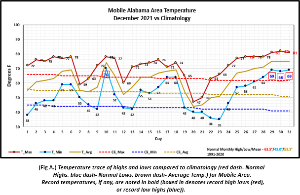
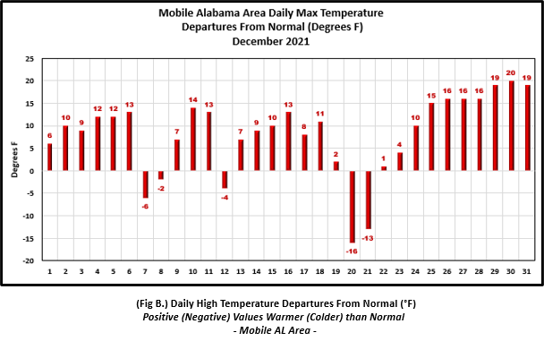
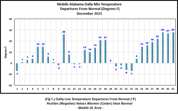
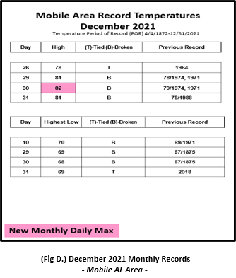
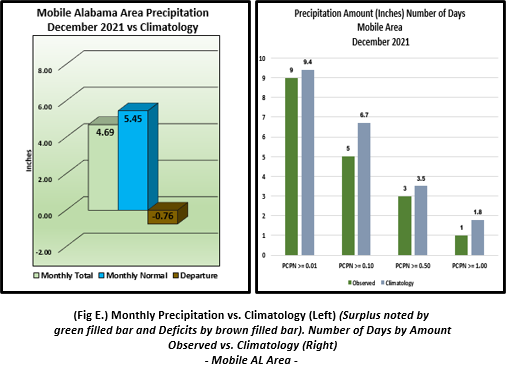
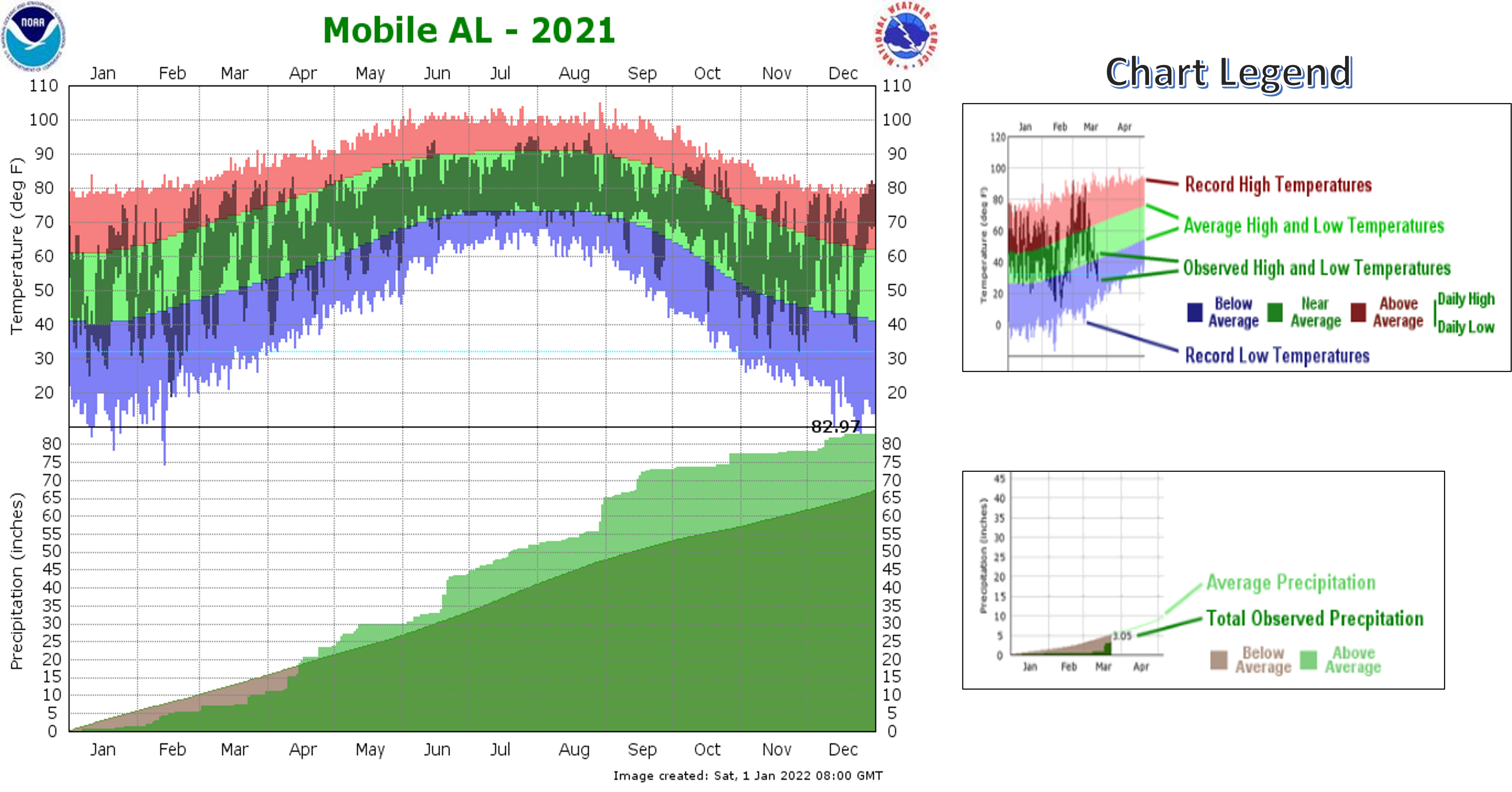
Mobile Alabama Area [Climate Normal Period 1991-2020, Climate Record Period 1872 to Present]- The average monthly high of 71.7° was 8.2° above normal. The average monthly low was 52.3° or 9.3° above normal. The average monthly temperature of 62.0° was 8.7° above normal and stands as the second warmest December's on record for the Mobile area. The highest temperature for the month, 82°, occurred on the 30th. This was both 20° above the normal for the date and set a new daily record for highest temperature in the Mobile area for the month of December. Interestingly, freezing temperatures were not observed. The lowest temperature for the month dipped to 35° on the morning of the 23rd, 7° below normal for this date. (Fig. A) shows a graphical representation of how the Mobile area temperatures compared to the seasonal normal daily highs and lows, which are shown by the colored dashed lines. Bar graphs reflecting the daily high/low temperature departures from normal are provided in (Figs. B and C). Note the extended period of extremes at the latter end of the month. Four record highs and four record high low temperatures were reached. The breakout of these is listed in table format below (Fig. D). The rain gauge collected 4.69" (Fig. E), or 0.76" below normal.
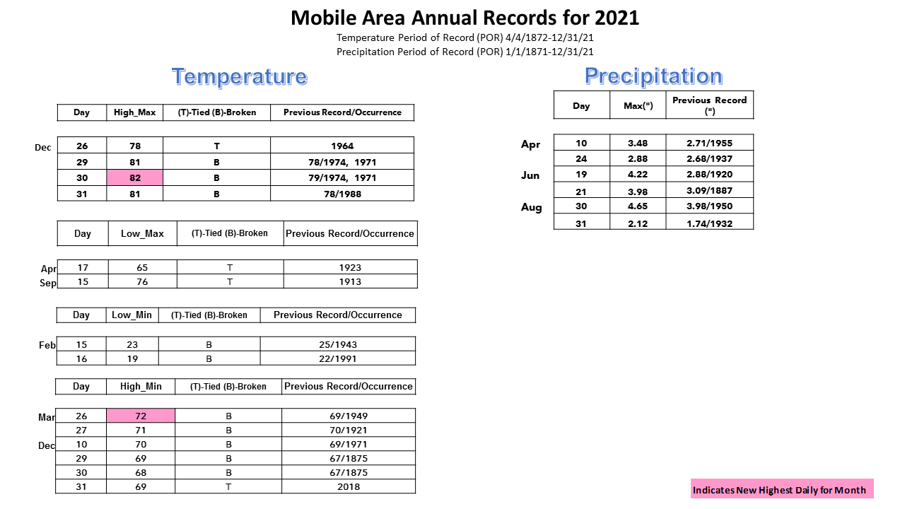
December Top Records for the Month During the Period of Record for the Mobile Area:
Click on the Mobile Alabama area climate graphics below to expand:
|
|
|
|
|
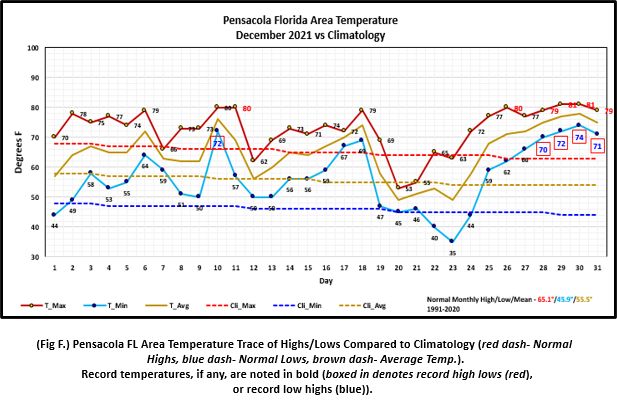
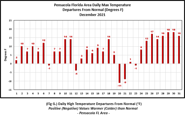
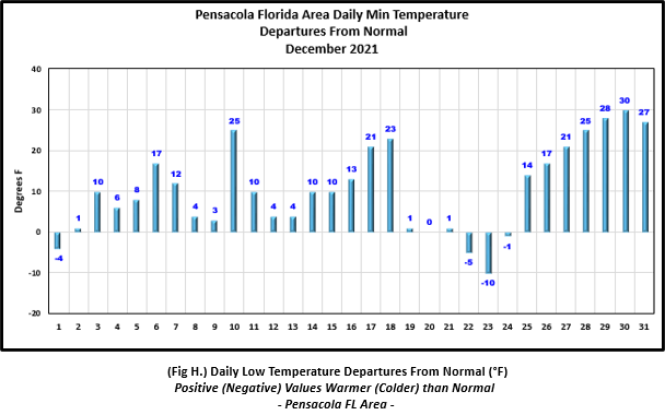
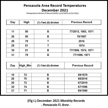
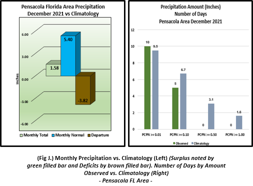
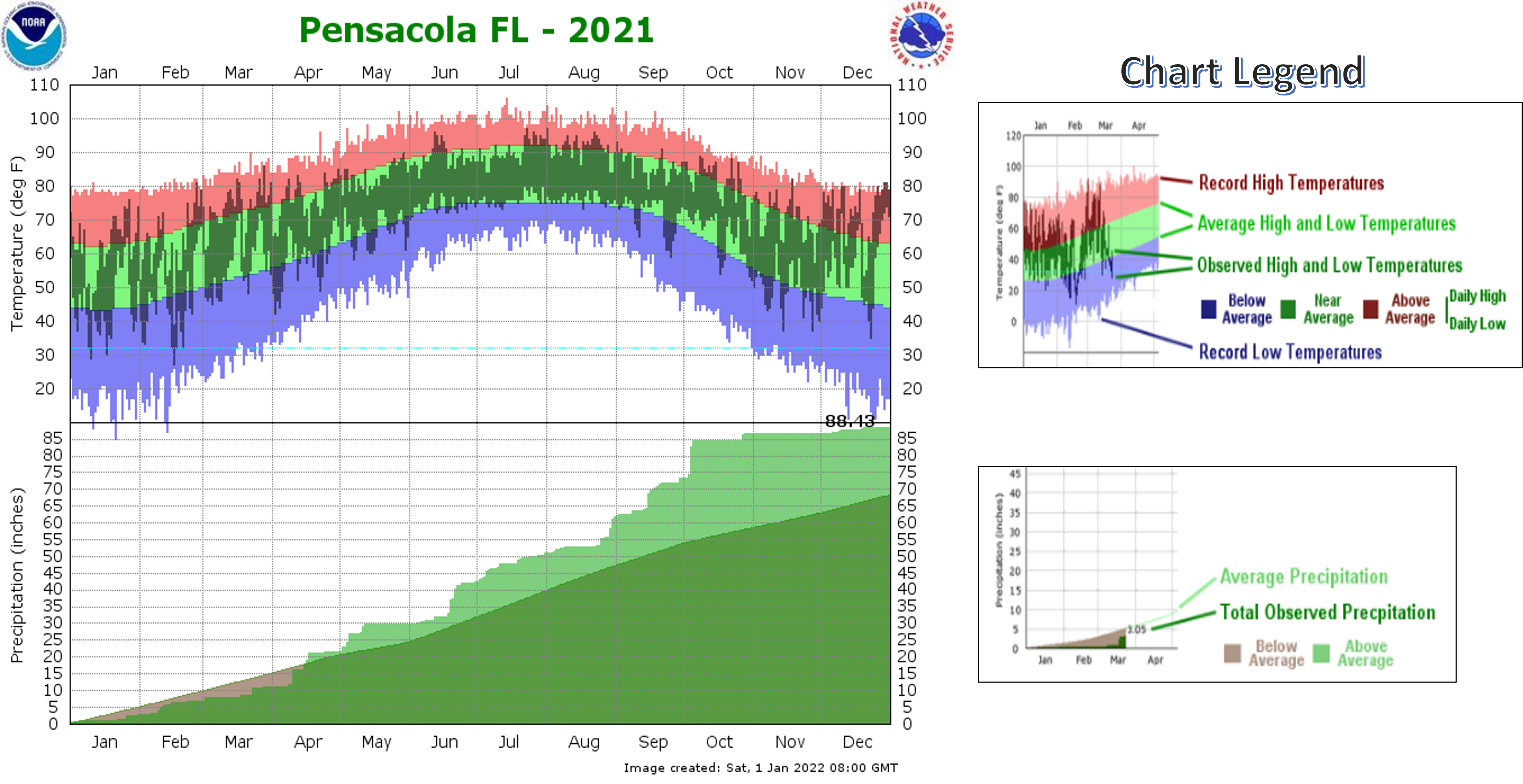
Pensacola Florida Area [Climate Normal Period 1991-2020, Climate Record Period 1879 to Present] - The average monthly high of 72.8° was 7.7° above normal. The average monthly low was 56.5° or 10.6° above normal. The average monthly temperature of 64.6° was 9.1° above normal and now stands as the top warmest December's on record for the Pensacola area. The highest temperature for the month, 81° occurred on both 29th and 30th and was 18° above the normal daily high temperature for both dates. These were also record highs and tied with the warmest daily highs for December with a few other days in past years. Interestingly, freezing temperatures were not observed. The lowest temperature for the month, 35° on the 23rd, was 10° below the normal daily low temperature for this date. (Fig. F) shows a graphical representation of how the Pensacola area temperatures compared to the seasonal normal daily highs and lows, which are shown by the colored dashed lines. (Figs. G and H) shows the daily high/low temperature departures from normal. Note the extended period of extremes at the latter end of the month. Six record highs and five record high low temperatures were reached. The breakout of these is listed in table format below (Fig. I). The rain gauge collected a little over an inch and half of rain (Fig. J), or 3.82" below normal.
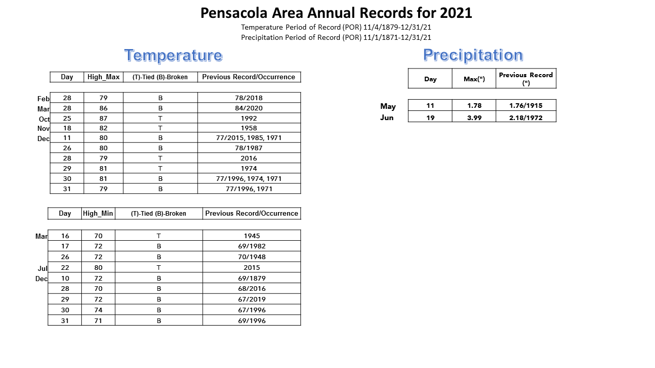
December Top Records for the Month During the Period of Record for the Pensacola Area:
Click on the Pensacola Florida area climate graphics below to expand:
|
|
|
|
|
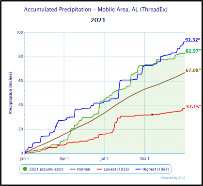
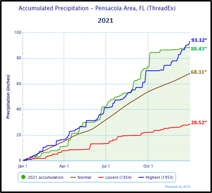
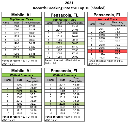
2021 (A Recap) - Mobile saw 14 total days of record temperatures. Of the records, the only record highs for the year surprisingly occurred the last four days of December. The remainder of the records comprised of two record lows both occurring in February, six record high low temperatures and two record low high temperatures. Pensacola recorded 19 days of record temperatures. Of these records, it was nearly evenly split between 10 days of record highs and nine days of record high low temperatures. The average annual temperature at Mobile was 67.3° and at Pensacola, 70.1°. Interestingly, the top eight warmest years for annual average temperatures at Pensacola, including this year, have occurred over the last decade. As far as precipitation is concerned, 2021 was exceedingly wet with the Mobile area breaking into the top 10 wettest years at number 10 on record with a gauge collection of 82.97" or just shy of 16" above normal at +15.89". The Pensacola area collected enough rain to stand at 6th all time wettest years with gauge totals to 88.43" or just over an astounding 20" above normal at +20.12". Rains from Tropical Cyclones Claudette and Ida contributed to the excessive annual rainfalls. The Mobile area saw six days of new record one day rainfall and Pensacola saw two. The individual temperature and precipitation records, their date of occurrence and whether they were broken or tied are provided at the end of the table below.
December 2021 was the top warmest Decembers on record at Pensacola and 2nd warmest on record at Mobile.
2021 Temperature/ Precipitation and Records:
|
|
|
|
|
|
|
2021 Severe Weather: NWS Mobile storm survey teams verified the occurrence of 11 tornadoes impacting the National Weather Service (NWS) Mobile County Warning Area (CWA) with various degrees of damage from EF0 to EF2 intensity Enhanced Fujita Scale (EF) Rating. The following tables provide the distribution of occurrence and a breakout by date/county of occurrence. Details of each survey are provided as a link.

| Location | County | State | Date of Occurrence | EF Scale Rating |
| AQUILLA | CHOCTAW CO. | AL | 3/17/2021 | EF2 |
| WEST BEND | CLARKE CO. | AL | 3/17/2021 | EF2 |
| WHISTLER | WAYNE CO. | MS | 3/17/2021 | EF2 |
| BRANTLEY | CRENSHAW CO. | AL | 3/18/2021 | EF1 |
| LAVACA | CHOCTAW CO. | AL | 3/25/2021 | EF1 |
| HERON BAY | MOBILE CO. | AL | 6/19/2021 | EF0 |
| BREWTON MUNI ARPT | ESCAMBIA CO. | AL | 6/19/2021 | EF0 |
| CASTLEBERRY | CONECUH CO. | AL | 6/19/2021 | EF1 |
| WATKINS BRIDGE | COVINGTON CO. | AL | 6/19/2021 | EF0 |
| SARALAND | MOBILE CO. | AL | 8/30/2021 | EF1 |
| CHOCTAW BLUFF | CLARKE CO. | AL | 8/30/2021 | EF1 |
Additional December 2021 Climatology and Topics
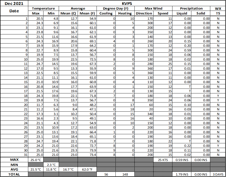
The latest December 2021 monthly summary for Eglin Air Force Base (AFB) - KVPS and Duke Field - KEGI has been received and provided in the table below. The temperatures in the daily tables consists of numbers both in °F/°C. Data courtesy of Mr. David Biggar, Staff Meteorologist, 96th Weather Squadron. Provided by permission.
|
|

|
January 2022 Climatology, Seasonal Climatology and Outlooks:
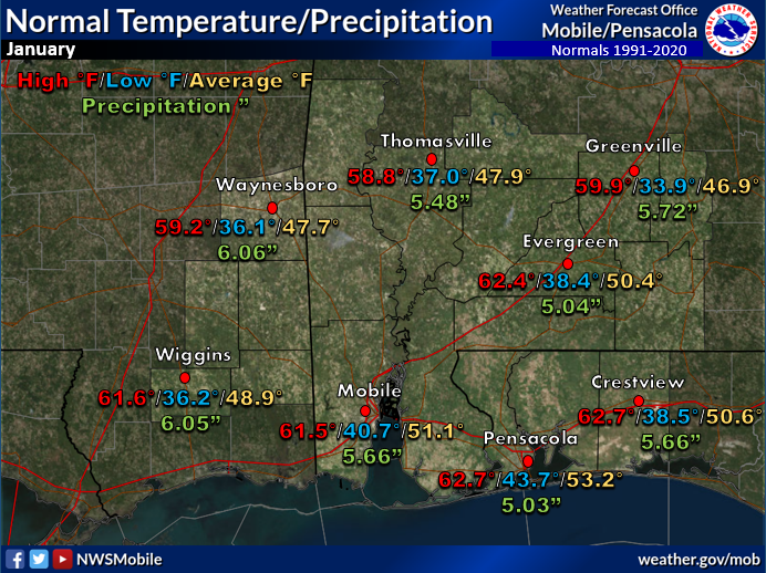
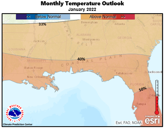
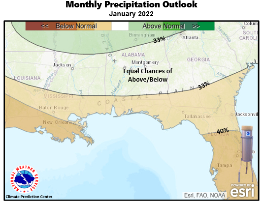
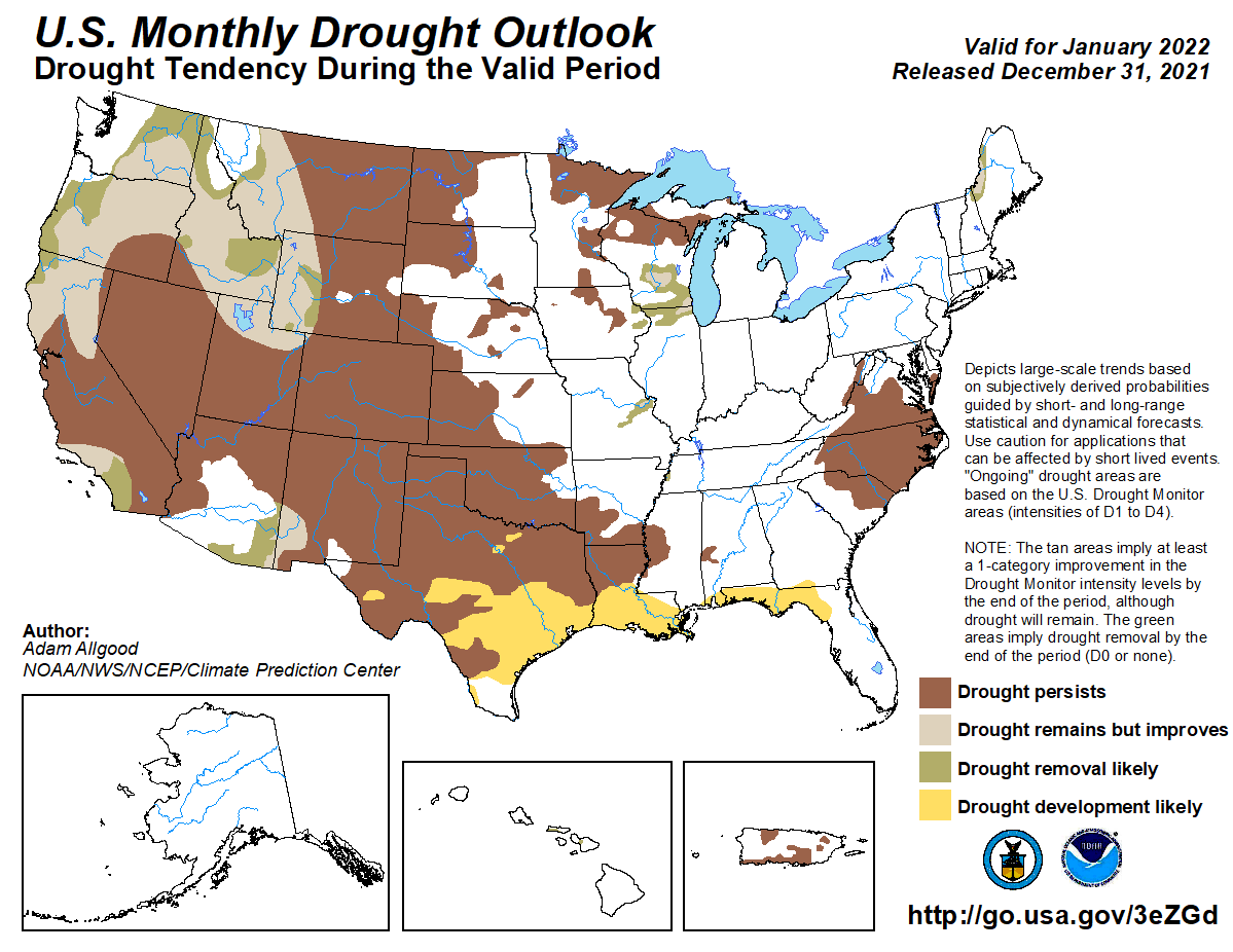
The latest outlook for January presents a pattern that continues to favor temperatures to be likely above normal over the southeast US and a precipitation pattern leaning below normal along the Gulf coast. It continues to remain abnormally dry over much of the local area. With the current long range outlook favoring below normal precipitation, forecasters will monitor for worsening dryness and a potential increase in drought development intensity over the deep south.
Click on the snap shots below to expand:
 January Normals January Normals |
|
Outlook |
|
|
Additional Climate Links:
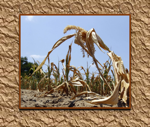
The links below are intended to provide additional climate information, education and outlooks. The National Weather Service Mobile Alabama's Climate and Past Weather page provides climate data at your fingertips for many observation points in the local forecast area by accessing the NOWData tab as well as many other climate resources. The Climate Prediction Center Link provides short and longer range climatic outlooks and education about the larger scale global circulations that impact temperatures and weather. With the large agriculture and farming presence along the central Gulf coast, the Drought Monitor link provides updates on drought trends and impacts. Another very helpful resource is the Community Collaborative Rain Hail and Snow (CoCoRaHS) network, which is a large group of volunteers working together to measure and map precipitation (rain, hail and snow). The aim of CoCoRaHS is to provide the highest quality data for natural resource, education and research applications. You can be a part of the CoCoRaHS team by becoming a volunteer rainfall observer. To learn more click on the CoCoRaHS link below.
National Weather Service Mobile AL Climate and Past Weather
Climate Prediction Center (CPC)
CoCoRaHS Network Water Year Summaries
![]()


