March 2023 Climate Summaries
Mobile Alabama and Pensacola Florida Area
National Weather Service Mobile Alabama
April 4, 2023
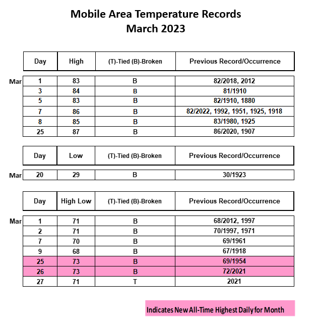
March 2023 in Review - Monthly temperatures for the third consecutive month of 2023 were above normal at both Mobile and Pensacola. There was an astounding number of daily temperature records set at both sites, 14 combined at Mobile and 10 at Pensacola. The most of these were new record high low temperatures, a few of which set new daily warmest lows. Mobile saw six record highs, seven record high lows, and one record low, while Pensacola saw three record highs, six record high low temperatures, and one record low. For high and low temperatures at Mobile, the longest stretch of warmth was the first 12 days of the month when daily highs averaged 11.0° above normal and daily lows averaged 13.3° above normal. For high and low temperatures at Pensacola, the longest stretch of warmth was also the first 12 days of the month when daily highs averaged 9.9° above normal and daily lows averaged 12.8° above normal. Not to be outdone though was a cold snap that impacted the deep south during the middle of the month, which is not uncommon for March in the deep south. A strong cold front made passage late on Sunday the 12th and a reinforcing cold front made passage Friday afternoon the 17th. From the 13th to the 21st, highs and lows went the other direction in comparison to the climatological means. Highs and lows averaged 6.7° and 10.9° below normal respectively through that period at Mobile. For the same time frame, highs and lows averaged 6.3° and 9.2° below normal respectively through the period at Pensacola. On the 20th, the thermometer plunged to freezing and a record setting crisp mid-March morning. To close out the month, highs and lows rebounded to mostly above normal.
For the third consecutive month of 2023, area rain gauges measured a shortage of monthly normal rainfall. Mobile was just shy of normal with Pensacola coming in short by over two inches.
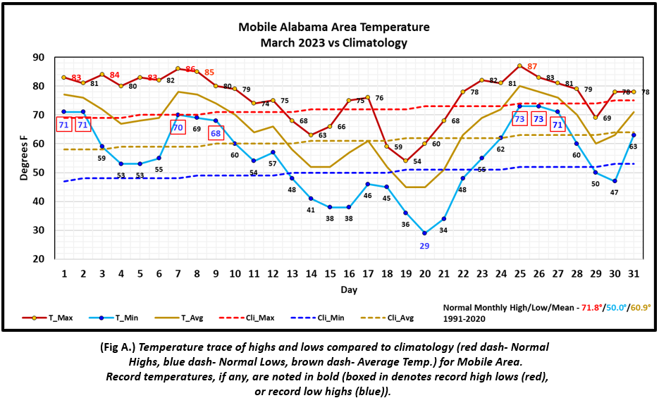
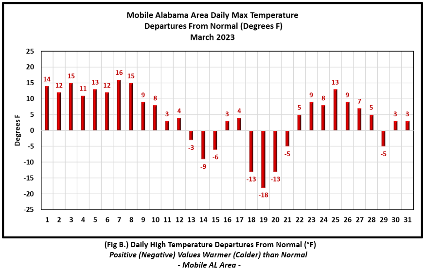
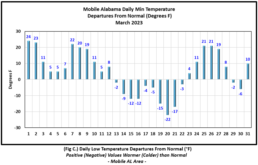
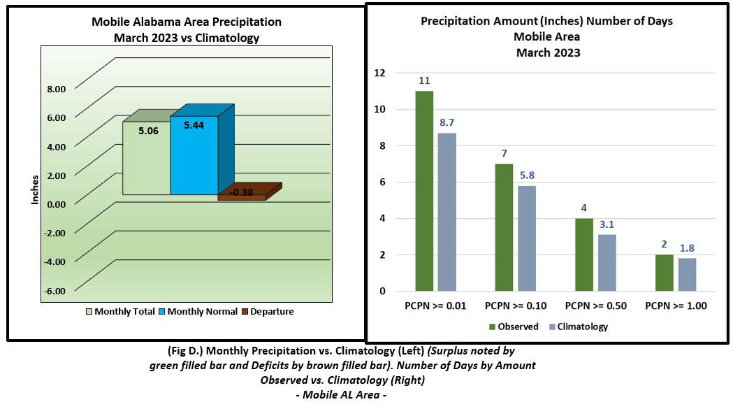
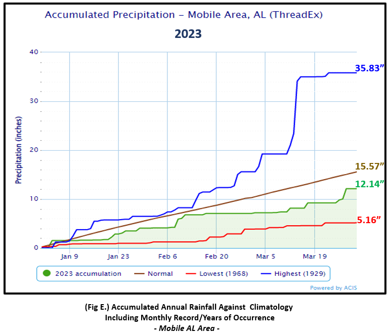
Mobile Alabama Area [Climate Normal Period 1991-2020, Climate Record Period 1872 to Present]- The average monthly high of 76.0° was 4.2° above normal. March 2023 was the 5th warmest March on record considering the average high. The average monthly low was 54.7° or 4.7° above normal. The average monthly temperature of 65.2° was 4.5° above normal. The highest temperature for the month, 87°, occurred on the 25th. In fact, this broke the previous record of 86° set back in 2020 and the other occurrence way back in 1907. It was also 13° above the normal for the date. The lowest temperature for the month plunged to a record setting 29° on the morning of the 20th, 22° below normal for this date. Due to the number of records set during the month of March, a complete listing is provided in table format below with the Mobile area climate graphs. (Fig. A) shows a graphical representation of how the Mobile Area temperatures compared to the seasonal normal daily highs and lows, which are shown by the colored dashed lines. Bar graphs reflecting the daily high/low temperature departures from normal are provided in the table below (Figs. B and C). The rain gauge collected 5.06" (Fig. D), or 0.38" below normal. Accumulated rainfall climatology is in a deficit by nearly 3.5" for Mobile thus far at the close of March (Fig. E). Click to view Mobile's March Weather Summary text product from the NWS Mobile.
March Top Records for the Month During the Period of Record for the Mobile Area:
Click on the Mobile Alabama area climate graphics below to expand:
|
|
|
|
|
|
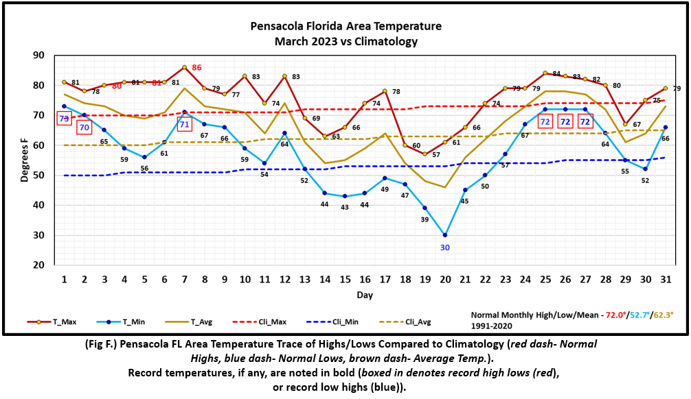
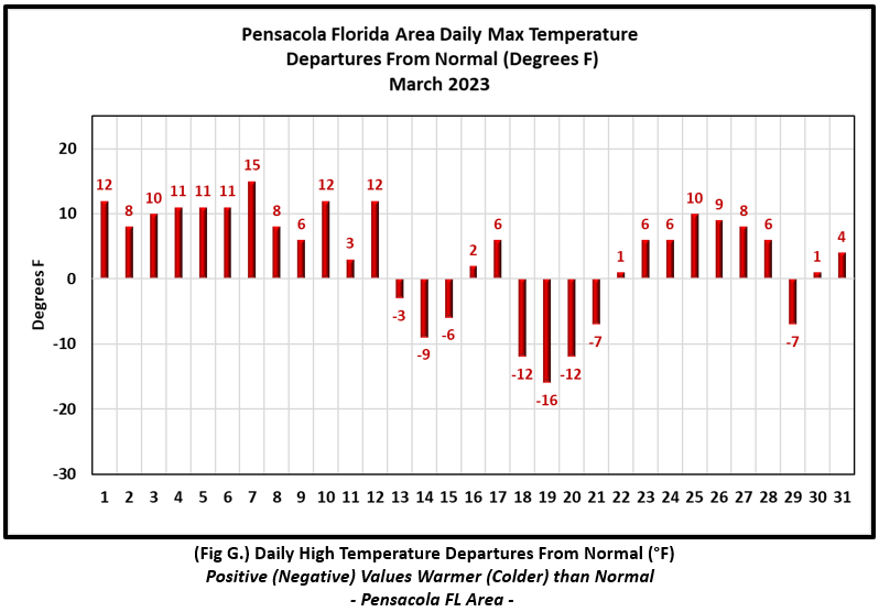
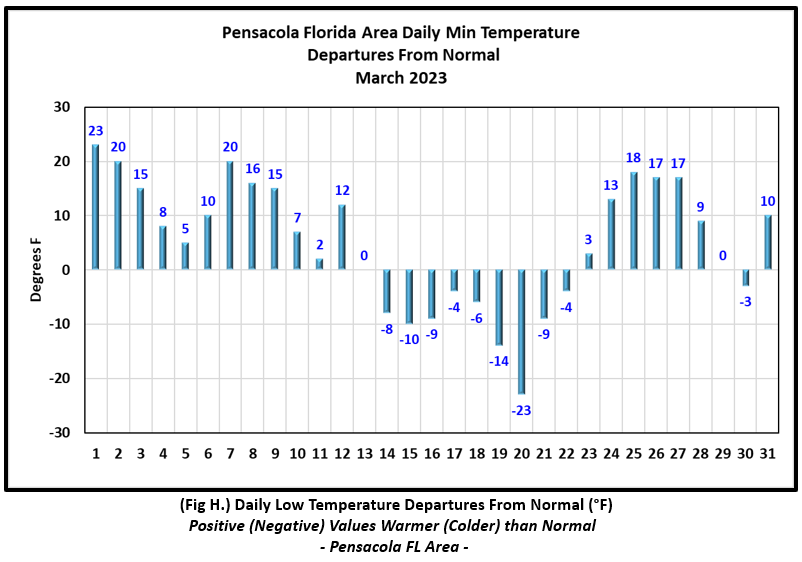
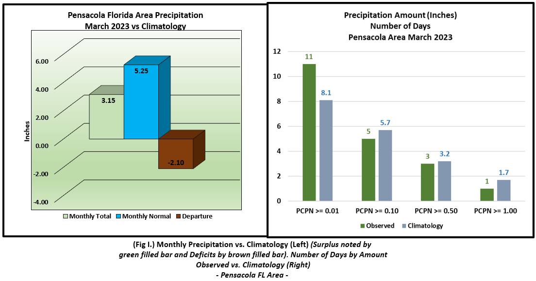
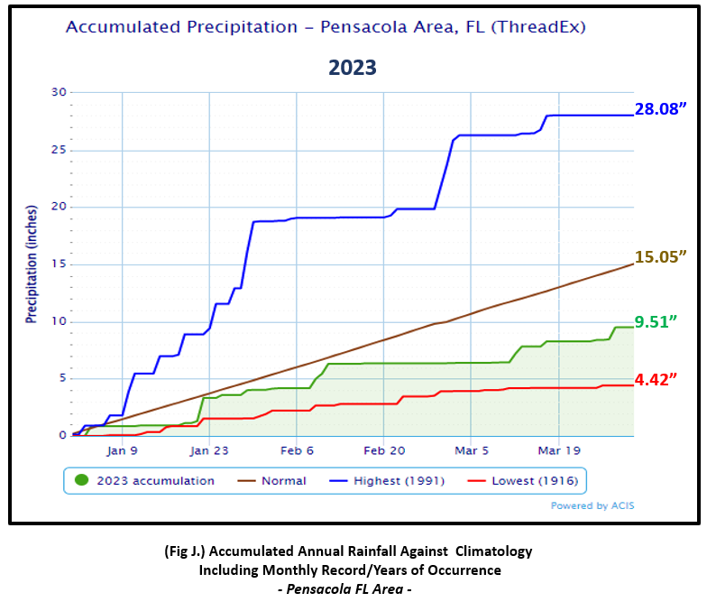
Pensacola Florida Area [Climate Normal Period 1991-2020, Climate Record Period 1879 to Present] - The average monthly high of 75.5° was 3.5° above normal. March 2023 was the 5th warmest March on record considering the average high. The average monthly low of 57.6° was 4.9° above normal. The average monthly temperature of 66.5° was 4.2° above normal and 5th warmest average March temperature on record. The highest temperature for the month, 86°, occurred on the 7th. This smashed the previous record of 83° set back in 1992 and was 15° above the normal for the date. The lowest temperature for the month dipped to 30° on the morning of the 20th which tied the previous record on this date set back in 1923 and was 23° below normal for this date. Due to the number of records set during the month of March, a complete listing is provided in table format below with the Pensacola Area climate graphs. (Fig. F) shows a graphical representation of how the Pensacola area temperatures compared to the seasonal normal daily highs and lows, which are shown by the colored dashed lines. (Figs. G and H) shows the daily high/low temperature departures from normal. The rain gauge collected 3.15" (Fig. I), or 2.10" below normal. Accumulated rainfall climatology remains in deficit by nearly 5.5" for Pensacola thus far at the close of March (Fig. J). Click to view Pensacola's March Weather Summary text product from the NWS Mobile.
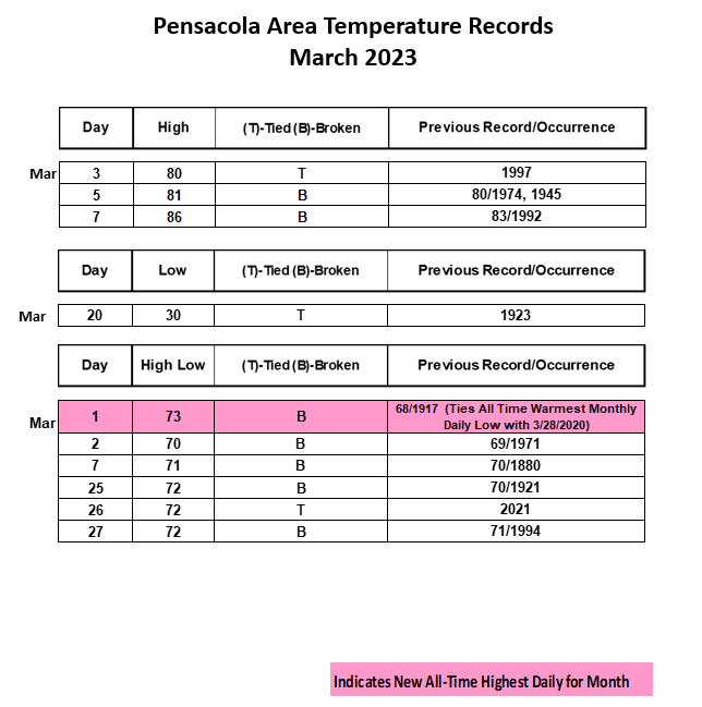
March Top Records for the Month During the Period of Record for the Pensacola Area:
Click on the Pensacola Florida area climate graphics below to expand:
|
|
|
|
|
|
Additional March 2023 Climatology and Topics
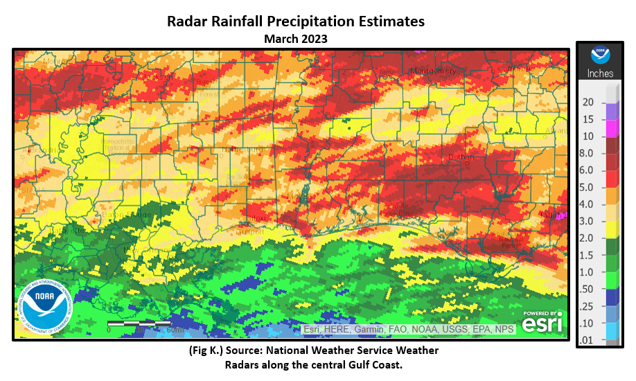
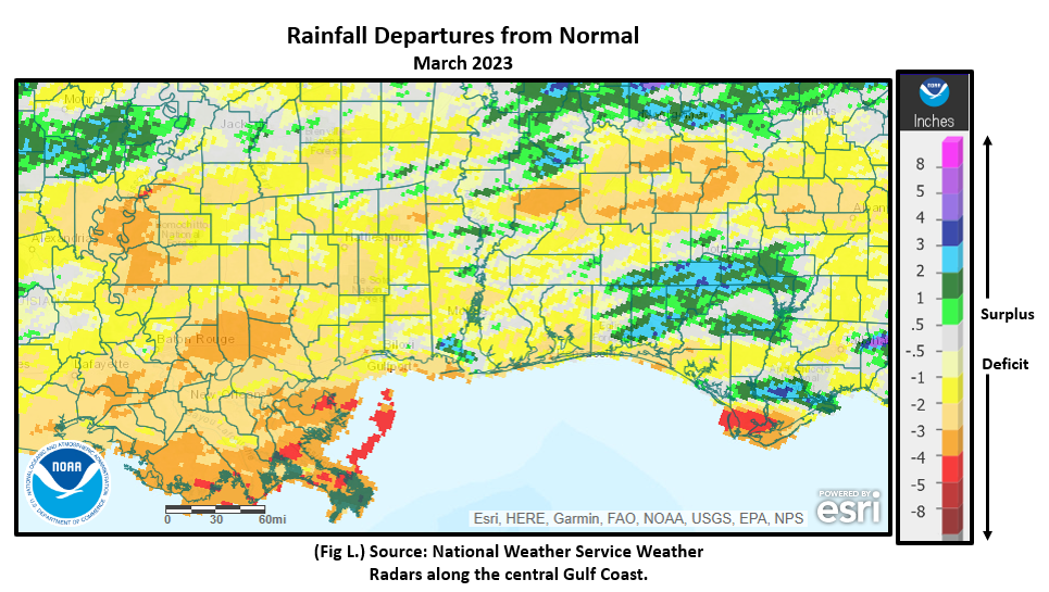
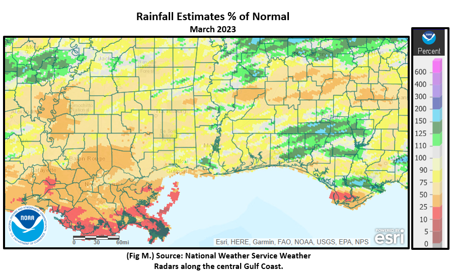
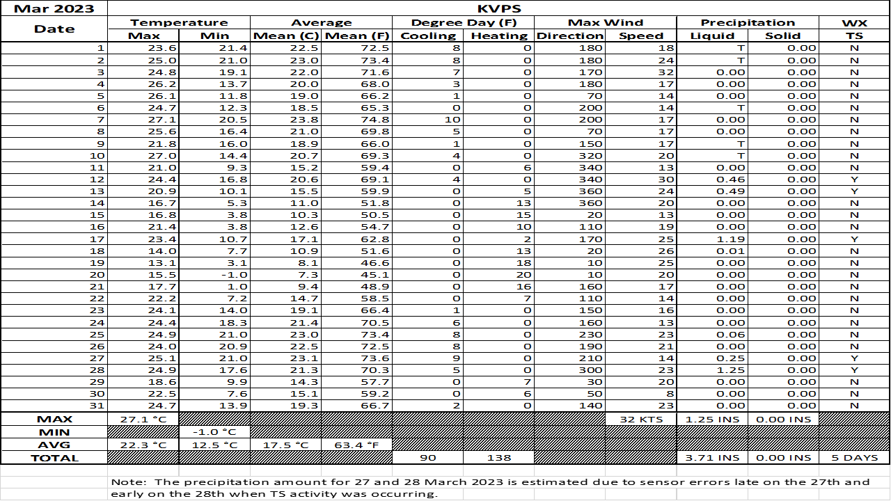
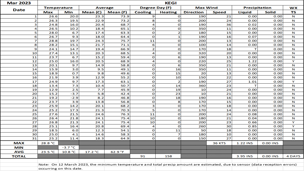
The higher rainfall totals for the month was more focused primarily between the I-10 corridor and south of US Highway 84. Despite this, only isolated areas within the rainfall maximum received above 110% of normal rainfall. Fig. K shows the areal monthly rainfall total, Fig. L shows the areal rainfall departures from normal and Fig. M, the areal percent of normal rainfall. The latest March 2023 monthly summary for Eglin Air Force Base (AFB) - KVPS and Duke Field - KEGI has been received and provided in the table below. The temperatures in the daily tables consists of numbers both in °F/°C. Data courtesy of Mr. David Biggar, Staff Meteorologist, 96th Weather Squadron. Provided by permission.
|
|
|
|
|
|
April 2023 Climatology, Seasonal Climatology and Outlooks:
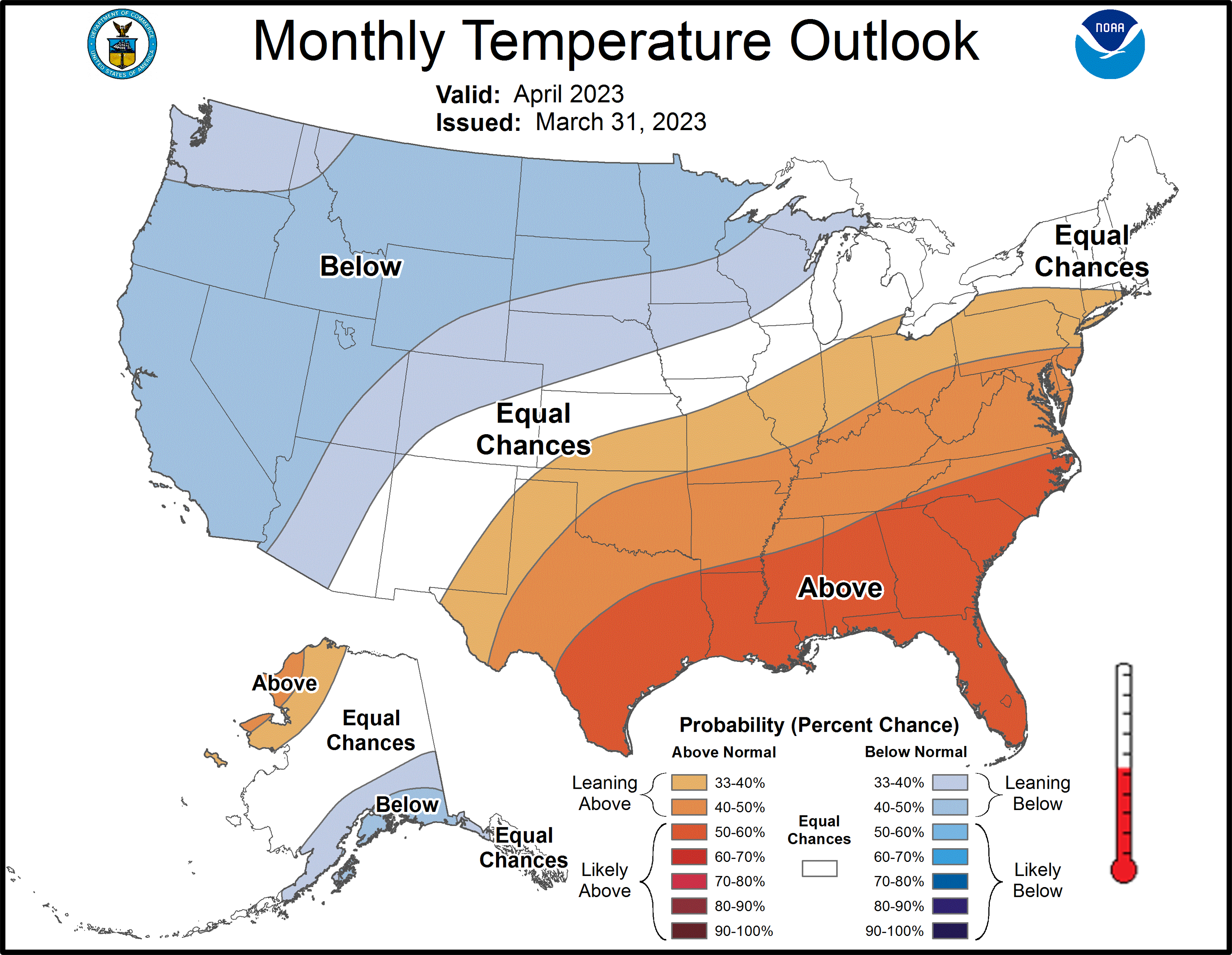
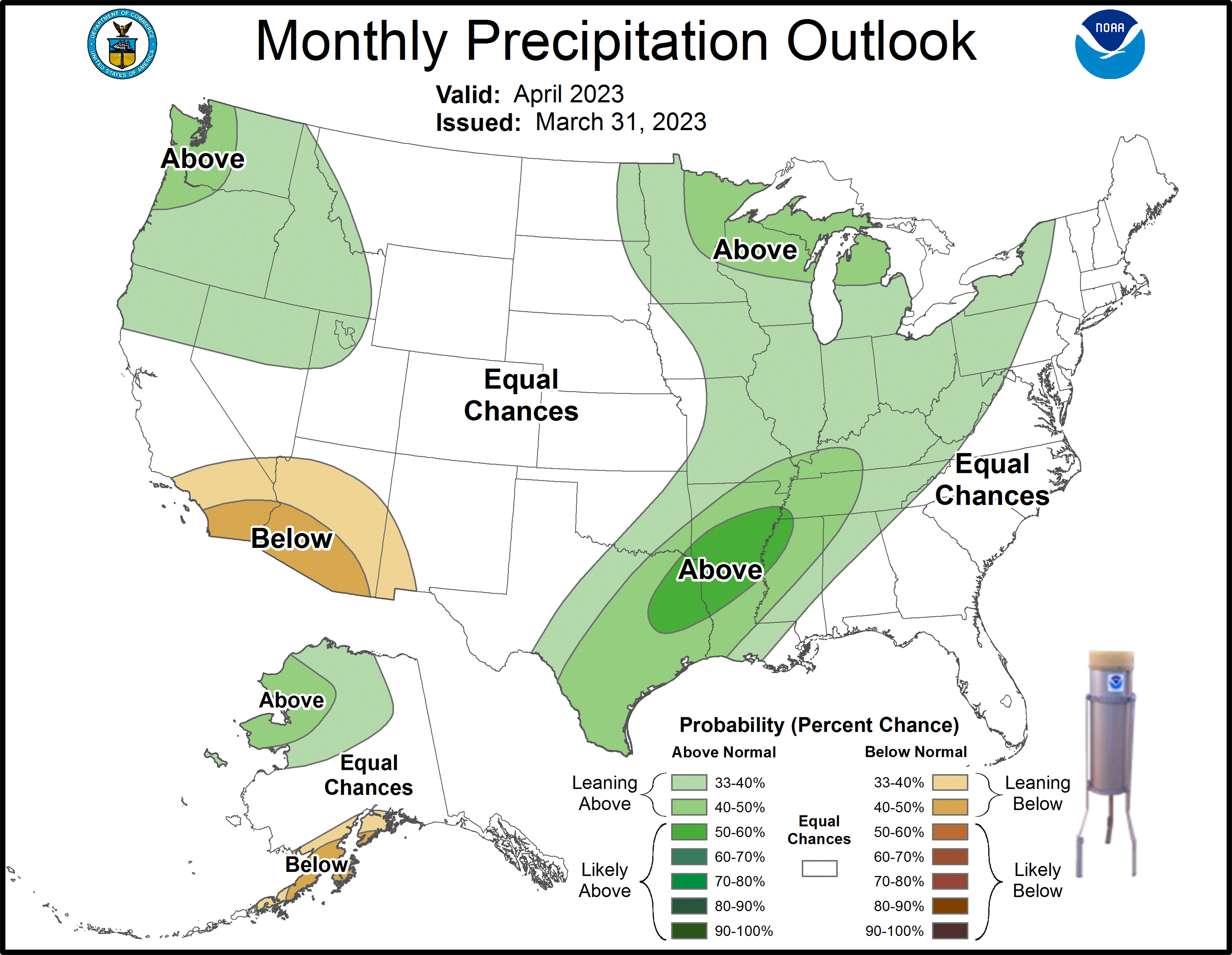
The trend of experiencing above normal monthly warmth is favored as we move into the heart of Spring. The latest outlook for April favors temperatures being likely above normal over the southeast with above normal precipitation favored to be concentrated over the Lower MS River Delta. Local recreational and commercial growers will need to stay vigilant though to ensure spring crops have sufficient watering as weather systems can be fickle and a routine of watering from these cannot be expected. We can also experience cold snaps with occasional freezing temperatures in April with some of the record latest occurrences occurring over the interior through middle to late April. Click on the snap shots below to expand:
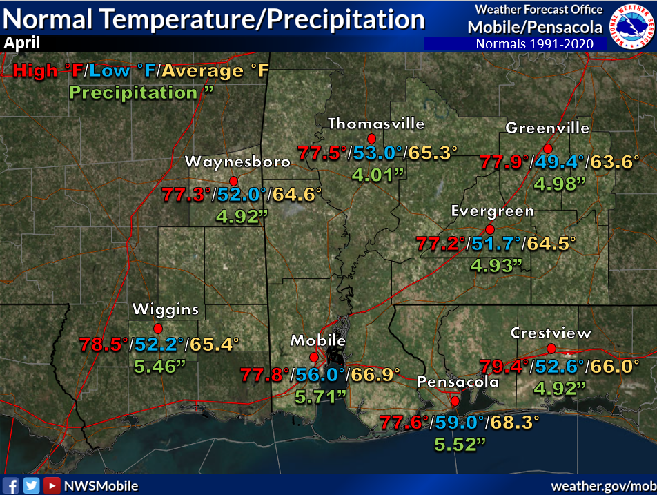 April Normals April Normals |
|
Outlook |
|
Additional Climate Links:
The links below are intended to provide additional climate information, education and outlooks. The National Weather Service Mobile Alabama's Climate and Past Weather page provides climate data at your fingertips for many observation points in the local forecast area by accessing the NOWData tab as well as many other climate resources. The Climate Prediction Center Link provides short and longer range climatic outlooks and education about the larger scale global circulations that impact temperatures and weather. With the large agriculture and farming presence along the central Gulf coast, the Drought Monitor link provides updates on drought trends and impacts. Another very helpful resource is the Community Collaborative Rain Hail and Snow (CoCoRaHS) network, which is a large group of volunteers working together to measure and map precipitation (rain, hail and snow). The aim of CoCoRaHS is to provide the highest quality data for natural resource, education and research applications. You can be a part of the CoCoRaHS team by becoming a volunteer rainfall observer. To learn more click on the CoCoRaHS link below.
National Weather Service Mobile AL Climate and Past Weather
Climate Prediction Center (CPC)
CoCoRaHS Network Water Year Summaries
![]()


