October 2023 Climate Summaries
Mobile Alabama and Pensacola Florida Area
National Weather Service Mobile Alabama
November 1, 2023
October 2023 in Review - The top story in the weather news for the Gulf coast is persistent severe to extreme drought intensity. More on this soon to follow. High, low and monthly mean temperatures were close to October normals. Despite this, there were periods of large temperature swings about the means. Heading into the middle of the month, the central Gulf coast saw the first taste of Fall following the passage of a couple of strong cold fronts. From the 11th to the 17th, the Mobile area high temperatures averaged 7.5° below normal and the lows from the 7th to the 19th averaged 6.4° below normal. Following the cool down, temperatures recovered to well above normal at Mobile seeing the largest departures in highs from the 20th to the 30th, averaging 8.6° above normal. At Pensacola, high temperatures averaged 6.6° below normal from the 8th to the 18th and lows from the 7th to the 19th averaged 6.2° below normal. Following the cool down, temperatures recovered to well above normal at Pensacola on average. Halloween Day saw yet another cool off to temperatures, sinking back below normal with the passage of a potent cold front.
Severe to extreme drought maintained a firm grip over the central Gulf coast as rainfall deficits continued to rise. Although October is one of our typically drier months, rainfall for the month fell far short of typically normal October rainfall amounts. Year to date rainfall deficits have increased to near 11" and 8" below normal for the Mobile and Pensacola areas respectively at the close of October.
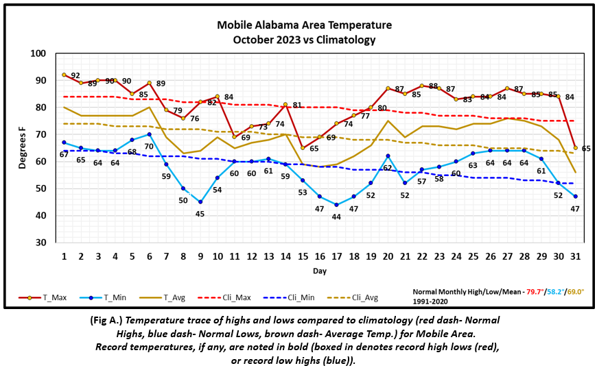
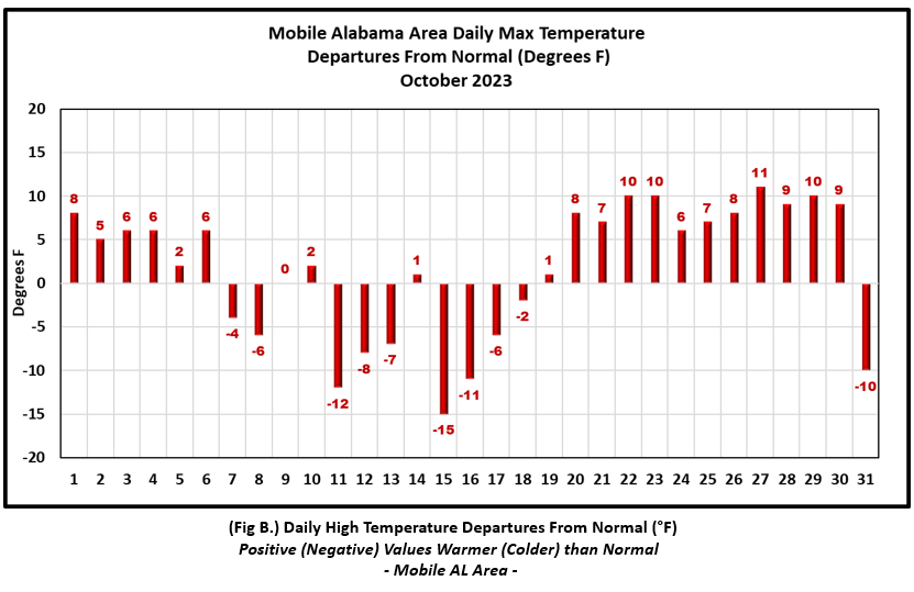
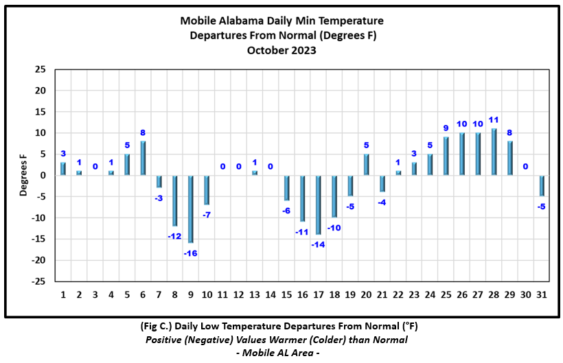
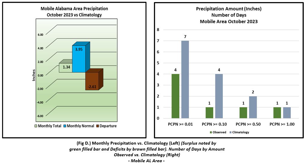
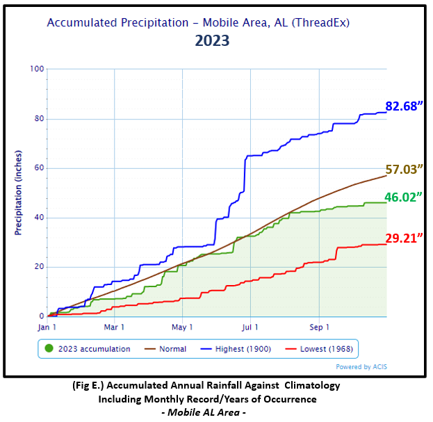
Mobile Alabama Area [Climate Normal Period 1991-2020, Climate Record Period 1872 to Present]- The average monthly high of 81.4° was 1.7° above normal. The average monthly low was 57.8° or 0.4° below normal. The average monthly temperature of 69.6° was 0.6° above normal. The highest temperature for the month was 92° on the 1st or 8° above the normal for the date. The lowest temperature for the month was a chilly 44° on the morning of the 17th, or 14.0° below normal for this date. No new record temperatures were reached for the month. (Fig. A) shows a graphical representation of how the Mobile area temperatures compared to the seasonal normal daily highs and lows, which are shown by the colored dashed lines. Bar graphs reflecting the daily high/low temperature departures from normal are provided in the table below (Figs. B and C). Rain was sorely lacking and well shy of the monthly normal. The monthly total gauge catch was a meager 1.34" (Fig. D) or 2.61" below the monthly normal. Annual rainfall continued to show a swelling deficit to now 11.01" below normal for the Mobile area. (Fig. E)
October top records for the month during the Period of Record for the Mobile Area:
Click on the Mobile Alabama area climate graphics below to expand:
|
|
|
|
|
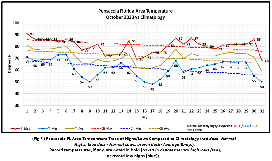
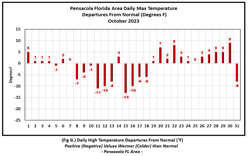
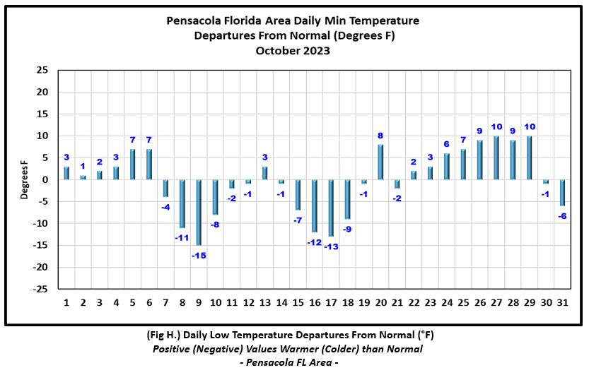
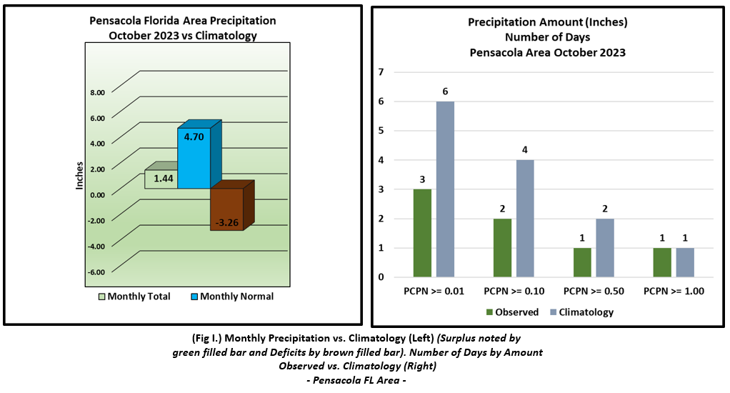
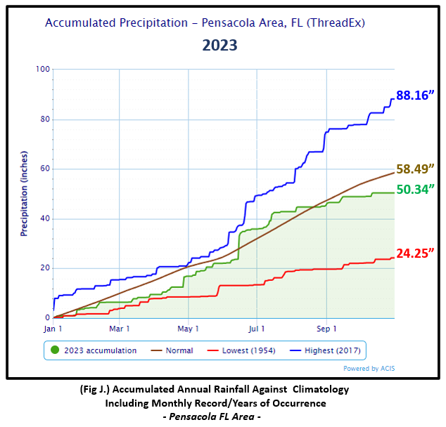
Pensacola Florida Area [Climate Normal Period 1991-2020, Climate Record Period 1879 to Present] - The average monthly high of 80.4° was 0.7° below normal. The average monthly low was 61.6° was normal. The average monthly temperature of 71.0° was 0.3° below normal. The highest temperature for the month was 91° on the 1st, 5° above the normal daily high temperature for the date. The lowest temperature for the month was a cool, 48° on the 17th, 13° below the normal daily low temperature for this date. No new record temperatures were reached at Pensacola. (Fig. F) shows a graphical representation of how the Pensacola area temperatures compared to the seasonal normal daily highs and lows, which are shown by the colored dashed lines. (Figs. G and H) shows the daily high/low temperature departures from normal. Monthly rain was greatly lacking with a gauge catch totaling only 1.44" (Fig. I), or 3.26" below the monthly normal. The deficit in annual rainfall at Pensacola continued to increase to now 8.15" below normal. (Fig. J).
October top records for the month during the Period of Record for the Pensacola Area:
Click on the Pensacola Florida area climate graphics below to expand:
|
|
|
|
|
Additional October 2023 Climatology and Topics
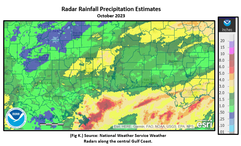
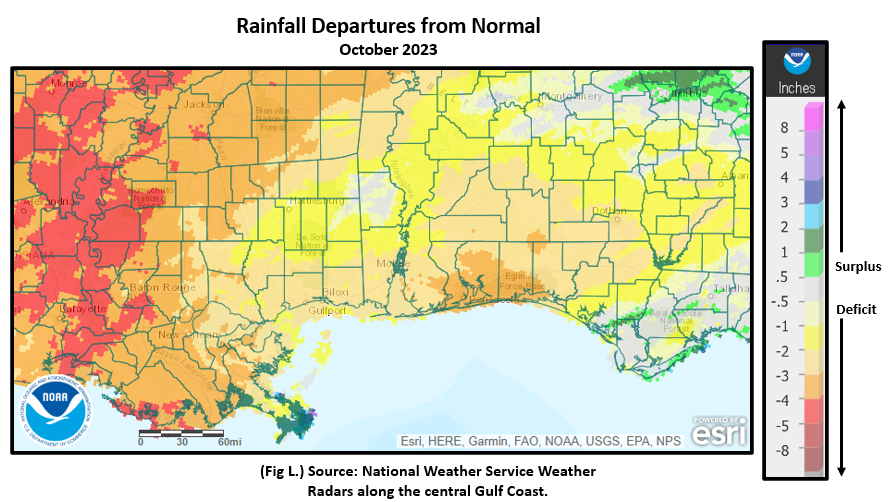
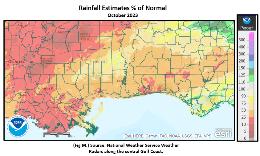
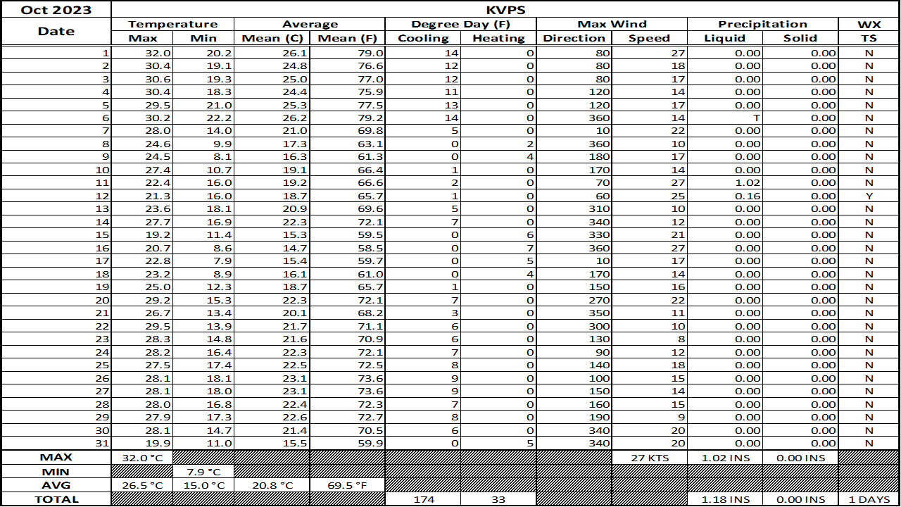
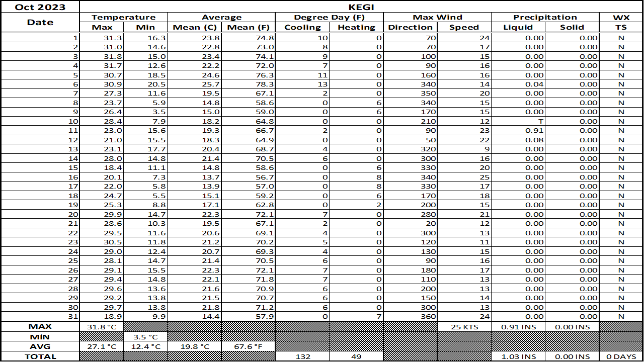
A substantial lack in precipitation over a short term, three month span from August to October across the coastal plain caused drought intensity to worsen to severe to extreme levels through the period. There was a small area from interior southeast Mississippi into portions of extreme southwest Alabama that saw between two and four inches of monthly rain. Elsewhere, not so much. The driest of areas, mainly along and southeast of I-65 saw monthly rainfall deficits from two to four inches below monthly normal or 10 to 50% of normal. Fig. K shows the areal monthly rainfall total, Fig. L shows the areal rainfall departures from normal and Fig. M, the areal percent of normal rainfall. The October 2023 monthly summary for Eglin Air Force Base (AFB) - KVPS and Duke Field - KEGI has also been received and provided in the table below. The temperatures in the daily tables consists of numbers both in °F/°C. Data courtesy of Mr. David Biggar, Staff Meteorologist, 96th Weather Squadron. Provided by permission.
|
|
|
|
|
|
November 2023 Climatology, Seasonal Climatology and Outlooks:
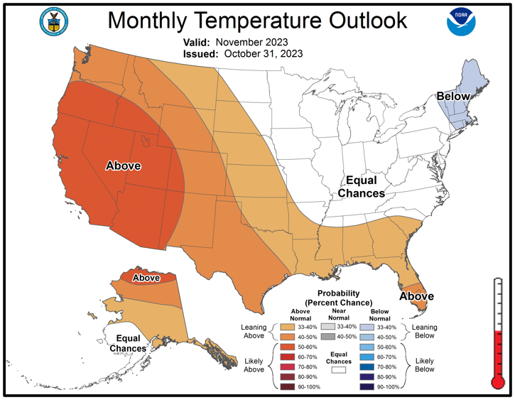
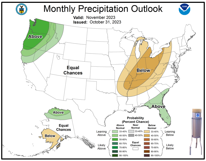
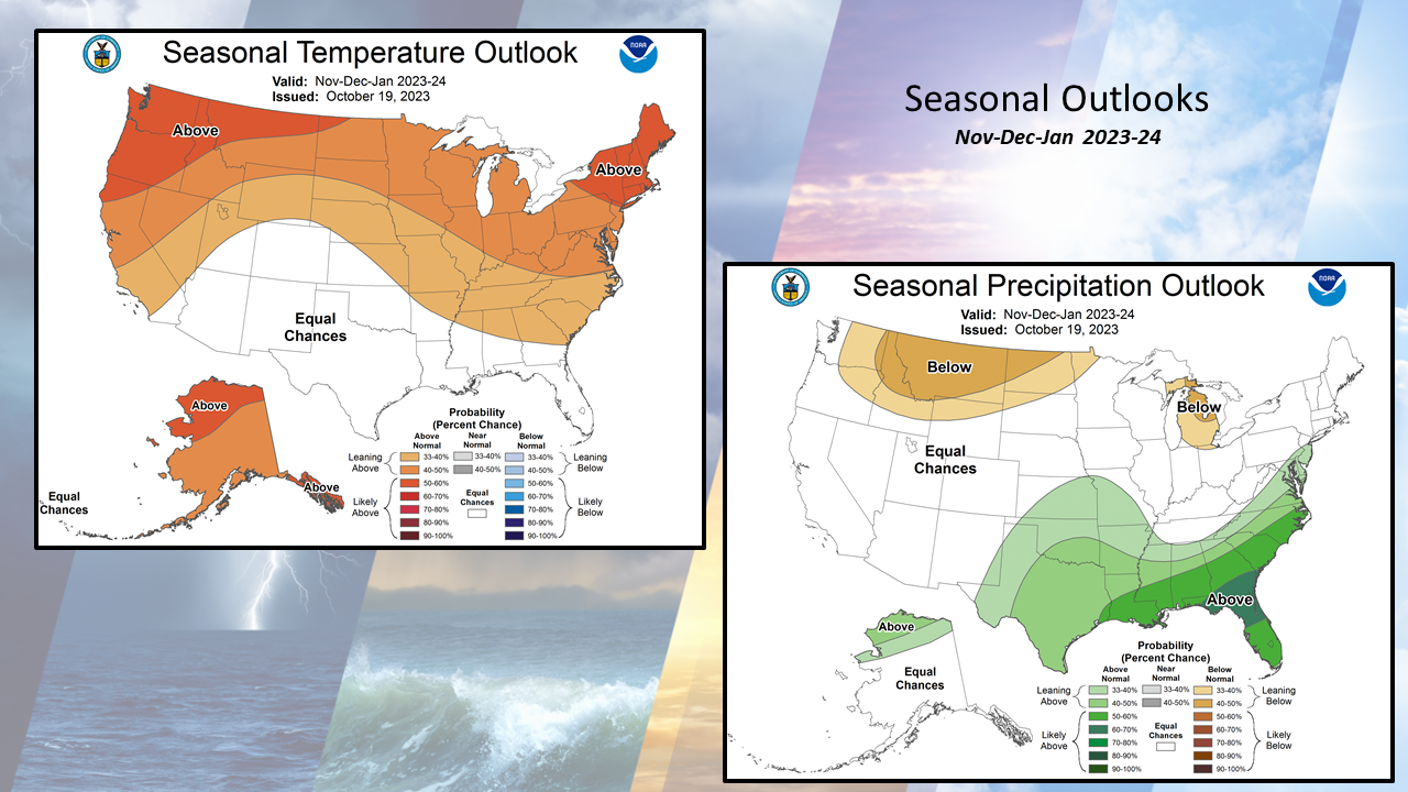
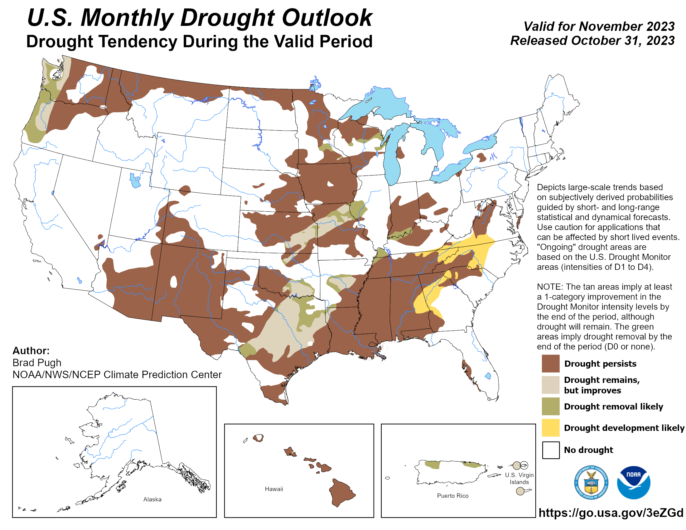
Looking ahead to November, the deep south is favored to see temperatures leaning above normal. The southeast may see above normal precipitation while the coastal plain is favored to see equal chances of above or below normal rainfall. With strong El Niño in place, there are indications that the southern branch of the jet-stream will become more active over the next few months which would tend to favor a more active, potentially wet winter over the deep south. This would suggest that drought conditions could ease or improve. In the near term, the highest local drought impacts continue to focus on agriculture with poor to very poor crop condition, widespread crop disease, insect damage and stress on livestock. Please visit the National Integrated Drought Information System (NIDIS) for the latest updates on local and regional drought statements, impacts and outlooks. NOAA issued its Winter Weather Outlook October 19th.
Click on the snap shots below to expand:
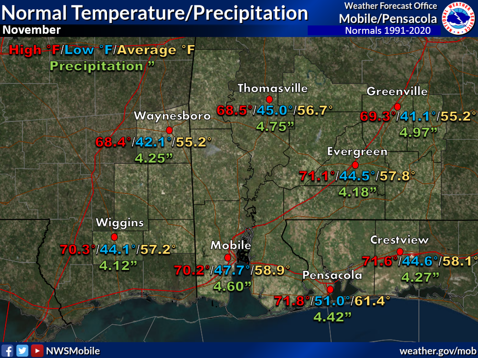 November Normals November Normals |
|
Outlook |
|
|
|
Additional Climate Links:
The National Weather Service Mobile Alabama's Climate and Past Weather page provides climate data at your fingertips for many observation points in the local forecast area by accessing the NOWData tab as well as many other climate resources. The Climate Prediction Center Link provides short and longer range climatic outlooks and education about the larger scale global circulations that impact temperatures and weather. With the large agriculture and farming presence along the central Gulf coast, the Drought Monitor link provides updates on drought trends and impacts. Another very helpful resource is the Community Collaborative Rain Hail and Snow (CoCoRaHS) network, which is a large group of volunteers working together to measure and map precipitation (rain, hail and snow). The aim of CoCoRaHS is to provide the highest quality data for natural resource, education and research applications. You can be a part of the CoCoRaHS team by becoming a volunteer rainfall observer.


