October 2026 Climate Summaries
Mobile Alabama and Pensacola Florida Area
National Weather Service Mobile Alabama
November 1, 2026
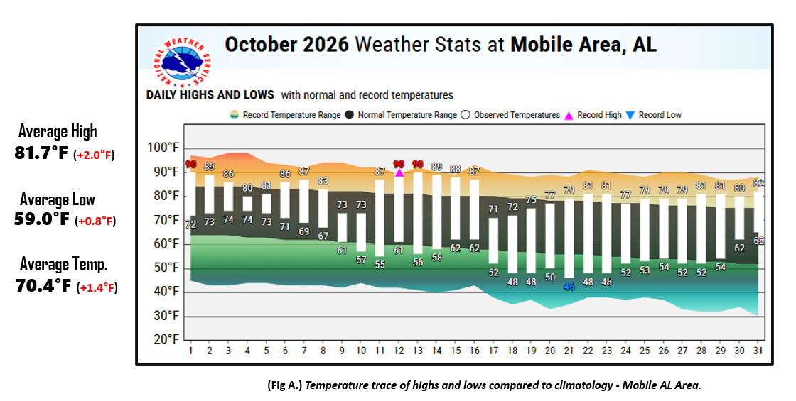
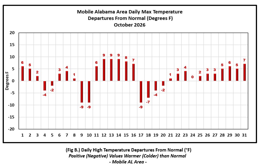
October 2026 in Review - High temperatures for the month of October averaged a couple degrees above normal at Mobile while Pensacola's was just a hair below normal. The warmest high temperature duration about the means was from the 11th to the 16th at both locations when highs averaged 8.0° above normal at Mobile; during this period, Mobile set a new record high on the 12th. For the same period, highs averaged 5.2° above normal at Pensacola for the period. Hurricane Isaias bottomed out the daily highs to the mid 70's for the 9th and 10th, averaging 9.0° below normal on these two days at both Mobile and Pensacola. Following the passage of the first strong cold front through the region later in the day on the 16th, highs dropped 13 to 16° in a day's time and well below mid October normal by the 17th. Highs then moderated to above normal to close out the month.
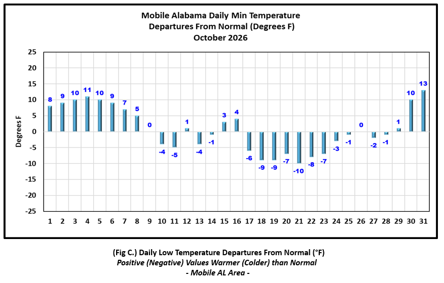
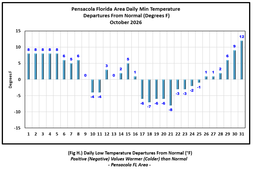
Lows started off on the warm side the first eight days of the month averaging 8.6° above normal at Mobile and 7.1° above normal at Pensacola through this period. A touch of Fall followed the mid month cold front with lows dipping down to 7.4° below normal on average at Mobile and 5.1° below normal on average at Pensacola from the 17th to the 24th. As with the highs, lows also moderated the remainder of the month and warmed to above normal by the end of October. No record lows were set and Mobile and Pensacola.
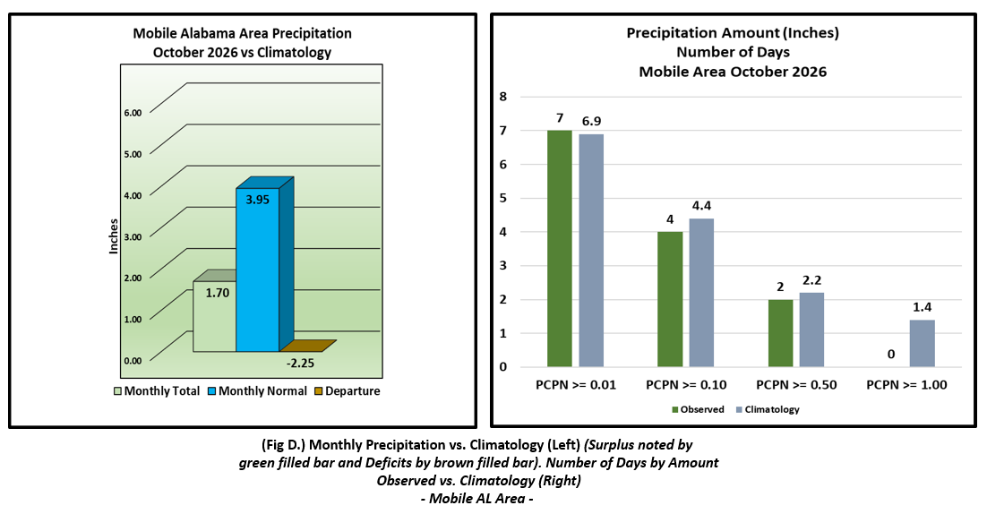
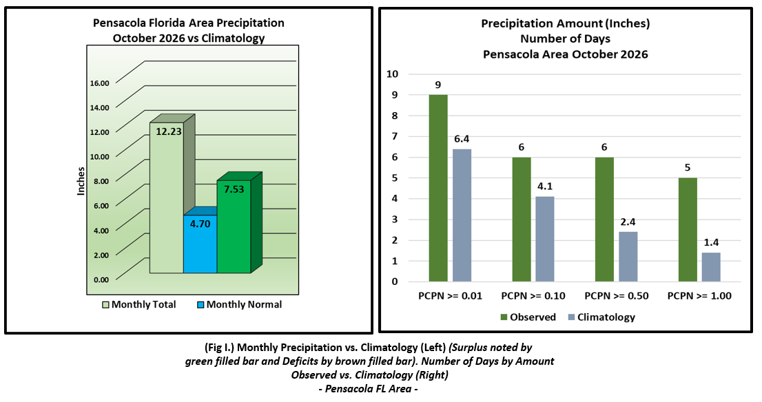
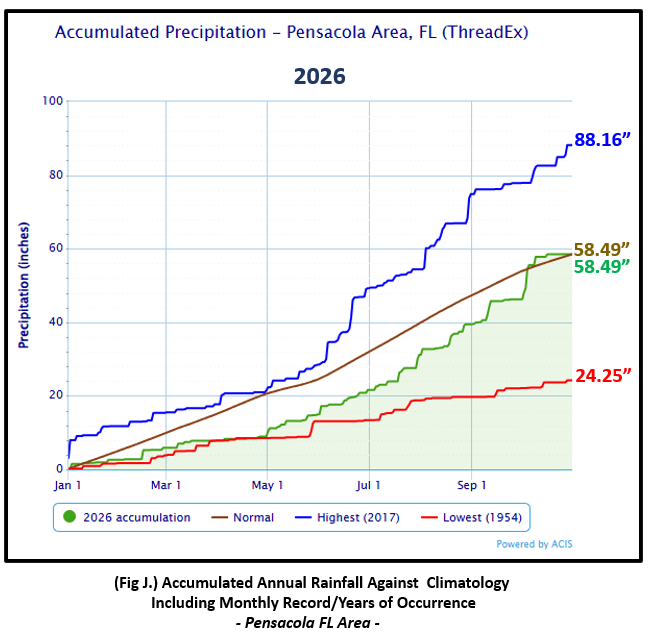
Precipitation was vastly different between Mobile and Pensacola. Mobile did not see two inches of rain for the month while the rain gauge collected over a foot of rain at Pensacola. The rainfall deficits increased at Mobile to over a half foot below normal to date. On the flip side, Pensacola is right on top of normal to date.
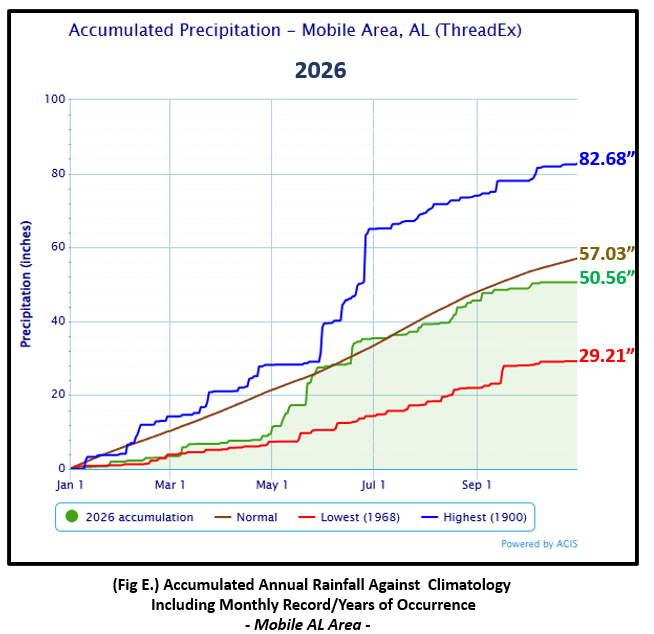
Mobile Alabama Area [Climate Normal Period 1991-2020, Climate Record Period 1872 to Present]- The average monthly high of 81.7° was 2.0° above normal. The average monthly low of 59.0° was 0.8° above normal. The average monthly temperature of 70.4° was 1.4° above normal. The highest temperature for the month was a warm 90° by October standards occurring on three days the 1st, the 12th, and the 13th. This was 6° above normal for 1st and 9° above normal on the 12th and 13th. 90° on the 12th set a new record daily high, breaking the previous occurrence on this date of 89° set back in 2009, 1991, 1970, and 1954. The lowest temperature for the month was a cool 46° on the 21st and 10.0° below normal for the date. (Fig. A) shows a bar graphical representation of how the Mobile area daily temperatures compared to the seasonal normal daily highs and lows. Bar graphs reflecting the daily high/low temperature departures from normal are provided in the table below (Figs. B and C). With October a typically dry month, Mobile was very dry and shy by over two inches from the normal. The monthly total gauge catch was 1.70" (Fig. D) or 2.25" below the monthly normal. Annual rainfall has increased to 6.47" below normal to date for the Mobile area. (Fig. E)
October top records for the month during the Period of Record for the Mobile Area:
Click on the Mobile Alabama area climate graphics below to expand:
|
|
|
|
|
Pensacola Florida Area [Climate Normal Period 1991-2020, Climate Record Period 1879 to Present] - The average monthly high of 80.9° was 0.2° below normal. The average monthly low of 63.3° was 1.7° above normal. The average monthly temperature of 72.1° was 0.8° above normal. The highest temperature for the month was 90° on the 12th, 8° above the normal daily high temperature for the date. The lowest temperature for the month was 52° on morning of the 21st, 8° below the normal daily low temperature for this date. No new record temperatures were reached at Pensacola. (Fig. F) shows a bar graphical representation of how the Pensacola area daily temperatures compared to the seasonal normal daily highs and lows. (Figs. G and H) shows the daily high/low temperature departures from normal. Pensacola's rain gauge captured 12.23" (Fig. I), or 7.53" above the monthly normal. Remarkably, Pensacola is right on top of normal annual rainfall to date at 58.49". (Fig. J).
October top records for the month during the Period of Record for the Pensacola Area:
Click on the Pensacola Florida area climate graphics below to expand:

|

|
|
|
|
Additional October 2026 Climatology and Topics
The highest rainfall amounts for the month was focused east of the I-65 corridor, southward to the northwest Florida Panhandle. Portions of these areas saw 4 to 8+ inches above October normal rainfall equating to a staggering 300 to 600% of monthly normal rains. (Fig. K) shows the areal monthly rainfall total, (Fig. L) shows the areal rainfall departures from normal and (Fig. M), the areal percent of normal rainfall. Much of the remainder of the area was short of monthly normal rainfall. Areal coverage of drought did shrink through the month. Despite this, pockets of severe drought held on in portions of interior southwest Alabama and interior southeast Mississippi (Fig. N). The Atlantic Basin saw two named storms. Hurricane Isaias developed over the Gulf late in the evening October 7th and stands at the top of the list in latest first hurricanes to develop since the Satellite era. Subtropical Storm Josephine formed over the western Atlantic October 21st (Fig. O), Considering these storms, a total of ten named storms have formed in the Atlantic Basin for 2026, which verifies to date the expectation of below normal activity in the Atlantic Basin thus far.
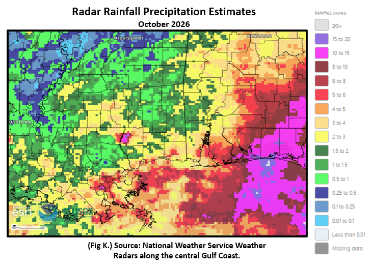 Figure K. |
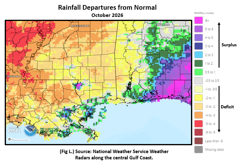 Figure L. |
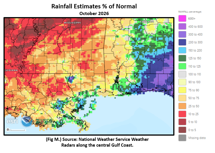 Figure M. |
 Figure N. |
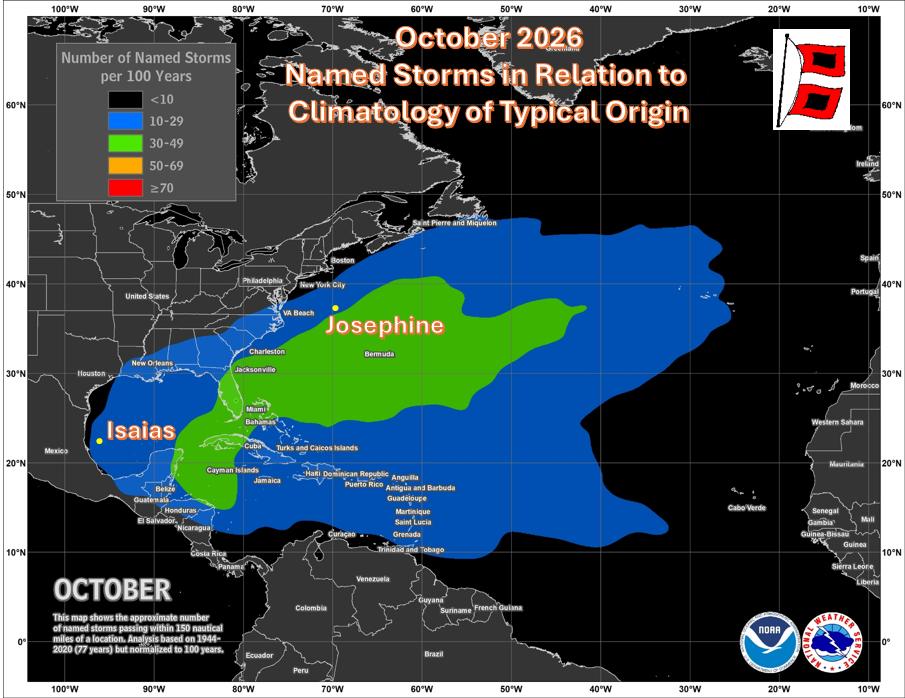
|
November 2026 Climatology, Seasonal Climatology and Outlooks:
Looking ahead to November, the deep south is favored to see temperatures leaning above normal while precipitation is favored to lean above normal. Entering the cold season, there are equal chances of above to below normal temperatures while precipitation is favored to be likely above normal. Lingering drought is expected to improve or end entirely by the end of November. Please visit the National Integrated Drought Information System (NIDIS) for the latest updates on local and regional drought statements, impacts and outlooks.
Click on the snap shots below to expand:
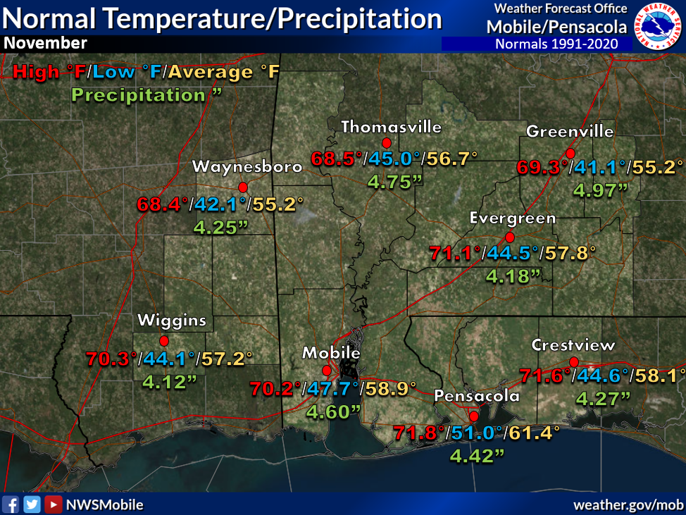 November Normals |

|
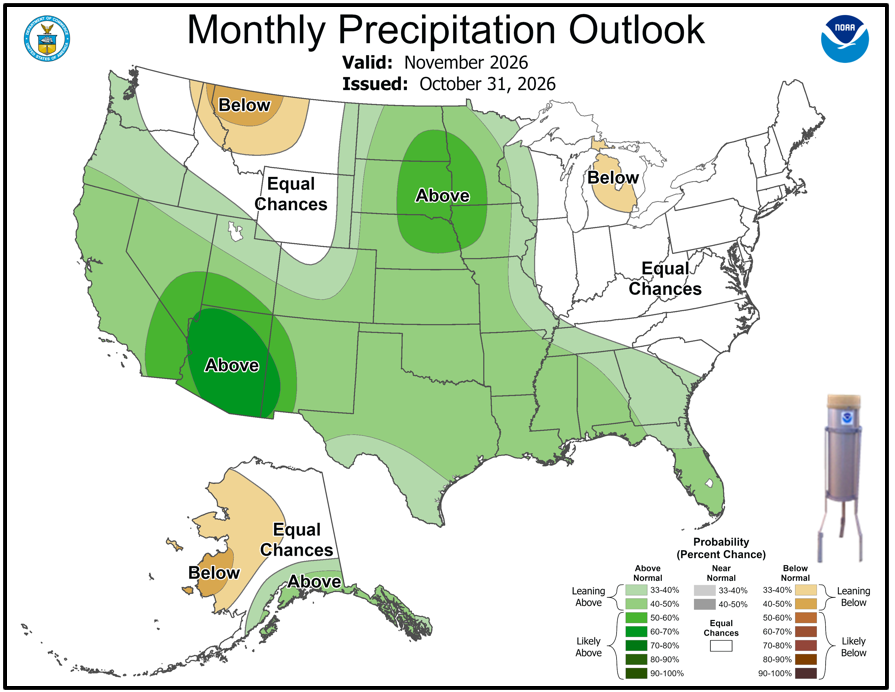
Outlook |

|

|
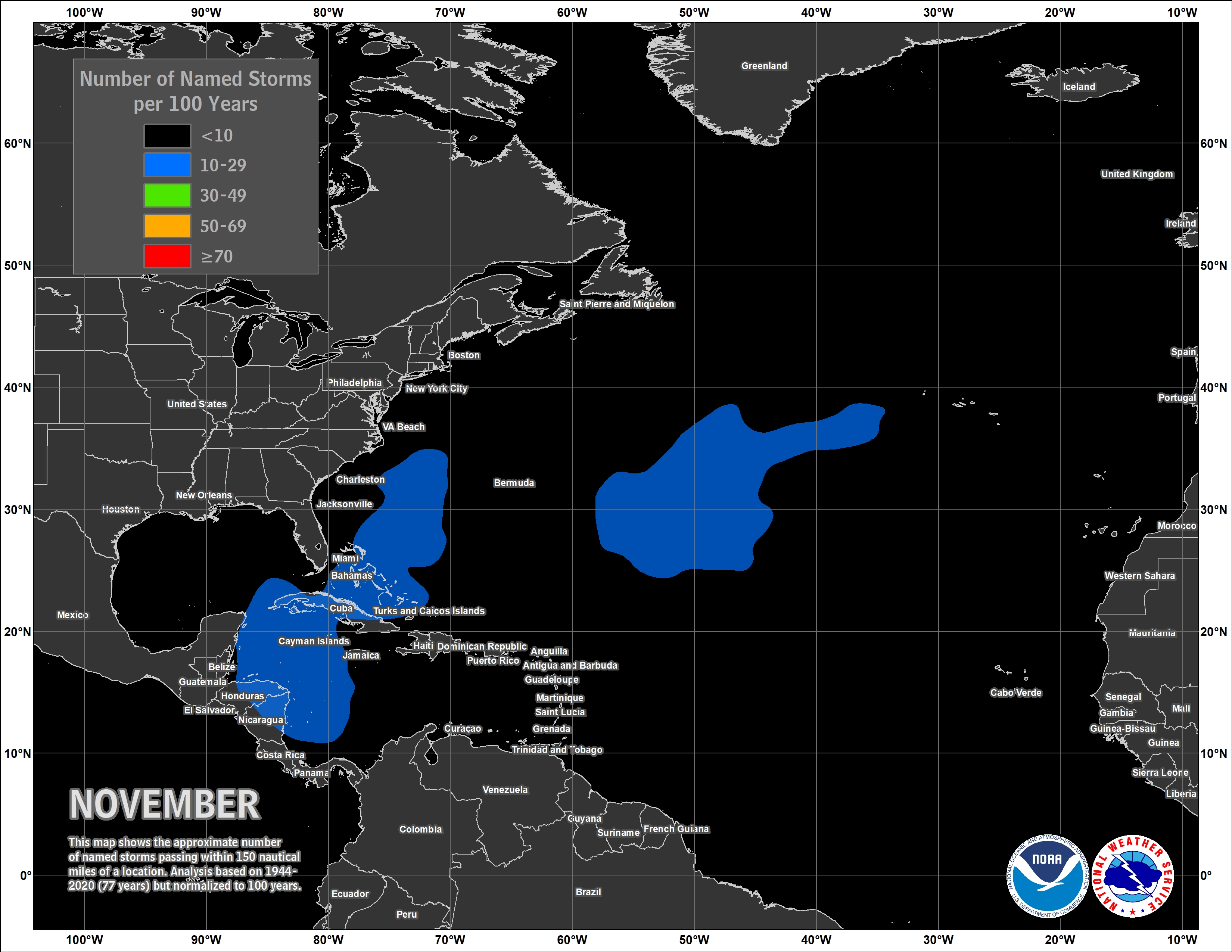
|
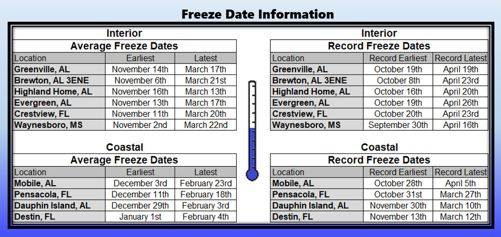
|
Additional Climate Links:
The National Weather Service Mobile Alabama's Climate and Past Weather page provides climate data at your fingertips for many observation points in the local forecast area by accessing the NOWData tab as well as many other climate resources. The Climate Prediction Center Link provides short and longer range climatic outlooks and education about the larger scale global circulations that impact temperatures and weather. With the large agriculture and farming presence along the central Gulf coast, the Drought Monitor link provides updates on drought trends and impacts. Another very helpful resource is the Community Collaborative Rain Hail and Snow (CoCoRaHS) network, which is a large group of volunteers working together to measure and map precipitation (rain, hail and snow). The aim of CoCoRaHS is to provide the highest quality data for natural resource, education and research applications. You can be a part of the CoCoRaHS team by becoming a volunteer rainfall observer.






 Follow us on X
 Follow us on Facebook
 Follow us on YouTube
 MOB RSS Feed