
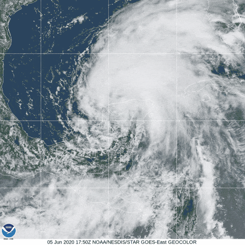
Tropical Storm Cristobal was the 3rd named storm during the 2020 Atlantic Hurricane Season and the first storm of the season to impact the NWS Mobile/Pensacola county warning area in the 2020 season.
Summary of all Local Storm Reports (LSRs) across the area during Tropical Storm Cristobal and LSRs across the region during Cristobal.
Tropical Storm Cristobal made landfall west of our area, but significant impacts were felt across the entire region. The majority of this document will focus on the impacts from coastal flooding and wind across southeast Mississippi, southwest Alabama and northwest Florida. Below are some of the local impacts...
Jump to - Rainfall, Wind, Storm Surge, Tornado, Post-Tropical Cyclone Report, or Additional Information sections.
Interesting Hurricane Cristobal Related Stats
Cristobal is the earliest third named storm on record in the Atlantic Basin.
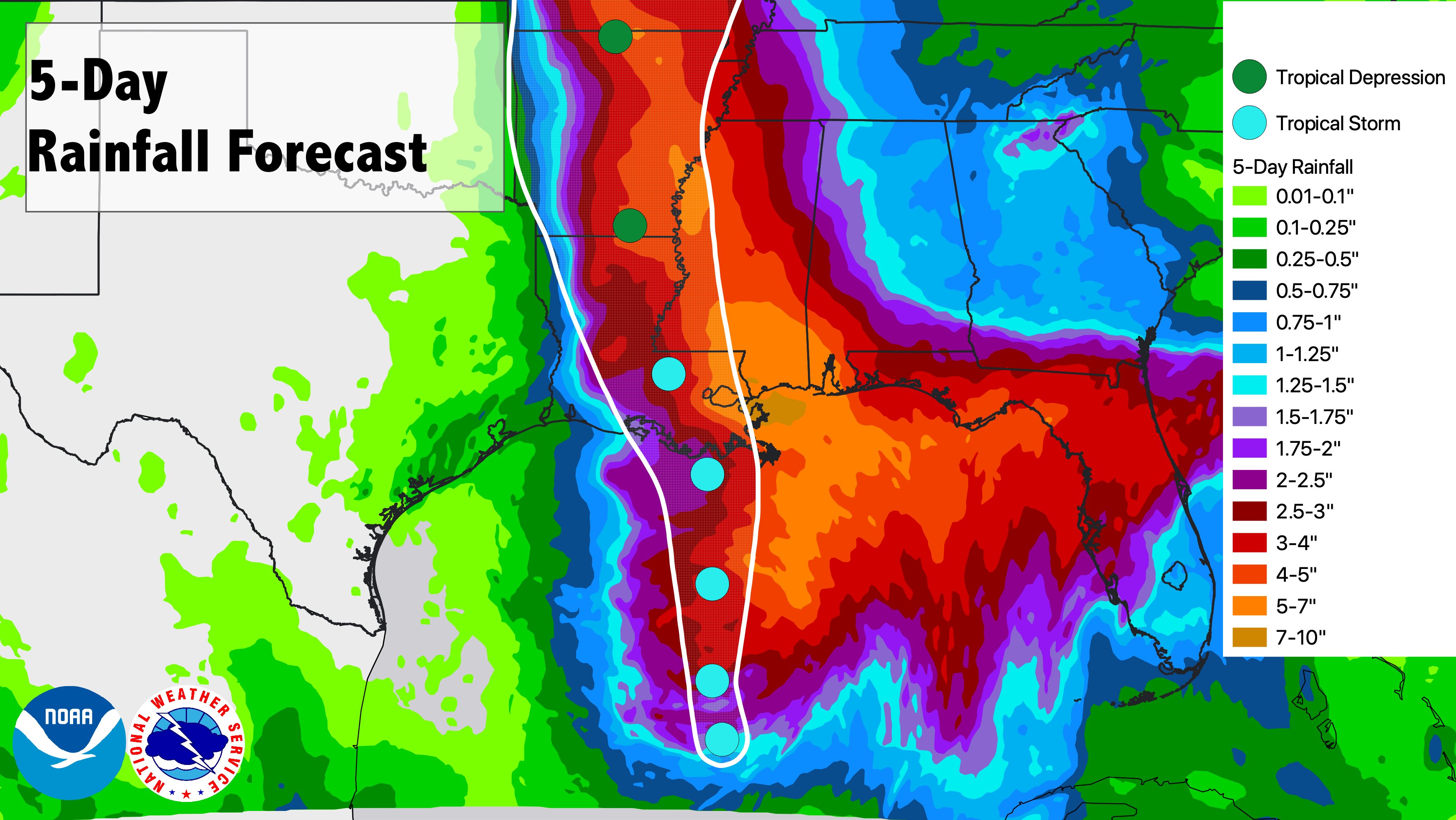
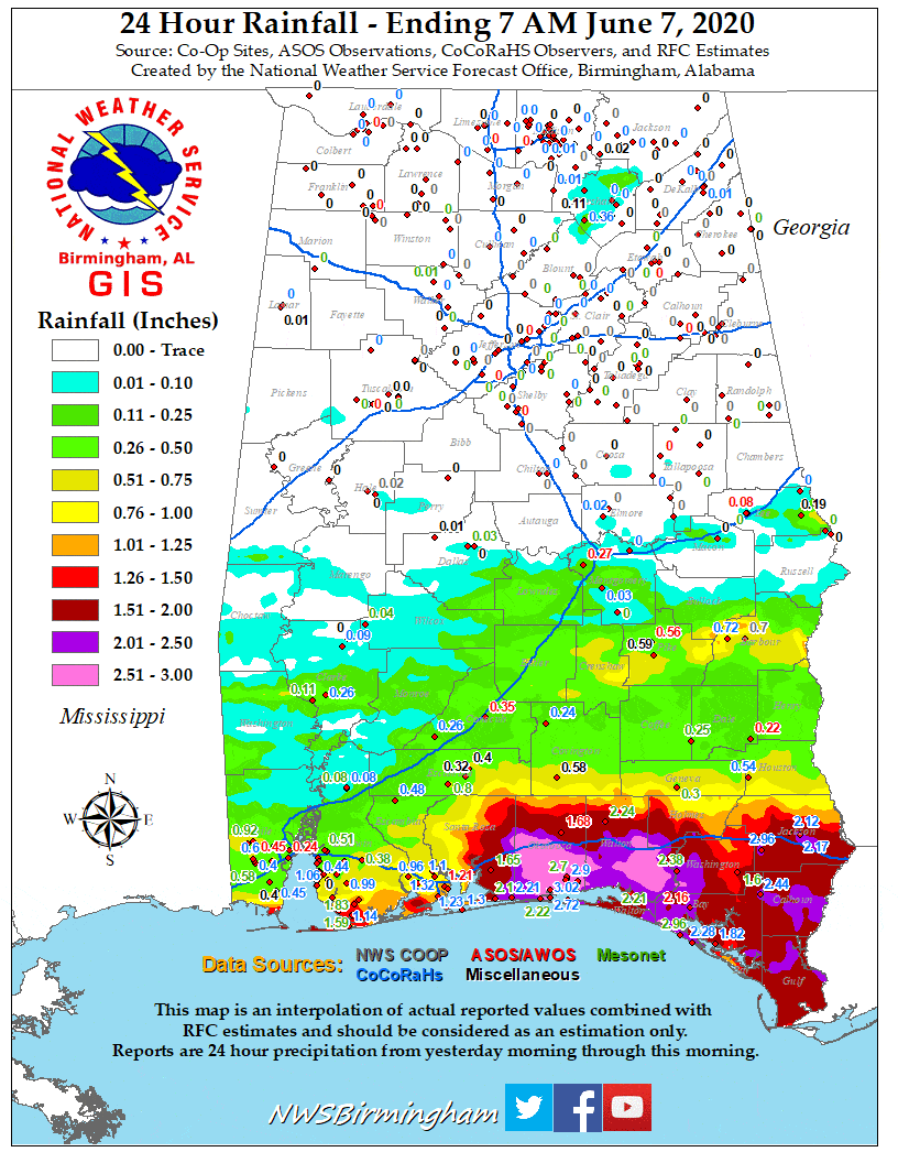 Cristobal's angle of approach to our coastline put much of the area in a favorable location for very heavy rainfall. The highest rainfall amounts generally occurred across the southern and western portions of the area. The image below via the NWS and NWS Weather Prediction Center shows the cone overlaid on top of the predicted rainfall amounts ahead of landfall. Meanwhile, the loop of rainfall imagery to the right shows where the heavy rainfall fell each day, starting in northwest Florida on June 6th and migrating further west each day (note: thanks to NWS Birmingham for the state rainfall imagery).
The highest storm total rain of 10.33" occurred in West Mobile, AL. Widespread rainfall amounts of 7"+ fell across the southern portion of our area. Heavy rain in Mobile County resulted in some flooding across the county. A water rescue was made in Prichard due to a car being stranded in floodwaters. Although widespread flooding was not noted during Cristobal, the excessive rainfall brought a 1-2 category improvement in the drought. Along the local rivers, heavy rainfall led to rapid rises, especially along the flashier rivers. However, there were no major impacts along any rivers during this event.
A list of some of the higher rainfall totals can be found in the Post-Tropical Cyclone Report at the bottom of this webpage. A comprehensive list of rainfall totals across the area can be found on our dedicated rainfall webpage for Cristobal.
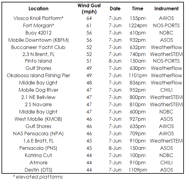
Wind gusts of 50+ mph were observed across much of the coast during Tropical Storm Cristobal with the strongest winds along the immediate coastline of Mobile Bay. The highest land-based wind gusts observed across the region were at Brookley Field in downtown Mobile with gusts to 56 mph late in the evening on June 7th.
Across southwest Alabama, downed trees and power lines led to scattered power outages throughout Mobile and Baldwin Counties during Tropical Storm Cristobal.
A list of the highest wind gusts (44+ mph) can be found in the table below.
The comprehensive list of land and marine wind gusts (converted to mph) can be found at this link.
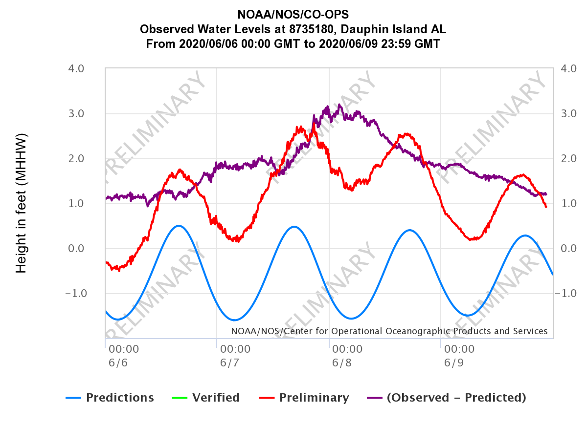
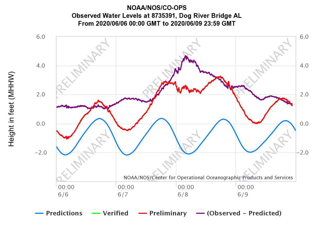
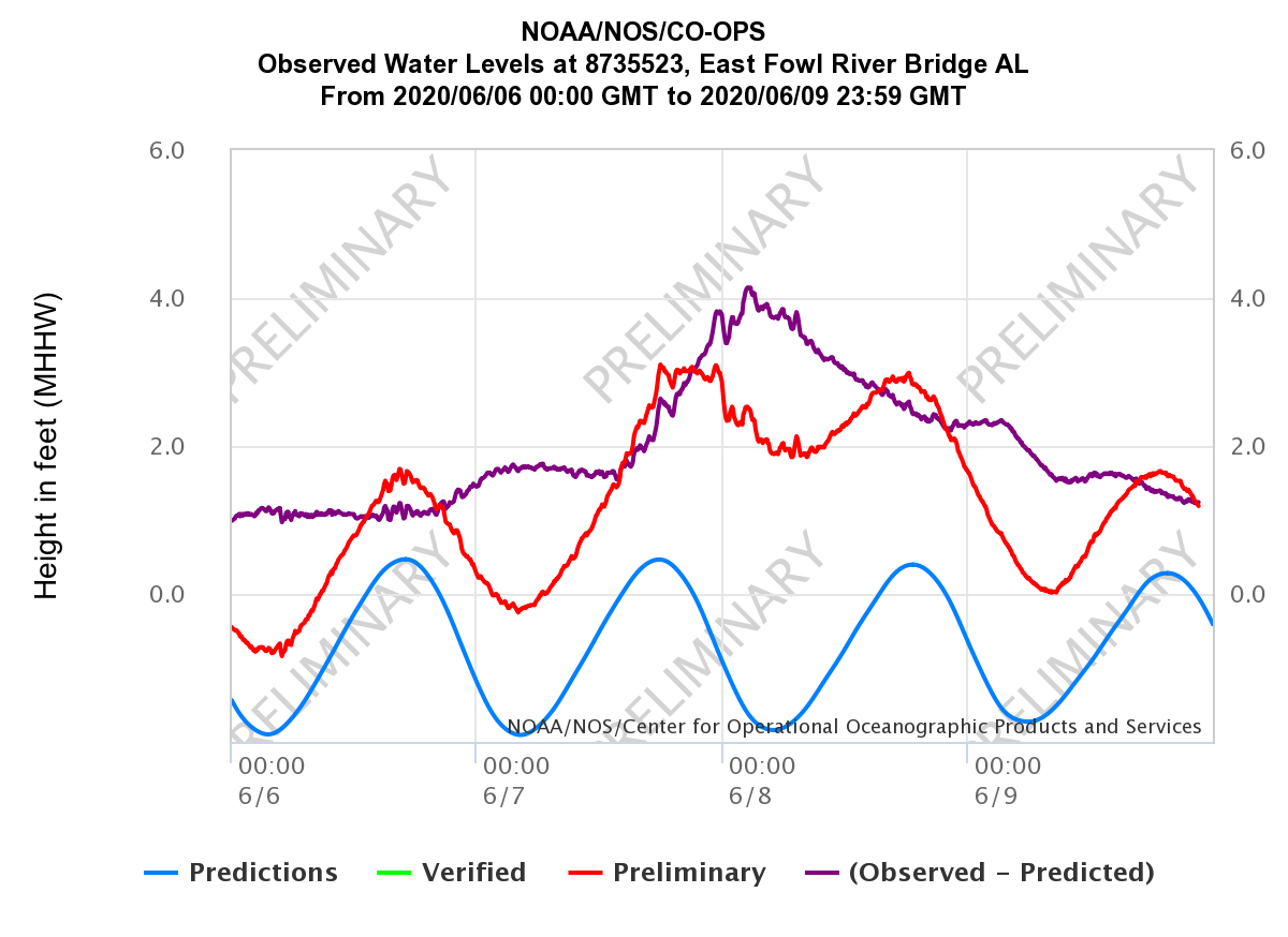
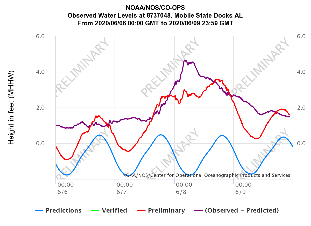
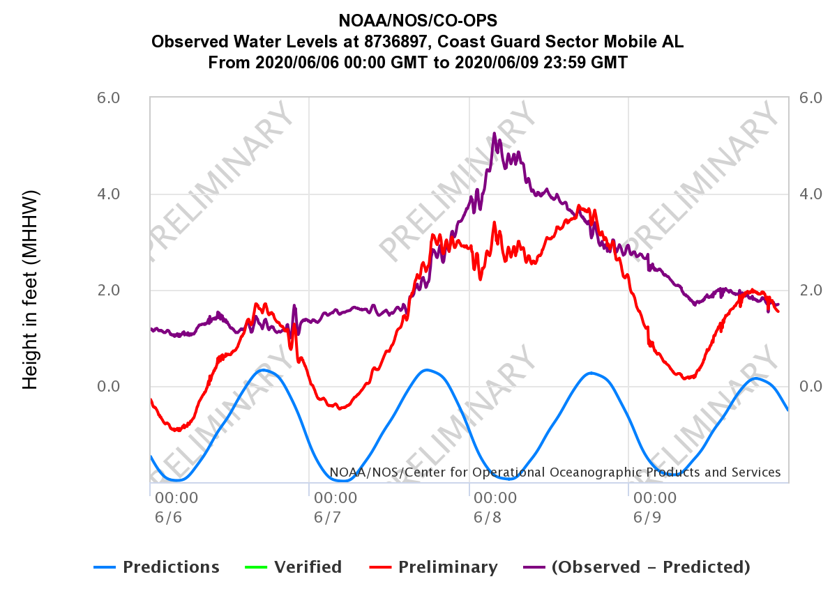
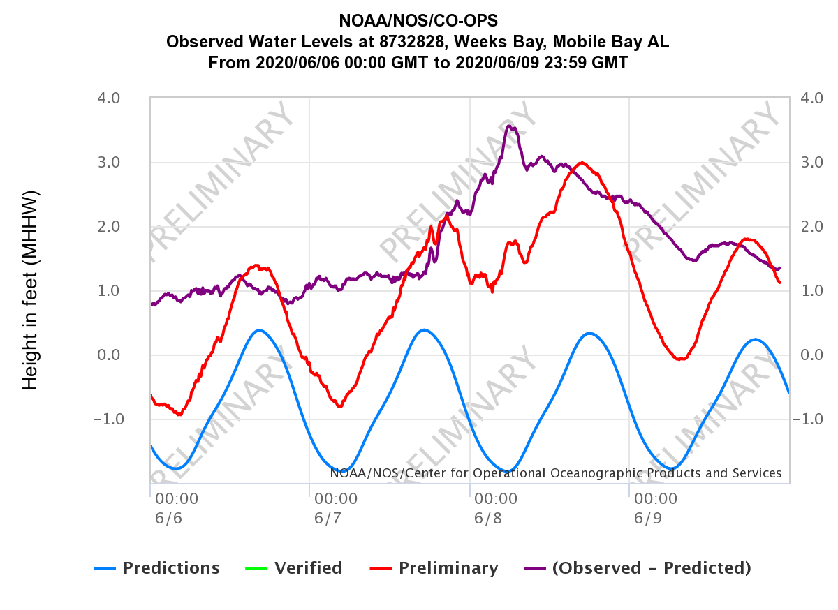
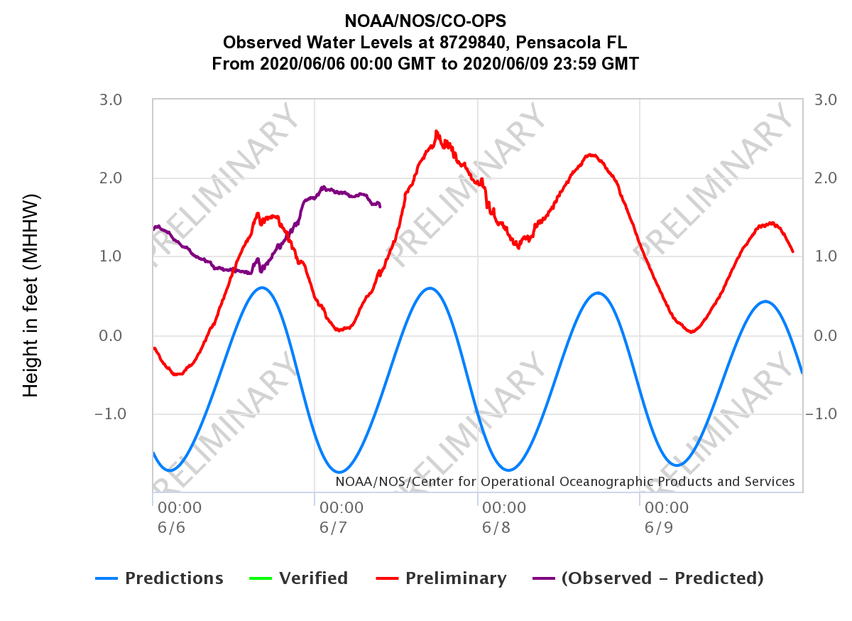
Coastal flooding was greatest on the eastern side of Tropical Storm Cristobal due to its angle of approach to the coast. High tide was completely out of phase with the time of the maximum coastal flooding, thus the majority of our coastline only experienced moderate to minor coastal flooding. If the highest water levels had corresponded with high tide, inundation would have been further amplified, especially across northern Mobile Bay. Below is a list of the peak inundation for all tidal gauges across the area during Cristobal.
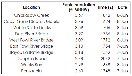
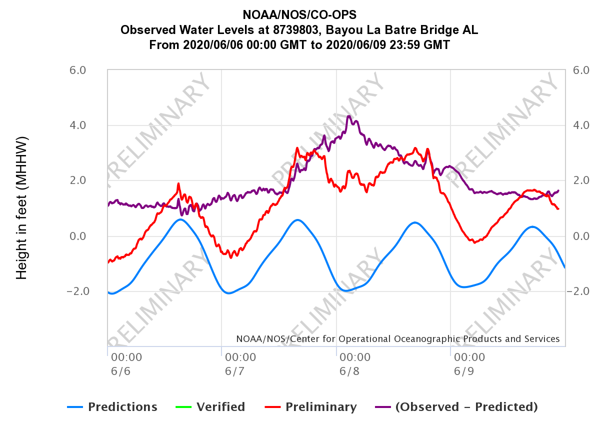
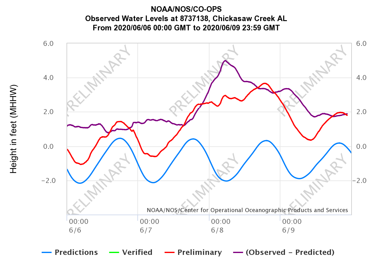
The highest coastal flood levels across our area were observed in the northern portion of Mobile Bay, as seen in the Mobile State Docks and US Coast Guard Sector Mobile graphs at the bottom of this section. The highest inundation occurred after landfall on Monday, June 8th in northern Mobile Bay as the winds turned from easterly to southeasterly, which pushed more water into the northern reaches of the bay. Peak inundation was generally around 3-4 feet (moderate coastal flooding levels) in northern Mobile Bay based on official tide gauges.
Many low-lying coastal roads across the area were impacted from the coastal flooding, including Shell Belt Rd, Coden Belt Rd, Highway 193 Dauphin Island Causeway, north side of the Dog River Bridge on the Dauphin Island Parkway, the east and westbound lanes of the Highway 90 Causeway over Mobile Bay, and parts of the Cochrane Causeway. The image below is a comparison view from the morning and afternoon hours on June 8th from the Causeway over Mobile Bay via the Mobile Traffic social media account (showing the ALGOTraffic website and Alabama Department of Transportation webcam view).

In the southern portion of Mobile County, water encroached into the yards of homes along the Dog River. On the west end of Dauphin Island in southern Mobile County, sand was pushed onto Bienville Blvd with coastal flooding impacting much of the western end of the island. The last 3 miles of Bienville Blvd on the west end of the island was closed due to the flooding with reports of up to 5 feet of sand covering parts of the road. Parts of the Causeway leading to Dauphin Island were closed at times due to coastal flooding during the event.
Further east, more minor coastal flooding was observed along the Baldwin County coastline and across northwest Florida. Minor coastal flooding occurred along portions of Fort Morgan Rd and along the Fish River in Baldwin County. Large breaking waves also resulted in beach erosion along the immediate coast in Baldwin County. Minor coastal flooding was observed along Bayou Texar and Bayou Grande areas in Escambia County FL with a significant amount of water and sand along portions of Highway 399, particularly in the Fort Pickens and Opal Beach areas. In Okaloosa County, the sea wall at Meigs Park in Shalimar was damaged with minor coastal flooding noted in the area.
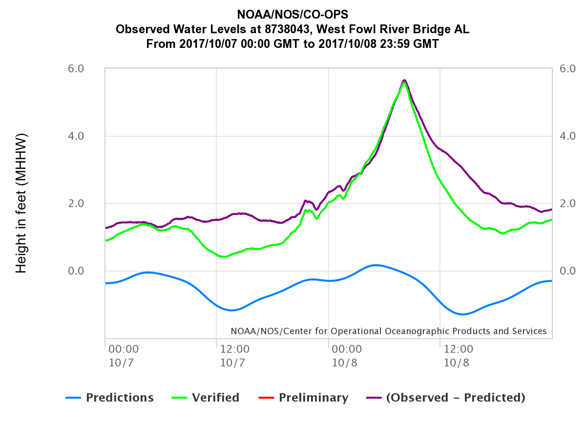
Official NOAA/NOS/CO-OPS tide gauges were used to measure the coastal flooding across the area during Tropical Storm Cristobal. Time series plots from several of these NOAA/NOS/CO-OPS tide gauges across coastal Alabama and northwest Florida can be viewed below. (Note: MHHW datum is used as a proxy for inundation above normally dry ground)
More information soon...
POST TROPICAL CYCLONE REPORT...TROPICAL STORM CRISTOBAL
NATIONAL WEATHER SERVICE MOBILE AL
339 PM CDT SUN JUN 14 2020

NOTE: THE DATA SHOWN HERE ARE PRELIMINARY....AND SUBJECT TO UPDATES
AND CORRECTIONS AS APPROPRIATE.

THIS REPORT INCLUDES EVENTS OCCURRING WHEN WATCHES AND/OR WARNINGS
WERE IN EFFECT...OR WHEN SIGNIFICANT FLOODING ASSOCIATED WITH
CRISTOBAL OR ITS REMNANTS WAS AFFECTING THE AREA.

COUNTIES INCLUDED...BALDWIN...BUTLER...CHOCTAW...CLARKE...CONECUH...
COVINGTON...CRENSHAW...ESCAMBIA AL...ESCAMBIA FL...GEORGE...
GREENE...MOBILE...MONROE...OKALOOSA...PERRY...SANTA ROSA...STONE...
WASHINGTON...WAYNE...WILCOX

JUN 14...UPDATED FOR...ADDITIONAL RAINFALL TOTALS AND COUNTY STORM
IMPACTS


A. LOWEST SEA LEVEL PRESSURE/MAXIMUM SUSTAINED WINDS AND PEAK GUSTS
---------------------------------------------------------------------
METAR OBSERVATIONS...
NOTE: ANEMOMETER HEIGHT IS 10 METERS AND WIND AVERAGING IS 2 MINUTES
---------------------------------------------------------------------
LOCATION  ID    MIN    DATE/     MAX      DATE/     PEAK    DATE/
LAT  LON        PRES   TIME      SUST     TIME      GUST    TIME
DEG DECIMAL     (MB)   (UTC)     (KT)     (UTC)     (KT)    (UTC)
---------------------------------------------------------------------
KMOB-MOBILE/BATES FIELD AL
30.68 -88.25  1000.5  08/0156   120/027  08/0156   130/040 08/0227

KBFM-MOBILE DOWNTOWN AL
30.64 -88.07  1001.1  07/2353   130/033  08/0247   130/049 08/0232

KJKA-JACK EDWARDS AP, GULF SHORES AL
30.29 -87.67  1002.4  08/0055   100/029  07/2315   110/040 07/2335

KPNS-PENSACOLA FL
30.47 -87.20  1004.5  08/0053   130/029  08/0153   160/039 08/0650

KNPA-NAS PENSACOLA, PENSACOLA FL
30.35 -87.32  1003.6  07/2356   130/030  07/1856   110/040 08/0009

KHRT-HURLBURT FIELD FL
30.43 -86.68  1007.2  08/0926   150/022  08/0756   140/037 08/0257

KDTS-DESTIN/FT WALTON BEACH ARPT FL
30.40 -86.47  1007.4  08/0353   140/029  08/0410   140/038 08/0409

KEGI-DUKE FLD/EGLIN AFB FL
30.65 -86.52  1007.0  08/0446   120/021  08/0446   130/034 08/0456

KCEW-CRESTVIEW FL
30.79 -86.52  1007.2  07/2253   190/015  08/1618   120/030 08/0505

KNSE-WHITING FLD-N NAS, MILTON FL
30.72 -87.02  1003.9  08/0056   130/023  08/0142   130/035 08/0142

K79J-ANDALUSIA/OPP AP AL
31.32 -86.41  1009.6  08/1356   170/011  08/1553   160/021 08/1627

KGZH-EVERGREEN AL
31.42 -87.04  1006.2  08/0653   170/021  07/2213   120/028 08/0408


NON-METAR OBSERVATIONS...
NOTE: ANEMOMETER HEIGHT IN METERS AND WIND AVERAGING PERIOD IN
MINUTES INDICATED UNDER MAXIMUM SUSTAINED WIND IF KNOWN
---------------------------------------------------------------------
LOCATION  ID    MIN    DATE/     MAX      DATE/     PEAK    DATE/
LAT  LON        PRES   TIME      SUST     TIME      GUST    TIME
DEG DECIMAL     (MB)   (UTC)     (KT)     (UTC)     (KT)    (UTC)
---------------------------------------------------------------------
XBUC-BUCCANEER YACHT CLUB (WEATHERFLOW) AL
30.58 -88.07                  I 110/035  08/0247   080/045 07/2332
                                  10.4

XGLF-GULF SHORES/FOLEY (WEATHERFLOW) AL
30.36 -87.65                  I 170/023  08/1555   100/043 07/2330
                                  10.4

XGBZ-GULF BREEZE (WEATHERFLOW) FL
30.36 -87.16                  I 120/024  08/0024   130/040 08/0134
                                    15

XCBS-CRYSTAL BEACH (WEATHERFLOW) FL
30.39 -87.41                  I 130/023  08/0421   130/035 08/0421
                                  15.2


B. MARINE OBSERVATIONS...
NOTE: ANEMOMETER HEIGHT IN METERS AND WIND AVERAGING PERIOD IN
MINUTES INDICATED UNDER MAXIMUM SUSTAINED WIND IF KNOWN
---------------------------------------------------------------------
LOCATION  ID    MIN    DATE/     MAX      DATE/     PEAK    DATE/
LAT  LON        PRES   TIME      SUST     TIME      GUST    TIME
DEG DECIMAL     (MB)   (UTC)     (KT)     (UTC)     (KT)    (UTC)
---------------------------------------------------------------------
42012-ORANGE BEACH, AL BUOY
30.07 -87.56  1001.7  07/2250   120/035  07/2310   120/049 07/2310
                                   3.8

DPIA1-DAUPHIN ISLAND, AL/V
30.25 -88.07  999.8   08/0100   110/039  07/2300   120/043 07/2300
                                  13.5

KATA1-KATRINA CUT, AL
30.26 -88.21                  I 120/038  07/1800   130/046 07/2036
                                  15.7

MBLA1-MIDDLE BAY LIGHT, AL
30.44 -88.01                  I 070/041  07/2300   080/045 08/0248
                                  14.2

XFPL-FAIR POINT LIGHT (PENSACOLA BAY)
30.37 -87.21  1003.5  08/0136   140/031  08/0141   140/042 08/0136
                                   4.6

XOFP-OKALOOSA ISLAND FISHING PIER
30.39 -86.59                  I 130/034  08/0206   130/043 08/0131
                                  13.7

XFWB-FT. WALTON BEACH (W CHOCTAWHATCHEE BAY)
30.40 -86.56  1003.2  07/2024   170/029  08/0329   170/037 08/0329
                                   7.3


C. STORM TOTAL RAINFALL FROM 0000 UTC JUN 06 UNTIL 0000 UTC JUN 09
---------------------------------------------------------------------
CITY/TOWN                    COUNTY               ID         RAINFALL
LAT LON                                                       (IN)
DEG DECIMAL
---------------------------------------------------------------------
WEST MOBILE                  MOBILE              KALMOBIL163  10.33
30.64  -88.24

13 SE LUCEDALE               GEORGE              MS-GG-2       9.56
30.79  -88.43

BIG CREEK LAKE               MOBILE              COOP          8.60
30.72  -88.30

10 W MOBILE                  MOBILE              AL-MB-71      8.29
30.67  -88.26

2 NW FAIRHOPE                BALDWIN             AL-BW-1       8.20
30.54  -87.89

3 WNW SUMMERDALE             BALDWIN             AL-BW-85      7.32
30.50  -87.74

MOBILE AIRPORT               MOBILE              KMOB          7.00
30.68  -88.24

0 SSW LOXLEY                 BALDWIN             AL-BW-26      6.85
30.62  -87.76

3 N GULF SHORES              BALDWIN             AL-BW-66      6.68
30.31  -87.71

DAUPHIN ISLAND               MOBILE              KALDAUPH12    6.31
30.24  -88.10

1 NNW SHALIMAR               OKALOOSA            FL-OK-41      6.27
30.46  -86.59

SILAS                        CHOCTAW             PUBLIC        6.27
31.76  -88.33

2 NE PERKINSON               STONE               MS-ST-4       6.08
30.80  -89.11

1 NW DESTIN                  OKALOOSA            FL-OK-33      5.52
30.40  -86.49

11 N BAY MINETTE             BALDWIN             AL-BW-59      5.41
31.04  -87.74

6 WSW CASTLEBERRY            CONECUH             AL-CC-1       4.79
31.27  -87.12

2 NNW NICEVILLE              SANTA ROSA          FL-SR-12      4.63
30.41  -86.90

CRESTVIEW (BOB SIKES AIR     OKALOOSA            KCEW          4.62
30.77  -86.52

6 N TOXEY                    CHOCTAW             AL-CW-1       4.21
32.00  -88.29

6 SW GROVE HILL              CLARKE              AL-CK-3       4.07
31.64  -87.85

PENSACOLA AIRPORT            ESCAMBIA            KPNS          3.35
30.42  -87.19


D. INLAND FLOODING...
---------------------------------------------------------------------
---------------------------------------------------------------------
GREENE...MINOR RIVER FLOODING ALONG THE CHICKASAWHAY RIVER AT
LEAKESVILLE.


E. MAXIMUM OBSERVED WATER LEVEL (WL)...
---------------------------------------------------------------------
ID     CITY/TOWN       COUNTY     STATE  WL  DATUM  DATE/   SOURCE
       OR LOCATION                      (FT)        TIME
---------------------------------------------------------------------
OBLA1  MOBILE STATE DO MOBILE       AL  3.59 MHHW   08/1706 NOS
30.7083  -88.0433

MCGA1  USCG SECTOR MOB MOBILE       AL  3.76 MHHW   08/1624 NOS
30.6483  -88.0583

BYSA1  DOG RIVER BRIDG MOBILE       AL  3.27 MHHW   08/1736 NOS
30.5652  -88.0880

EFRA1  E FOWL RIVER BR MOBILE       AL  3.10 MHHW   07/1754 NOS
30.4437  -88.1139

BLBA1  BAYOU LA BATRE  MOBILE       AL  3.18 MHHW   07/1542 NOS
30.4057  -88.2477

DILA1  DAUPHIN ISLAND  MOBILE       AL  2.78 MHHW   07/2042 NOS
30.2500  -88.0750

WBYA1  WEEKS BAY       BALDWIN      AL  2.99 MHHW   08/1648 NOS
30.4169  -87.8254

CIKA1  CHICKASAW CREEK MOBILE       AL  3.67 MHHW   08/1842 NOS
30.7819  -88.0736

PCLF1  PENSACOLA BAY   ESCAMBIA     FL  2.60 MHHW   07/1748 NOS
30.4044  -87.2112

REMARKS: MODERATE COASTAL FLOODING OCCURRED ACROSS MANY COASTAL
LOCATIONS, PARTICULARLY IN AND AROUND THE MOBILE BAY REGION. SOME
ROADS WERE CLOSED, INCLUDING THE US HWY 90 CAUSEWAY, THE HWY 193
DAUPHIN ISLAND CAUSEWAY, SHELL BELT/CODEN ROAD, THE FOOT OF THE DOG
RIVER BRIDGE ON DAUPHIN ISLAND PARKWAY, AND PART OF THE COCHRANE
CAUSEWAY. MORE MINOR COASTAL FLOODING WAS OBSERVED FURTHER EAST
ACROSS THE WESTERN FLORIDA PANHANDLE. THE MHHW DATUM IS USED AS A
PROXY FOR INUNDATION ABOVE NORMALLY DRY GROUND.


F. TORNADOES...
---------------------------------------------------------------------
(DIST)CITY/TOWN              COUNTY           DATE/         EF SCALE
LAT LON (DEG DECIMAL)                         TIME(UTC)    (IF KNOWN)
DESCRIPTION
---------------------------------------------------------------------


G. STORM IMPACTS BY COUNTY...
---------------------------------------------------------------------
COUNTY            DEATHS           INJURIES             EVACUATIONS
DESCRIPTION
---------------------------------------------------------------------
MOBILE               0                 0                     0

STORM SURGE RESULTED IN THE FLOODING OF LOW LYING COASTAL ROADS
ACROSS THE AREA, INCLUDING SHELL BELT RD, CODEN BELT RD, THE HWY 193
DAUPHIN ISLAND CAUSEWAY, THE NORTH SIDE OF THE DOG RIVER BRIDGE ON
DAUPHIN ISLAND PARKWAY, AND THE EAST AND WEST BOUND LANES OF THE US
HWY 90 MOBILE BAY CAUSEWAY. WATER ENCROACHED INTO THE YARDS OF SOME
HOMES ALONG THE DOG RIVER. THE LAST 3 MILES OF BIENVILLE BLVD ON THE
WEST END OF DAUPHIN ISLAND WERE CLOSED DUE TO FLOODING. THERE WAS UP
TO 5 FEET OF SAND REPORTED ON PARTS OF THE ROAD. HEAVY RAIN RESULTED
IN SOME FLOODING ACROSS THE COUNTY. A WATER RESCUE WAS MADE IN
PRICHARD DUE TO A CAR BEING STRANDED IN THE FLOOD WATERS.

BALDWIN              0                 0                     0

STORM SURGE PRODUCED MINOR FLOODING ALONG PORTIONS OF FORT MORGAN
ROAD AND ALONG THE FISH RIVER. A FEW TREES WERE DOWNED AROUND THE
COUNTY. LARGE BREAKING WAVES RESULTED IN SOME BEACH EROSION ALONG
THE IMMEDIATE COAST.

ESCAMBIA FL          0                 0                     0

STORM SURGE RESULTED IN MINOR FLOODING ALONG BAYOU TEXAR AND BAYOU
GRANDE AREAS. HIGH SURF AND STORM SURGE PRODUCED A SIGNIFICANT
AMOUNT OF WATER AND SAND ALONG PORTIONS OF HIGHWAY 399, PARTICULARLY
IN THE FORT PICKENS AND OPAL BEACH AREAS.

OKALOOSA             0                 0                     0

THE SEA WALL AT MEIGS PARK IN SHALIMAR WAS DAMAGED. OTHERWISE, ONLY
MINOR COASTAL FLOODING WAS NOTED IN THE AREA.

$$

LEGEND:
I-INCOMPLETE DATA
E-ESTIMATED
NHC Advisory Archive
WPC Archive
NHC Tropical Cyclone Report
NOAA Tides & Currents - Highest Storm Water Levels - not available yet
NOAA Tides & Currents - Archived Storm QuickLooks - not available yet
NWS Local Write-Ups and Webpages:
NWS New Orleans
NWS Lake Charles
NWS Milwaukee
NWS Green Bay
Acknowledgements: Page created by Morgan Barry (forecaster), Joe Maniscalco (forecaster), & Don Shepherd (lead forecaster). Updated by Michael Mugrage (Forecaster).
LAST UPDATED: March 2024

