
A heat wave over the Southwest will intensify this week, peaking and expanding into the Intermountain West and northern High Plains this weekend. Critical to extremely critical fire weather conditions are forecast from the Northwest and the northern Great Basin this weekend. Particularly Dangerous Situation Red Flag Warnings have been issued. Read More >
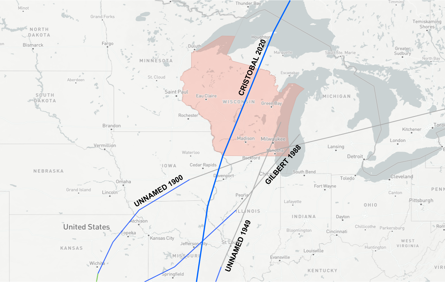
Earlier this week, Wisconsin had an unfamiliar visitor in the form of a tropical system named Cristobal. Cristobal's appearance on Tuesday, June 9, marked the first time a tropical depression had ever crossed into the state. Other tropical systems had clipped the southeast corner of the state before; an unnamed storm in 1900, another one in 1949, and then the remnants of Gilbert in 1988, but these storms weakened to extratropical cyclones (another name for our run of the mill, "Low pressure systems," around here) before doing so. Not only was Cristobal Wisconsin's first tropical depression, but its path was the furthest northwest ever taken by a tropical system since the beginning of records. Below is a quick summary concerning Cristobal.
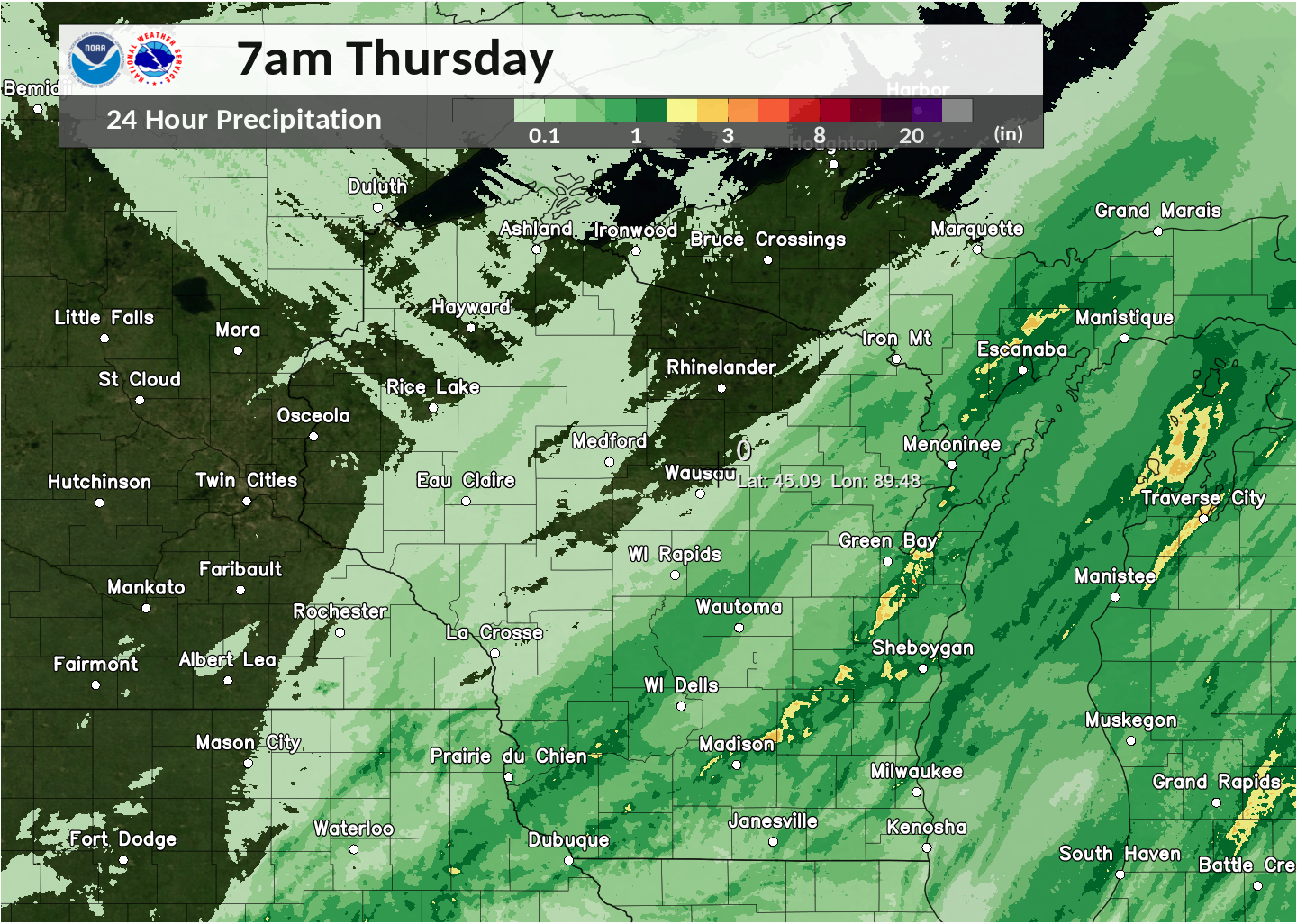
Cristobal began moving into Wisconsin during the afternoon hours on Tuesday, June 9. It was fairly progressive in nature, quickly clearing the state by 6 am on Wednesday, June 10, but in that time it managed to dump a considerable amount of rain over parts of Iowa, Minnesota, and western and north-central Wisconsin. This was owed to Cristobal's surplus of tropical moisture, as precipitable water values were observed to be close to 225% of normal for this time of year in Wisconsin. Cristobal's moisture lingered into the day on Wednesday, when a second low pressure system and frontal boundary gave much of the southern half of the state a second shot of rain. Details on the heavy rain and flooding in western Wisconsin from the NWS La Crosse.
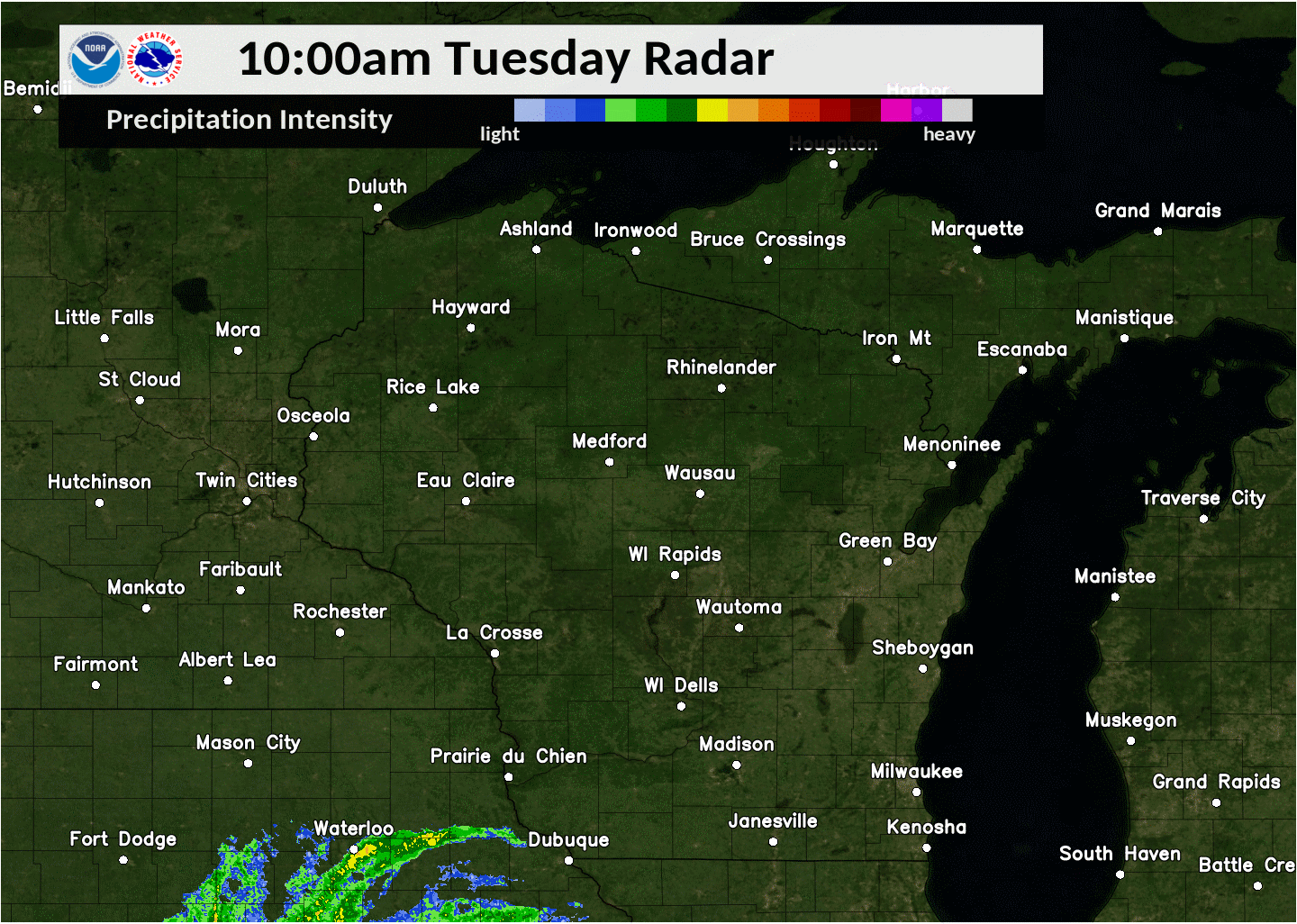
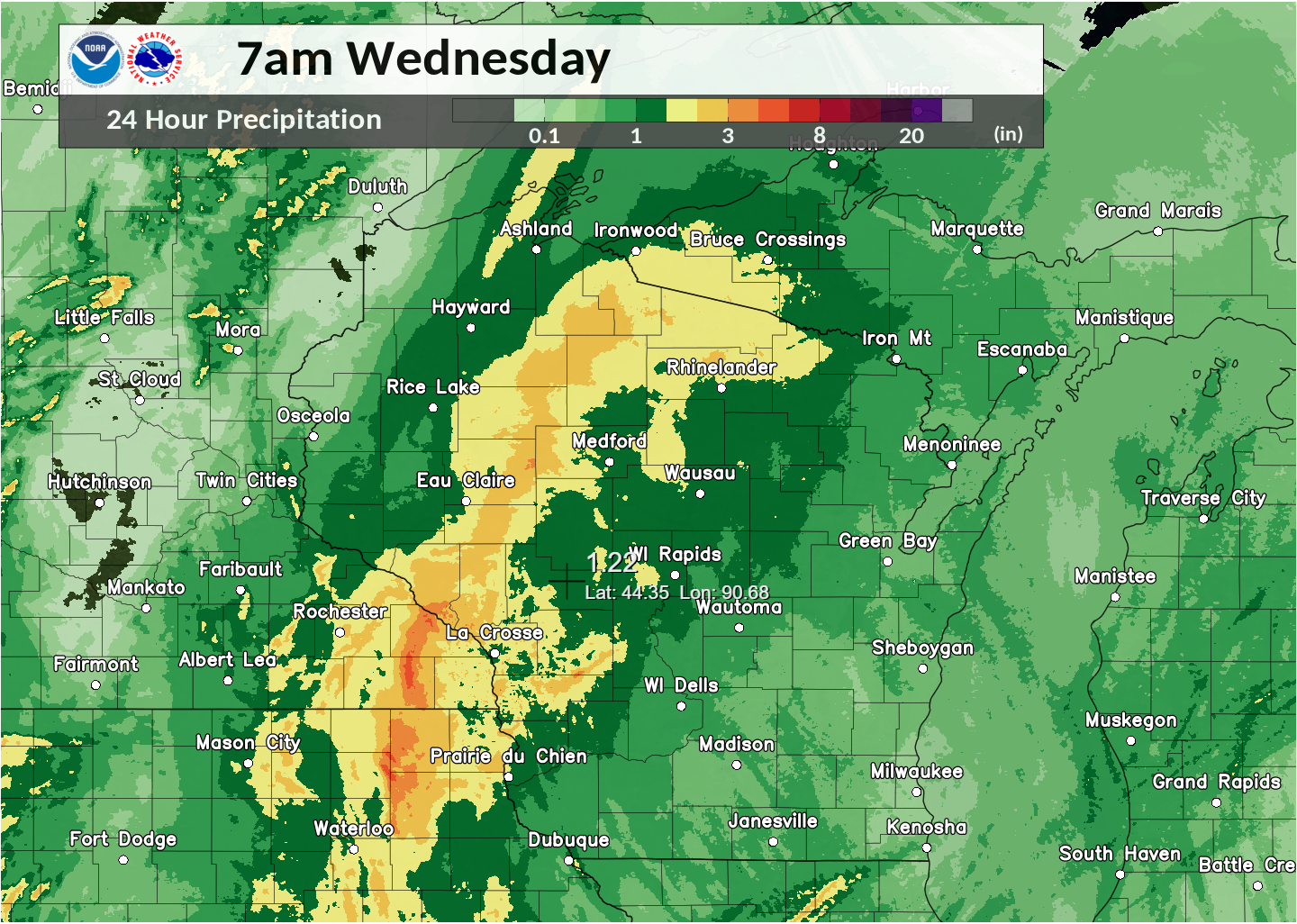
Radar imagery (above, top image) showing Cristobal move across the state Tuesday into Tuesday night and then a second round of rain during the day on Wednesday. 24 Hr rainfall in inches (above, bottom image) ending at 7am on Wednesday, June 10 showing rainfall totals from Cristobal.
South-central and southeast Wisconsin missed out on most of the heavy rain from Cristobal, but its low pressure broke June records and brought gusty winds to the area. Of note, The Fond du Lac airport managed to record a 51 mph wind gust as the system passed by on Tuesday. Additionally, Madison recorded a low pressure of 988.0 mb (29.2 in) which broke the previous record lowest June pressure of 990.2 mb (29.24in).

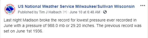
Peak wind gusts in mph (above image) recorded during the day on Tuesday and overnight into early Wednesday morning. On the right is a brief social media post announcing the broken low pressure record in Madison.
As mentioned earlier, even though Cristobal had moved off to the north during the early hours of Wednesday, a good amount of tropical moisture remained in its wake. A second low pressure system and attendant frontal boundary approached from the west on the heels of Cristobal and brought a secondary swath of rain during the daytime hours on Wednesday. Interestingly enough, parts of south-central and southeast Wisconsin saw more rain out of this secondary round than what fell in association with the passing of Cristobal.
A lot of the heavy rain that fell during the day on Wednesday fell during a period of an hour to and hour and a half. This caused localized flooding, including the partial closure of Interstate 41 on the south side of Fond du Lac. A few embedded cells also became strong enough to produce up to 1 inch hail. Below is a summary of storm reports that occurred during the day on Wednesday.
..TIME... ...EVENT... ...CITY LOCATION... ...LAT.LON...
..DATE... ....MAG.... ..COUNTY LOCATION..ST.. ...SOURCE....
..REMARKS..
0616 PM Heavy Rain 3 E Lomira 43.59N 88.38W
06/10/2020 M2.09 inch Fond du Lac WI Mesonet
Mesonet station CW6301 Campbellsport.
0616 PM Heavy Rain 2 SSE FOND DU LAC 43.76N 88.43W
06/10/2020 M2.70 inch Fond du Lac WI Broadcast Media
REPORTED FROM WFRV.
0616 PM Heavy Rain 3 E LOMIRA 43.59N 88.38W
06/10/2020 M2.09 inch Fond du Lac WI Mesonet
MESONET STATION CW6301 CAMPBELLSPORT.
0615 PM Heavy Rain Howards Grove 43.83N 87.83W
06/10/2020 M2.14 inch Sheboygan WI Mesonet
Mesonet station FW1977 Howards Grove.
0615 PM Heavy Rain 2 NW MIDDLETON 43.12N 89.53W
06/10/2020 M1.84 inch Dane WI AWOS
AWOS STATION KC29 MIDDLETON.
0615 PM Heavy Rain HOWARDS GROVE 43.83N 87.83W
06/10/2020 M2.14 inch Sheboygan WI Mesonet
MESONET STATION FW1977 HOWARDS GROVE.
0605 PM Heavy Rain 2 SW FOND DU LAC 43.77N 88.48W
06/10/2020 M2.77 inch Fond du Lac WI ASOS
ASOS STATION KFLD FOND DU LAC AIRPORT.
0602 PM Heavy Rain 3 NNE Riley 43.06N 89.60W
06/10/2020 M1.87 inch Dane WI Mesonet
Mesonet station AS276 4 SE Cross Plains.
0602 PM Heavy Rain 3 NNE RILEY 43.06N 89.60W
06/10/2020 M1.87 inch Dane WI Mesonet
MESONET STATION AS276 4 SE CROSS PLAINS.
0546 PM Flash Flood 2 SSW Fond Du Lac 43.75N 88.46W
06/10/2020 Fond du Lac WI Public
I-41 in Fond Du Lac County closed (both
lanes) from Military Rd to US 151 due to
water over roadway.
0530 PM Heavy Rain Beaver Dam 43.46N 88.84W
06/10/2020 E3.00 inch Dodge WI Public
Estimated 3.0 inches of rain in about an
hour.
0406 PM Heavy Rain 2 WSW Windsor 43.21N 89.38W
06/10/2020 M2.00 inch Dane WI Mesonet
Mesonet station CW2086 Waunakee.
0406 PM Heavy Rain 3 E Lomira 43.59N 88.38W
06/10/2020 M1.87 inch Fond du Lac WI Mesonet
Mesonet station CW6301 Campbellsport.
0402 PM Heavy Rain 3 NNE Riley 43.06N 89.60W
06/10/2020 M2.19 inch Dane WI Mesonet
Mesonet station AS276 4 SE Cross Plains.
0355 PM Heavy Rain 2 NW Middleton 43.12N 89.53W
06/10/2020 M2.03 inch Dane WI AWOS
AWOS station KC29 Middleton.
0145 PM Hail 2 SSW Oconomowoc Lake 43.08N 88.47W
06/10/2020 M1.00 inch Waukesha WI Public
Time estimated from Radar.
0140 PM Hail 1 S Oconomowoc 43.09N 88.50W
06/10/2020 M0.75 inch Waukesha WI Public
0124 PM Hail 1 NE Merton 43.15N 88.30W
06/10/2020 E1.00 inch Waukesha WI NWS Employee
0121 PM Tstm Wnd Dmg Merton 43.14N 88.31W
06/10/2020 Waukesha WI Public
Large Trees snapped.
0116 PM Hail 1 N Hartland 43.11N 88.35W
06/10/2020 M0.70 inch Waukesha WI Broadcast Media

