National Weather Service United States Department of Commerce

Above Normal Temperatures, Strong Thunderstorms, Tropical Development Being Monitored

Well above normal temperatures are forecast to shift from the northern Plains through the Northeast U.S. over the long holiday weekend. A few strong to severe thunderstorm will be possible as well along with a potential for excessive rainfall. A tropical or subtropical depression could form off the Southeast U.S. coast over the weekend while drifting northward to northeastward. Read More >

Click a location below for detailed forecast.

Last Map Update: Fri, Jul 4, 2025 at 3:58:42 pm EDT


Sunny skies and very warm weather for the Fourth of July Weekend. Isolated to scattered mountain storms possible Sunday afternoon and evening.
Warmer than normal temperatures are expected through the weekend. Dry conditions are expected as well, even though a few isolated showers or thunderstorms could develop over the higher elevations today through the weekend. Better rain chances come into play next week.
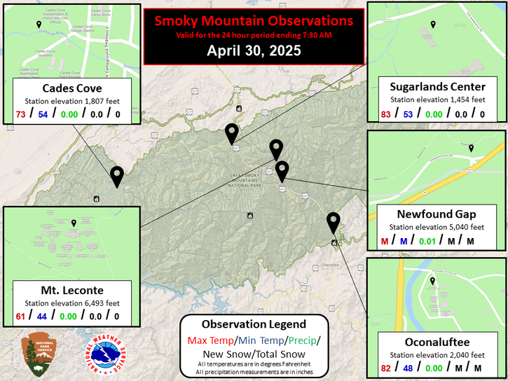
Each observation point is apart of our COOP program (Cooperative Observer Program). Each site has a 24 hour observation period that ends and begins at 8 am local time. Each site records temperature, precipitation, and snowfall data. More information about the COOP program can be found here www.nws.noaa.gov/om/coop/ Data began being collected at: Cades Cover on 01/01/1999 || Mount LeConte on 07/01/1987 || Newfound Gap on 01/01/1991 || Sugarlands Visitor Center on 12/01/1921

 Current Weather Observations...
Location Time
(EDT)
Weather Vsby.
(SM)
Temp.
(ºF)
Dewpt.
(ºF)
Hum.
(%)
Wind
(mph)
Wind Chill / Heat Index
(ºF)
Pres.
(in)
Abingdon VA15:35Mostly Cloudy10825945NNE 7-30.19
Andrews-Murphy NC15:26Partly Cloudy10886649WSW 6-30.13
Chattanooga TN14:53Lightning Observed10926744VRB 595 [HI]30.07
Crossville TN14:53Clear10866448CALM-30.16
Dalton GA15:35Rain \ Mist \ Thunder In The Vicinity2 1/2767290NNW 13-30.08
Knoxville TN (McGhee-Tyson)14:53Cumulonimbus Clouds Observed10906340NW 791 [HI]30.09
Middlesboro KY15:35Clear10886139CALM-30.14
Monroe Cnty TN15:15Clear10896952CALM94 [HI]30.09
Morristown TN10:30VRB 5-30.10
Oak Ridge TN14:53Mostly Clear10926034CALM92 [HI]30.11
Tazewell Cnty VA15:35Partly Cloudy10825438SE 3-30.23
Tri-Cities TN14:53Partly Cloudy10886242VRB 3-30.15
Wise VA15:35Partly Cloudy10825945SE 5-30.24
Greeneville, TN15:15Partly Cloudy10846451CALM-30.14


Local Weather History For July 4th...
Storms hit the area in 2006. $372,000 in wind damage. Flooding was reported in Rogersville.


Briefing Hydrology Past Weather Events Graphical Hazardous Weather Outlook for East Tennessee East Tennessee Observations
Decision Support Hydrology Past Weather Events GHWO Observations Gridded Forecast
Daily Climate for Middle Tennessee Local East Tennessee Climate Tornado Database Tropical Weather Information NOAA Weather Radio
IDSS Point Forecasts Daily Climate Local Climate Tornado Database Tropical Weather Radio
Daily Climate for Middle Tennessee Probabilistic Data for East Tennessee Virtual Tour of the NWS Morristown Office Skywarn Spotter Training for East Tennessee  
Being Prepared Estar Perparado Probabilistic Virtual Tour Spotter Training