National Weather Service United States Department of Commerce
Click a location below for detailed forecast.

Last Map Update: Fri, May 30, 2025 at 7:52:42 pm EDT


A cold front will move across the area this afternoon with clearing conditions overnight. Isolated showers and thunderstorms are possible on Saturday afternoon and Sunday afternoon as northwest flow aloft brings brief disturbances to the area. Drier weather and warming conditions are expected early next week as ridging builds into the area.
Each observation point is apart of our COOP program (Cooperative Observer Program). Each site has a 24 hour observation period that ends and begins at 8 am local time. Each site records temperature, precipitation, and snowfall data. More information about the COOP program can be found here www.nws.noaa.gov/om/coop/ Data began being collected at: Cades Cover on 01/01/1999 || Mount LeConte on 07/01/1987 || Newfound Gap on 01/01/1991 || Sugarlands Visitor Center on 12/01/1921
Daily climate data (normals and records) for today for the sites plotted. The current normals period is 1991-2020.
NOAA 2025 Hurricane Season Outlook. There's a 60% chance of an above normal season, a 30% of near normal, and a 10% of a below normal season. The predictions for storms are as follow: 13 to 19 named storms, of which 6 to 10 will be hurricanes, and 3 to 5 hurricanes will reach major (Category 3 and stronger) strength. Hurricane season starts June 1! Visit hurricanes.gov for the latest on the hurricane season.

 Current Weather Observations...
Location Time
(EDT)
Weather Vsby.
(SM)
Temp.
(ºF)
Dewpt.
(ºF)
Hum.
(%)
Wind
(mph)
Wind Chill / Heat Index
(ºF)
Pres.
(in)
Abingdon VA19:35Light Drizzle9575182NNW 14G21-29.81
Andrews-Murphy NC19:28Mostly Cloudy10644854NNE 8G20-29.88
Chattanooga TN18:53Light Rain10715556N 20G28-29.87
Crossville TN18:53Clear10615272WNW 8-29.90
Dalton GA19:35Overcast9705661NNW 18G26-29.86
Knoxville TN (McGhee-Tyson)18:53Cumulonimbus Clouds Observed10635165WNW 9-29.85
Middlesboro KY19:35Partly Cloudy10645367CALM-29.85
Monroe Cnty TN19:15Mostly Clear10625577NW 5-29.87
Morristown TN11:4510696894NNE 6-30.19
Oak Ridge TN18:53Clear10665158VRB 6-29.86
Tazewell Cnty VA19:35Overcast10504996WNW 8-29.83
Tri-Cities TN18:53Light Rain10625474W 10-29.80
Wise VA19:35Mostly Cloudy10535193NW 5-29.85
Greeneville, TN19:15Mostly Cloudy10595587WSW 7G14-29.83


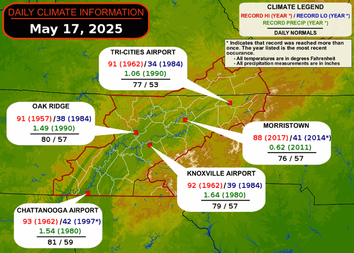
Local Weather History For May 30th...
Storms hit the area in 1974. Wind damaged 14 boats in Blount County. 8" of rain fell in
Maryville.


Briefing Hydrology Past Weather Events Graphical Hazardous Weather Outlook for East Tennessee East Tennessee Observations
Decision Support Hydrology Past Weather Events GHWO Observations Gridded Forecast
Daily Climate for Middle Tennessee Local East Tennessee Climate Tornado Database Tropical Weather Information NOAA Weather Radio
IDSS Point Forecasts Daily Climate Local Climate Tornado Database Tropical Weather Radio
Daily Climate for Middle Tennessee Probabilistic Data for East Tennessee Virtual Tour of the NWS Morristown Office Skywarn Spotter Training for East Tennessee  
Being Prepared Estar Perparado Probabilistic Virtual Tour Spotter Training