National Weather Service United States Department of Commerce

Areas of Extreme Heat and Fire Weather in the Northwest U.S.; Heavy Rain in the West and South-central U.S.

Extreme heat will continue in the interior Northwest into midweek before finally waning. Hot temperatures, dry, gusty winds, and isolated dry thunderstorms will bring critical fire weather. Heavy rain and thunderstorms are expected across portions of the Great Basin, Rockies, and central/southern Plains. An atmospheric river will bring heavy rain and strong winds to southwest Alaska. Read More >

Click a location below for detailed forecast.

Last Map Update: Tue, Aug 26, 2025 at 4:24:27 pm EDT
There are no watches, warnings, or advisories at this time.


The Bristol NOAA Weather Radio will be offline this Tuesday and Wednesday to replace the Antenna and Cabling at the site.
Unseasonably cool and mostly dry conditions through much of the week. Temperatures will be 10 to 15 degrees below normal through Wednesday. Some moderation is expected towards the weekend, but still below normal.
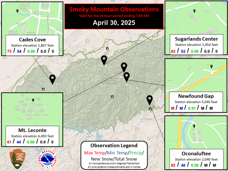
Each observation point is apart of our COOP program (Cooperative Observer Program). Each site has a 24 hour observation period that ends and begins at 8 am local time. Each site records temperature, precipitation, and snowfall data. More information about the COOP program can be found here www.nws.noaa.gov/om/coop/ Data began being collected at: Cades Cover on 01/01/1999 || Mount LeConte on 07/01/1987 || Newfound Gap on 01/01/1991 || Sugarlands Visitor Center on 12/01/1921

 Current Weather Observations...
Location Time
(EDT)
Weather Vsby.
(SM)
Temp.
(ºF)
Dewpt.
(ºF)
Hum.
(%)
Wind
(mph)
Wind Chill / Heat Index
(ºF)
Pres.
(in)
Abingdon VA16:15Mostly Cloudy10684645NNW 8G16-30.18
Andrews-Murphy NC16:02Mostly Cloudy10775343SW 8-30.15
Chattanooga TN15:53Partly Cloudy10795036N 6-30.16
Crossville TN06:53Clear10545086NNW 3-30.19
Dalton GA16:15Partly Cloudy10795544VRB 7-30.13
Knoxville TN (McGhee-Tyson)15:53Mostly Cloudy10754736VRB 3-30.15
Middlesboro KY16:15Mostly Cloudy10754838NW 8-30.19
Monroe Cnty TN15:55Partly Cloudy10755143NNW 7-30.16
Morristown TN10:30VRB 5-30.10
Oak Ridge TN15:53Mostly Cloudy10755041CALM-30.17
Tazewell Cnty VA16:15Overcast10654955NNW 6-30.21
Tri-Cities TN15:53Mostly Cloudy10724944NNW 7-30.16
Wise VA16:15Overcast10625063NW 6-30.23
Greeneville, TN15:50Partly Cloudy10714640N 6-30.16


Local Weather History For August 26th...
Storms hit on 3 straight days in 2002. $133,000 damage. Tree fell on a Johnson City police car.


Briefing Hydrology Past Weather Events Graphical Hazardous Weather Outlook for East Tennessee East Tennessee Observations
Decision Support Hydrology Past Weather Events GHWO Observations Gridded Forecast
Daily Climate for Middle Tennessee Local East Tennessee Climate Tornado Database Tropical Weather Information NOAA Weather Radio
IDSS Point Forecasts Daily Climate Local Climate Tornado Database Tropical Weather Radio
Daily Climate for Middle Tennessee Probabilistic Data for East Tennessee Virtual Tour of the NWS Morristown Office Skywarn Spotter Training for East Tennessee  
Being Prepared Estar Perparado Probabilistic Virtual Tour Spotter Training