Foehn Winds that produced Large Temperature Differences near the Southern Appalachian Mountains
by
David M. Gaffin
ABSTRACT
- A 30-yr (1971-2000) study was conducted to 1) determine the typical characteristics and synoptic conditions of foehn wind events that produced large temperature differences near the southern Appalachian Mountains and 2) further examine those events that produced dewpoint rises. Foehn wind events were identified on both the western and eastern sides of the southern Appalachians by comparing temperatures between a station immediately adjacent to the southern Appalachians (foehn station) and two nearby stations located farther from the mountains (nonfoehn station). A foehn wind event occurred when the following criteria were met: the daily maximum or minimum temperature at the foehn station was at least 3 0C (~5 0F) higher than the nonfoehn station, winds of at least 2.5 m s-1 (~5 kt) at the foehn station must have been from a downslope direction, and warming of at least 3 0C (~5 0F) must have occurred during the period of downslope winds.
- Foehn wind events on the western side typically occurred as southeasterly winds developed ahead of a low pressure system over the mid-Mississippi River valley, while foehn wind events on the eastern side were typically the result of northwesterly winds behind the passage of a shallow cold front. The relatively warm 850-hPa air mass, which was only a couple of degrees cooler than the surface temperatures, was likely the source region of the foehn winds on both sides, although additional flow through gaps likely contributed to the less than theoretically possible warming observed at the foehn stations. Composite soundings of the foehn wind events revealed a vertical temperature and wind profile that was conducive to large-amplitude mountain wave formation, especially on the western side of the southern Appalachians. An interesting (and possibly unique) finding observed with these southern Appalachian foehn wind events (compared with other documented foehn wind events) was the rise in surface dewpoints at the foehn stations during nearly three-fourths of the events on the western side and around one-third of the events on the eastern side. A comparison of the dewpoint-rise composites to the composites from all foehn wind events near the southern Appalachians revealed that the rise in surface dewpoints was mainly the result of a drier initial surface air mass (compared with the 850-hPa air mass) and not necessarily a more moist 850-hPa air mass.
1. Introduction
- Foehn winds are commonly observed in the lee of large mountain ranges and are typically associated with large temperature increases and relative humidity decreases due to adiabatic compression of the descending wind. Near the mountains of the western United States, foehn winds have been frequently documented, including the chinook winds near the Rocky Mountains (Oard 1993; Nkemdirim 1986), the Santa Ana winds near the mountains of southern California (Raphael 2003; Burroughs 1987), and the sundowner winds near the Santa Ynez Mountains (Blier 1998; Ryan and Burch 1992). Foehn winds near the Appalachian Mountains of the eastern United States remain largely undocumented, most likely because they are usually less dramatic and rarer than those observed across the western United States. In general, the Appalachians have less relief and more gentle slopes than the Rockies and most major mountain ranges, and, thus, a smaller potential for adiabatic warming.
- The southern Appalachian Mountains contain the highest mountain peaks with the largest relief in the Appalachian range, with the Smoky Mountains rising to nearly 1500 m (5000 ft) above the Great Tennessee Valley (Fig. 1). Significant mesoscale temperature rises of up to 10 0C (18 0F) as a result of foehn winds have been documented in the lee of the Smoky Mountains (Gaffin 2002). The foehn winds in this particular case study were unusual compared with other documented foehn winds in that the surface dewpoints rose along with the temperature resulting in little change of the relative humidity. The source of this dewpoint rise was found to be a warm and nearly saturated 850-hPa layer (found near the Smoky Mountain ridges around 5000 ft MSL) that had advected north over the mountains. Whether these dewpoint rises are common to foehn wind events near the southern Appalachians remains unknown. Also, the typical characteristics of southern Appalachian foehn winds and the synoptic conditions that produce them remain unknown.
- In the past, constructing a complete climatology of foehn wind events has been a difficult process that often yields inconclusive or unsatisfactory results because of the difficulties in defining the main characteristics of a foehn wind. Although a foehn has been the generic term for a warm, dry wind descending in the lee of a mountain range, these winds have been difficult to define. This difficulty arises because temperature and humidity are not absolute criteria because they depend on conditions before and after the wind (Brinkmann 1971). Temperature differences with foehn winds also vary according to many factors including the airmass characteristics, height of the mountain, occurrence or absence of clouds, and soil conditions. In some cases, the maxima in the nonfoehn air could still exceed the temperature of the descending foehn air if the upstream air mass was cold and the downstream conditions were nearly cloud free with a large sensible heat flux from the ground (Vergeiner et al. 2002). Thus, while foehns are primarily regarded as a downslope wind, the resulting temperature differences between foehn and nonfoehn wind areas are of more interest to the operational forecaster and the general public. With this in mind, a different approach to determining foehn wind events was developed in order to find those days when foehn winds created large differences in the daily high and low temperatures at a foehn station compared with two other nearby nonfoehn stations (which would normally have temperatures similar to those at the foehn station in the absence of a foehn wind). The purpose of this study is to 1) determine the typical characteristics and synoptic conditions of foehn wind events that produced large temperature differences near the southern Appalachian Mountains and 2) further examine those events that produced dewpoint rises.
2. Methodology
- In the southern Appalachian region, a temperature difference of 3 0C (~5 0F) at one station compared with two other stations [which normally have similar temperatures within 20C (~3 0F)] was considered a large temperature discrepancy when comparing daily high and low temperatures. Thus, determining those days when the daily high or low temperature at a foehn station was at least 3 0C warmer than two nearby nonfoehn stations was the first step in determining a foehn wind event. Daily high and low temperatures between 1971 and 2000 were extracted from the Cooperative Summary of the Day CD-ROM (TD3200) produced by the National Climatic Data Center (NCDC). The Knoxville, Tennessee [elevation 293 m (962 ft) MSL] and Greenville-Spartanburg, South Carolina [elevation 287 m (943 ft) MSL] airports (Fig. 1) were chosen as the foehn stations for the western and eastern sides of the southern Appalachians, respectively. These stations are located in the foothills of the highest mountains with the greatest relief in the southern Appalachians and are roughly the same elevation for comparison purposes (they should have roughly the same potential for adiabatic warming due to downslope winds). Although the Asheville, North Carolina airport was closer to the mountains on the eastern side than the Greenville-Spartanburg airport, it was not chosen as a foehn station because its higher elevation [652 m (2140 ft) MSL] would create comparison problems to Knoxville on the western side.
- In determining which two nonfoehn stations should be used for each side of the mountains, a nonfoehn station needed to be close to the foehn station (have similar temperatures climatologically in the absence of a foehn wind) but located away from the adiabatic warming influences of a foehn wind. Also, one of the nonfoehn stations needed to be at a more southern latitude than the foehn station in order to eliminate the possibility that a warm front instead of a foehn wind caused the warming at the foehn station. In the case of a warm front, the southerly nonfoehn station would normally have experienced a high or low temperature greater than, or similar to, the foehn station. Also, this more southerly station would normally report slightly warmer daily highs or lows than the foehn station, which would make any observed warmer temperature of at least 3 0C at the foehn station (compared with the southerly station) that much more significant. The Chattanooga [elevation 205 m (671 ft) MSL] and Crossville [elevation 569 m (1867 ft) MSL], Tennessee, airports were chosen as the two nearby nonfoehn stations on the western side. Although the Crossville airport was located only approximately 100 km (~60 miles) from the Knoxville airport, its location on the Cumberland Plateau [at nearly 300 m (~1000 ft) higher elevation than Knoxville] separated it from any adiabatic warming due to foehn winds in the central Great Tennessee Valley. The plateau would likely either dam the adiabatic warming against the edge of the plateau or offset it with adiabatic cooling as southeast winds ascended up the plateau. The TriCities Regional Airport [elevation 457 m (1500 ft) MSL], in Blountville, Tennessee, was not chosen as a nonfoehn station on the western side because its location near the mountains would likely cause it to experience adiabatic warming on the same days as Knoxville, resulting in similar high or low temperatures. On the eastern side of the southern Appalachians, the Atlanta, Georgia [elevation 308 m (1010 ft) MSL], and Greensboro, North Carolina [elevation 273 m (897 ft) MSL], airports were chosen as the two nearby nonfoehn stations to compare with Greenville-Spartanburg. The Columbia, South Carolina [elevation 65 m (213 ft) MSL], airport was not chosen as a nonfoehn station because its downwind location from the mountains could be affected by foehn winds on the same days as the Greenville-Spartanburg airport.
- Once the days were found where the daily high or low was warmer by at least 3 0C at the foehn stations compared with the nonfoehn stations, hourly surface observations from Knoxville and Greenville-Spartanburg were examined to confirm that the observed temperature difference was the result of foehn winds. A foehn wind event was determined to have occurred if warming of at least 3 0C occurred during the period that winds of at least 2.5 m s-1 (~5 kt) were observed from the appropriate downslope direction [between south and east (1800 and 900) at Knoxville; between west and north (2700 and 3600) at Greenville-Spartanburg]. The period of foehn winds also must have occurred before the high or low was observed for the day, and it was determined to have ended when the wind shifted to a nonfoehn wind direction for an hour or longer. These wind and temperature criteria were developed to ensure that the daily temperature rises observed at Knoxville and Greenville-Spartanburg were the result of adiabatic warming instead of diabatic warming with light and variable winds.
- After determining the days of foehn wind events for both sides of the southern Appalachians, composite maps of surface isobars, surface isotherms, 850-hPa isoheights, 850-hPa isotherms, 500-hPa isoheights, and 850-hPa isotachs were then constructed from the National Centers for Environmental Prediction-National Center for Atmospheric Research reanalysis dataset (Kalnay et al. 1996) on the National Oceanic and Atmospheric Administration-Cooperative Institute for Research in Environmental Sciences Climate Diagnostics Center’s Web site. In addition to the composite maps, composite soundings were constructed using the General Meteorology Package (GEMPAK) software (desJardins et al. 1991). For the western-side foehn wind events, the 1200 UTC soundings from Athens (AHN) and Atlanta (FFC), Georgia, were used to construct the composites (the Atlanta sounding replaced the Athens sounding in September 1994). The Athens and Atlanta soundings were selected for the western-side events because they were the most representative upstream soundings when southerly low-level flow was expected. For the eastern-side foehn wind events, the 1200 UTC soundings from Greensboro (GSO) were used to construct the composites. The Greensboro sounding was chosen because it was the closest sounding to the eastern foothills of the southern Appalachians. Overall, 1200 UTC soundings were chosen for this study since foehn winds on both sides were typically observed during the morning and early afternoon hours. After the typical synoptic conditions were determined for both sides, a null event, where a similar synoptic configuration did not produce large temperature differences between the three stations, was examined for noth sides to determine why the large temperature differences did not occur. Finally, composite maps and soundings of those foehn wind events where the dewpoint rose greater than 2 0C were constructed to determine what differences caused these dewpoint-rise events. The threshold of 2 0C was chosen because the surface dewpoint should theoretically rise (with the mixing ratio of the 850-hPa air mass conserved in an adiabatic descent) approximately 2 0C during a 1000-m descent (the average descent near the Smoky Mountains).
3. Results
a) Western side of the southern Appalachians
- A total of 64 foehn wind events that produced large temperature differences in excess of 3 0C on the western side of the southern Appalachians were found to have occurred between 1971 and 2000 at the Knoxville airport. This translated into a frequency of 2.1 events per year. It should also be noted that there were 616 days during the 30-yr period (20.5 days per year) when the temperature criterion was met, but the wind criterion was not. These nonfoehn days where large temperature differences still occurred were usually the result of southwest winds that continued overnight causing the lows at Knoxville to remain at least 3 0C warmer than the nonfoehn stations. The small percentage (5.6%) of these nonfoehn events with large temperature differences further indicated that the three stations usually exhibited similar temperatures under nonfoehn conditions. The monthly distribution of the foehn wind events on the western side (Fig. 2) revealed that around two-thirds of these events occurred during the cooler months of the year between November and April, which was similar to other documented foehn winds in the western United States (Julian and Julian 1969; Oard 1993; Raphael 2003). During the period of foehn winds on the western side of the southern Appalachians, temperature rises averaged 8.9 0F (~5 0C). The average descent with southeast winds was around 1000 m (~3300 ft) on the western side of the southern Appalachians, which translated into around 100 C (180 F) of adiabatic warming using a dry-adiabatic lapse rate of 9.8 0C km-1. Because the observed adiabatic warming was less than theoretically possible, these events near the southern Appalachians were likely shallow foehn winds where flow through mountain gaps caused the source region of the foehn winds to be lower than the average level of the ridgetops. An interesting (and possibly unique) aspect of these western-side foehn wind events was that the dewpoint rose during most events (70%), with an average rise of 3.6 0F (~2 0C). In addition, there were 24 events (38%) where the dewpoint rose in excess of 3.6 0F (~2 0C). Surface observations at Knoxville indicated that the period of foehn winds averaged around 3 h in duration and was typically observed during the late morning and early afternoon hours (1100-1400 LST). Previous research of downslope winds near Boulder, Colorado (Whiteman and Whiteman 1974), found a daily maximum during the nighttime hours, while Blier (1998) found that sundowner winds in southern California typically began during the late afternoon and early evening hours. On the western side of the southern Appalachians, the average maximum sustained wind during the foehn wind period was 5.8 m s-1 (~11.5 kt), with only 16 events reporting gusty winds [averaging around 12.5 m s-1 (~25 kt)]. These wind speeds were modest when compared with those documented near larger mountain ranges. This result was generally expected because the Appalachians generally have less relief and altitude than most other major mountain ranges. Another possible explanation from previous research (Durran and Klemp 1983) was that high relative humidity in the lower troposphere (i.e., deep cloudiness) reduced the strength of downslope winds by decreasing the local stability where the air was saturated. These downslope winds near the southern Appalachians were likely accompanied by more cloudiness (especially near the mountain ridges around 850 hPa) than those observed across the western United States.
- Composite maps of all of the western-side foehn wind events (Fig. 3) revealed a surface area of low pressure over the mid-Mississippi River valley. A cross-mountain surface pressure gradient was observed across the southern Appalachians averaging around 2 hPa per 150 km, which produced southeast surface winds across the western side. A strong 850-hPa trough was also located over the mid-Mississippi River valley, which produced southerly winds across the southern Appalachians. These southerly 850-hPa winds had advected a warm air mass across the southern Appalachians with temperatures averaging around 10 0C (which were only 2 0C cooler than the surface temperatures). This warm 850-hPa air mass [found near the mountain ridges around 1500 m (5000 ft) MSL)] was likely the source region of the foehn winds and likely contributed significantly to the observed large temperature differences in the foothills. The composite sounding of all western-side foehn wind events (Fig. 4) revealed a stable boundary layer up to 700 hPa (the highest mountain ridges are generally around 850 hPa) with a less stable layer between 700 and 250 hPa. Winds gradually increased with height throughout the troposphere with a southerly 850-hPa wind [around 12.5 m s-1 (~25 kt)] nearly perpendicular to the west-to-east-oriented Smoky Mountains. These sounding characteristics are similar to those that previous research has shown enhanced the likelihood of large-amplitude mountain waves and strong downslope winds. These characteristics included a cross-barrier wind flow that was roughly 300 from perpendicular to the ridgeline, cross-barrier wind speed that exceeded a terrain-dependant value of 7-15 m s-1 (approximately 14-30 kt), and an inversion that extended above the mountain ridge with weaker stability at higher levels in the upstream environment (Queney et al. 1960; Klemp and Lilly 1975). Other factors that were found to enhance the occurrence of mountain waves included a vertical wind profile in which the cross-mountain wind component increased with height (Scorer 1949; Colson 1954) and the existence of a mountain barrier with a gentle windward slope and a steep leeward slope (Lilly and Klemp 1979; Miller and Durran 1991).
- Although this study was unable to determine how often a similar synoptic configuration did not produce large temperature differences in the lee of the southern Appalachians, an example of a null event was found on 26 January 1996 where temperature differences of less than 3 0C were observed between the three stations on the western side. The high temperatures that day were 54 0F (~12 0C) at Knoxville, 46 0F (~8 0C) at Chattanooga, and 50 0F (~10 0C) at Crossville. The synoptic configuration (Fig. 5) was similar in appearance to the composite maps of western-side foehn wind events that produced large temperature differences in excess of 3 0C. Some differences seen across the southern Appalachians on 26 January 1996 compared with the composite maps included a larger pressure gradient (due to a stronger overall synoptic pattern at both the surface and 850 hPa), a larger temperature gradient between the surface and 850 hPa (the northward surge of warmer air at both the surface and 850 hPa was located further west), and drier relative humidity at both the surface and 850 hPa. The Atlanta sounding from 26 January 1996 (Fig. 6) confirmed that a more stable layer near the ground was in place that morning compared with the composite of western-side foehn wind events with large temperature differences. Although a cross-mountain southerly wind was observed at 850 hPa, the more stable layer near the ground was likely strong enough to inhibit penetration of any downslope winds to the surface at Knoxville. In fact, surface observations at Knoxville on 26 January 1996 reported north-to-northeast winds during most of the day, but southeasterly foehn winds began later in the evening around 1800 LST and continued until 2300 LST. Both Chattanooga and Crossville reported southerly winds throughout the day, with the high temperature at all three station reported later in the evening around midnight. The stronger and colder area of high pressure over the Carolinas likely prevented the foehn winds from developing at Knoxville until the evening hours, when the area of low pressure approached from the west and weakened the influence of this Carolina high pressure area. While foehn winds eventually developed at Knoxville with stronger warming compared with the nonfoehn stations [1800-2300 LST warming of 16 0F (~9 0C) at Knoxville, 5 0F (~3 0C) at Chattanooga, and 6 0F (~3 0C) at Crossville], the daily temperature difference between the three stations was less than 3 0C. Overall, it appeared that a foehn wind event occurred on 26 January 1996, but the colder and more stable initial boundary layer in the lee of the southern Appalachians likely delayed the foehn winds until evening and ultimately prevented a large temperature difference in excess of 3 0C between the three stations.
- Composite maps of only the western-side foehn wind events with dewpoint rises greater than 2 0C (Fig. 7) revealed a similar overall synoptic pattern compared to the composites of all western-side foehn wind events, but with a deeper surface low and 850-hPa trough over the mid-Mississippi River valley. As a result, the cross-mountain surface pressure gradient with these dewpoint rise events was tighter across the southern Appalachians (averaging around 4 hPa per 150 km) and produced faster surface wind speeds [averaging around 8 m s-1 (~16 kt)]. Overall, the surface and 850-hPa temperatures with the dewpoint-rise composites were around 2-3 0C colder than the composites of all foehn winds, but the temperature difference between the surface and 850 hPa on the dewpoint-rise composites was only around 1 0C. Also, the surface relative humidity was lower with the dewpoint-rise composites compared to the composites of all events, while the 850-hPa relative humidity was fairly similar. These findings would indicate that the difference between the foehn wind events with dewpoint rises and all western-side foehn wind events was mainly the result of a drier initial surface air mass (compared to the 850-hPa air mass) and not necessarily the result of a more moist 850-hPa air mass. The sounding composite for the western-side foehn wind events with dewpoint rises (Fig. 8) revealed a more stable layer near the ground with a drier boundary layer compared with the composite sounding of all foehn wind events. However, this stable boundary layer was not as strong as that seen with the 26 January 1996 null event, where foehn winds were likely inhibited from penetrating to the ground initially during the day. Because the dewpoint-rise composite sounding also revealed southerly winds at 850 hPa and slightly faster wind speeds throughout the troposphere compared with the composite sounding of all western-side foehn wind events, stronger mountain waves likely occurred with the dewpoint-rise events. Surface wind speeds at Knoxville during the period of foehn winds averaged around 6.5 m s-1 (~13 kt) with these dewpoint-rise events, which were stronger than those winds observed during all of the foehn winds on the western side.
b) Eastern side of the southern Appalachians
- On the eastern side of the southern Appalachians, a total of 86 foehn wind events that produced large temperature differences in excess of 3 0C were found to have occurred between 1971 and 2000 at the Greenville-Spartanburg airport. This translated into a frequency of 2.9 events per year. There were 315 days during the 30-yr period (10.5 days per year) where the temperature criterion was met but the wind criterion was not. The small percentage (2.9%) of these nonfoehn events with large temperature differences further indicated that the three stations usually exhibited similar temperatures under nonfoehn conditions. Around three-fourths of the foehn wind events on the eastern side occurred mainly during the cooler months of the year between October and March (Fig. 2), which was similar to the western-side monthly distribution. Surface observations at Greenville-Spartanburg indicated that the period of foehn winds averaged around 6 hr in duration and was typically observed during the morning and early afternoon hours (0800-1400 LST). Temperature rises during the period of foehn winds averaged 9.9 0F (~6 0C), which was greater than those observed on the western side. This finding indicated that the foehn winds on the eastern side likely originated at a higher level (with less mountain gap flow) than the western-side events. In contrast to the western-side events, the surface dewpoint fell during most eastern-side foehn wind events (59%), with an average drop of 8.1 0F (~5 0C). Dewpoint rises averaged 3.5 0F (~2 0C) for the rest of the events, with the dewpoint rising in excess of 3.6 0F (~2 0C) during only 16 events (19%). The average maximum sustained wind on the eastern side during the foehn wind period was 5.0 m s-1 (~10 kt), with only 10 events reporting gusty winds [averaging around 12.0 m s-1 (~24 kt)]. These wind speeds were slightly less than those observed on the western side. A possible explanation for this finding from previous research was that the gentler-sloping terrain on the eastern side (compared with the steeper slopes on the western side) was less favorable for strong downslope winds.
- Composite maps of all foehn wind events on the eastern side (Fig. 9) revealed that surface high pressure over the plains was building across the southern Appalachians behind the passage of a cold front. This synoptic pattern produced north-to-northwest surface winds across the eastern side of the southern Appalachians, with a cross-mountain surface pressure gradient averaging around 2 hPa per 200 km. This weaker pressure gradient compared with the western-side events also helped explain the slower surface wind speeds observed with the eastern-side foehn wind events. In addition, an 850-hPa trough along the Atlantic coast of the eastern United States produced northwest flow across the southern Appalachians. The surface and 850-hPa temperatures were far cooler than the western-side composites, but the eastern-side composite maps also revealed that the 850-hPa temperatures were only around 2 0C cooler than the surface temperatures (which was a temperature difference similar to that seen with the western-side events). This small temperature difference between the surface and 850 hPa indicated that the cold air behind the frontal passages was shallow and, thus, did not offset much of the adiabatic warming from the foehn winds during these events with large temperature differences. The sounding composite for all eastern-side foehn wind events (Fig. 10) revealed a stable layer between 850 and 700 hPa (extending above the mountain ridges), a drier boundary layer compared with the western-side composite sounding, and a unidirectional wind profile that increased with height throughout the troposphere. This composite sounding generally revealed characteristics of an atmosphere conducive to mountain wave formation. However, the more gentle leeward slopes on the eastern side, combined with a westerly 850-hPa wind flow that was not necessarily within 300 of perpendicular to the mountain ridges, may have weakened or limited mountain waves on the eastern side (this likely also contributed to the weaker surface winds observed at Greenville-Spartanburg).
- An example of a null event on the eastern side was found on 4 February 2000 where temperature differences of less than 3 0C were observed between the three stations. The high temperatures that day were 54 0F (~12 0C) at Greenville-Spartanburg, 51 0F (~11 0C) at Athens, and 46 0F (~8 0C) at Greensboro. The synoptic configuration (Fig. 11) was fairly similar in appearance to the composite maps of foehn wind events on the eastern side. Some obvious differences on 4 February 2000 compared with the eastern-side composite maps included a stronger surface high pressure area over the plains, a stronger 850-hPa trough over the eastern United States, and a larger temperature gradient between the surface and 850 hPa across the southern Appalachians. It can be seen that a deeper arctic air mass (than was typically observed with the eastern-side foehn wind events) was moving into the southern Appalachians on 4 February 2000 where the 850-hPa air mass was much colder than the surface air mass. The Greensboro sounding from 4 February 2000 (Fig. 12) revealed that a less stable layer also existed above 850 hPa (around the elevation of the mountain ridges) compared with the composite of foehn wind events with large temperature differences. This finding indicated that mountain waves were unlikely on 4 February 2000. Surface observations at Greenville-Spartanburg on 4 February 2000 reported west-to-northwest winds during most of the day (until mid evening), with the strongest wind speeds of 5.0-10.0 m s-1 (approximately 10-20 kt) between 1100 and 1900 LST. Both Athens and Greensboro reported west-to-northwest winds between 5 and 10 m s-1 (approximately 10-20 kt) through the late morning and afternoon hours, with the high temperature at all three station reported in the early afternoon. The temperature rises at all three stations were generally around 15 0F (~8 0C) from sunrise until early afternoon, which indicated that additional adiabatic warming did not occur at Greenville-Spartanburg. The deep arctic air mass (with much colder 850-hPa temperatures compared with the surface temperatures) along with a lack of mountain waves on 4 February 2000 likely inhibited the adiabatic warming at Greenville-Spartanburg enough to prevent temperature differences in excess of 3 0C between the three stations on the eastern side.
- Composite maps of only the eastern-side events with dewpoint rises greater than 2 0C (Fig. 13) revealed an overall synoptic pattern that was very similar to the composites of all eastern-side foehn wind events. In fact, the cross-mountain surface pressure gradient with the dewpoint-rise events also averaged around 2 hPa per 200 km. The surface temperatures with the dewpoint-rise events were cooler than those of all eastern-side events, resulting in surface temperatures that were almost similar to the 850-hPa temperatures. As was seen with the western-side dewpoint rise events, the surface relative humidity with the eastern-side dewpoint-rise events were slightly lower than composites of all eastern-side events. This finding would again indicate that the difference between the eastern-side events with dewpoint rises and all eastern-side foehn wind events was mainly the result of a drier initial surface air mass instead of a more moist 850-hPa air mass. The sounding composite for the eastern-side events with dewpoint rises (Fig. 14) was generally similar to the composite sounding of all eastern-side events, but the dewpoint-rise composite sounding revealed a more stable layer near the ground with 850-hPa winds more from the northwest compared with the composite sounding of all eastern-side events. This composite sounding would suggest that stronger mountain waves were possible with the dewpoint-rise events compared with all eastern-side foehn wind events. However, surface wind speeds at Greenville-Spartanburg during the period of foehn winds averaged around 5.0 m s-1 (~10 kt) with the dewpoint-rise events, which were similar to those winds observed during all of the foehn winds on the eastern side. It was possible that the colder boundary layer seen in the dewpoint-rise composite sounding (compared with that observed with all foehn wind events on the eastern side) inhibited the downslope winds from any stronger mountain waves.
4. Conclusions
- This 30-yr (1971-2000) study examined the typical characteristics and synoptic conditions that produced foehn wind events with large temperature differences of at least 3 0C between foehn and nonfoehn areas near the southern Appalachian Mountains. It should be reiterated that this study did not find all foehn wind events near the southern Appalachians for a complete climatology. However, these foehn wind events with large temperature differences are of interest to operational forecasters and the general public, because large temperature differences were observed in a mesoscale area that would not normally experience much difference in the absence of foehn winds. Overall, this study found a total of 64 foehn wind events on the western side of the southern Appalachians (2.1 events per year), while 86 events were found on the eastern side (2.9 events per year). Most of the foehn wind events on both sides occurred from late autumn through early spring (similar to most downslope winds observed in the western United States), which was likely the result of a higher frequency of favorable synoptic patterns and vertical stability profiles during the cooler months of the year. The eastern-side foehn wind events were likely more prevalent than the western-side events because of the higher climatological frequency of northwest winds on the eastern side compared with the frequency of southeast winds on the western side. Cold-air advection typically observed with northwest flow likely kept the total number of foehn wind events on the eastern side from being even higher.
- Some differences with these foehn wind events near the southern Appalachians compared with others documented near larger mountains ranges included slower sustained winds [averaging around 5.8 m s-1 (~11.5 kt) on the western side and 5.0 m s-1 (~10 kt) on the eastern side] and more modest temperature rises [averaging around 4.9 0C (8.8 0F) on the western side and 5.5 0C (9.9 0F) on the eastern side]. The slower wind speeds were likely the result of the Appalachians having generally less relief and altitude than most other major mountain ranges, but the higher relative humidity in the lower troposphere with these events could have also reduced the strength of the downslope winds. A lack of reporting stations closer to the mountains may also have prevented detection of possible stronger winds near the foothills. The slower wind speeds on the eastern side of the southern Appalachians compared with the western side were likely the result of the gentler-sloping terrain on the eastern side (compared with the steeper slopes on the western side) being less favorable for strong downslope winds. In addition, the colder and more stable layer near the surface on the eastern side (compared with the western side) may have dampened the strength of the downslope winds. Although eastern-side events occurred with northwest flow behind the passage of a cold front, the higher temperature rises during the period of foehn winds on the eastern side (compared with those on the western side) may be attributed to the foehn winds originating at a higher level on the eastern side with less flow through mountain gaps.
- Western-side foehn wind events were found to have normally occurred as southeasterly winds developed ahead of a low pressure system over the mid-Mississippi River valley. Eastern-side foehn wind events were normally the result of northwesterly winds developing behind the passage of a cold front. The main similarity between the two sides was the presence of a warm 850-hPa air mass, which was normally only a couple of degrees cooler than the surface temperatures. This warm 850-hPa air mass was likely the source region of the foehn winds and likely contributed a large part to the large temperature differences observed at the surface. An interesting aspect of these foehn wind events was that the surface dewpoint rose along with the temperature during many events, especially on the western side (70% of the total number of events) where a southerly 850-hPa flow was normally observed across the southern Appalachians. Dewpoint drops were observed with most eastern-side events (59%) where a drier northwest 850-hPa flow was normally observed. While this dewpoint-rise phenomenon with foehn winds on the western side of the southern Appalachians had been previously observed as the result of a warm and nearly saturated 850-hPa flow (Gaffin 2002), comparisons of the dewpoint-rise composites to the composites of all foehn wind events revealed that dewpoint rises were normally the result of a drier initial surface air mass (compared with the 850-hPa air mass) and not necessarily a more moist 850-hPa air mass. The surface dewpoint rises observed during many of these foehn wind events could be a phenomenon unique to the southern Appalachians, because of the proximity of the southern Appalachians to two large moisture sources (the Atlantic Ocean and Gulf of America) and their lower altitude compared with other major mountain ranges (where the influence of a warm and moist 850-hPa flow would be rarer or nonexistent).
- Because these foehn wind events that produced large temperature differences near the southern Appalachians are relatively uncommon and usually cover an area less than 100 km2 (~60 mi2), local forecasters have a difficult challenge in forecasting their occurrence and magnitude. Accurate forecasts of foehn winds are not only of interest to the general public (because of the possible large temperature differences), but are also of interest to the aviation community (because of the possible turbulence and low-level wind shear from mountain waves). With knowledge of these favorable synoptic patterns and soundings that enhance the possibility of large temperature differences due to foehn winds, local forecasters can reasonably anticipate the onset of such events and estimate the magnitude of the resultant warming. Local forecasters should also be aware of the fact that some events may have a cold air mass near the ground strong enough to inhibit or prevent penetration of the downslope winds into the valleys. On the eastern side of the southern Appalachians, northwest winds associated with a deep cold air mass behind a cold front (especially with 850-hPa temperatures much colder than the surface temperatures) will likely not produce large temperature differences from foehn winds in the foothills. Some recommendations for future research include 1) developing computer model simulations of these foehn winds to further confirm or refine the possible explanations for the observed characteristics of these foehn winds, and 2) using the North American Regional Reanalysis dataset to further examine the smaller-scale details of these foehn winds.
5. Acknowledgments
- The author would like to thank David Hotz for writing the computer program used to compare the high and low temperatures at the six stations, and Eric Holweg for generating the sounding composites from GEMPAK. Also, thanks to Shawn O’Neill and Edward Maynard for their computer assistance during this project, Scott Stephens at NCDC for his help with data retrieval, and Jack Settelmaier (SRH-SSD) and the anonymous reviewers for their helpful and constructive comments.
6. References
- Blier, W., 1998: The Sundowner winds of Santa Barbara, California. Wea. Forecasting, 13, 702-716.
- Brinkmann, W. A. R., 1971: What is a foehn? Weather, 26, 230-239.
- Burroughs, L. D., 1987: Development of forecast guidance for Santa Ana conditions. Natl. Wea. Dig., 12 (2), 4-11.
- Colson, D., 1954: Meteorological problems in forecasting mountain waves. Bull. Amer. Meteor. Soc., 35, 363-371.
- desJardins, M. L., K. F. Brill, and S. S. Schotz, 1991: GEMPAK 5 Part I-GEMPAK 5 programmer's guide. National Aeronautics and Space Administration, 176 pp. [Available from Scientific and Technical Information Division, Goddard Space Flight Center, Greenbelt, MD 20771.]
- Durran, D. R., and J. B. Klemp, 1983: A compressible model for the simulation of moist mountain waves. Mon. Wea. Rev., 111, 2341-2361.
- Gaffin, D. M., 2002: Unexpected warming induced by foehn winds in the lee of the Smoky mountains. Wea. Forecasting, 17, 907-915.
- Julian, L. T., and P. R. Julian, 1969: Boulder’s winds. Weatherwise, 22, 108-112.
- Kalnay, E., and Coauthors, 1996: The NCEP/NCAR Reanalysis 40-Year Project. Bull. Amer. Meteor. Soc., 77, 437-471.
- Klemp, J. B., and D. K. Lilly, 1975: The dynamics of wave-induced downslope winds. J. Atmos. Sci., 32, 320-339.
- Lilly, D. K., and J. B. Klemp, 1979: The effects of terrain shape on nonlinear hydrostatic mountain waves. J. Fluid Mech., 95, 241-261.
- Miller, P. P. and D. R. Durran, 1991: On the sensitivity of downslope windstorms to the asymmetry of the mountain profile. J. Atmos. Sci., 48, 1457-1473.
- Nkemdirim, L. C., 1986: Chinooks in southern Alberta: Some distinguishing nocturnal features. J. Climatol., 6, 593-603.
- Oard, M. J., 1993: A method for predicting chinook winds east of the Montana Rockies. Wea. Forecasting, 8, 166-180.
- Queney, P., G. Corby, N. Gerbier, H. Koschmieder, and J. Zierep, 1960: The airflow over mountains. WMO Tech. Note 34, 135 pp. [Available from World Meteorological Organization, P.O. Box 2300, CH-1211 Geneva 2, Switzerland.]
- Raphael, M. N., 2003: The Santa Ana winds of California. Earth Interactions, 7. [Available online at https://EarthInteractions.org.]
- Ryan, G., and L. E. Burch, 1992: An analysis of sundowner winds: A California downslope wind event. Preprints, Sixth Conf. on Mountain Meteorology, Portland, OR, Amer. Meteor. Soc., 64-67.
- Scorer, R., 1949: Theory of waves in the lee of mountains. Quart. J. Roy. Meteor. Soc., 75, 41-56.
- Vergeiner, J. M., S. D. Mobbs, and G. J. Mayr, 2002: Physically based foehn wind detection. Preprints, 10th Conf. on Mountain Meteorology and MAP Meeting 2002, Park City, UT, Amer. Meteor. Soc., 13.6.
- Whiteman, C. D., and J. G. Whiteman, 1974: An historical climatology of damaging downslope windstorms at Boulder, Colorado. NOAA Tech. Report ERL 336-APCL 35, 62 pp. [Available from the Superintendent of Documents, U.S. Government Printing Office, Washington D.C.]
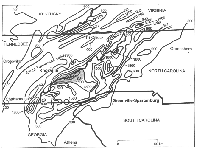
Figure 1. Smoothed elevation map of the southern Appalachian region with the stations considered for the study (contours in m MSL, shaded area denotes Smoky Mountains, foehn stations in boldface letters, boldface lines denote state lines). Sites not shown in this figure are the Atlanta observation site (ATL), which is located around 100 km (~60 mi) southwest of Athens, and the Atlanta sounding site (FFC), which is located around 120 km (~72 mi) southwest of Athens.
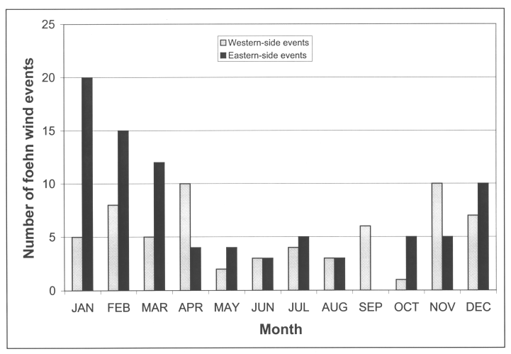
Figure 2. Monthly frequency of foehn wind events near the southern Appalachians.
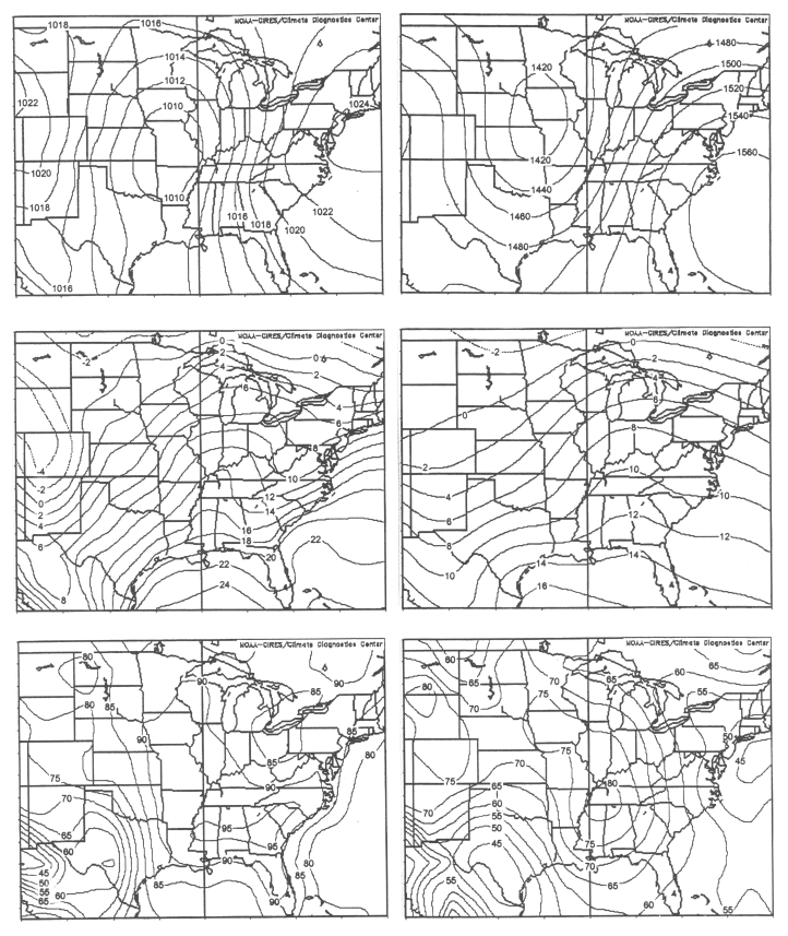
Figure 3. Composite maps of all western-side foehn wind events with (top left) surface isobars (hPa), (top right) 850-hPa isoheights (m), (center left) surface isotherms (0C), (center right) 850-hPa isotherms (0C), (bottom left) surface relative humidity (%), and (bottom right) 850-hPa relative humidity (%).
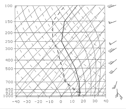
Figure 4. Composite of 1200 UTC soundings at Athens (AHN) and Atlanta (FFC) from all western-side foehn wind events.
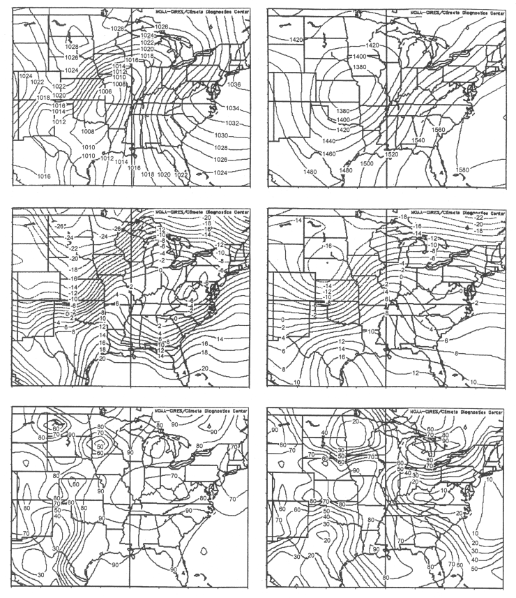
Figure 5. Same as in Fig. 3 but for the 26 January 1996 event at 1200 UTC.
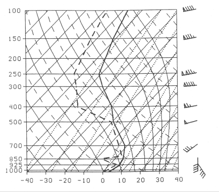
Figure 6. 1200 UTC FFC sounding for the 26 January 1996 event.
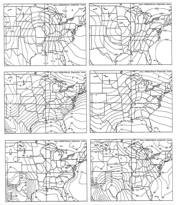
Figure 7. Same as in Fig. 3 but for western-side foehn wind events with dewpoint rises.
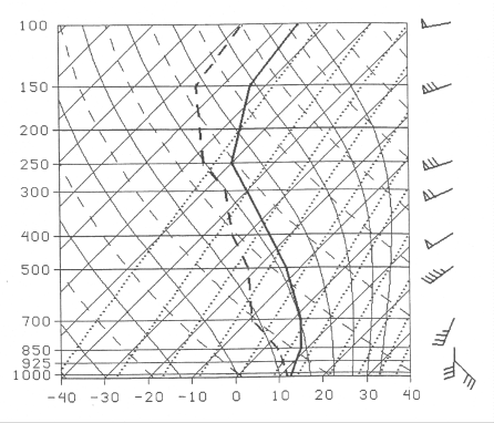
Figure 8. Same as in Fig. 4 but for western-side foehn wind events with dewpoint rises.
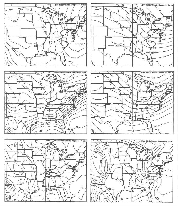
Figure 9. Same as in Fig. 3 but for all eastern-side foehn wind events.
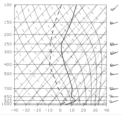
Figure 10. Composite of 1200 UTC soundings at Greensboro (GSO) from all eastern-side foehn wind events.
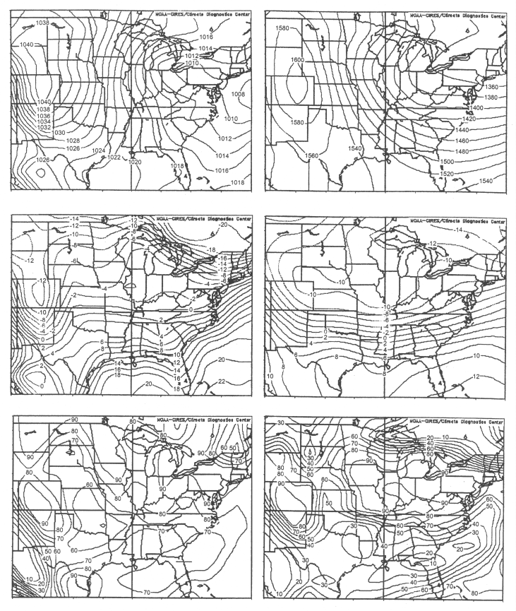
Figure 11. Same as in Fig. 3 but for the 4 February 2000 event at 1200 UTC.
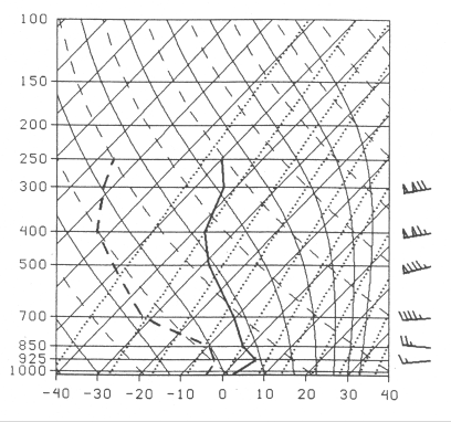
Figure 12. 1200 UTC GSO sounding for the 4 February 2000 event.
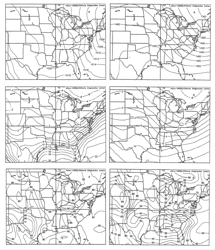
Figure 13. Same as in Fig. 3 but for eastern-side foehn wind events with dewpoint rises.
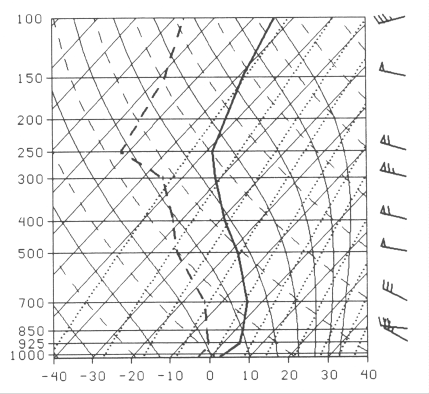
Figure 14. Same as in Fig. 10 but for eastern-side foehn wind events with dewpoint rises.


 Local Radar
 Huntsville Radar
 Regional Satellite
 Graphical Forecast
 Weather Map