82nd Anniversary - September 21, 1938
Home | History | Meteorology | Damage Photos | Video | News Clippings | References
Check out WFO Boston/Norton's 1938 Hurricane Page
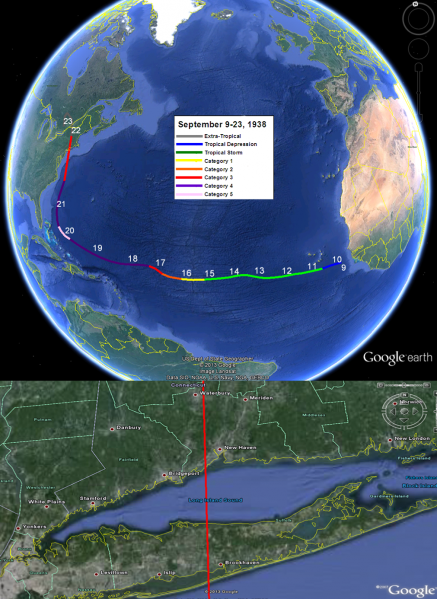
On September 21, 1938, one of the most destructive and powerful hurricanes in recorded history struck Long Island and Southern New England. The storm developed near the Cape Verde Islands on September 9, tracking across the Atlantic and up the Eastern Seaboard. The storm hit Long Island and Southern Connecticut on September 21, moving at a forward speed of 47 mph! Sustained hurricane force winds were felt across central and eastern Long Island and southeastern Connecticut. The hurricane produced a destructive storm surge flooding coastal communities as well as producing three to seven inches of rainfall.
This website provides historical information, meteorology, damage photos, video, and news clippings of this powerful hurricane. A focus will be on the locations within the National Weather Service New York, NY forecast area.
Click Panel for Larger Image
|
Track data courtesy of the National Hurricane Center: Hurricane Research Division: Re-analysis Project |
FACTS
-
Max Recorded Sustained Wind: 121 mph at Blue Hill Observatory, MA
-
Max Recorded Wind Gust: 186 mph at Blue Hill Observatory, MA
-
Highest Sustained Wind Measurement not Influenced by Terrain: 109 mph at Fishers Island, NY (Landsea et al 2013)
-
Lowest Observed Pressure: 27.94 in (946.2 mb) at Bellport, NY
-
Estimated Lowest Pressure: 27.79 in (941 mb) near Brentwood, NY as the wind and pressure centers were slightly displaced due to its fast speed and extra-tropical transition (Landsea et al. 2013, National Hurricane Center; Hurricane Research Division Re-Analysis Project)
-
Speed at landfall: 47 mph (Landsea et al. 2013, National Hurricane Center; Hurricane Research Division Re-Analysis Project)
-
Peak Storm Surge: 17 ft. above normal high tide (Rhode Island)
-
Peak Wave Height: 50 ft. at Gloucester, MA
-
Deaths: 700
-
Homeless: Approx. 63,000
-
Homes/Buildings Destroyed: Approx. 8,900
-
Trees Destroyed: Approx. 2 Billion
-
Boats Lost or Destroyed: Approx. 3,300
-
Cost: $620 million (1938 Dollars); Equivalent to approx. $41 billion using 2005 inflation, wealth, and population normalization then estimated to 2010 Dollars (Blake and Gibney 2011).
Information from Francis (1998) unless otherwise noted.
|
|
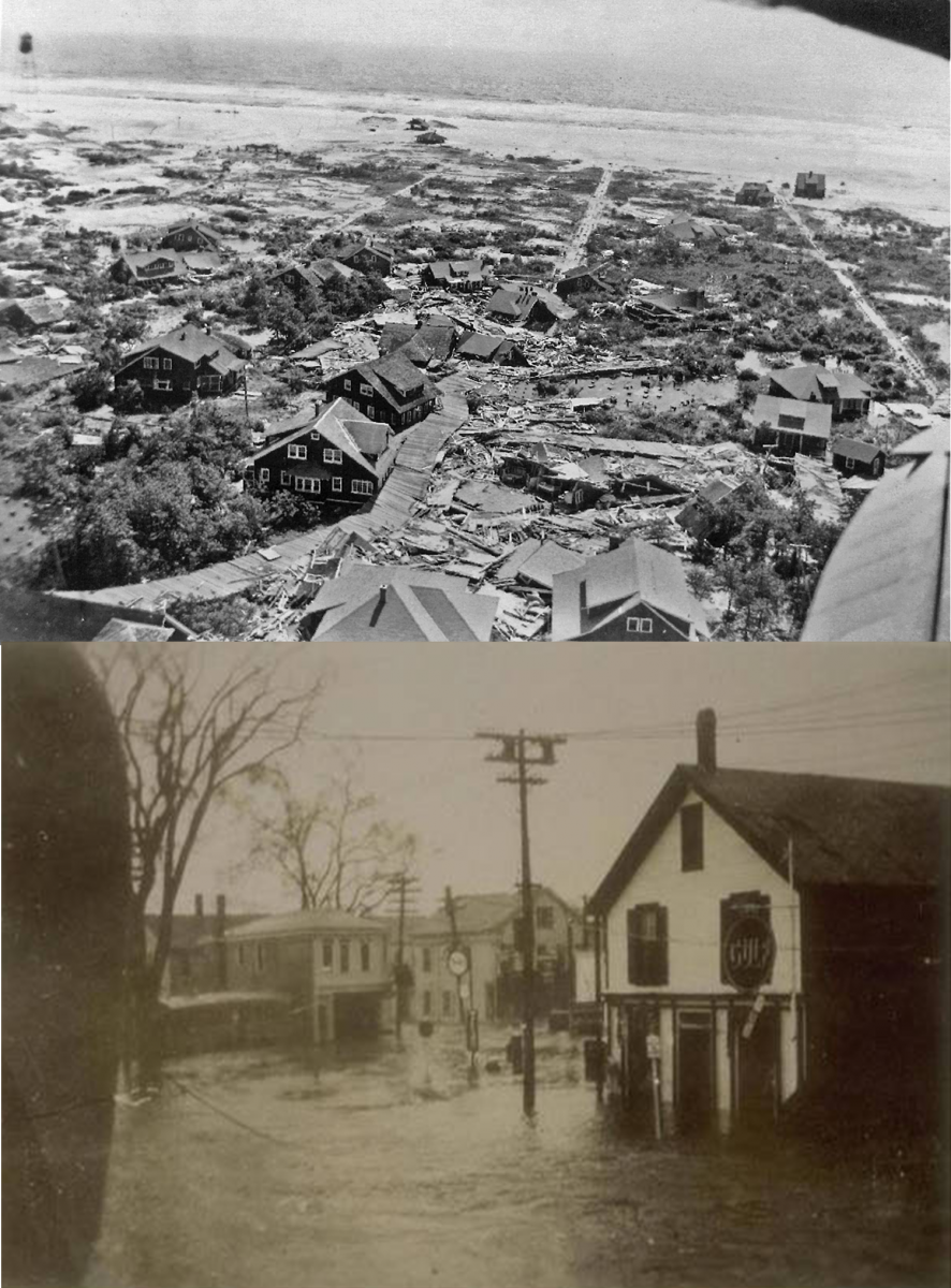
Damage to Saltaire, NY, top (Source: saltarian.com) and significant flooding to Mystic, CT, bottom (Source: MysticSeaport.org) |
Long Island Highlights
-
Landfall near Bellport, NY sometime between 2:10 and 2:40 pm EST as a Category 3 with an approx. pressure of 27.79 in (941 mb) and a 120 mph maximum sustained wind (Landsea et al. 2013).
-
Around 60 lives were lost and hundreds injured.
-
Thousands of homes and cottages destroyed or damaged. Many farms destroyed and their livestock killed.
-
6.2 million dollars (1938 Dollars) in damage in the Hamptons alone.
- A 16.75 ft. Mean Lower Low Water (MLLW) storm tide occurred at Willets Point which is a record height that still remains today (gauge later moved to Kings Point)
- An estimated storm tide of 15ft. across eastern Long Island. 8' MLLW was record at Port Jefferson.
- The storm surge in Western Long Island Sound was 5 1/2 hrs AFTER landfall.
-
20,000 miles of power and telephone lines downed (Mandia 2013).
-
Ten new inlets formed from the storm from Fire Island to East Hampton. The most notable was Shinnecock Inlet. A few others have since been filled by artificial means.
-
Montauk was an island temporarily.
-
LIRR tracks were washed out.
-
Fishing industry wiped out and half of the apple crop destroyed.
Southern Connecticut Highlights
-
Hurricane made second landfall around 4 pm somewhere between Bridgeport and New haven as a Category 3 with an approx. pressure of 27.94 (946 mb) and a 115 mph maximum sustained wind (Landsea et al. 2013).
-
Hundreds of lives were lost with many injured.
-
Extensive damage to homes, trees, and crops.
- The storm tide at New London was 10.58' MLLW which is a record tide that still remains today.
-
Stamford recorded a 14.1' MLLW storm tide and Bridgeport recorded a 12.8' MLLW storm tide.
-
Bridges, utilities, and railroads were wiped out.
-
Catastrophic damage to fishing fleets.
New York City Highlights
Storm tide of 8.21' was recorded at the battery.
-
Water rose 7' within 30 minutes in New York Harbor.
-
Central Park: 60 mph (30 ft.)
-
Daily News Bldg: 90 mph (500 ft.)
-
Empire State Bldg: est.120 mph (1250 ft.)
-
Battery: 70 mph with 80 mph gust (30 ft.)
|


 Coastal Flooding