
A slow moving front will bring rounds of strong to severe thunderstorms and heavy rainfall to the central Plains eastward to the east-central U.S.. The first widespread significant heat wave of summer for the Intermountain West and Plains is expected to develop today and expand through next week. Dangerous heat will continue to impact portions of the Southwest and Southeast. Read More >
Spokane, WA
Weather Forecast Office

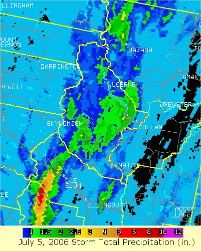
During the afternoon of July 5, 2006, an outbreak of severe thunderstorms along the east slopes of the Cascades resulted in significant flash flooding in and near Lake Chelan. The radar loop above depicts the track of several strong to severe thunderstorms between 400 pm PDT and approximately 630 pm PDT. Radar estimated between 2.5 and 3.0 inches of rain within about a 2 hour time span (see radar storm total precipitation image below). Runoff from the very heavy rain resulted in a significant rock/debris slide along Slide Ridge south of Lake Chelan. The slide damaged portions of South Lakeshore drive between Lake Chelan State Park and Twenty-five Mile Creek State Park.
Lakeshore Drive below Slide Ridge
Photos Courtesy of Patrick Lonergran


By Kerry Jones
US Dept of Commerce
National Oceanic and Atmospheric Administration
National Weather Service
Spokane, WA
2601 N Rambo Rd.
Spokane, WA 99224
509-244-0110
Comments? Questions? Please Contact Us.

